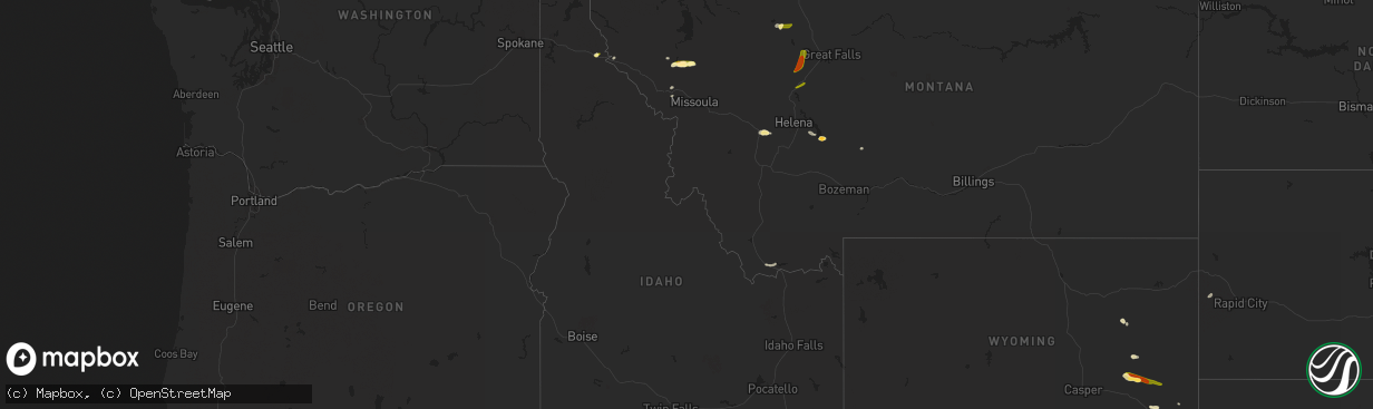
Hail Map in Idaho on August 25, 2022
The weather event in Idaho on August 25, 2022 includes Hail map. 4 states and 28 cities were impacted and suffered possible damage. The total estimated number of properties impacted is 678.
Want more than just the map?
Turn this storm into a full workflow.
- Owner + property data so you know who to knock
- OnDemand branded weather history reports to win the "did we even have hail?" argument
- RoofTrace estimate so reps stop guessing numbers at the door
Bought this map? Upgrade within 7 days and we'll credit the $230. (10-15 min setup call)
Hail
678
Estimated number of impacted properties by a 1.00" hail or larger0
Estimated number of impacted properties by a 1.75" hail or larger0
Estimated number of impacted properties by a 2.50" hail or largerStorm reports in Idaho
Idaho
| Date | Description |
|---|---|
| 08/25/20223:32 PM CDT | Hail covered interstate 90 east of wallace during the storm. Time estimated from radar. |
| 08/25/20223:30 PM CDT | A local report indicates 1.00 inch wind near WALLACE |
| 08/25/20223:04 PM CDT | Downed tree and wires near big creek road. Time estimated from radar. |
| 08/24/202211:47 PM CDT | At 447 PM MDT, a severe thunderstorm was located near Monida, or 30 miles northwest of Idmon, moving east at 15 mph. HAZARD...Half dollar size hail. SOURCE...Radar indicated. IMPACT...Damage to vehicles is expected. Locations impacted include... Monida and Snowline. |
All States Impacted by Hail Map on August 25, 2022
Cities Impacted by Hail Map on August 25, 2022
- Townsend, MT
- Alberton, MT
- Silverton, ID
- Wallace, ID
- Douglas, WY
- Lead, SD
- Saint Regis, MT
- Deer Lodge, MT
- Glendo, WY
- Lima, MT
- Gillette, WY
- Saint Ignatius, MT
- Dixon, MT
- Charlo, MT
- Winston, MT
- Huson, MT
- White Sulphur Springs, MT
- Plains, MT
- Choteau, MT
- Lusk, WY
- Garrison, MT
- Avon, MT
- Sun River, MT
- Fort Shaw, MT
- Cascade, MT
- Wolf Creek, MT
- Lost Springs, WY
- Shawnee, WY


