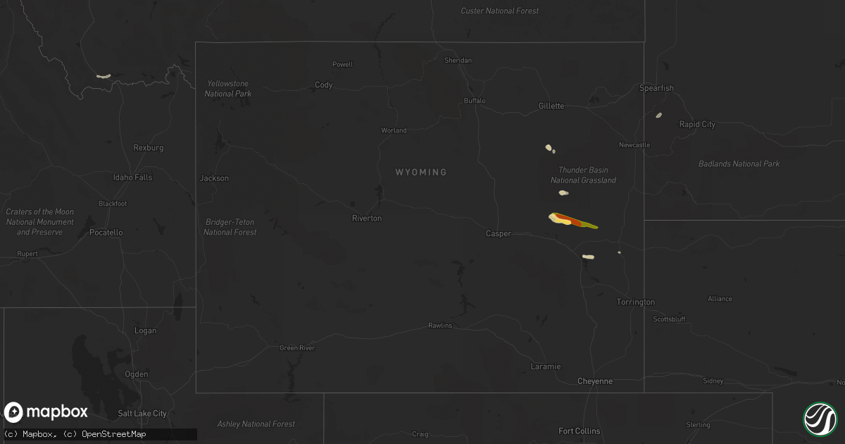
Hail Map in Wyoming on August 25, 2022
Get this storm
August 25 map
$229
one time, instant access
Download today. No call, no setup
Keep the $229
Bought the map and want the full workflow? Apply the entire $229 to a subscription within 7 days. None of it is wasted.
Every map, not just this one
This buys you this map. Subscription and you get every map we run, in the markets you choose from a few cities to whole states to nationwide. Plus real-time alerts the moment a storm fires.
Contact data
Name, contact info, occupancy, even credit band for addresses in the footprint. You go from where it hit to who to call.
Become the source they trust
Unlimited branding weather history reports on demand. You already have the documented answer ready for the property owner, and you are the one who showed up with it.
Property data and RoofTrace estimates
Pull up any address you have got, its value and the exact code rules for that jurisdiction, straight from One Click Code. Then RoofTrace estimates the squares, pitch, and roof value, priced the way you price.
Storm reports in Wyoming
Wyoming
| Date | Description |
|---|---|
| 08/25/20226:50 PM CDT | Social media post shows video of ping pong to golf ball size hail with accumulation along state highway 39. Traffic was at a stand still. |
| 08/25/20222:09 AM CDT | At 708 PM MDT, a severe thunderstorm was located 11 miles southeast of Redbird, or 17 miles southwest of Edgemont, moving northeast at 35 mph. HAZARD...60 mph wind gusts and quarter size hail. SOURCE...Radar indicated. IMPACT...Hail damage to vehicles is expected. Expect wind damage to roofs, siding, and trees. Locations impacted include... Provo and Edgemont. |
| 08/25/20221:54 AM CDT | At 654 PM MDT, a severe thunderstorm was located near Manning Ranch, or 23 miles northwest of Lusk, moving east at 25 mph. HAZARD...Two inch hail. SOURCE...Radar indicated. IMPACT...People and animals outdoors will be injured. Expect damage to roofs, siding, windows, and vehicles. Locations impacted include... Manville, Manning Ranch and Lance Creek. |
| 08/25/20221:35 AM CDT | At 635 PM MDT, a severe thunderstorm was located 11 miles east of Wright, moving east at 15 mph. HAZARD...Ping pong ball size hail. SOURCE...Radar indicated. IMPACT...People and animals outdoors will be injured. Expect damage to roofs, siding, windows, and vehicles. This severe thunderstorm will remain over mainly rural areas of southeastern Campbell and southwestern Weston Counties, moving along Highway 450. |
| 08/25/20221:13 AM CDT | At 613 PM MDT, a severe thunderstorm was located near Manning Ranch, or 30 miles northeast of Douglas, moving east at 30 mph. HAZARD...Two inch hail. SOURCE...Radar indicated. IMPACT...People and animals outdoors will be injured. Expect damage to roofs, siding, windows, and vehicles. Locations impacted include... Manning Ranch and Lance Creek. |
| 08/25/20221:10 AM CDT | At 610 PM MDT, a severe thunderstorm was located near Rawhide Buttes, or 8 miles south of Lusk, moving east at 30 mph. HAZARD...Quarter size hail. SOURCE...Radar indicated. IMPACT...Damage to vehicles is expected. Locations impacted include... Lusk. |
| 08/25/202212:46 AM CDT | At 546 PM MDT, a severe thunderstorm was located 10 miles northeast of Two Moon Campground, or 21 miles southwest of Lusk, moving east at 30 mph. HAZARD...Ping pong ball size hail and 60 mph wind gusts. SOURCE...Radar indicated. IMPACT...People and animals outdoors will be injured. Expect hail damage to roofs, siding, windows, and vehicles. Expect wind damage to roofs, siding, and trees. This severe thunderstorm will remain over mainly rural areas of southwestern Niobrara, northwestern Goshen, northeastern Platte and southeastern Converse Counties. |
| 08/25/202212:39 AM CDT | At 539 PM MDT, a severe thunderstorm was located 8 miles north of Bill, or 32 miles southeast of Wright, moving east at 30 mph. HAZARD...Ping pong ball size hail and 60 mph wind gusts. SOURCE...Radar indicated. IMPACT...People and animals outdoors will be injured. Expect hail damage to roofs, siding, windows, and vehicles. Expect wind damage to roofs, siding, and trees. This severe thunderstorm will remain over mainly rural areas of west central Niobrara and northeastern Converse Counties. |
| 08/25/202212:31 AM CDT | At 531 PM MDT, a severe thunderstorm was located 5 miles north of Wright, moving east at 20 mph. HAZARD...Ping pong ball size hail and 60 mph wind gusts. SOURCE...Radar indicated. IMPACT...People and animals outdoors will be injured. Expect hail damage to roofs, siding, windows, and vehicles. Expect wind damage to roofs, siding, and trees. This severe thunderstorm will remain over mainly rural areas of southeastern Campbell County. |
| 08/25/202212:28 AM CDT | At 528 PM MDT, a severe thunderstorm was located 12 miles southwest of Bill, or 22 miles north of Douglas, moving east at 30 mph. HAZARD...Golf ball size hail and 60 mph wind gusts. SOURCE...Radar indicated. IMPACT...People and animals outdoors will be injured. Expect hail damage to roofs, siding, windows, and vehicles. Expect wind damage to roofs, siding, and trees. This severe thunderstorm will remain over mainly rural areas of east central Converse County. |
| 08/24/20227:35 PM CDT | Strong winds reported from the public... Which caused a camper to move. |
All States Impacted by Hail Map on August 25, 2022
Cities Impacted by Hail Map on August 25, 2022
- Townsend, MT
- Alberton, MT
- Silverton, ID
- Wallace, ID
- Douglas, WY
- Lead, SD
- Saint Regis, MT
- Deer Lodge, MT
- Glendo, WY
- Lima, MT
- Gillette, WY
- Saint Ignatius, MT
- Dixon, MT
- Charlo, MT
- Winston, MT
- Huson, MT
- White Sulphur Springs, MT
- Plains, MT
- Choteau, MT
- Lusk, WY
- Garrison, MT
- Avon, MT
- Sun River, MT
- Fort Shaw, MT
- Cascade, MT
- Wolf Creek, MT
- Lost Springs, WY
- Shawnee, WY


