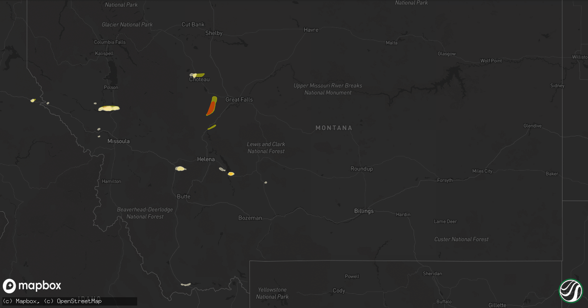
Hail Map in Montana on August 25, 2022
Get this storm
August 25 map
$229
one time, instant access
Download today. No call, no setup
Keep the $229
Bought the map and want the full workflow? Apply the entire $229 to a subscription within 7 days. None of it is wasted.
Every map, not just this one
This buys you this map. Subscription and you get every map we run, in the markets you choose from a few cities to whole states to nationwide. Plus real-time alerts the moment a storm fires.
Contact data
Name, contact info, occupancy, even credit band for addresses in the footprint. You go from where it hit to who to call.
Become the source they trust
Unlimited branding weather history reports on demand. You already have the documented answer ready for the property owner, and you are the one who showed up with it.
Property data and RoofTrace estimates
Pull up any address you have got, its value and the exact code rules for that jurisdiction, straight from One Click Code. Then RoofTrace estimates the squares, pitch, and roof value, priced the way you price.
Storm reports in Montana
Montana
| Date | Description |
|---|---|
| 08/25/20226:15 PM CDT | Public report via social media of quarter-sized hail. |
| 08/25/20226:07 PM CDT | Social media post from near townsend... Mt. |
| 08/25/20225:46 PM CDT | Ping pong size hail... Heavy rain and strong winds. |
| 08/25/20225:30 PM CDT | Public report through social media of ping pong sized hail quickly reducing to marble sized hail. |
| 08/25/20222:31 AM CDT | At 730 PM MDT, severe thunderstorms were located along a line extending from near Fort Shaw to near Sun River, moving north at 20 mph. HAZARD...Half dollar size hail. SOURCE...Radar indicated. IMPACT...Damage to vehicles is expected. Locations impacted include... Fort Shaw, Fort Shaw and Sun River. |
| 08/25/20222:22 AM CDT | At 721 PM MDT, a severe thunderstorm was located 10 miles south of Fairfield, or 22 miles northwest of Cascade. Movement is east at 10 mph. HAZARD...Half dollar size hail. SOURCE...Radar indicated. IMPACT...Damage to vehicles is expected. This severe thunderstorm will remain over mainly rural areas of central Lewis and Clark, southeastern Teton and northwestern Cascade Counties. |
| 08/25/20221:37 AM CDT | At 636 PM MDT, a severe thunderstorm was located 11 miles west of Cascade, moving northeast at 25 mph. HAZARD...Ping pong ball size hail. SOURCE...Radar indicated. IMPACT...People and animals outdoors will be injured. Expect damage to roofs, siding, windows, and vehicles. Locations impacted include... Simms. |
| 08/25/20221:24 AM CDT | At 622 PM MDT, a severe thunderstorm was located near Choteau, moving east at 15 mph. HAZARD...Two inch hail and 70 mph wind gusts. SOURCE...Radar indicated. IMPACT...People and animals outdoors will be injured. Expect hail damage to roofs, siding, windows, and vehicles. Expect considerable tree damage. Wind damage is also likely to mobile homes, roofs, and outbuildings. Locations impacted include... Choteau, Dutton, Power, Collins and Farmington. |
| 08/25/202212:51 AM CDT | At 551 PM MDT, a severe thunderstorm was located 24 miles southeast of White Sulphur Springs, moving east at 10 mph. HAZARD...Quarter size hail. SOURCE...Radar indicated. IMPACT...Damage to vehicles is expected. This severe thunderstorm will remain over mainly rural areas of southeastern Meagher County. |
| 08/25/202212:37 AM CDT | At 537 PM MDT, a severe thunderstorm was located 8 miles northwest of Choteau, moving east at 20 mph. HAZARD...60 mph wind gusts and quarter size hail. SOURCE...Radar indicated. IMPACT...Hail damage to vehicles is expected. Expect wind damage to roofs, siding, and trees. Locations impacted include... Choteau and Farmington. |
| 08/25/202212:06 AM CDT | At 506 PM MDT, a severe thunderstorm was located near Townsend, moving southeast at 20 mph. HAZARD...Half dollar size hail. SOURCE...Radar indicated. IMPACT...Damage to vehicles is expected. Locations impacted include... Townsend. |
| 08/24/202211:39 PM CDT | At 439 PM MDT, a severe thunderstorm was located 11 miles northwest of Wisdom, or 37 miles southwest of Anaconda, moving northeast at 15 mph. HAZARD...Quarter size hail. SOURCE...Radar indicated. IMPACT...Damage to vehicles is expected. This severe thunderstorm will remain over mainly rural areas of northwestern Beaverhead County. |
| 08/24/202211:35 PM CDT | At 435 PM MDT, a severe thunderstorm was located near Old Agency, or 23 miles south of Polson, moving east at 15 mph. HAZARD...60 mph wind gusts and half dollar size hail. SOURCE...Radar indicated. IMPACT...Hail damage to vehicles is expected. Expect wind damage to roofs, siding, and trees. Locations impacted include... Ravalli, St. Ignatius, Old Agency, Dixon, Allentown, Moiese, Kicking Horse, Charlo and Fort Connah. |
| 08/24/20229:52 PM CDT | At 252 PM MDT, a severe thunderstorm was located near Alberton, or 20 miles northwest of Missoula, moving east at 10 mph. HAZARD...60 mph wind gusts and quarter size hail and very heavy rain. SOURCE...Radar indicated. IMPACT...Hail damage to vehicles is expected. Expect wind damage to roofs, siding, and trees. Locations impacted include... Frenchtown, Huson and Ninemile. |
| 08/24/20228:29 PM CDT | At 129 PM PDT, a severe thunderstorm was located over Wallace, moving east at 15 mph. HAZARD...Quarter size hail. SOURCE...Radar indicated. IMPACT...Damage to vehicles is expected. Locations impacted include... Wallace and Mullan. This includes Interstate 90 in Idaho between mile markers 61 and 73. |
| 08/24/20227:16 PM CDT | Large amounts of hail up to 1 inch in diameter on highway 220 4 miles outside of choteau. |
All States Impacted by Hail Map on August 25, 2022
Cities Impacted by Hail Map on August 25, 2022
- Townsend, MT
- Alberton, MT
- Silverton, ID
- Wallace, ID
- Douglas, WY
- Lead, SD
- Saint Regis, MT
- Deer Lodge, MT
- Glendo, WY
- Lima, MT
- Gillette, WY
- Saint Ignatius, MT
- Dixon, MT
- Charlo, MT
- Winston, MT
- Huson, MT
- White Sulphur Springs, MT
- Plains, MT
- Choteau, MT
- Lusk, WY
- Garrison, MT
- Avon, MT
- Sun River, MT
- Fort Shaw, MT
- Cascade, MT
- Wolf Creek, MT
- Lost Springs, WY
- Shawnee, WY


