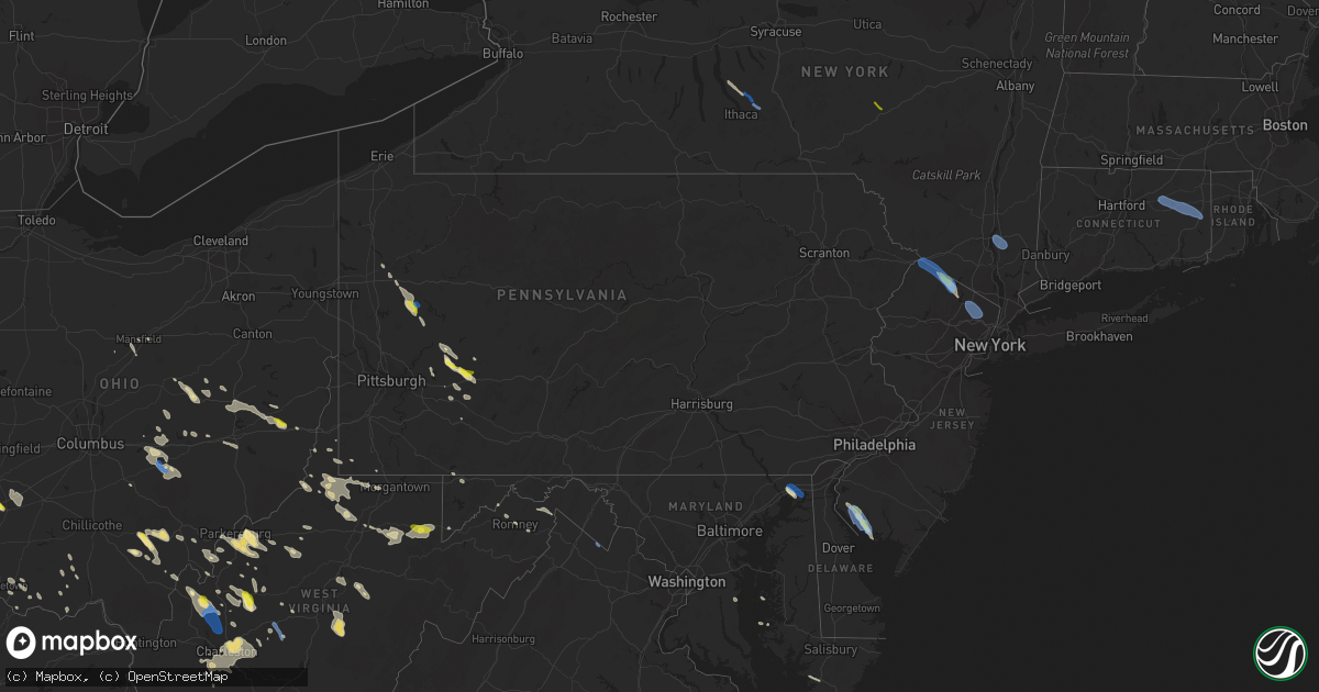
Hail Map in Pennsylvania on August 25, 2020
Get this storm
August 25 map
$229
one time, instant access
Download today. No call, no setup
Keep the $229
Bought the map and want the full workflow? Apply the entire $229 to a subscription within 7 days. None of it is wasted.
Every map, not just this one
This buys you this map. Subscription and you get every map we run, in the markets you choose from a few cities to whole states to nationwide. Plus real-time alerts the moment a storm fires.
Contact data
Name, contact info, occupancy, even credit band for addresses in the footprint. You go from where it hit to who to call.
Become the source they trust
Unlimited branding weather history reports on demand. You already have the documented answer ready for the property owner, and you are the one who showed up with it.
Property data and RoofTrace estimates
Pull up any address you have got, its value and the exact code rules for that jurisdiction, straight from One Click Code. Then RoofTrace estimates the squares, pitch, and roof value, priced the way you price.
Storm reports in Pennsylvania
Pennsylvania
| Date | Description |
|---|---|
| 08/25/20204:08 PM CDT | Tree down on 200 block of porter ave in rostraver township |
| 08/25/20203:29 PM CDT | Several trees reported down in mount pleasant township |
| 08/25/20203:15 PM CDT | Trees and power lines down in cook township off linn run rd. |
| 08/25/20203:07 PM CDT | Tree down on 4400 block milligan cove rd. |
| 08/25/20203:00 PM CDT | Tree down at allegheny rd and geller rd. |
| 08/25/20202:45 PM CDT | Tree down across roadway. |
| 08/25/20202:38 PM CDT | Tree reported down near intersection of wilpen rd and ramsey rd |
| 08/25/20202:35 PM CDT | Tree down blocking both lanes of roadway. |
| 08/25/20202:35 PM CDT | Tree on wires near intersection of view ave and forest lane. |
| 08/25/20202:30 PM CDT | Wires down. |
| 08/25/20202:30 PM CDT | Tree down on wires. |
| 08/25/20202:18 PM CDT | Several trees and power lines reported down in and around hopewell township |
| 08/25/20202:16 PM CDT | Trees down on power lines in derry township by route 981 and shortcut rd |
| 08/25/20202:15 PM CDT | Multiple trees down in fairfield township |
| 08/25/20202:05 PM CDT | Power line down on the 800 block of pittsburgh st |
| 08/25/20202:05 PM CDT | Tree down on 200 block of garrigan hill rd |
| 08/25/20202:03 PM CDT | Tree reported down off deep hollow rd |
| 08/25/20201:52 PM CDT | Estimated near 10 trees down at residence with additional trees down in the neighborhood. Metal also ripped off shed roofing. |
| 08/25/20201:47 PM CDT | A local report indicates 1.25 inch wind near ISELIN |
| 08/25/20201:47 PM CDT | Several snapped trees and damage to a barn along route 217 between blairsville and aultman. Time estimated based on radar. |
| 08/25/20201:01 PM CDT | Trees and power lines reported down in worthington pa |
| 08/25/202012:55 PM CDT | Large trees down and split in half... And laying on power lines in cowansville pa |
| 08/25/202012:50 PM CDT | Armstrong 911 reports trees down all across northern armstrong county. |
| 08/25/202012:47 PM CDT | A local report indicates 1.00 inch wind near CHICORA |
| 08/25/202012:40 PM CDT | Trees and wires down; power out near fairview area. |
| 08/25/202012:33 PM CDT | Trees and wires down in washington township |
| 08/25/20208:15 AM CDT | Trees down at 125 ashbaugh rd. |
| 08/25/20207:40 AM CDT | Multiple trees down at maggie rd and keysertown rd. |
| 08/25/20207:40 AM CDT | Power lines reported down. |
| 08/25/20207:29 AM CDT | At 1228 PM EDT, severe thunderstorms were located along a line extending from 6 miles west of Tionesta to 6 miles southeast of Greenville, moving southeast at 45 mph. HAZARD...Wind gusts to 60 mph and quarter-size hail. SOURCE...Radar. IMPACT...Minor hail damage to vehicles is possible. Expect wind damage to trees and power lines, resulting in some power outages. Locations impacted include... Oil City... Grove City... Franklin... Knox... Sugarcreek... Mercer... Hasson Heights... Stoneboro... Seneca... Harrisville... Polk... Sandy Lake...This includes the following highways... Interstate 79 in Pennsylvania between mile markers 113 and 132. Interstate 80 in Pennsylvania between mile markers 14 and 49. |
| 08/25/20207:25 AM CDT | Tree reported down along route 119 near country farms garden center. |
| 08/25/20207:17 AM CDT | Trees down at 125 ashbaugh rd. |
| 08/25/20206:58 AM CDT | At 1158 AM EDT, severe thunderstorms were located along a line extending from near Titusville to near Kinsman, moving southeast at 50 mph. HAZARD...Wind gusts to 60 mph and quarter-size hail. SOURCE...Radar. IMPACT...Minor hail damage to vehicles is possible. Expect wind damage to trees and power lines, resulting in some power outages. Locations impacted include... Hermitage... Oil City... Franklin... Greenville... Sugarcreek... Mercer... Hasson Heights... Stoneboro... Seneca... Polk... Sandy Lake... Clark...This includes the following highways... Interstate 79 in Pennsylvania between mile markers 120 and 138. Interstate 80 in Pennsylvania between mile markers 6 and 8. |
| 08/25/20206:55 AM CDT | At 1154 AM EDT, a severe thunderstorm was located over Meadville, moving east at 30 mph. HAZARD...60 mph wind gusts and quarter size hail. SOURCE...Radar indicated. IMPACT...Minor damage to vehicles is possible. Expect damage to trees and power lines. Locations impacted include... Meadville, Adamsville, Atlantic, Pymatuning Central, Cochranton, Conneaut Lake, Conneaut Lakeshore, Geneva and Hartstown. |
| 08/25/20204:05 AM CDT | At 905 AM EDT, a severe thunderstorm was located near South Connellsville, or near Connellsville, moving southeast at 30 mph. HAZARD...Wind gusts to 60 mph and quarter-size hail. SOURCE...Radar. IMPACT...Minor hail damage to vehicles is possible. Expect wind damage to trees and power lines, resulting in some power outages. Locations impacted include... Connellsville... South Connellsville... Seven Springs... Dunbar... Ohiopyle... Mill Run... Indian Head... Normalville... |
| 08/25/20203:23 AM CDT | At 822 AM EDT, severe thunderstorms were located along a line extending from near Southmont to 8 miles south of Lawson Heights, moving southeast at 30 mph. HAZARD...60 mph wind gusts and quarter size hail. SOURCE...Radar indicated. IMPACT...Hail damage to vehicles is expected. Expect wind damage to trees, roofs, and siding. Locations impacted include... Somerset, Windber, Meyersdale, Berlin, Friedens, Boswell, Davidsville, Central City, Jerome, Acosta, New Centerville, Ogletown, Tire Hill, Rockwood, Jennerstown, Hooversville, Garrett, Indian Lake, Stoystown and Shanksville.This includes The Pennsylvania Turnpike from mile markers 100 to 129. |
| 08/25/20203:18 AM CDT | At 818 AM EDT, a severe thunderstorm was located near Ligonier, or 7 miles southeast of Latrobe, moving south at 30 mph. HAZARD...Wind gusts to 60 mph and quarter-size hail. SOURCE...Radar. IMPACT...Minor hail damage to vehicles is possible. Expect wind damage to trees and power lines, resulting in some power outages. Locations impacted include... Latrobe... McChesneytown-Loyalhanna... Derry... Lawson Heights... Ligonier... Seven Springs... Calumet-Norvelt... Youngstown... Laurel Mountain... Donegal... Champion... Indian Head...This includes Pennsylvania Turnpike between mile markers 81 and 99. |
| 08/25/20202:55 AM CDT | At 754 AM EDT, a severe thunderstorm was located over Delmont, or 8 miles northeast of Jeannette, moving southeast at 25 mph. HAZARD...Wind gusts to 60 mph and quarter-size hail. SOURCE...Radar. IMPACT...Minor hail damage to vehicles is possible. Expect wind damage to trees and power lines, resulting in some power outages. Locations impacted include... Monroeville... Greensburg... Jeannette... Latrobe... Vandergrift... Homer City... Apollo... Murrysville... New Kensington... Lower Burrell... Irwin... McChesneytown-Loyalhanna...This includes the following highways... Interstate 70 in Pennsylvania between mile markers 55 and 57. Pennsylvania Turnpike between mile markers 59 and 81. |
| 08/25/20201:41 AM CDT | At 641 AM EDT, a severe thunderstorm was located near Sarver, or 8 miles south of Butler, moving east at 25 mph. HAZARD...Wind gusts to 60 mph and quarter-size hail. SOURCE...Radar. IMPACT...Minor hail damage to vehicles is possible. Expect wind damage to trees and power lines, resulting in some power outages. Locations impacted include... Vandergrift... Lower Burrell... Harrison Township... Tarentum... Natrona Heights... Brackenridge... Leechburg... Sarver... Freeport... Saxonburg... West Leechburg... Curtisville... |
| 08/25/202012:57 AM CDT | At 557 PM EDT, a severe thunderstorm was located over Reeders, or near Mount Pocono, moving southeast at 35 mph. HAZARD...60 mph wind gusts. SOURCE...Radar indicated. IMPACT...Damage to roofs, siding, trees, and power lines is possible. Locations impacted include... Mount Pocono, East Stroudsburg, Hackettstown, Washington, Blairstown, Bangor, Pen Argyl, Wind Gap, Belvidere, Harmony, Oxford, Hope, East Bangor, Brass Castle, Stormville, Brodheadsville, Delaware Water Gap, Tannersville, Sun Valley and Great Meadows-Vienna.This includes the following highways... Interstate 80 in Pennsylvania between mile markers 296 and 314. Interstate 80 in New Jersey between mile markers 0 and 22. Interstate 380 in Pennsylvania between mile markers 0 and 1. |
| 08/25/202012:05 AM CDT | At 505 PM EDT, a severe thunderstorm was located near Connellsville, moving southeast at 25 mph. HAZARD...Wind gusts to 60 mph. SOURCE...Radar. IMPACT...Expect damage to trees and power lines, resulting in some power outages. Locations impacted include... Connellsville... South Connellsville... Seven Springs... Champion... Mill Run... Indian Head... Normalville... |
| 08/25/202012:01 AM CDT | At 500 PM EDT, a severe thunderstorm was located over Gastonville, moving southeast at 25 mph. HAZARD...Wind gusts to 60 mph. SOURCE...Radar. IMPACT...Expect damage to trees and power lines, resulting in some power outages. Locations impacted include... Bethel Park... Gastonville... South Park Township... Jefferson Hills... Monessen... California... Donora... Monongahela... Charleroi... West Newton... Bentleyville... Perryopolis...This includes Interstate 70 in Pennsylvania between mile markers 30and 50. |
| 08/24/202011:52 PM CDT | At 451 PM EDT, a severe thunderstorm was located over High Point, or near Port Jervis, moving southeast at 40 mph. HAZARD...60 mph wind gusts and penny size hail. SOURCE...Radar indicated. IMPACT...Expect damage to trees and power lines. This severe thunderstorm will be near... Unionville around 500 PM EDT. Warwick around 515 PM EDT. West Milford and Greenwood Lake around 520 PM EDT. Ringwood and Sloatsburg around 530 PM EDT. |
| 08/24/202011:13 PM CDT | At 413 PM EDT, a severe thunderstorm was located near Ligonier, or 11 miles southeast of Latrobe, moving southeast at 25 mph. HAZARD...Wind gusts to 60 mph. SOURCE...Radar. IMPACT...Expect damage to trees and power lines, resulting in some power outages. Locations impacted include... Ligonier... Laurel Mountain... Laurel Mountain State Park... This includes Pennsylvania Turnpike between mile markers 92 and 99. |
| 08/24/202010:15 PM CDT | At 314 PM EDT, severe thunderstorms were located along a line extending from near Belsano to near New Kensington, moving southeast at 50 mph. HAZARD...Wind gusts to 60 mph and quarter-size hail. SOURCE...Radar. IMPACT...Minor hail damage to vehicles is possible. Expect wind damage to trees and power lines, resulting in some power outages. Locations impacted include... Greensburg... Jeannette... Latrobe... Homer City... Murrysville... McChesneytown-Loyalhanna... Blairsville... Youngwood... Derry... Delmont... Lawson Heights... New Stanton...This includes Pennsylvania Turnpike between mile markers 77 and 99. |
| 08/24/202010:00 PM CDT | At 259 PM EDT, a severe thunderstorm was located near Black Lick, moving southeast at 40 mph. HAZARD...60 mph wind gusts and quarter size hail. SOURCE...Radar indicated. IMPACT...Hail damage to vehicles is expected. Expect wind damage to trees, roofs, and siding. Locations impacted include... Johnstown, Westmont, Windber, Belmont, Portage, Geistown, Southmont, Friedens, Vinco, Boswell, Dale, East Conemaugh, Salix-Beauty Line Park, Davidsville, Central City, Beaverdale-Lloydell, Paint, Jerome, South Fork and Scalp Level.This includes The Pennsylvania Turnpike from mile markers 126 to 129. |
| 08/24/20209:34 PM CDT | At 233 PM EDT, severe thunderstorms were located along a line extending from near Northern Cambria to near Trafford, moving south at 40 mph. HAZARD...Wind gusts to 60 mph and quarter-size hail. SOURCE...Radar. IMPACT...Minor hail damage to vehicles is possible. Expect wind damage to trees and power lines, resulting in some power outages. Locations impacted include... Monroeville... Greensburg... Indiana... Jeannette... Latrobe... Homer City... Plum... Murrysville... Irwin... McChesneytown-Loyalhanna... Blairsville... Manor...This includes Pennsylvania Turnpike between mile markers 57 and 72,and near mile marker 96. |
| 08/24/20209:09 PM CDT | At 209 PM EDT, severe thunderstorms were located along a line extending from 8 miles north of Indiana to Mars, moving southeast at 40 mph. HAZARD...Wind gusts to 60 mph and quarter-size hail. SOURCE...Radar. IMPACT...Minor hail damage to vehicles is possible. Expect wind damage to trees and power lines, resulting in some power outages. Locations impacted include... Penn Hills... Indiana... Vandergrift... Kittanning... Apollo... Shaler Township... Plum... Murrysville... Hampton Township... New Kensington... Lower Burrell... Harrison Township...This includes Pennsylvania Turnpike between mile markers 40 and 52. |
| 08/24/20209:07 PM CDT | At 207 PM EDT, a severe thunderstorm was located near Slippery Rock, or 9 miles southeast of Grove City, moving southeast at 45 mph. HAZARD...Wind gusts to 60 mph and quarter-size hail. SOURCE...Radar. IMPACT...Minor hail damage to vehicles is possible. Expect wind damage to trees and power lines, resulting in some power outages. Locations impacted include... Grove City... Shanor-Northvue... Slippery Rock... Prospect... Chicora... East Brady... Harrisville... Parker... Plain Grove Township... Emlenton... Bruin... Clintonville...This includes the following highways... Interstate 79 in Pennsylvania between mile markers 103 and 106, and between mile markers 118 and 124. Interstate 80 in Pennsylvania between mile markers 20 and 45. |
| 08/24/20208:36 PM CDT | At 136 PM EDT, severe thunderstorms were located along a line extending from near Meridian to near Kittanning, moving south at 50 mph. HAZARD...Wind gusts to 60 mph and quarter-size hail. SOURCE...Radar. IMPACT...Minor hail damage to vehicles is possible. Expect wind damage to trees and power lines, resulting in some power outages. Locations impacted include... Butler... Kittanning... Rimersburg... Homeacre-Lyndora... Shanor-Northvue... Meridian... Ford City... Meadowood... Oak Hills... Sarver... Freeport... Mars... |
| 08/24/20208:12 PM CDT | At 112 PM EDT, severe thunderstorms were located along a line extending from near Rimersburg to 6 miles west of Slippery Rock, moving southeast at 35 mph. HAZARD...Wind gusts to 60 mph and quarter-size hail. SOURCE...Radar. IMPACT...Minor hail damage to vehicles is possible. Expect wind damage to trees and power lines, resulting in some power outages. Locations impacted include... Grove City... Knox... Shanor-Northvue... Slippery Rock... Chicora... Seneca... Harrisville... Parker... Plain Grove Township... Sligo... Emlenton... Bruin...This includes the following highways... Interstate 79 in Pennsylvania between mile markers 105 and 106, and between mile markers 111 and 122. Interstate 80 in Pennsylvania between mile markers 18 and 57. |
All States Impacted by Hail Map on August 25, 2020
Cities Impacted by Hail Map on August 25, 2020
- Dexter, ME
- Saint Clairsville, OH
- Middletown, OH
- Mass City, MI
- Fresno, OH
- Coshocton, OH
- Ford City, PA
- Bradley, ME
- Newark, OH
- Heath, OH
- Blairsville, PA
- Apollo, PA
- Procious, WV
- Clendenin, WV
- West Union, OH
- Winchester, OH
- Newport, NJ
- Bloomery, WV
- Paw Paw, WV
- Slanesville, WV
- Ripley, OH
- Mesick, MI
- Keyser, WV
- Pelkie, MI
- Onekama, MI
- Bear Lake, MI
- Tracys Landing, MD
- Wautoma, WI
- Neshkoro, WI
- Redgranite, WI
- Berlin, WI
- Markesan, WI
- Brandon, WI
- Princeton, WI
- Green Lake, WI
- Ripon, WI
- Elkview, WV
- Charleston, WV
- Accident, MD
- Parkersburg, WV
- Davisville, WV
- Walker, WV
- Waverly, WV
- Gandeeville, WV
- Spencer, WV
- Athens, OH
- Albany, OH
- New Marshfield, OH
- Hope, ME
- Thomaston, ME
- Metamora, IN
- Connersville, IN
- Laurel, IN
- Brookville, IN
- Portland, OH
- Racine, OH
- South Charleston, WV
- Old Town, ME
- Bangor, ME
- Orono, ME
- Elizabeth, WV
- Mineral Wells, WV
- Waynesburg, PA
- Mount Morris, PA
- Honor, MI
- Beulah, MI
- Frankfort, MI
- Benzonia, MI
- Wellston, OH
- Webster Springs, WV
- Westover, MD
- Princess Anne, MD
- Hamden, OH
- McArthur, OH
- Ellsworth, ME
- Orland, ME
- Clarksburg, PA
- Avonmore, PA
- Saltsburg, PA
- Randolph, WI
- Fall River, WI
- Hart, MI
- Hesperia, MI
- Walkerville, MI
- Harrisville, WV
- Berea, WV
- Josephine, PA
- Black Lick, PA
- Wilmington, OH
- Wilkesville, OH
- Waupun, WI
- Fairwater, WI
- Pine River, WI
- Mount Desert, ME
- Bar Harbor, ME
- Highland Lakes, NJ
- Glenwood, NJ
- Vernon, NJ
- Hewitt, NJ
- West Milford, NJ
- Greenwich, NJ
- Bridgeton, NJ
- Cedarville, NJ
- Newaygo, MI
- Shelocta, PA
- Spring Church, PA
- Nisula, MI
- Ontonagon, MI
- Belmont, OH
- Flushing, OH
- Bethesda, OH
- Piedmont, OH
- Freeport, OH
- Millersburg, OH
- Gowen, MI
- Cedar Springs, MI
- Greenville, MI
- Hawley, MN
- Leon, WV
- Sand Lake, MI
- Wisconsin Dells, WI
- Oxford, WI
- Sardinia, OH
- Russellville, OH
- Georgetown, OH
- Rio, WI
- Portage, WI
- Cambria, WI
- Pardeeville, WI
- Montello, WI
- Ludington, MI
- Pentwater, MI
- Blount, WV
- Hernshaw, WV
- Alum Creek, WV
- Ridgeview, WV
- Tad, WV
- Nellis, WV
- Tornado, WV
- Sod, WV
- Belle, WV
- Ashford, WV
- Cambridge, MD
- Belleville, WV
- Lumberport, WV
- New Freeport, PA
- Holbrook, PA
- Kaleva, MI
- Manistee, MI
- Arcadia, MI
- Cincinnati, OH
- Hebron, KY
- Washington, WV
- Petroleum, WV
- Duck, WV
- Frametown, WV
- Somerset, OH
- New Lexington, OH
- Rivesville, WV
- Maidsville, WV
- Morgantown, WV
- Guysville, OH
- Lake George, MN
- Park Rapids, MN
- Clarksville, OH
- Grand Marsh, WI
- West Union, WV
- Littleton, WV
- Warsaw, OH
- Chicora, PA
- Petrolia, PA
- Karns City, PA
- Colfax, ND
- Walcott, ND
- Champion, MI
- Otway, OH
- Lucasville, OH
- Aberdeen, OH
- Lyndon Station, WI
- Eddington, ME
- New Martinsville, WV
- Enon, OH
- Medway, OH
- Yellow Springs, OH
- Fairborn, OH
- Port Deposit, MD
- Charlestown, MD
- North East, MD
- Saint Michaels, MD
- Bozman, MD
- Wittman, MD
- Parsons, WV
- Aurora, WV
- Rowlesburg, WV
- Terra Alta, WV
- Stoneboro, PA
- Jackson Center, PA
- Le Roy, WV
- Reedy, WV
- Palestine, WV
- Wahpeton, ND
- Garnett, SC
- Moatsville, WV
- Philippi, WV
- Grafton, WV
- Thornton, WV
- Milford, ME
- Jamestown, OH
- Port William, OH
- Sabina, OH
- Bancroft, WI
- Dalton, WI
- Endeavor, WI
- Genoa, NY
- Groton, NY
- Locke, NY
- Lansing, NY
- King Ferry, NY
- Ripley, WV
- Mauston, WI
- Copemish, MI
- Thompsonville, MI
- Export, PA
- Oregonia, OH
- Fremont, MI
- Deeth, NV
- Rogerson, ID
- Jackpot, NV
- Peebles, OH
- Piketon, OH
- Wisconsin Rapids, WI
- Mansfield, OH
- Rockland, ME
- Owls Head, ME
- Brownsville, IN
- Liberty, IN
- Frazeysburg, OH
- Blanchester, OH
- Fayetteville, OH
- White Pine, MI
- New Alexandria, PA
- North Haven, ME
- West Chester, OH
- Hamilton, OH
- French Creek, WV
- Michigamme, MI
- Erbacon, WV
- Cowen, WV
- Diana, WV
- Paris, MI
- Rodney, MI
- Big Rapids, MI
- Plainfield, WI
- Ligonier, PA
- Bolivar, PA
- Proctor, WV
- Clarksburg, WV
- Mannington, WV
- Smithfield, WV
- Folsom, WV
- Wallace, WV
- Shinnston, WV
- Peytona, WV
- Sussex, NJ
- Ringwood, NJ
- Bloomingdale, NJ
- Wanaque, NJ
- Lanse, MI
- Mount Orab, OH
- Creston, WV
- Hilliards, PA
- Harrisville, PA
- West Sunbury, PA
- Parker, PA
- Boyers, PA
- Cairo, WV
- Ravenswood, WV
- Long Bottom, OH
- New Lisbon, WI
- Lebanon, OH
- Mason, OH
- Lafayette, IN
- Zanesville, OH
- Lidgerwood, ND
- Wyndmere, ND
- Bridgeport, WV
- Flemington, WV
- Orr, MN
- Burton, WV
- Fairview, WV
- Hundred, WV
- Metz, WV
- Cameron, WV
- Wana, WV
- Pine Grove, WV
- Jacksonburg, WV
- Zaleski, OH
- Vinton, OH
- Langsville, OH
- Thornville, OH
- Glenford, OH
- New Carlisle, OH
- Pennsboro, WV
- Rockport, WV
- Moundsville, WV
- Callaway, MN
- Kenduskeag, ME
- Hudson, ME
- Chase, MI
- Reed City, MI
- Walton, WV
- Gay, WV
- Huger, SC
- Fox Lake, WI
- Rarden, OH
- Boyce, VA
- Homer City, PA
- Mount Perry, OH
- Wind Ridge, PA
- Aleppo, PA
- Romney, WV
- Tippecanoe, OH
- Pickett, WI
- Laporte, MN
- Galion, OH
- East Brady, PA
- Worthington, PA
- New Florence, PA
- Hibbing, MN
- Rushville, IN
- Newcomerstown, OH
- Stone Creek, OH
- Reedsville, OH
- Clarks Hill, IN
- Surry, ME
- Oakland, MD
- Rock Cave, WV
- Crawford, WV
- Tallmansville, WV
- Port Washington, OH
- Kimbolton, OH
- Auburn, WV
- Perryville, MD
- Morrow, OH
- Brinkhaven, OH
- Augusta, WV
- Stout, OH
- Bucksport, ME
- Foster, WV
- Burlington, WV
- Senecaville, OH
- Byesville, OH
- New Concord, OH
- Cambridge, OH
- Julian, WV
- Given, WV
- Kenna, WV
- Point Pleasant, WV
- Buffalo, WV
- Southside, WV
- Liberty, WV
- Letart, WV
- Bellville, OH
- Orma, WV
- Lancaster, OH
- Pineland, SC
- Mecosta, MI
- Kindred, ND
- Port Edwards, WI
- Clay, WV
- Bomont, WV
- Brooksville, KY
- Lake Park, MN
- Briggsville, WI
- Friesland, WI
- Middleburg, VA
- Dallas, WV
- Crooksville, OH
- Junction City, OH
- Hebron, OH
- Rushville, OH
- Fortescue, NJ
- Salem, NJ
- Camden, OH
- Newfoundland, NJ
- Latrobe, PA
- Stahlstown, PA
- Addison, PA
- Reader, WV
- Smithville, WV
- Pullman, WV
- Hankinson, ND
- Derry, PA
- Grove City, PA
- Lincolnville, ME
- Monroe, OH
- Nashport, OH
- Warren, ME
- Hannibal, OH
- Sardis, OH
- Paden City, WV
- Clarington, OH
- Gardiner, ME
- Rockport, ME
- Walkersville, WV
- Exeter, RI
- Bidwell, OH
- Norwich, OH
- Indiana, PA
- Cheshire, OH
- Blissfield, OH
- Killbuck, OH
- Berryville, VA
- Summit Point, WV
- Elkton, MD
- Rising Sun, MD
- Springfield, OH
- Warwick, NY
- Shiloh, NJ
- Freeville, NY
- Dryden, NY
- Wappingers Falls, NY
- Putnam Valley, NY
- Fishkill, NY
- Beacon, NY
- Cold Spring, NY
- Hopewell Junction, NY
- Laurens, NY
- Otego, NY
- Oneonta, NY
- West Oneonta, NY
- Coral, PA
- Evans, WV
- Tunnelton, WV
- Coventry, CT
- North Windham, CT
- Hampton, CT
- Moosup, CT
- Chaplin, CT
- Brooklyn, CT
- Mansfield Center, CT
- Storrs Mansfield, CT
- Windham, CT
- Plainfield, CT
- Canterbury, CT
- Waldwick, NJ
- Oakland, NJ
- Haledon, NJ
- Midland Park, NJ
- Ho Ho Kus, NJ
- Glen Rock, NJ
- Paterson, NJ
- Allendale, NJ
- Wyckoff, NJ
- Ridgewood, NJ
- Fair Lawn, NJ
- Franklin Lakes, NJ
- Hawthorne, NJ
- Mahwah, NJ
- Saddle Brook, NJ
- Wayne, NJ
- Paramus, NJ
- Elmwood Park, NJ
- Port Jervis, NY
- Pine Island, NY
- Unionville, NY
- Westtown, NY
- Montague, NJ
- Matamoras, PA
- Baraga, MI
- Poland, ME
- Mechanic Falls, ME
- Clinton, ME
- Newton, WV
- Wallback, WV
- Maysel, WV
- Red House, WV
- Poca, WV


