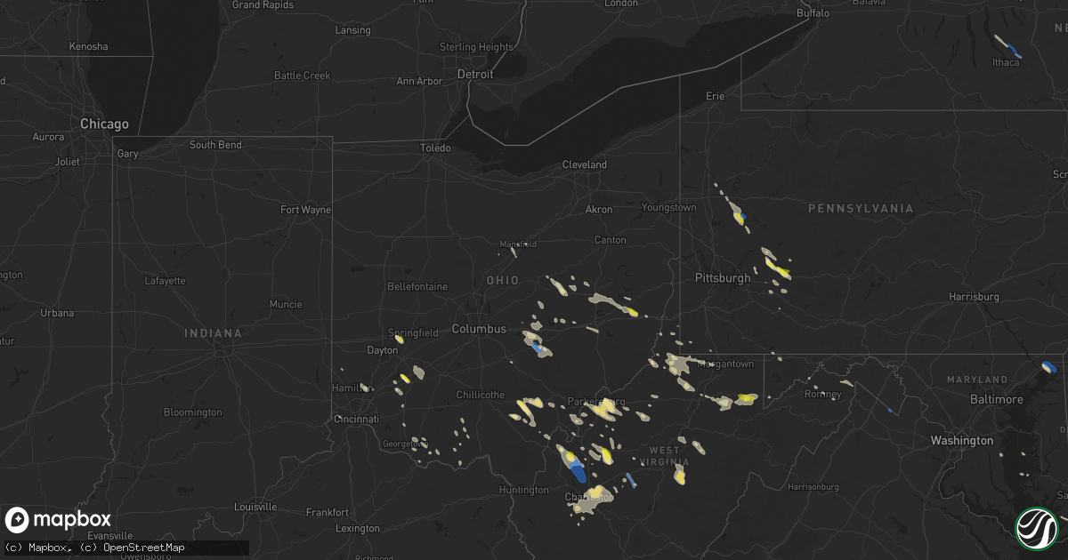
Hail Map in Ohio on August 25, 2020
Get this storm
August 25 map
$229
one time, instant access
Download today. No call, no setup
Keep the $229
Bought the map and want the full workflow? Apply the entire $229 to a subscription within 7 days. None of it is wasted.
Every map, not just this one
This buys you this map. Subscription and you get every map we run, in the markets you choose from a few cities to whole states to nationwide. Plus real-time alerts the moment a storm fires.
Contact data
Name, contact info, occupancy, even credit band for addresses in the footprint. You go from where it hit to who to call.
Become the source they trust
Unlimited branding weather history reports on demand. You already have the documented answer ready for the property owner, and you are the one who showed up with it.
Property data and RoofTrace estimates
Pull up any address you have got, its value and the exact code rules for that jurisdiction, straight from One Click Code. Then RoofTrace estimates the squares, pitch, and roof value, priced the way you price.
Storm reports in Ohio
Ohio
| Date | Description |
|---|---|
| 08/25/20205:07 PM CDT | Numerous trees downed. |
| 08/25/20204:35 PM CDT | Spotter relayed report from a judge of several trees down. Time and location vectored from spotter information and radar. |
| 08/25/20204:35 PM CDT | Multiple trees and power poles down including on addison pike... Poplar ridge rd... Little kyger rd and rousch hollow. Hwy department reports damage so bad that it may |
| 08/25/20204:30 PM CDT | Trees down in vinton and bidwell communities. Report courtesy of wchs. |
| 08/25/20204:24 PM CDT | One 20 inch diameter tree snapped. Another 8 inch diameter tree limb downed. Time estimated from radar. |
| 08/25/20204:15 PM CDT | Multiple trees down. |
| 08/25/20204:07 PM CDT | Trees down. |
| 08/25/20204:07 PM CDT | A couple trees and several large limbs downed. |
| 08/25/20203:50 PM CDT | Measured on home weather station. |
| 08/25/20203:45 PM CDT | Numerous trees down around town. |
| 08/25/20203:41 PM CDT | Several trees down... Some blocking roads. Time estiamted from call center time and radar. |
| 08/25/20203:37 PM CDT | Several trees down in far southwest portion of athens township... Some blocking roads. Time esitmated from caller information and radar. |
| 08/25/20203:34 PM CDT | Two trees... Several large limbs blown down. Time estimated from radar data. |
| 08/25/20203:30 PM CDT | Numerous trees down. |
| 08/25/20203:30 PM CDT | Multiple large trees downed with several uprooted onto houses. |
| 08/25/20203:28 PM CDT | Three trees and many branches down. Time estimated from radar data. |
| 08/25/20203:06 PM CDT | Several large branches down... Blocking road. Time estimated from radar. |
| 08/25/20203:02 PM CDT | Three mature trees downed near county line and hempstead road. |
| 08/25/20203:02 PM CDT | Tree down on car. Time estimated from radar data. |
| 08/25/20203:02 PM CDT | Tree down in road. Time estimated from radar data. |
| 08/25/20203:02 PM CDT | Multiple reports of trees down across county. Most reports were from the logan area. |
| 08/25/20203:01 PM CDT | Large limb blown down. Time estimated from radar data. |
| 08/25/20203:00 PM CDT | Tree down on house and lines. Time estimated from radar data. |
| 08/25/20203:00 PM CDT | A local report indicates 1.25 inch wind near 5 NW WILMINGTON |
| 08/25/20202:52 PM CDT | One 10-12 inch tree limb downed. Time estimated from radar. |
| 08/25/20202:45 PM CDT | Numerous trees down in the town of somerset. |
| 08/25/20202:30 PM CDT | Muskingum ema reports damage across much of the county including trees and powerlines down around intersection of norfield rd and state route 93. |
| 08/25/20202:17 PM CDT | Semi trailer blown over on us-22 near reed road. Time estimated from radar. |
| 08/25/20202:17 PM CDT | Pole down at ohio 72 and black road. Time estimated from radar data. |
| 08/25/20202:07 PM CDT | Several trees down in and around warsaw village with power lines also down from trees laying on them. |
| 08/25/20201:53 PM CDT | Roof blown off barn on zimmerman road. Time estimated from radar data. |
| 08/25/20201:50 PM CDT | A local report indicates 1.00 inch wind near 1 S FLUSHING |
| 08/25/20201:28 PM CDT | Trees and power lines down in west lafeytte |
| 08/25/202012:55 PM CDT | A local report indicates 1.00 inch wind near ENON |
| 08/25/20207:42 AM CDT | At 1242 PM EDT, a severe thunderstorm was located over Mansfield, moving southeast at 15 mph. HAZARD...60 mph wind gusts and quarter size hail. SOURCE...Radar indicated. IMPACT...Minor damage to vehicles is possible. Expect damage to trees and power lines. Locations impacted include... Mansfield, Ontario, Loudonville, Hayesville, Perrysville, Lucas, Mifflin and Mohicanville. |
| 08/25/20201:19 AM CDT | At 619 PM EDT, a severe thunderstorm was located near Delhi Hills, moving south at 25 mph. HAZARD...60 mph wind gusts. SOURCE...Radar indicated. IMPACT...Expect damage to trees and power lines. Locations impacted include... Florence, Independence, Erlanger, Elsmere, Villa Hills, Walton, Oakbrook, Burlington, Union, Richwood, Bank Lick, Ricedale, Hueys Corners, Constance, Hebron, Beaverlick, Piner, Cvg Airport, Verona and Francisville.This includes the following Interstates... I-71 in Kentucky between mile markers 71 and 77. I-75 in Kentucky between mile markers 169 and 184. |
| 08/25/202012:24 AM CDT | At 524 PM EDT, a severe thunderstorm was located over Ravenswood, or 8 miles south of Forked Run State Park, moving southeast at 40 mph. HAZARD...60 mph wind gusts. SOURCE...Radar indicated. IMPACT...Expect damage to roofs, siding, and trees. Locations impacted include... Ripley, Spencer, Elizabeth, Grantsville, Ravenswood, Sandyville, Arnoldsburg, Reedy, Statts Mills, Cherry, Mount Zion, Kentuck, Left Hand, Lucille, Big Springs, Brohard, Annamoriah, Fairplain, Peewee and Harmony.This includes the following highways... Interstate 79 between mile markers 29 and 30. Interstate 77 in West Virginia between mile markers 125 and 157. |
| 08/24/202011:34 PM CDT | At 434 PM EDT, a severe thunderstorm was located near Pickerington, moving southeast at 35 mph. HAZARD...60 mph wind gusts and quarter size hail. SOURCE...Radar indicated. IMPACT...Minor hail damage to vehicles is possible. Expect wind damage to trees and power lines. Locations impacted include... Lancaster, Reynoldsburg, Pickerington, Pataskala, Canal Winchester, Baltimore, Bremen, Millersport, Pleasantville, Hide-A-Way Hills, Etna, Thurston, Kirkersville, Carroll, Sugar Grove, Rushville, West Rushville, Fairfield County Airport, Hideaway Hills and State Route 158 at State Route 204.This includes I-70 in Ohio between mile markers 112 and 122. |
| 08/24/202011:27 PM CDT | At 427 PM EDT, a severe thunderstorm was located near Nelsonville, moving southeast at 25 mph. HAZARD...60 mph wind gusts and penny size hail. SOURCE...Radar indicated. IMPACT...Expect damage to roofs, siding, and trees. Locations impacted include... Athens, Nelsonville, Chauncey, Buchtel, Amesville, Stroud Run State Park and The Plains. |
| 08/24/202011:26 PM CDT | At 425 PM EDT, a severe thunderstorm was located near Morrow, moving southeast at 35 mph. HAZARD...60 mph wind gusts and quarter size hail. SOURCE...Radar indicated. IMPACT...Minor hail damage to vehicles is possible. Expect wind damage to trees and power lines. Locations impacted include... Hillsboro, Blanchester, Lynchburg, Russell, New Market, Clarksville, Martinsville, Midland, Fort Ancient, Danville in Highland County, Middleboro, Westboro, Cuba, State Route 350 at US Route 22 and Cowan Lake State Park.This includes I-71 in Ohio between mile markers 35 and 40. |
| 08/24/202011:23 PM CDT | At 423 PM EDT, a severe thunderstorm was located near Camden, moving southeast at 20 mph. HAZARD...60 mph wind gusts and quarter size hail. SOURCE...Radar indicated. IMPACT...Minor hail damage to vehicles is possible. Expect wind damage to trees and power lines. Locations impacted include... Middletown, Mason, Monroe, Trenton, South Middletown, Seven Mile, Williamsdale, Olde West Chester, Four Bridges, Wetherington, Darrtown, New Miami, Somerville, West Elkton, Jacksonburg, Hughes, Maud, Collinsville, Maustown and Pisgah.This includes I-75 in Ohio between mile markers 21 and 28. |
| 08/24/202010:57 PM CDT | At 356 PM EDT, a severe thunderstorm was located 8 miles south of New Concord, or 13 miles east of Zanesville, moving southeast at 30 mph. HAZARD...Wind gusts to 60 mph. SOURCE...Radar. IMPACT...Expect damage to trees and power lines, resulting in some power outages. Locations impacted include... Zanesville... Caldwell... New Concord... Byesville... South Zanesville... Dudley... Philo... Pleasant Grove... Senecaville... Pleasant City... Cumberland... Summerfield...This includes the following highways... Interstate 70 in Ohio between mile markers 159 and 174. Interstate 77 in Ohio between mile markers 18 and 41. |
| 08/24/202010:55 PM CDT | At 355 PM EDT, a severe thunderstorm was located over Perry State Forest, moving southeast at 20 mph. HAZARD...60 mph wind gusts and penny size hail. SOURCE...Radar indicated. IMPACT...Expect damage to roofs, siding, and trees. Locations impacted include... New Lexington, Glouster, McConnelsville, Shawnee, Chesterhill, Perry State Forest, Crooksville, Junction City, Malta, Corning, Stockport, Jacksonville, Trimble, Bristol, Hemlock, Rendville, Burr Oak State Park, Hackney and Eagleport. |
| 08/24/202010:49 PM CDT | At 349 PM EDT, a severe thunderstorm was located near Hide-A-Way Hills, moving southeast at 25 mph. HAZARD...60 mph wind gusts and quarter size hail. SOURCE...Radar indicated. IMPACT...Minor hail damage to vehicles is possible. Expect wind damage to trees and power lines. Locations impacted include... Logan, Nelsonville, Hide-A-Way Hills, Starr, Murray City, Sugar Grove, Enterprise, Union Furnace, Rockbridge, Haydenville, Lake Logan State Park and Carbon Hill. |
| 08/24/202010:47 PM CDT | At 347 PM EDT, a severe thunderstorm was located 7 miles northwest of Wilmington, moving southeast at 25 mph. HAZARD...60 mph wind gusts and quarter size hail. SOURCE...Radar indicated. IMPACT...Minor hail damage to vehicles is possible. Expect wind damage to trees and power lines. Locations impacted include... Wilmington, New Vienna, Martinsville, New Antioch, Morrisville, Ogden, Oakland, Kingman, Burtonville and Interstate 71 at US Route 68.This includes I-71 in Ohio between mile markers 44 and 50. |
| 08/24/202010:39 PM CDT | At 338 PM EDT, a severe thunderstorm was located near Powhatan Point, or near Moundsville, moving southeast at 25 mph. HAZARD...Wind gusts to 60 mph and quarter-size hail. SOURCE...Radar. IMPACT...Minor hail damage to vehicles is possible. Expect wind damage to trees and power lines, resulting in some power outages. Locations impacted include... Wheeling... Moundsville... Martins Ferry... New Martinsville... St. Clairsville... Bellaire... Waynesburg... Bethlehem... Woodsfield... Mannington... Triadelphia... Shadyside...This includes the following highways... Interstate 70 in Ohio between mile markers 217 and 225. Interstate 70 in West Virginia between mile markers 0 and 10. Interstate 79 in Pennsylvania between mile markers 3 and 18. |
| 08/24/202010:26 PM CDT | At 325 PM EDT, a severe thunderstorm was located near Coshocton, moving southeast at 25 mph. HAZARD...Wind gusts to 60 mph and quarter-size hail. SOURCE...Radar. IMPACT...Minor hail damage to vehicles is possible. Expect wind damage to trees and power lines, resulting in some power outages. Locations impacted include... Coshocton... Cambridge... Freeport... Newcomerstown... Byesville... West Lafayette... Dresden... Antrim... Warsaw... Senecaville... Conesville... Holloway...This includes the following highways... Interstate 70 in Ohio between mile markers 174 and 196. Interstate 77 in Ohio between mile markers 41 and 68. |
| 08/24/202010:14 PM CDT | At 314 PM EDT, a severe thunderstorm was located near Somerset, moving southeast at 30 mph. HAZARD...60 mph wind gusts and penny size hail. SOURCE...Radar indicated. IMPACT...Expect damage to roofs, siding, and trees. Locations impacted include... New Lexington, Glouster, McConnelsville, Somerset, Shawnee, Perry State Forest, Crooksville, Junction City, Malta, Corning, Glenford, Hemlock, Rendville and Eagleport. |
| 08/24/202010:11 PM CDT | At 311 PM EDT, a severe thunderstorm was located near Frazeysburg, or 8 miles north of Zanesville, moving southeast at 30 mph. HAZARD...Wind gusts to 60 mph and quarter-size hail. SOURCE...Radar. IMPACT...Minor hail damage to vehicles is possible. Expect wind damage to trees and power lines, resulting in some power outages. Locations impacted include... Zanesville... Cambridge... New Concord... Byesville... South Zanesville... North Zanesville... Dresden... Frazeysburg... Philo... Pleasant Grove... Senecaville... Pleasant City...This includes the following highways... Interstate 70 in Ohio near mile marker 143, and between mile markers 145 and 184. Interstate 77 in Ohio between mile markers 32 and 47. |
| 08/24/202010:07 PM CDT | At 306 PM EDT, a severe thunderstorm was located near St. Clairsville, moving east at 25 mph. HAZARD...Wind gusts to 60 mph and quarter-size hail. SOURCE...Radar. IMPACT...Minor hail damage to vehicles is possible. Expect wind damage to trees and power lines, resulting in some power outages. Locations impacted include... Wheeling... Moundsville... Martins Ferry... St. Clairsville... Bellaire... Barnesville... Warwood... Bethlehem... West Liberty... Triadelphia... Clearview... Valley Grove...This includes the following highways... Interstate 70 in Ohio between mile markers 191 and 225. Interstate 70 in West Virginia between mile markers 0 and 14. Interstate 70 in Pennsylvania between mile markers 0 and 9. Interstate 79 in Pennsylvania between mile markers 28 and 29. |
| 08/24/20209:47 PM CDT | At 246 PM EDT, a severe thunderstorm was located 8 miles south of Killbuck, or 11 miles northwest of Coshocton, moving southeast at 25 mph. HAZARD...Wind gusts to 60 mph and quarter-size hail. SOURCE...Radar. IMPACT...Minor hail damage to vehicles is possible. Expect wind damage to trees and power lines, resulting in some power outages. Locations impacted include... Coshocton... West Lafayette... Warsaw... Conesville... Nellie... Chili... Walhonding... Layland... Bakersville... Blissfield... New Guilford... |
| 08/24/20209:23 PM CDT | At 222 PM EDT, a severe thunderstorm was located near Freeport, moving southeast at 25 mph. HAZARD...Wind gusts to 60 mph. SOURCE...Radar. IMPACT...Expect damage to trees and power lines, resulting in some power outages. Locations impacted include... Cambridge... St. Clairsville... Barnesville... Cadiz... Freeport... Bethesda... Antrim... Flushing... Adena... Dillonvale... Quaker City... Mount Pleasant...This includes the following highways... Interstate 70 in Ohio between mile markers 184 and 216. Interstate 77 in Ohio between mile markers 47 and 52. |
| 08/24/20208:57 PM CDT | At 157 PM EDT, a severe thunderstorm was located near Farmerstown, or 11 miles southwest of Dover, moving southeast at 25 mph. HAZARD...Wind gusts to 60 mph. SOURCE...Radar. IMPACT...Expect damage to trees and power lines, resulting in some power outages. Locations impacted include... New Philadelphia... Coshocton... Uhrichsville... Freeport... Newcomerstown... Dennison... West Lafayette... Sugarcreek... Gnadenhutten... Tuscarawas... Baltic... Midvale...This includes Interstate 77 in Ohio between mile markers 52 and 79. |
| 08/24/20208:53 PM CDT | At 153 PM EDT, a severe thunderstorm was located over Killbuck, or 7 miles southwest of Millersburg, moving southeast at 25 mph. HAZARD...Wind gusts to 60 mph. SOURCE...Radar. IMPACT...Expect damage to trees and power lines, resulting in some power outages. Locations impacted include... Coshocton... West Lafayette... Warsaw... Chili... Layland... Bakersville... Blissfield... This includes Interstate 77 in Ohio near mile marker 68. |
| 08/24/20208:45 PM CDT | At 144 PM EDT, a severe thunderstorm was located over Enon, moving southeast at 20 mph. HAZARD...60 mph wind gusts. SOURCE...Radar indicated. IMPACT...Expect damage to trees and power lines. Locations impacted include... Fairborn, Yellow Springs, Cedarville, Enon, Wilberforce, Donnelsville, Clifton, Green Meadows, Springfield Municipal Airport, Hustead, Holiday Valley, John Bryan State Park, Snyderville, Selma, Crystal Lakes, Pitchin, Gladstone, Medway and Park Layne.This includes I-70 in Ohio between mile markers 43 and 52. |
| 08/24/20208:43 PM CDT | At 143 PM EDT, a severe thunderstorm was located near Uhrichsville, moving southeast at 25 mph. HAZARD...Wind gusts to 60 mph. SOURCE...Radar. IMPACT...Expect damage to trees and power lines, resulting in some power outages. Locations impacted include... Uhrichsville... Cadiz... Freeport... Dennison... Gnadenhutten... Antrim... Tuscarawas... Port Washington... Stone Creek... Gilmore... Tippecanoe... Piedmont...This includes Interstate 77 in Ohio between mile markers 70 and 78. |
All States Impacted by Hail Map on August 25, 2020
Cities Impacted by Hail Map on August 25, 2020
- Dexter, ME
- Saint Clairsville, OH
- Middletown, OH
- Mass City, MI
- Fresno, OH
- Coshocton, OH
- Ford City, PA
- Bradley, ME
- Newark, OH
- Heath, OH
- Blairsville, PA
- Apollo, PA
- Procious, WV
- Clendenin, WV
- West Union, OH
- Winchester, OH
- Newport, NJ
- Bloomery, WV
- Paw Paw, WV
- Slanesville, WV
- Ripley, OH
- Mesick, MI
- Keyser, WV
- Pelkie, MI
- Onekama, MI
- Bear Lake, MI
- Tracys Landing, MD
- Wautoma, WI
- Neshkoro, WI
- Redgranite, WI
- Berlin, WI
- Markesan, WI
- Brandon, WI
- Princeton, WI
- Green Lake, WI
- Ripon, WI
- Elkview, WV
- Charleston, WV
- Accident, MD
- Parkersburg, WV
- Davisville, WV
- Walker, WV
- Waverly, WV
- Gandeeville, WV
- Spencer, WV
- Athens, OH
- Albany, OH
- New Marshfield, OH
- Hope, ME
- Thomaston, ME
- Metamora, IN
- Connersville, IN
- Laurel, IN
- Brookville, IN
- Portland, OH
- Racine, OH
- South Charleston, WV
- Old Town, ME
- Bangor, ME
- Orono, ME
- Elizabeth, WV
- Mineral Wells, WV
- Waynesburg, PA
- Mount Morris, PA
- Honor, MI
- Beulah, MI
- Frankfort, MI
- Benzonia, MI
- Wellston, OH
- Webster Springs, WV
- Westover, MD
- Princess Anne, MD
- Hamden, OH
- McArthur, OH
- Ellsworth, ME
- Orland, ME
- Clarksburg, PA
- Avonmore, PA
- Saltsburg, PA
- Randolph, WI
- Fall River, WI
- Hart, MI
- Hesperia, MI
- Walkerville, MI
- Harrisville, WV
- Berea, WV
- Josephine, PA
- Black Lick, PA
- Wilmington, OH
- Wilkesville, OH
- Waupun, WI
- Fairwater, WI
- Pine River, WI
- Mount Desert, ME
- Bar Harbor, ME
- Highland Lakes, NJ
- Glenwood, NJ
- Vernon, NJ
- Hewitt, NJ
- West Milford, NJ
- Greenwich, NJ
- Bridgeton, NJ
- Cedarville, NJ
- Newaygo, MI
- Shelocta, PA
- Spring Church, PA
- Nisula, MI
- Ontonagon, MI
- Belmont, OH
- Flushing, OH
- Bethesda, OH
- Piedmont, OH
- Freeport, OH
- Millersburg, OH
- Gowen, MI
- Cedar Springs, MI
- Greenville, MI
- Hawley, MN
- Leon, WV
- Sand Lake, MI
- Wisconsin Dells, WI
- Oxford, WI
- Sardinia, OH
- Russellville, OH
- Georgetown, OH
- Rio, WI
- Portage, WI
- Cambria, WI
- Pardeeville, WI
- Montello, WI
- Ludington, MI
- Pentwater, MI
- Blount, WV
- Hernshaw, WV
- Alum Creek, WV
- Ridgeview, WV
- Tad, WV
- Nellis, WV
- Tornado, WV
- Sod, WV
- Belle, WV
- Ashford, WV
- Cambridge, MD
- Belleville, WV
- Lumberport, WV
- New Freeport, PA
- Holbrook, PA
- Kaleva, MI
- Manistee, MI
- Arcadia, MI
- Cincinnati, OH
- Hebron, KY
- Washington, WV
- Petroleum, WV
- Duck, WV
- Frametown, WV
- Somerset, OH
- New Lexington, OH
- Rivesville, WV
- Maidsville, WV
- Morgantown, WV
- Guysville, OH
- Lake George, MN
- Park Rapids, MN
- Clarksville, OH
- Grand Marsh, WI
- West Union, WV
- Littleton, WV
- Warsaw, OH
- Chicora, PA
- Petrolia, PA
- Karns City, PA
- Colfax, ND
- Walcott, ND
- Champion, MI
- Otway, OH
- Lucasville, OH
- Aberdeen, OH
- Lyndon Station, WI
- Eddington, ME
- New Martinsville, WV
- Enon, OH
- Medway, OH
- Yellow Springs, OH
- Fairborn, OH
- Port Deposit, MD
- Charlestown, MD
- North East, MD
- Saint Michaels, MD
- Bozman, MD
- Wittman, MD
- Parsons, WV
- Aurora, WV
- Rowlesburg, WV
- Terra Alta, WV
- Stoneboro, PA
- Jackson Center, PA
- Le Roy, WV
- Reedy, WV
- Palestine, WV
- Wahpeton, ND
- Garnett, SC
- Moatsville, WV
- Philippi, WV
- Grafton, WV
- Thornton, WV
- Milford, ME
- Jamestown, OH
- Port William, OH
- Sabina, OH
- Bancroft, WI
- Dalton, WI
- Endeavor, WI
- Genoa, NY
- Groton, NY
- Locke, NY
- Lansing, NY
- King Ferry, NY
- Ripley, WV
- Mauston, WI
- Copemish, MI
- Thompsonville, MI
- Export, PA
- Oregonia, OH
- Fremont, MI
- Deeth, NV
- Rogerson, ID
- Jackpot, NV
- Peebles, OH
- Piketon, OH
- Wisconsin Rapids, WI
- Mansfield, OH
- Rockland, ME
- Owls Head, ME
- Brownsville, IN
- Liberty, IN
- Frazeysburg, OH
- Blanchester, OH
- Fayetteville, OH
- White Pine, MI
- New Alexandria, PA
- North Haven, ME
- West Chester, OH
- Hamilton, OH
- French Creek, WV
- Michigamme, MI
- Erbacon, WV
- Cowen, WV
- Diana, WV
- Paris, MI
- Rodney, MI
- Big Rapids, MI
- Plainfield, WI
- Ligonier, PA
- Bolivar, PA
- Proctor, WV
- Clarksburg, WV
- Mannington, WV
- Smithfield, WV
- Folsom, WV
- Wallace, WV
- Shinnston, WV
- Peytona, WV
- Sussex, NJ
- Ringwood, NJ
- Bloomingdale, NJ
- Wanaque, NJ
- Lanse, MI
- Mount Orab, OH
- Creston, WV
- Hilliards, PA
- Harrisville, PA
- West Sunbury, PA
- Parker, PA
- Boyers, PA
- Cairo, WV
- Ravenswood, WV
- Long Bottom, OH
- New Lisbon, WI
- Lebanon, OH
- Mason, OH
- Lafayette, IN
- Zanesville, OH
- Lidgerwood, ND
- Wyndmere, ND
- Bridgeport, WV
- Flemington, WV
- Orr, MN
- Burton, WV
- Fairview, WV
- Hundred, WV
- Metz, WV
- Cameron, WV
- Wana, WV
- Pine Grove, WV
- Jacksonburg, WV
- Zaleski, OH
- Vinton, OH
- Langsville, OH
- Thornville, OH
- Glenford, OH
- New Carlisle, OH
- Pennsboro, WV
- Rockport, WV
- Moundsville, WV
- Callaway, MN
- Kenduskeag, ME
- Hudson, ME
- Chase, MI
- Reed City, MI
- Walton, WV
- Gay, WV
- Huger, SC
- Fox Lake, WI
- Rarden, OH
- Boyce, VA
- Homer City, PA
- Mount Perry, OH
- Wind Ridge, PA
- Aleppo, PA
- Romney, WV
- Tippecanoe, OH
- Pickett, WI
- Laporte, MN
- Galion, OH
- East Brady, PA
- Worthington, PA
- New Florence, PA
- Hibbing, MN
- Rushville, IN
- Newcomerstown, OH
- Stone Creek, OH
- Reedsville, OH
- Clarks Hill, IN
- Surry, ME
- Oakland, MD
- Rock Cave, WV
- Crawford, WV
- Tallmansville, WV
- Port Washington, OH
- Kimbolton, OH
- Auburn, WV
- Perryville, MD
- Morrow, OH
- Brinkhaven, OH
- Augusta, WV
- Stout, OH
- Bucksport, ME
- Foster, WV
- Burlington, WV
- Senecaville, OH
- Byesville, OH
- New Concord, OH
- Cambridge, OH
- Julian, WV
- Given, WV
- Kenna, WV
- Point Pleasant, WV
- Buffalo, WV
- Southside, WV
- Liberty, WV
- Letart, WV
- Bellville, OH
- Orma, WV
- Lancaster, OH
- Pineland, SC
- Mecosta, MI
- Kindred, ND
- Port Edwards, WI
- Clay, WV
- Bomont, WV
- Brooksville, KY
- Lake Park, MN
- Briggsville, WI
- Friesland, WI
- Middleburg, VA
- Dallas, WV
- Crooksville, OH
- Junction City, OH
- Hebron, OH
- Rushville, OH
- Fortescue, NJ
- Salem, NJ
- Camden, OH
- Newfoundland, NJ
- Latrobe, PA
- Stahlstown, PA
- Addison, PA
- Reader, WV
- Smithville, WV
- Pullman, WV
- Hankinson, ND
- Derry, PA
- Grove City, PA
- Lincolnville, ME
- Monroe, OH
- Nashport, OH
- Warren, ME
- Hannibal, OH
- Sardis, OH
- Paden City, WV
- Clarington, OH
- Gardiner, ME
- Rockport, ME
- Walkersville, WV
- Exeter, RI
- Bidwell, OH
- Norwich, OH
- Indiana, PA
- Cheshire, OH
- Blissfield, OH
- Killbuck, OH
- Berryville, VA
- Summit Point, WV
- Elkton, MD
- Rising Sun, MD
- Springfield, OH
- Warwick, NY
- Shiloh, NJ
- Freeville, NY
- Dryden, NY
- Wappingers Falls, NY
- Putnam Valley, NY
- Fishkill, NY
- Beacon, NY
- Cold Spring, NY
- Hopewell Junction, NY
- Laurens, NY
- Otego, NY
- Oneonta, NY
- West Oneonta, NY
- Coral, PA
- Evans, WV
- Tunnelton, WV
- Coventry, CT
- North Windham, CT
- Hampton, CT
- Moosup, CT
- Chaplin, CT
- Brooklyn, CT
- Mansfield Center, CT
- Storrs Mansfield, CT
- Windham, CT
- Plainfield, CT
- Canterbury, CT
- Waldwick, NJ
- Oakland, NJ
- Haledon, NJ
- Midland Park, NJ
- Ho Ho Kus, NJ
- Glen Rock, NJ
- Paterson, NJ
- Allendale, NJ
- Wyckoff, NJ
- Ridgewood, NJ
- Fair Lawn, NJ
- Franklin Lakes, NJ
- Hawthorne, NJ
- Mahwah, NJ
- Saddle Brook, NJ
- Wayne, NJ
- Paramus, NJ
- Elmwood Park, NJ
- Port Jervis, NY
- Pine Island, NY
- Unionville, NY
- Westtown, NY
- Montague, NJ
- Matamoras, PA
- Baraga, MI
- Poland, ME
- Mechanic Falls, ME
- Clinton, ME
- Newton, WV
- Wallback, WV
- Maysel, WV
- Red House, WV
- Poca, WV


