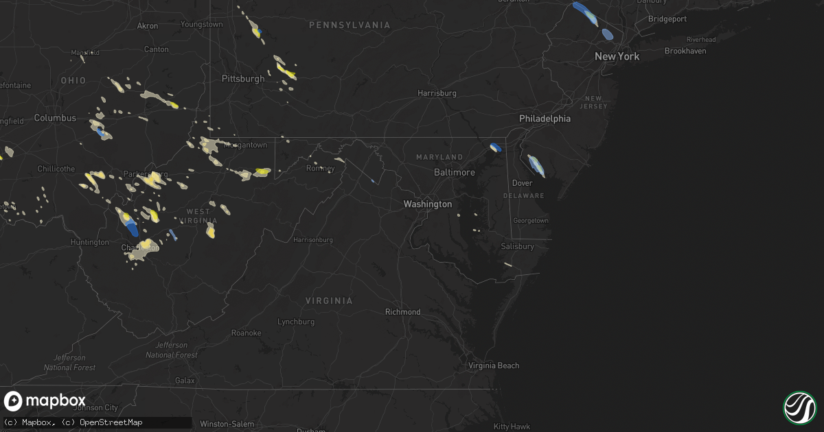
Hail Map in Maryland on August 25, 2020
Get this storm
August 25 map
$229
one time, instant access
Download today. No call, no setup
Keep the $229
Bought the map and want the full workflow? Apply the entire $229 to a subscription within 7 days. None of it is wasted.
Every map, not just this one
This buys you this map. Subscription and you get every map we run, in the markets you choose from a few cities to whole states to nationwide. Plus real-time alerts the moment a storm fires.
Contact data
Name, contact info, occupancy, even credit band for addresses in the footprint. You go from where it hit to who to call.
Become the source they trust
Unlimited branding weather history reports on demand. You already have the documented answer ready for the property owner, and you are the one who showed up with it.
Property data and RoofTrace estimates
Pull up any address you have got, its value and the exact code rules for that jurisdiction, straight from One Click Code. Then RoofTrace estimates the squares, pitch, and roof value, priced the way you price.
Storm reports in Maryland
Maryland
| Date | Description |
|---|---|
| 08/25/20206:43 PM CDT | Tree fell on a house located on pritchard ln |
| 08/25/20205:13 PM CDT | 80 ft walnut tree uprooted in elkmore. Also had pea-sized hail. Time estimated from radar. |
| 08/25/20205:10 PM CDT | A local report indicates 66 MPH wind near 2 E NORTH EAST |
| 08/25/20205:05 PM CDT | Multiple reports of wires and trees down around north east. Time estimated from radar. |
| 08/25/20205:04 PM CDT | Tree and wires down at north east rd. And nazarene camp rd. Time estimated from radar. |
| 08/25/20203:56 PM CDT | Tree down on the 10000 block of mount savage road |
| 08/25/20205:18 AM CDT | At 1017 AM EDT, a severe thunderstorm was located near Paw Paw, moving southeast at 30 mph. HAZARD...60 mph wind gusts and quarter size hail. SOURCE...Radar indicated. IMPACT...Damaging winds will cause some trees and large branches to fall. This could injure those outdoors, as well as damage homes and vehicles. Roadways may become blocked by downed trees. Localized power outages are possible. Unsecured light objects may become projectiles. Locations impacted include... Capon Bridge, Points, Cross Junction, Levels, Higginsville, Gore, Whitacre, Slanesville, Timber Ridge and Bloomery. |
| 08/25/20203:29 AM CDT | At 829 PM EDT, a severe thunderstorm was located 8 miles east of Breezy Point, moving southeast at 30 mph. HAZARD...60 mph wind gusts. SOURCE...Radar indicated. IMPACT...Expect damage to trees and powerlines. This severe thunderstorm will be near, University Of Maryland Center For Environmental Studies around 855 PM EDT. Cambridge around 900 PM EDT.Other locations impacted by this severe thunderstorm include Madison,Brookview, Eldorado, Andrews, Hudson, Church Creek, Lloyds, TaylorsIsland, Woolford and Elliott. |
| 08/25/20203:28 AM CDT | At 828 PM EDT, a severe thunderstorm was located near Tilghman Island, or near Deale, moving southeast at 35 mph. HAZARD...60 mph wind gusts and penny size hail. SOURCE...Radar indicated. IMPACT...Damage to roofs, siding, trees, and power lines is possible. Locations impacted include... Easton, Talbot, Trappe, St. Michaels, Preston, Oxford, Choptank, Tanyard, Tilghman Island, Hambleton and Windyhill. |
| 08/25/20202:51 AM CDT | At 751 PM EDT, severe thunderstorms were located along a line extending from Kettering to Rosaryville to near Fort Washington, moving east at 40 mph. HAZARD...Isolated damaging wind gusts of up to 60 mph. SOURCE...Radar indicated. IMPACT...Damaging winds will cause some trees and large branches to fall. This could injure those outdoors, as well as damage homes and vehicles. Roadways may become blocked by downed trees. Localized power outages are possible. Unsecured light objects may become projectiles. Locations impacted include... Waldorf, Bowie, Clinton, Largo, Mayo, Shady Side, Chesapeake Beach, Deale, Prince Frederick, Upper Marlboro, South River, Breezy Point, Rhode River, Andrews Air Force Base, Kettering, Mitchellville, Rosaryville, Lake Arbor, Marlton and Woodmore. |
| 08/25/20202:36 AM CDT | At 735 PM EDT, severe thunderstorms were located along a line extending from near Lake Ridge to near Dumfries to 8 miles west of Stafford, moving east at 45 mph. HAZARD...60 mph wind gusts. SOURCE...Radar indicated. IMPACT...Damaging winds will cause some trees and large branches to fall. This could injure those outdoors, as well as damage homes and vehicles. Roadways may become blocked by downed trees. Localized power outages are possible. Unsecured light objects may become projectiles. Locations impacted include... Stafford, Waldorf, Dale City, Fredericksburg, La Plata, King George, Woodbridge, Dahlgren, Quantico, Fairview Beach, Nanjemoy Creek, Popes Creek, Aquia Creek, Potomac Creek, Port Tobacco River, Lake Ridge, Montclair, Triangle, Dumfries and Wicomico. |
| 08/25/20202:08 AM CDT | At 708 PM EDT, severe thunderstorms were located along a line extending from Centreville to near Warrenton to near Sperryville, moving southeast at 25 mph. HAZARD...60 mph wind gusts. SOURCE...Radar indicated. IMPACT...Damaging winds will cause some trees and large branches to fall. This could injure those outdoors, as well as damage homes and vehicles. Roadways may become blocked by downed trees. Localized power outages are possible. Unsecured light objects may become projectiles. Locations impacted include... Dale City, Culpeper, Warrenton, Woodbridge, Lake Ridge, Linton Hall, Montclair, Bull Run, Dumfries, Bealeton, Manassas, Sudley, Cherry Hill, Manassas Park, Gainesville, New Baltimore, Independent Hill, Mason Neck, Nokesville and Occoquan. |
| 08/25/20201:31 AM CDT | At 631 PM EDT, a severe thunderstorm was located over Sassafras, or near Middletown, moving southeast at 45 mph. HAZARD...60 mph wind gusts and quarter size hail. SOURCE...Radar indicated. IMPACT...Minor damage to vehicles is possible. Wind damage to roofs, siding, trees, and power lines is possible. Locations impacted include... Dover, Middletown, Smyrna, Clayton, Cheswold, Cecilton, Warwick, Sassafras, Green Spring, Bohemias Mills, Delaney Corner, Dover Speedway, Dover Base Housing, Townsend, Galena, Kenton, Little Creek, Leipsic, Chambersville and Kent Acres. |
| 08/25/202012:50 AM CDT | At 550 PM EDT, a severe thunderstorm was located over Bay View, or 8 miles northeast of Havre De Grace, moving southeast at 30 mph. HAZARD...60 mph wind gusts and quarter size hail. SOURCE...Radar indicated. IMPACT...Minor damage to vehicles is possible. Wind damage to roofs, siding, trees, and power lines is possible. Locations impacted include... Middletown, Elkton, Calvert, North East, Rising Sun, Charlestown, Warwick, Zion, Mount Pleasant, Bohemias Mills, Woodlawn, West Nottingham, Octoraro, Brantwood, Pleasant Hill, Cayots, Bay View, Farmington, Hollywood Beach and Glasgow.This includes Interstate 95 in Maryland between mile markers 92 and106. |
| 08/25/202012:35 AM CDT | At 535 PM EDT, a severe thunderstorm was located over Stanton, or near Newark, moving southeast at 40 mph. HAZARD...60 mph wind gusts and quarter size hail. SOURCE...Radar indicated. IMPACT...Minor damage to vehicles is possible. Wind damage to roofs, siding, trees, and power lines is possible. Locations impacted include... Wilmington, Newark, Pennsville, Carneys Point, Elsmere, New Castle, Salem, Woodstown, Alloway, Quinton, Delaware City, Elmer, Newport, Shiloh, Stanton, North Star, Delaware Memorial Bridge, Hancocks Bridge, Wilmington Manor and Pike Creek.This includes the following highways... New Jersey Turnpike near exit 1. Interstate 95 in Delaware between mile markers 4 and 13. Interstate 295 in New Jersey between mile markers 0 and 4. |
| 08/25/202012:27 AM CDT | At 527 PM EDT, a severe thunderstorm was located 7 miles southeast of Keyser, moving southeast at 30 mph. HAZARD...60 mph wind gusts. SOURCE...Radar indicated. IMPACT...Damaging winds will cause some trees and large branches to fall. This could injure those outdoors, as well as damage homes and vehicles. Roadways may become blocked by downed trees. Localized power outages are possible. Unsecured light objects may become projectiles. Locations impacted include... Keyser, Fort Ashby, Piedmont, Burlington, Luke, Russelldale, Headsville, Short Gap, New Creek, Wagoner, Antioch, Reeses Mill, Ridgeville and Mccoole. |
| 08/25/202012:24 AM CDT | At 524 PM EDT, severe thunderstorms were located along a line extending from 7 miles west of Martinsburg to near Greenwood, moving southeast at 35 mph. HAZARD...60 mph wind gusts and quarter size hail. SOURCE...Radar indicated. IMPACT...Damaging winds will cause some trees and large branches to fall. This could injure those outdoors, as well as damage homes and vehicles. Roadways may become blocked by downed trees. Localized power outages are possible. Unsecured light objects may become projectiles. Locations impacted include... Martinsburg, Charles Town, Greenwood, Ranson, Inwood, Harpers Ferry, Kearneysville, Corporation Of Ranson, Bolivar, Shenandoah Junction, Middleway, Winebrenners Cross, Cedar Grove, Clear Brook, Ridgeway, Bunker Hill, Stephenson, Arden, Cedar Hill and Jones Springs. |
| 08/25/202012:19 AM CDT | At 518 PM EDT, severe thunderstorms were located along a line extending from near Paw Paw to 7 miles east of Westernport to near Keyser, moving southeast at 25 mph. HAZARD...60 mph wind gusts. SOURCE...Radar indicated. IMPACT...Damaging winds will cause some trees and large branches to fall. This could injure those outdoors, as well as damage homes and vehicles. Roadways may become blocked by downed trees. Localized power outages are possible. Unsecured light objects may become projectiles. Locations impacted include... Romney, Springfield, Green Spring, Augusta, Shanks, Purgitsville, Three Churches, Frenchburg, Higginsville, Slanesville, Bloomery, Points, Largent, Levels, Junction and Wapocomo. |
| 08/25/202012:03 AM CDT | At 502 PM EDT, a severe thunderstorm was located 8 miles northwest of Parsons, moving southeast at 25 mph. HAZARD...Wind gusts to 60 mph. SOURCE...Radar. IMPACT...Expect damage to trees and power lines, resulting in some power outages. Locations impacted include... Parsons... Davis... Thomas... Hendricks... Hambleton... Hannahsville... Benbush... Elk... Lead Mine... Pifer Moutain... Canaan Valley State Park... Pheasant Run... |
| 08/24/202011:52 PM CDT | At 451 PM EDT, a severe thunderstorm was located near Bittinger, moving southeast at 30 mph. HAZARD...60 mph wind gusts. SOURCE...Radar indicated. IMPACT...Damaging winds will cause some trees and large branches to fall. This could injure those outdoors, as well as damage homes and vehicles. Roadways may become blocked by downed trees. Localized power outages are possible. Unsecured light objects may become projectiles. Locations impacted include... Cumberland, Frostburg, Keyser, Westernport, Bel Air, La Vale, Fort Ashby, Lonaconing, Piedmont, Cresaptown, Potomac Park, Wiley Ford, Eckhart Mines, Rawlings, Barton, Midland, Midlothian, Franklin, Burlington and Woodland. |
| 08/24/202011:50 PM CDT | At 450 PM EDT, severe thunderstorms were located along a line extending from near Berkeley Springs to 7 miles east of Cumberland, moving southeast at 60 mph. HAZARD...60 mph wind gusts and quarter size hail. SOURCE...Radar indicated. IMPACT...Damaging winds will cause some trees and large branches to fall. This could injure those outdoors, as well as damage homes and vehicles. Roadways may become blocked by downed trees. Localized power outages are possible. Unsecured light objects may become projectiles. Locations impacted include... Martinsburg, Charles Town, Shepherdstown, Paw Paw, Greenwood, Ranson, Inwood, Berkeley Springs, Corporation Of Ranson, Kearneysville, Berkeley, Shenandoah Junction, Middleway, Great Cacapon, Hedgesville, Little Orleans, Winebrenners Cross, Johnsontown, Valley View and Ridgeway. |
| 08/24/202011:21 PM CDT | At 421 PM EDT, severe thunderstorms were located along a line extending from near New Stanton to near Acosta, moving east at 25 mph. HAZARD...60 mph wind gusts and quarter size hail. SOURCE...Radar indicated. IMPACT...Hail damage to vehicles is expected. Expect wind damage to trees, roofs, and siding. Locations impacted include... Somerset, Meyersdale, Berlin, Friedens, Acosta, Ursina, New Centerville, Mount Davis, Rockwood, Confluence, Salisbury, Garrett, Indian Lake, Shanksville, Addison, Wellersburg, New Baltimore, Casselman, Callimont and Seven Springs.This includes The Pennsylvania Turnpike from mile markers 100 to 129. |
| 08/24/202011:20 PM CDT | At 420 PM EDT, a severe thunderstorm was located near Cassville, or 10 miles north of Fairmont, moving southeast at 40 mph. HAZARD...Wind gusts to 60 mph and quarter-size hail. SOURCE...Radar. IMPACT...Minor hail damage to vehicles is possible. Expect wind damage to trees and power lines, resulting in some power outages. Locations impacted include... Morgantown... Fairmont... Westover... Kingwood... Mannington... Star City... Terra Alta... Rowlesburg... Pleasant Valley... Winfield... Barrackville... Point Marion...This includes the following highways... Interstate 68 in West Virginia between mile markers 1 and 31. Interstate 79 in Pennsylvania between mile markers 0 and 6. Interstate 79 in West Virginia between mile markers 130 and 160. |
| 08/24/202011:12 PM CDT | At 411 PM EDT, a severe thunderstorm was located near Lake Gordon, or 13 miles north of Cumberland, moving southeast at 30 mph. HAZARD...60 mph wind gusts and quarter size hail. SOURCE...Radar indicated. IMPACT...Damaging winds will cause some trees and large branches to fall. This could injure those outdoors, as well as damage homes and vehicles. Roadways may become blocked by downed trees. Localized power outages are possible. Unsecured light objects may become projectiles. Locations impacted include... Cumberland, Hancock, Paw Paw, Berkeley Springs, Ellerslie, Corriganville, Great Cacapon, Flintstone, Pecktonville, Little Orleans, Johnsons Mill, Valley View, Spohrs Crossroads, Fishers Bridge, Pumpkin Center, Oakland, Rock Gap, Wolfe Mill, Smith Crossroads and New Hope. |
| 08/24/202010:49 PM CDT | At 348 PM EDT, a severe thunderstorm was located near Central City, moving southeast at 50 mph. HAZARD...60 mph wind gusts and quarter size hail. SOURCE...Radar indicated. IMPACT...Hail damage to vehicles is expected. Expect wind damage to trees, roofs, and siding. Locations impacted include... Bedford, Clearville, Everett, Buffalo Mills, Cessna, Inglesmith, Schellsburg, Manns Choice, New Paris and Rainsburg.This includes the following Interstates... The Pennsylvania Turnpike from mile markers 130 to 157. Interstate 99 from mile markers 0 to 3. |
| 08/24/20209:26 PM CDT | At 226 PM EDT, a severe thunderstorm was located 8 miles east of Point Marion, or 11 miles east of Morgantown, moving east at 25 mph. HAZARD...Wind gusts to 60 mph. SOURCE...Radar. IMPACT...Expect damage to trees and power lines, resulting in some power outages. Locations impacted include... Friendsville... Accident... Markleysburg... Brandonville... Bruceton Mills... Laurel Run... Hazelton... Clifton Mills... Mineral Spring... McHenry... Selbysport... Cranesville...This includes the following highways... Interstate 68 in Maryland between mile markers 1 and 10. Interstate 68 in West Virginia between mile markers 12 and 32. |
| 08/24/20208:55 PM CDT | Tree down near the intersection of route 13 and stewart neck road. Time estimated from radar data. |
| 08/24/20208:30 PM CDT | Tree down. Time estimated from radar data. |
| 08/24/20208:14 PM CDT | Report of a tree blown down in denton. Time estimated from radar. |
| 08/24/20207:25 PM CDT | A local report indicates 72 MPH wind near 3 S GRASONVILLE |
All States Impacted by Hail Map on August 25, 2020
Cities Impacted by Hail Map on August 25, 2020
- Dexter, ME
- Saint Clairsville, OH
- Middletown, OH
- Mass City, MI
- Fresno, OH
- Coshocton, OH
- Ford City, PA
- Bradley, ME
- Newark, OH
- Heath, OH
- Blairsville, PA
- Apollo, PA
- Procious, WV
- Clendenin, WV
- West Union, OH
- Winchester, OH
- Newport, NJ
- Bloomery, WV
- Paw Paw, WV
- Slanesville, WV
- Ripley, OH
- Mesick, MI
- Keyser, WV
- Pelkie, MI
- Onekama, MI
- Bear Lake, MI
- Tracys Landing, MD
- Wautoma, WI
- Neshkoro, WI
- Redgranite, WI
- Berlin, WI
- Markesan, WI
- Brandon, WI
- Princeton, WI
- Green Lake, WI
- Ripon, WI
- Elkview, WV
- Charleston, WV
- Accident, MD
- Parkersburg, WV
- Davisville, WV
- Walker, WV
- Waverly, WV
- Gandeeville, WV
- Spencer, WV
- Athens, OH
- Albany, OH
- New Marshfield, OH
- Hope, ME
- Thomaston, ME
- Metamora, IN
- Connersville, IN
- Laurel, IN
- Brookville, IN
- Portland, OH
- Racine, OH
- South Charleston, WV
- Old Town, ME
- Bangor, ME
- Orono, ME
- Elizabeth, WV
- Mineral Wells, WV
- Waynesburg, PA
- Mount Morris, PA
- Honor, MI
- Beulah, MI
- Frankfort, MI
- Benzonia, MI
- Wellston, OH
- Webster Springs, WV
- Westover, MD
- Princess Anne, MD
- Hamden, OH
- McArthur, OH
- Ellsworth, ME
- Orland, ME
- Clarksburg, PA
- Avonmore, PA
- Saltsburg, PA
- Randolph, WI
- Fall River, WI
- Hart, MI
- Hesperia, MI
- Walkerville, MI
- Harrisville, WV
- Berea, WV
- Josephine, PA
- Black Lick, PA
- Wilmington, OH
- Wilkesville, OH
- Waupun, WI
- Fairwater, WI
- Pine River, WI
- Mount Desert, ME
- Bar Harbor, ME
- Highland Lakes, NJ
- Glenwood, NJ
- Vernon, NJ
- Hewitt, NJ
- West Milford, NJ
- Greenwich, NJ
- Bridgeton, NJ
- Cedarville, NJ
- Newaygo, MI
- Shelocta, PA
- Spring Church, PA
- Nisula, MI
- Ontonagon, MI
- Belmont, OH
- Flushing, OH
- Bethesda, OH
- Piedmont, OH
- Freeport, OH
- Millersburg, OH
- Gowen, MI
- Cedar Springs, MI
- Greenville, MI
- Hawley, MN
- Leon, WV
- Sand Lake, MI
- Wisconsin Dells, WI
- Oxford, WI
- Sardinia, OH
- Russellville, OH
- Georgetown, OH
- Rio, WI
- Portage, WI
- Cambria, WI
- Pardeeville, WI
- Montello, WI
- Ludington, MI
- Pentwater, MI
- Blount, WV
- Hernshaw, WV
- Alum Creek, WV
- Ridgeview, WV
- Tad, WV
- Nellis, WV
- Tornado, WV
- Sod, WV
- Belle, WV
- Ashford, WV
- Cambridge, MD
- Belleville, WV
- Lumberport, WV
- New Freeport, PA
- Holbrook, PA
- Kaleva, MI
- Manistee, MI
- Arcadia, MI
- Cincinnati, OH
- Hebron, KY
- Washington, WV
- Petroleum, WV
- Duck, WV
- Frametown, WV
- Somerset, OH
- New Lexington, OH
- Rivesville, WV
- Maidsville, WV
- Morgantown, WV
- Guysville, OH
- Lake George, MN
- Park Rapids, MN
- Clarksville, OH
- Grand Marsh, WI
- West Union, WV
- Littleton, WV
- Warsaw, OH
- Chicora, PA
- Petrolia, PA
- Karns City, PA
- Colfax, ND
- Walcott, ND
- Champion, MI
- Otway, OH
- Lucasville, OH
- Aberdeen, OH
- Lyndon Station, WI
- Eddington, ME
- New Martinsville, WV
- Enon, OH
- Medway, OH
- Yellow Springs, OH
- Fairborn, OH
- Port Deposit, MD
- Charlestown, MD
- North East, MD
- Saint Michaels, MD
- Bozman, MD
- Wittman, MD
- Parsons, WV
- Aurora, WV
- Rowlesburg, WV
- Terra Alta, WV
- Stoneboro, PA
- Jackson Center, PA
- Le Roy, WV
- Reedy, WV
- Palestine, WV
- Wahpeton, ND
- Garnett, SC
- Moatsville, WV
- Philippi, WV
- Grafton, WV
- Thornton, WV
- Milford, ME
- Jamestown, OH
- Port William, OH
- Sabina, OH
- Bancroft, WI
- Dalton, WI
- Endeavor, WI
- Genoa, NY
- Groton, NY
- Locke, NY
- Lansing, NY
- King Ferry, NY
- Ripley, WV
- Mauston, WI
- Copemish, MI
- Thompsonville, MI
- Export, PA
- Oregonia, OH
- Fremont, MI
- Deeth, NV
- Rogerson, ID
- Jackpot, NV
- Peebles, OH
- Piketon, OH
- Wisconsin Rapids, WI
- Mansfield, OH
- Rockland, ME
- Owls Head, ME
- Brownsville, IN
- Liberty, IN
- Frazeysburg, OH
- Blanchester, OH
- Fayetteville, OH
- White Pine, MI
- New Alexandria, PA
- North Haven, ME
- West Chester, OH
- Hamilton, OH
- French Creek, WV
- Michigamme, MI
- Erbacon, WV
- Cowen, WV
- Diana, WV
- Paris, MI
- Rodney, MI
- Big Rapids, MI
- Plainfield, WI
- Ligonier, PA
- Bolivar, PA
- Proctor, WV
- Clarksburg, WV
- Mannington, WV
- Smithfield, WV
- Folsom, WV
- Wallace, WV
- Shinnston, WV
- Peytona, WV
- Sussex, NJ
- Ringwood, NJ
- Bloomingdale, NJ
- Wanaque, NJ
- Lanse, MI
- Mount Orab, OH
- Creston, WV
- Hilliards, PA
- Harrisville, PA
- West Sunbury, PA
- Parker, PA
- Boyers, PA
- Cairo, WV
- Ravenswood, WV
- Long Bottom, OH
- New Lisbon, WI
- Lebanon, OH
- Mason, OH
- Lafayette, IN
- Zanesville, OH
- Lidgerwood, ND
- Wyndmere, ND
- Bridgeport, WV
- Flemington, WV
- Orr, MN
- Burton, WV
- Fairview, WV
- Hundred, WV
- Metz, WV
- Cameron, WV
- Wana, WV
- Pine Grove, WV
- Jacksonburg, WV
- Zaleski, OH
- Vinton, OH
- Langsville, OH
- Thornville, OH
- Glenford, OH
- New Carlisle, OH
- Pennsboro, WV
- Rockport, WV
- Moundsville, WV
- Callaway, MN
- Kenduskeag, ME
- Hudson, ME
- Chase, MI
- Reed City, MI
- Walton, WV
- Gay, WV
- Huger, SC
- Fox Lake, WI
- Rarden, OH
- Boyce, VA
- Homer City, PA
- Mount Perry, OH
- Wind Ridge, PA
- Aleppo, PA
- Romney, WV
- Tippecanoe, OH
- Pickett, WI
- Laporte, MN
- Galion, OH
- East Brady, PA
- Worthington, PA
- New Florence, PA
- Hibbing, MN
- Rushville, IN
- Newcomerstown, OH
- Stone Creek, OH
- Reedsville, OH
- Clarks Hill, IN
- Surry, ME
- Oakland, MD
- Rock Cave, WV
- Crawford, WV
- Tallmansville, WV
- Port Washington, OH
- Kimbolton, OH
- Auburn, WV
- Perryville, MD
- Morrow, OH
- Brinkhaven, OH
- Augusta, WV
- Stout, OH
- Bucksport, ME
- Foster, WV
- Burlington, WV
- Senecaville, OH
- Byesville, OH
- New Concord, OH
- Cambridge, OH
- Julian, WV
- Given, WV
- Kenna, WV
- Point Pleasant, WV
- Buffalo, WV
- Southside, WV
- Liberty, WV
- Letart, WV
- Bellville, OH
- Orma, WV
- Lancaster, OH
- Pineland, SC
- Mecosta, MI
- Kindred, ND
- Port Edwards, WI
- Clay, WV
- Bomont, WV
- Brooksville, KY
- Lake Park, MN
- Briggsville, WI
- Friesland, WI
- Middleburg, VA
- Dallas, WV
- Crooksville, OH
- Junction City, OH
- Hebron, OH
- Rushville, OH
- Fortescue, NJ
- Salem, NJ
- Camden, OH
- Newfoundland, NJ
- Latrobe, PA
- Stahlstown, PA
- Addison, PA
- Reader, WV
- Smithville, WV
- Pullman, WV
- Hankinson, ND
- Derry, PA
- Grove City, PA
- Lincolnville, ME
- Monroe, OH
- Nashport, OH
- Warren, ME
- Hannibal, OH
- Sardis, OH
- Paden City, WV
- Clarington, OH
- Gardiner, ME
- Rockport, ME
- Walkersville, WV
- Exeter, RI
- Bidwell, OH
- Norwich, OH
- Indiana, PA
- Cheshire, OH
- Blissfield, OH
- Killbuck, OH
- Berryville, VA
- Summit Point, WV
- Elkton, MD
- Rising Sun, MD
- Springfield, OH
- Warwick, NY
- Shiloh, NJ
- Freeville, NY
- Dryden, NY
- Wappingers Falls, NY
- Putnam Valley, NY
- Fishkill, NY
- Beacon, NY
- Cold Spring, NY
- Hopewell Junction, NY
- Laurens, NY
- Otego, NY
- Oneonta, NY
- West Oneonta, NY
- Coral, PA
- Evans, WV
- Tunnelton, WV
- Coventry, CT
- North Windham, CT
- Hampton, CT
- Moosup, CT
- Chaplin, CT
- Brooklyn, CT
- Mansfield Center, CT
- Storrs Mansfield, CT
- Windham, CT
- Plainfield, CT
- Canterbury, CT
- Waldwick, NJ
- Oakland, NJ
- Haledon, NJ
- Midland Park, NJ
- Ho Ho Kus, NJ
- Glen Rock, NJ
- Paterson, NJ
- Allendale, NJ
- Wyckoff, NJ
- Ridgewood, NJ
- Fair Lawn, NJ
- Franklin Lakes, NJ
- Hawthorne, NJ
- Mahwah, NJ
- Saddle Brook, NJ
- Wayne, NJ
- Paramus, NJ
- Elmwood Park, NJ
- Port Jervis, NY
- Pine Island, NY
- Unionville, NY
- Westtown, NY
- Montague, NJ
- Matamoras, PA
- Baraga, MI
- Poland, ME
- Mechanic Falls, ME
- Clinton, ME
- Newton, WV
- Wallback, WV
- Maysel, WV
- Red House, WV
- Poca, WV


