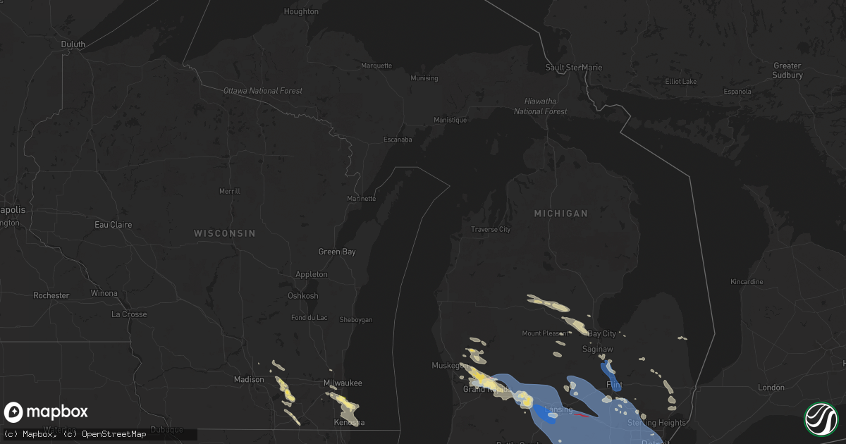
Hail Map in Michigan on August 24, 2023
Get this storm
August 24 map
$229
one time, instant access
Download today. No call, no setup
Keep the $229
Bought the map and want the full workflow? Apply the entire $229 to a subscription within 7 days. None of it is wasted.
Every map, not just this one
This buys you this map. Subscription and you get every map we run, in the markets you choose from a few cities to whole states to nationwide. Plus real-time alerts the moment a storm fires.
Contact data
Name, contact info, occupancy, even credit band for addresses in the footprint. You go from where it hit to who to call.
Become the source they trust
Unlimited branding weather history reports on demand. You already have the documented answer ready for the property owner, and you are the one who showed up with it.
Property data and RoofTrace estimates
Pull up any address you have got, its value and the exact code rules for that jurisdiction, straight from One Click Code. Then RoofTrace estimates the squares, pitch, and roof value, priced the way you price.
Storm reports in Michigan
Michigan
| Date | Description |
|---|---|
| 08/23/20239:45 PM CDT | Numerous trees reported down across gibraltar... Mainly focused over the southern part of the city. |
| 08/23/20239:43 PM CDT | Confirmed ef-1 tornado with maximum winds of 90 mph and a path of 1.4 miles. |
| 08/23/20239:42 PM CDT | Photos of large trees down sent in. |
| 08/23/20239:42 PM CDT | Received multiple reports of damage to a mobile home park in frenchtown township. Social media photos show mobile home knocked off foundation. |
| 08/23/20239:39 PM CDT | Photos of trees down sent in via facebook. |
| 08/23/20239:39 PM CDT | Confirmed ef-1 tornado in south rockwood with maximum winds of 105 mph and a path length of 5.4 miles. |
| 08/23/20239:38 PM CDT | A weak tornado touched down in a farm field in ash township north of newport road and half a mile west of north telegraph road. The tornado tracked southeast and hit fr |
| 08/23/20239:33 PM CDT | Measured at detroit metro airport. |
| 08/23/20239:30 PM CDT | Reported on the west side of detroit... Near the intersection of evergreen and joy. |
| 08/23/20239:24 PM CDT | Social media photos received of large downed limb. Public described tree as being cracked in half. |
| 08/23/20239:23 PM CDT | The weak tornado touched down near the wagner homestead farm with mainly leaf and twigs blown down. The tornado tracked southeast and crossed elwell road near belmont d |
| 08/23/20239:22 PM CDT | Multiple trees uprooted... Shingles off roofs. |
| 08/23/20239:21 PM CDT | Dispatch reports trees and power lines down across the county. Numerous reports came from around clinton township. |
| 08/23/20239:20 PM CDT | Large tree blown onto road. |
| 08/23/20239:20 PM CDT | Social media photos of large tree branches down at 7 mile and beech. |
| 08/23/20239:20 PM CDT | Measured via anemometer. Corrected time. |
| 08/23/20239:20 PM CDT | 25 foot pine tree was uprooted and landed on neighbor's roof in neighborhood near sheldon rd and palmer rd. |
| 08/23/20239:19 PM CDT | The weak tornado touched down just northwest of pheasant run golf course and track southeast. Dozens of thrrees were downed and uprooted. The tornado continued southeas |
| 08/23/20239:15 PM CDT | Trees and power lines reported down across salem |
| 08/23/20239:10 PM CDT | 1 foot diameter tree reported down. |
| 08/23/20239:10 PM CDT | Spotter reported large trees down on cars... Streets impassable around hiscock st and daniel st. |
| 08/23/20239:07 PM CDT | A local report indicates 64 MPH wind near 3 E Sandstone |
| 08/23/20239:07 PM CDT | Spotter reports healthy 8 inch limb down in backyard. Numerous smaller limbs down around neighborhood. |
| 08/23/20239:05 PM CDT | Trees reported down across green oak township. |
| 08/23/20239:00 PM CDT | Trees reported down at pleasant valley and spencer roads |
| 08/23/20238:46 PM CDT | Numerous trees and tree limbs downed from wet microburst. Estimated winds of 65 mph. |
| 08/23/20238:45 PM CDT | Trees reported down in multiple spots in argentine. |
| 08/23/20238:45 PM CDT | Trees and power lines were reported down across the county. |
| 08/23/20238:44 PM CDT | Public reports multiple 6 to 12 inch diameter limbs down south of fowlerville at nicholson road between grand river and van orden via social media. |
| 08/23/20238:41 PM CDT | Near fenton rd and north long lake rd... 6 inch diameter tree branches down in the road. |
| 08/23/20238:41 PM CDT | A confirmed tornado... Causing ef1 damage with winds up to 90 mph entered livingston county near west branch red cedar river... Crossing wallace rd. Tornado tracked clo |
| 08/23/20238:40 PM CDT | Many trees snapped and uprooted due to straight line winds from wallace road to cedar road... Along and north of west van orgen rd. Estimated wind speeds up to 90 mph. |
| 08/23/20238:40 PM CDT | Marengo twp. Fire reports multiple large trees down. Time estimated via radar. |
| 08/23/20238:35 PM CDT | A local report indicates 61 MPH wind near 2 SE Mason |
| 08/23/20238:35 PM CDT | Multiple trees and limbs down across leslie. Time estimated via radar. |
| 08/23/20238:35 PM CDT | Multiple cars flipped over on i-96. Possible tornado. |
| 08/23/20238:35 PM CDT | Roof collapse of a building. Possible tornado. |
| 08/23/20238:29 PM CDT | *** 1 fatal... 3 inj *** ef-2 tornado in ingham county that moved into livingston county. Path in ingham county around 10.70 miles. Total path 12.00 miles. Estimated ma |
| 08/23/20238:28 PM CDT | Several large trees down damaging a chicken coop. Time estimated via radar. |
| 08/23/20238:22 PM CDT | Multiple large trees down in okemos. Time estimated via radar. |
| 08/23/20238:21 PM CDT | A local report indicates 71 MPH wind near 2 N Edgemont Park |
| 08/23/20238:20 PM CDT | Measured via anemometer. |
| 08/23/20238:17 PM CDT | A local report indicates 70 MPH wind near 2 N Charlotte |
| 08/23/20238:15 PM CDT | Multiple 4 inch diameter healthy branches down. Time estimated via radar. |
| 08/23/20238:15 PM CDT | Multiple large branches down in colonial village neighborhood. Time estimated via radar. |
| 08/23/20238:15 PM CDT | Multiple trees uprooted onto homes in the windsor estates mobile home park. |
| 08/23/20238:12 PM CDT | Trees and limbs down across potterville. Time estimated via radar. |
| 08/23/20238:11 PM CDT | Multiple trees and limbs down. |
| 08/23/20238:10 PM CDT | Large tree down across nixon rd. Numerous wires and large branches down. Time estimated via radar. |
| 08/23/20238:10 PM CDT | City of grand ledge reports numerous wires and trees down across the city. Time estimated via radar. |
| 08/23/20238:10 PM CDT | Numerous trees and limbs down in saint johns. Time estimated via radar. |
| 08/23/20238:10 PM CDT | Two to four inch limbs down. |
| 08/23/20237:50 PM CDT | Multiple trees damaged between peake rd. And butler rd. Time estimated via radar. |
| 08/23/20237:45 PM CDT | Over 30 pine trees down at morrison lake golf course. Time estimated via radar. |
| 08/23/20237:35 PM CDT | Several large trees down. |
| 08/23/20237:35 PM CDT | Multiple large trees down. |
| 08/23/20237:34 PM CDT | Numerous trees down across foreman st. Time estimated via radar. |
| 08/23/20237:34 PM CDT | Tree down across gavin lake road a few hundred feet south of m44. Time estimated from radar. |
| 08/23/20237:34 PM CDT | Multiple trees down on arrowhead gold course. Time estimated via radar. |
| 08/23/20237:30 PM CDT | A local report indicates 60 MPH wind near 1 WNW Comstock Park |
| 08/23/20237:21 PM CDT | Tree on house. Possible tornado. Radar showed debris signature in this area. |
| 08/23/20237:20 PM CDT | Roof off of well built home. Camper flipped. Numerous homes with window and siding damage in scotview dr. Neighborhood. Possible tornado. Time estimated via radar. |
| 08/23/20237:18 PM CDT | Trees across m37 at 7 mile. Possible tornado. Possible damage to structures. Time estimated from radar. |
| 08/23/20237:17 PM CDT | Multiple large trees down. Time estimated via radar. |
| 08/23/20237:15 PM CDT | Path length 8.7 miles. Path width 100 yards. Maximum estimated windspeed 110 mph. |
| 08/23/20237:03 PM CDT | Multiple large branches down. Time estimated via radar. |
All States Impacted by Hail Map on August 24, 2023
Cities Impacted by Hail Map on August 24, 2023
- Williamstown, KY
- Dry Ridge, KY
- Lancaster, KY
- Stanford, KY
- Bottineau, ND
- Norwich, ND
- Surrey, ND
- Deering, ND
- Granville, ND
- Bantry, ND
- Killdeer, ND
- Halliday, ND
- Dunn Center, ND
- Garrison, ND
- Beulah, ND
- Towner, ND
- Piedmont, SD
- Black Hawk, SD
- Franklin, WI
- Oak Creek, WI
- Rapid City, SD
- Caledonia, WI
- Franksville, WI
- Racine, WI
- Lake Mills, WI
- Jefferson, WI
- Plaucheville, LA
- Simmesport, LA
- Murrayville, GA
- Chickamauga, GA
- Flintstone, GA
- Saint Francisville, LA
- Centreville, MS
- Trenton, GA
- Vinton, LA
- Sulphur, LA
- Mountain Rest, SC
- Clarkesville, GA
- Mount Airy, GA
- Sturgis, SD
- Reeves, LA
- Glenburn, ND
- Nemo, SD
- Cornelia, GA
- Rising Fawn, GA
- Flat Rock, AL
- Westminster, SC
- Walhalla, SC
- New Town, ND
- Parshall, ND
- Merriman, NE
- Muskego, WI
- Minot, ND
- Natchez, MS
- Woodville, MS
- Baldwin, GA
- Homer, GA
- Carnesville, GA
- Rocky Mount, VA
- Kramer, ND
- Souris, ND
- Reeseville, WI
- Waterloo, WI
- Columbus, WI
- Sun Prairie, WI
- Deforest, WI
- Ragley, LA
- Longville, LA
- Willow City, ND
- Upham, ND
- Brevard, NC
- Urbana, MO
- Pickens, SC
- Hattieville, AR
- Solgohachia, AR
- Cleveland, AR
- Center Ridge, AR
- Batchelor, LA
- Lettsworth, LA
- Melville, LA
- Berthold, ND
- Milwaukee, WI
- New Berlin, WI
- Cleveland, GA
- Clermont, GA
- Lula, GA
- Hazen, ND
- New Salem, ND
- Glen Ullin, ND
- Stanton, ND
- Center, ND
- Fort Atkinson, WI
- Whitewater, WI
- Mandan, ND
- Gordon, NE
- Bismarck, ND
- Baldwin, ND
- Coopersville, MI
- Marne, MI
- Grand Rapids, MI
- Comstock Park, MI
- Belmont, MI
- Ada, MI
- Rockford, MI
- Belding, MI
- Lowell, MI
- Greenville, MI
- Clarksville, MI
- Saranac, MI
- Lake Odessa, MI
- Ionia, MI
- Cody, NE
- Birch Run, MI
- Clio, MI
- Montrose, MI
- Burt, MI
- Mount Morris, MI
- Flushing, MI
- Flint, MI
- Burton, MI
- Portland, MI
- Sunfield, MI
- Lyons, MI
- Mulliken, MI
- Vermontville, MI
- Charlotte, MI
- Lansing, MI
- Grand Ledge, MI
- Eagle, MI
- Potterville, MI
- Dimondale, MI
- Dewitt, MI
- Westphalia, MI
- Bath, MI
- Muir, MI
- Pewamo, MI
- Saint Johns, MI
- Fowler, MI
- Eaton Rapids, MI
- Holt, MI
- Fowlerville, MI
- Okemos, MI
- Haslett, MI
- Mason, MI
- Webberville, MI
- Williamston, MI
- Dansville, MI
- East Lansing, MI
- Grand Blanc, MI
- Elsie, MI
- Owosso, MI
- Henderson, MI
- Ovid, MI
- Laingsburg, MI
- Morrice, MI
- Perry, MI
- Bancroft, MI
- Vernon, MI
- Lennon, MI
- Corunna, MI
- Durand, MI
- Byron, MI
- Howell, MI
- Linden, MI
- Swartz Creek, MI
- Gaines, MI
- Springport, MI
- Onondaga, MI
- Leslie, MI
- Jackson, MI
- Albion, MI
- Rives Junction, MI
- Parma, MI
- Gregory, MI
- Pleasant Lake, MI
- Munith, MI
- Stockbridge, MI
- Fenton, MI
- Pinckney, MI
- Hartland, MI
- Davisburg, MI
- Holly, MI
- Grass Lake, MI
- Brighton, MI
- Dexter, MI
- Chelsea, MI
- Highland, MI
- South Lyon, MI
- Milford, MI
- Michigan Center, MI
- Hamburg, MI
- Ann Arbor, MI
- Whitmore Lake, MI
- Clarkston, MI
- New Hudson, MI
- Ortonville, MI
- White Lake, MI
- Walled Lake, MI
- Wixom, MI
- Plymouth, MI
- Northville, MI
- Commerce Township, MI
- Novi, MI
- Waterford, MI
- West Bloomfield, MI
- Farmington, MI
- Keego Harbor, MI
- Bloomfield Hills, MI
- Pontiac, MI
- Auburn Hills, MI
- Berkley, MI
- Birmingham, MI
- Livonia, MI
- Redford, MI
- Oak Park, MI
- Franklin, MI
- Southfield, MI
- Canton, MI
- Detroit, MI
- Westland, MI
- Ferndale, MI
- Dearborn Heights, MI
- Highland Park, MI
- Inkster, MI
- Hamtramck, MI
- Dearborn, MI
- Garden City, MI
- Taylor, MI
- Belleville, MI
- Allen Park, MI
- Wayne, MI
- Romulus, MI
- Melvindale, MI
- Brooklyn, MI
- Manchester, MI
- Norvell, MI
- Clinton, MI
- Napoleon, MI
- Saline, MI
- Tecumseh, MI
- Maybee, MI
- Carleton, MI
- Britton, MI
- Newport, MI
- Milan, MI
- Willis, MI
- Ypsilanti, MI
- River Rouge, MI
- Trenton, MI
- Riverview, MI
- Wyandotte, MI
- Tipton, MI
- Flat Rock, MI
- Southgate, MI
- Lincoln Park, MI
- Ecorse, MI
- New Boston, MI
- Madison Heights, MI
- Hazel Park, MI
- Warren, MI
- Royal Oak, MI
- Pleasant Ridge, MI
- Huntington Woods, MI
- Dundee, MI
- Temperance, MI
- Deerfield, MI
- Petersburg, MI
- South Rockwood, MI
- Grosse Ile, MI
- Rockwood, MI
- Ida, MI
- Monroe, MI
- Ottawa Lake, MI
- Erie, MI
- Luna Pier, MI
- Lambertville, MI
- Riga, MI
- La Salle, MI
- Toledo, OH
- Blissfield, MI
- Rossford, OH
- Sylvania, OH
- Oregon, OH
- Curtice, OH
- Northwood, OH
- Harbor View, OH
- Clay Center, OH
- Walbridge, OH
- Graytown, OH
- Millbury, OH
- Williston, OH
- Lindsey, OH
- Martin, OH
- Fremont, OH
- Elmore, OH
- Genoa, OH
- Rocky Ridge, OH
- Oak Harbor, OH
- Port Clinton, OH
- Lacarne, OH
- Woodville, OH
- Put In Bay, OH
- Middle Bass, OH
- Isle Saint George, OH
- Sandusky, OH
- Kelleys Island, OH
- Vickery, OH
- Castalia, OH
- Clyde, OH
- Lakeside Marblehead, OH
- Bellevue, OH
- Milan, OH
- Norwalk, OH
- Monroeville, OH
- Gibsonburg, OH
- Perrysburg, OH
- Huron, OH
- Lorain, OH
- Vermilion, OH
- Collins, OH
- Berlin Heights, OH
- Amherst, OH
- Sheffield Lake, OH
- Wakeman, OH
- Oberlin, OH
- Avon Lake, OH
- Elyria, OH
- Berea, OH
- Lakewood, OH
- Grand River, OH
- Eastlake, OH
- Painesville, OH
- Independence, OH
- Strongsville, OH
- Beachwood, OH
- Perry, OH
- Columbia Station, OH
- North Olmsted, OH
- Westlake, OH
- Chesterland, OH
- Gates Mills, OH
- Euclid, OH
- North Ridgeville, OH
- Willoughby, OH
- Mentor, OH
- Bay Village, OH
- Avon, OH
- Brookpark, OH
- Cleveland, OH
- Wickliffe, OH
- Olmsted Falls, OH
- Rocky River, OH
- Grafton, OH
- North Royalton, OH
- Brunswick, OH
- Chardon, OH
- Broadview Heights, OH
- Akron, MI
- Grant, MI
- Twin Lake, MI
- Linwood, MI
- Pinconning, MI
- Atkins, AR
- Bailey, MI
- Fremont, MI
- Allen, SD
- Eunice, LA
- Basile, LA
- Iota, LA
- Harvey, ND
- North Branch, MI
- Imlay City, MI
- Brown City, MI
- Newaygo, MI
- Delavan, WI
- Yale, MI
- Whitman, NE
- Valentine, NE
- Walworth, WI
- Shepherd, MI
- Salisbury, NC
- Raymond, MS
- Terry, MS
- White Cloud, MI
- Deckerville, MI
- Casnovia, MI
- Kent City, MI
- Prairie City, SD
- Reva, SD
- Esmond, ND
- Maddock, ND
- Milton, WI
- Hot Springs National Park, AR
- Interior, SD
- Wanblee, SD
- Devils Lake, ND
- Saint Michael, ND
- Oberon, ND
- Decatur, MI
- Grayson, GA
- Snellville, GA
- Loganville, GA
- Watertown, WI
- Bridgeport, MI
- Saginaw, MI
- Kountze, TX
- Nunica, MI
- Silsbee, TX
- Lodgepole, SD
- Conklin, MI
- New Haven, MI
- Richmond, MI
- Roxie, MS
- Big Bend, WI
- Martin, SD
- Harrison, MI
- Utica, MS
- Port Gibson, MS
- Newell, SD
- Fontana, WI
- Darien, WI
- Beaverton, MI
- Lake, MI
- Clare, MI
- Gladwin, MI
- Farwell, MI
- Menomonee Falls, WI
- Emmett, MI
- Capac, MI
- Memphis, MI
- Allenton, MI
- Sparta, MI
- Ravenna, MI
- Clifford, MI
- Silverwood, MI
- Mayville, MI
- Midland, MI
- Batesland, SD
- Dequincy, LA
- Mukwonago, WI
- Saint Louis, MI
- Breckenridge, MI
- Alma, MI
- Ithaca, MI
- Muskegon, MI
- Allendale, MI
- Woodland, MI
- Alto, MI
- Freeland, MI
- Hope, MI
- Auburn, MI
- Marshall, WI
- Silva, MO
- Sturtevant, WI
- Kenosha, WI
- Avalon, WI
- Sanford, MI
- Coleman, MI
- Lilburn, GA
- Stone Mountain, GA
- Brecksville, OH
- Solon, OH
- Northfield, OH
- Richfield, OH
- Bedford, OH
- Maple Heights, OH
- Chagrin Falls, OH
- Medina, OH
- Hinckley, OH
- Valley City, OH
- Hudson, OH
- Macedonia, OH
- Peninsula, OH
- Novelty, OH
- Twinsburg, OH
- Akron, OH
- Newbury, OH
- Huntsburg, OH
- Thompson, OH
- Windsor, OH
- North Bloomfield, OH
- Orwell, OH
- Middlefield, OH
- Montville, OH
- Mantua, OH
- Burton, OH
- Aurora, OH
- Hiram, OH
- Madison, OH
- Cuyahoga Falls, OH
- Munroe Falls, OH
- Barberton, OH
- Streetsboro, OH
- Garrettsville, OH
- Kent, OH
- Ravenna, OH
- Stow, OH
- Atwater, OH
- Mogadore, OH
- Hartville, OH
- West Farmington, OH
- Southington, OH
- Louisville, OH
- Canton, OH
- Tallmadge, OH
- Bristolville, OH
- Deerfield, OH
- Windham, OH
- Uniontown, OH
- Limaville, OH
- Alliance, OH
- Diamond, OH
- Newton Falls, OH
- Rootstown, OH
- Lakemore, OH
- Sebring, OH
- Paris, OH
- Leavittsburg, OH
- Damascus, OH
- Warren, OH
- Berlin Center, OH
- Homeworth, OH
- North Jackson, OH
- Canfield, OH
- Lake Milton, OH
- Salem, OH
- North Benton, OH
- Beloit, OH
- Rugby, ND
- Morenci, MI
- Sand Creek, MI
- Clayton, MI
- East Rochester, OH
- Kensington, OH
- Rochester, MI
- Pittsburgh, PA
- Glenshaw, PA
- Allison Park, PA
- Elizabeth, PA
- Bunola, PA
- Monongahela, PA
- Elrama, PA
- Clairton, PA
- Finleyville, PA
- Lowber, PA
- Belle Vernon, PA
- Buena Vista, PA
- West Newton, PA
- Sutersville, PA
- Herminie, PA
- Irwin, PA
- Philippi, WV
- Moatsville, WV
- Montrose, WV
- Tidioute, PA
- Mount Pleasant, PA
- Acme, PA
- Flemington, WV
- Cheswick, PA
- Oxford, MI
- Paden City, WV
- Brookville, PA
- Sistersville, WV
- Middlebourne, WV
- Zanesville, OH
- Norwich, OH
- Adamsville, OH
- New Concord, OH
- Ruffs Dale, PA
- Sardis, OH
- Clarington, OH
- Mount Clare, WV
- Caldwell, OH
- Dexter City, OH
- Lower Salem, OH
- Greendale, WI
- Alliance, NE
- Mount Blanchard, OH
- Carey, OH
- Wharton, OH
- Lost Creek, WV
- Buckhannon, WV
- Lake Orion, MI
- Marienville, PA
- Erie, PA
- Waterford, PA
- Donegal, PA
- Stahlstown, PA
- Scottdale, PA
- White, PA
- Cecil, PA
- McDonald, PA
- Canonsburg, PA
- Summerfield, OH
- Bridgeport, WV
- Clarksburg, WV
- New Baltimore, MI
- Casco, MI
- Minerva, OH
- Muse, PA
- Houston, PA
- Smithfield, PA
- Clothier, WV
- Hamlin, WV
- Kenna, WV
- Liberty, WV
- Charleston, WV
- Given, WV
- Poca, WV
- Charleroi, PA
- Belmont, WV
- Saint Marys, WV
- Newport, OH
- New Martinsville, WV
- Normalville, PA
- Connellsville, PA
- Everson, PA
- Gallipolis, OH
- Point Pleasant, WV
- Hernshaw, WV
- Winifrede, WV
- Belle, WV
- Cabin Creek, WV
- Le Roy, WV
- Syracuse, OH
- New Haven, WV
- Mason, WV
- Letart, WV
- Hartford, WV
- West Columbia, WV
- Racine, OH
- Woodsfield, OH
- Sycamore, OH
- Nevada, OH
- Chloe, WV
- Newton, WV
- Looneyville, WV
- Masontown, PA
- Martin, PA
- Greensboro, PA
- Leon, WV
- Reader, WV
- Hannibal, OH
- Gallipolis Ferry, WV
- Buffalo, WV
- Apple Grove, WV
- Southside, WV
- Henderson, WV
- Marion, OH
- Dixie, WV
- Lizemores, WV
- Washington, WV
- Gandeeville, WV
- Elkview, WV
- Walton, WV
- Advent, WV
- Greensburg, PA
- Yukon, PA
- New Stanton, PA
- Madison, PA
- Hunker, PA
- Youngwood, PA
- Darragh, PA
- Arnoldsburg, WV
- Orma, WV
- Walkersville, WV
- Ivydale, WV
- Maysel, WV
- Amma, WV
- Wallback, WV
- Clay, WV
- Left Hand, WV
- Clendenin, WV
- Procious, WV
- Reno, OH
- Marietta, OH
- Marengo, OH
- Fredericktown, OH
- Cardington, OH
- Mount Vernon, OH
- Coolville, OH
- Smithton, PA
- Champion, PA
- Alverton, PA
- Jones Mills, PA
- Dickerson Run, PA
- Indian Head, PA
- Melcroft, PA
- Perryopolis, PA
- Dawson, PA
- Vanderbilt, PA
- Dunbar, PA
- Tarrs, PA
- Somerset, PA
- Lemont Furnace, PA
- Wyano, PA
- Smock, PA
- Uniontown, PA
- Mount Braddock, PA
- Hopwood, PA
- Wickhaven, PA
- Star Junction, PA
- Mill Run, PA
- Griffithsville, WV
- Hurricane, WV
- Ripley, WV
- Pond Gap, WV
- Pomeroy, OH
- Lewisville, OH
- Vincent, OH
- Belpre, OH
- Rockport, WV
- Ravenswood, WV
- Sandyville, WV
- Elizabeth, WV
- Cardale, PA
- New Salem, PA
- Brownsville, PA
- Merrittstown, PA
- Allison, PA
- Republic, PA
- Grindstone, PA
- Cottageville, WV
- Mount Alto, WV
- Millwood, WV
- Monessen, PA
- Spencer, WV
- Saint Albans, WV
- Eleanor, WV
- Milton, WV
- Winfield, WV
- Red House, WV
- Sod, WV
- West Hamlin, WV
- Fraziers Bottom, WV
- Culloden, WV
- Myra, WV
- Scott Depot, WV
- Branchland, WV
- Elco, PA
- Newell, PA
- Fayette City, PA
- Roscoe, PA
- Carmichaels, PA
- Albany, OH
- Upper Sandusky, OH
- Millstone, WV
- Confluence, PA
- Markleysburg, PA
- Albright, WV
- Bruceton Mills, WV
- Belleville, WV
- Mineral Wells, WV
- Williamstown, WV
- Whipple, OH
- Ranger, WV
- Duck, WV
- Morral, OH
- Reedy, WV
- Gay, WV
- Reedsville, OH
- Long Bottom, OH
- Belington, WV
- Utica, OH
- Morgantown, WV
- Lowell, OH
- Evans, WV
- Newark, OH
- Saint Louisville, OH
- Independence, IA
- Jesup, IA
- New Matamoras, OH
- Seth, WV
- Eskdale, WV
- Blount, WV
- Comfort, WV
- Tornado, WV
- Lagrange, OH
- Spencer, OH


