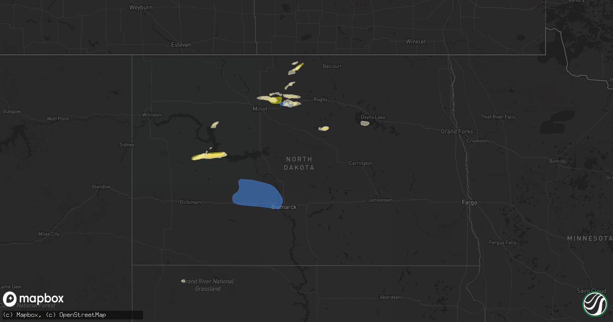
Hail Map in North Dakota on August 24, 2023
Get this storm
August 24 map
$229
one time, instant access
Download today. No call, no setup
Keep the $229
Bought the map and want the full workflow? Apply the entire $229 to a subscription within 7 days. None of it is wasted.
Every map, not just this one
This buys you this map. Subscription and you get every map we run, in the markets you choose from a few cities to whole states to nationwide. Plus real-time alerts the moment a storm fires.
Contact data
Name, contact info, occupancy, even credit band for addresses in the footprint. You go from where it hit to who to call.
Become the source they trust
Unlimited branding weather history reports on demand. You already have the documented answer ready for the property owner, and you are the one who showed up with it.
Property data and RoofTrace estimates
Pull up any address you have got, its value and the exact code rules for that jurisdiction, straight from One Click Code. Then RoofTrace estimates the squares, pitch, and roof value, priced the way you price.
Storm reports in North Dakota
North Dakota
| Date | Description |
|---|---|
| 08/24/20236:30 PM CDT | Torrential rain. Golf course southeast of center. |
| 08/24/20236:30 PM CDT | A local report indicates 70 MPH wind near New Salem |
| 08/24/20236:15 PM CDT | Mesonet station dw6873 hannover. |
| 08/24/20236:15 PM CDT | 2 inch broken tree branches. Torrential rain. |
| 08/24/20236:08 PM CDT | Estimated 60 mph near the morton mercer county line. Winds ongoing at time of warning issuance. |
| 08/24/20234:30 PM CDT | Winds lasted about 15 minutes. |
| 08/24/20233:48 PM CDT | A local report indicates 1.00 inch wind near 1 N Bottineau |
| 08/24/20232:54 PM CDT | Short lived landspout tornado. |
| 08/24/20232:38 PM CDT | Short lived landspout tornado. |
| 08/24/20232:34 PM CDT | Truck window broken out and snowmobile trailer blown down coulee. |
| 08/23/20237:22 PM CDT | Broadcast media relayed report and pictures of gas station canopy on a vehicle downed by thunderstorm wind gusts. Time estimated from radar. |
| 08/23/20237:01 PM CDT | Section of fence destroyed with broken branches at least 1 inch in diamter. Estimated wind speeds in excess of 70 mph. |
All States Impacted by Hail Map on August 24, 2023
Cities Impacted by Hail Map on August 24, 2023
- Williamstown, KY
- Dry Ridge, KY
- Lancaster, KY
- Stanford, KY
- Bottineau, ND
- Norwich, ND
- Surrey, ND
- Deering, ND
- Granville, ND
- Bantry, ND
- Killdeer, ND
- Halliday, ND
- Dunn Center, ND
- Garrison, ND
- Beulah, ND
- Towner, ND
- Piedmont, SD
- Black Hawk, SD
- Franklin, WI
- Oak Creek, WI
- Rapid City, SD
- Caledonia, WI
- Franksville, WI
- Racine, WI
- Lake Mills, WI
- Jefferson, WI
- Plaucheville, LA
- Simmesport, LA
- Murrayville, GA
- Chickamauga, GA
- Flintstone, GA
- Saint Francisville, LA
- Centreville, MS
- Trenton, GA
- Vinton, LA
- Sulphur, LA
- Mountain Rest, SC
- Clarkesville, GA
- Mount Airy, GA
- Sturgis, SD
- Reeves, LA
- Glenburn, ND
- Nemo, SD
- Cornelia, GA
- Rising Fawn, GA
- Flat Rock, AL
- Westminster, SC
- Walhalla, SC
- New Town, ND
- Parshall, ND
- Merriman, NE
- Muskego, WI
- Minot, ND
- Natchez, MS
- Woodville, MS
- Baldwin, GA
- Homer, GA
- Carnesville, GA
- Rocky Mount, VA
- Kramer, ND
- Souris, ND
- Reeseville, WI
- Waterloo, WI
- Columbus, WI
- Sun Prairie, WI
- Deforest, WI
- Ragley, LA
- Longville, LA
- Willow City, ND
- Upham, ND
- Brevard, NC
- Urbana, MO
- Pickens, SC
- Hattieville, AR
- Solgohachia, AR
- Cleveland, AR
- Center Ridge, AR
- Batchelor, LA
- Lettsworth, LA
- Melville, LA
- Berthold, ND
- Milwaukee, WI
- New Berlin, WI
- Cleveland, GA
- Clermont, GA
- Lula, GA
- Hazen, ND
- New Salem, ND
- Glen Ullin, ND
- Stanton, ND
- Center, ND
- Fort Atkinson, WI
- Whitewater, WI
- Mandan, ND
- Gordon, NE
- Bismarck, ND
- Baldwin, ND
- Coopersville, MI
- Marne, MI
- Grand Rapids, MI
- Comstock Park, MI
- Belmont, MI
- Ada, MI
- Rockford, MI
- Belding, MI
- Lowell, MI
- Greenville, MI
- Clarksville, MI
- Saranac, MI
- Lake Odessa, MI
- Ionia, MI
- Cody, NE
- Birch Run, MI
- Clio, MI
- Montrose, MI
- Burt, MI
- Mount Morris, MI
- Flushing, MI
- Flint, MI
- Burton, MI
- Portland, MI
- Sunfield, MI
- Lyons, MI
- Mulliken, MI
- Vermontville, MI
- Charlotte, MI
- Lansing, MI
- Grand Ledge, MI
- Eagle, MI
- Potterville, MI
- Dimondale, MI
- Dewitt, MI
- Westphalia, MI
- Bath, MI
- Muir, MI
- Pewamo, MI
- Saint Johns, MI
- Fowler, MI
- Eaton Rapids, MI
- Holt, MI
- Fowlerville, MI
- Okemos, MI
- Haslett, MI
- Mason, MI
- Webberville, MI
- Williamston, MI
- Dansville, MI
- East Lansing, MI
- Grand Blanc, MI
- Elsie, MI
- Owosso, MI
- Henderson, MI
- Ovid, MI
- Laingsburg, MI
- Morrice, MI
- Perry, MI
- Bancroft, MI
- Vernon, MI
- Lennon, MI
- Corunna, MI
- Durand, MI
- Byron, MI
- Howell, MI
- Linden, MI
- Swartz Creek, MI
- Gaines, MI
- Springport, MI
- Onondaga, MI
- Leslie, MI
- Jackson, MI
- Albion, MI
- Rives Junction, MI
- Parma, MI
- Gregory, MI
- Pleasant Lake, MI
- Munith, MI
- Stockbridge, MI
- Fenton, MI
- Pinckney, MI
- Hartland, MI
- Davisburg, MI
- Holly, MI
- Grass Lake, MI
- Brighton, MI
- Dexter, MI
- Chelsea, MI
- Highland, MI
- South Lyon, MI
- Milford, MI
- Michigan Center, MI
- Hamburg, MI
- Ann Arbor, MI
- Whitmore Lake, MI
- Clarkston, MI
- New Hudson, MI
- Ortonville, MI
- White Lake, MI
- Walled Lake, MI
- Wixom, MI
- Plymouth, MI
- Northville, MI
- Commerce Township, MI
- Novi, MI
- Waterford, MI
- West Bloomfield, MI
- Farmington, MI
- Keego Harbor, MI
- Bloomfield Hills, MI
- Pontiac, MI
- Auburn Hills, MI
- Berkley, MI
- Birmingham, MI
- Livonia, MI
- Redford, MI
- Oak Park, MI
- Franklin, MI
- Southfield, MI
- Canton, MI
- Detroit, MI
- Westland, MI
- Ferndale, MI
- Dearborn Heights, MI
- Highland Park, MI
- Inkster, MI
- Hamtramck, MI
- Dearborn, MI
- Garden City, MI
- Taylor, MI
- Belleville, MI
- Allen Park, MI
- Wayne, MI
- Romulus, MI
- Melvindale, MI
- Brooklyn, MI
- Manchester, MI
- Norvell, MI
- Clinton, MI
- Napoleon, MI
- Saline, MI
- Tecumseh, MI
- Maybee, MI
- Carleton, MI
- Britton, MI
- Newport, MI
- Milan, MI
- Willis, MI
- Ypsilanti, MI
- River Rouge, MI
- Trenton, MI
- Riverview, MI
- Wyandotte, MI
- Tipton, MI
- Flat Rock, MI
- Southgate, MI
- Lincoln Park, MI
- Ecorse, MI
- New Boston, MI
- Madison Heights, MI
- Hazel Park, MI
- Warren, MI
- Royal Oak, MI
- Pleasant Ridge, MI
- Huntington Woods, MI
- Dundee, MI
- Temperance, MI
- Deerfield, MI
- Petersburg, MI
- South Rockwood, MI
- Grosse Ile, MI
- Rockwood, MI
- Ida, MI
- Monroe, MI
- Ottawa Lake, MI
- Erie, MI
- Luna Pier, MI
- Lambertville, MI
- Riga, MI
- La Salle, MI
- Toledo, OH
- Blissfield, MI
- Rossford, OH
- Sylvania, OH
- Oregon, OH
- Curtice, OH
- Northwood, OH
- Harbor View, OH
- Clay Center, OH
- Walbridge, OH
- Graytown, OH
- Millbury, OH
- Williston, OH
- Lindsey, OH
- Martin, OH
- Fremont, OH
- Elmore, OH
- Genoa, OH
- Rocky Ridge, OH
- Oak Harbor, OH
- Port Clinton, OH
- Lacarne, OH
- Woodville, OH
- Put In Bay, OH
- Middle Bass, OH
- Isle Saint George, OH
- Sandusky, OH
- Kelleys Island, OH
- Vickery, OH
- Castalia, OH
- Clyde, OH
- Lakeside Marblehead, OH
- Bellevue, OH
- Milan, OH
- Norwalk, OH
- Monroeville, OH
- Gibsonburg, OH
- Perrysburg, OH
- Huron, OH
- Lorain, OH
- Vermilion, OH
- Collins, OH
- Berlin Heights, OH
- Amherst, OH
- Sheffield Lake, OH
- Wakeman, OH
- Oberlin, OH
- Avon Lake, OH
- Elyria, OH
- Berea, OH
- Lakewood, OH
- Grand River, OH
- Eastlake, OH
- Painesville, OH
- Independence, OH
- Strongsville, OH
- Beachwood, OH
- Perry, OH
- Columbia Station, OH
- North Olmsted, OH
- Westlake, OH
- Chesterland, OH
- Gates Mills, OH
- Euclid, OH
- North Ridgeville, OH
- Willoughby, OH
- Mentor, OH
- Bay Village, OH
- Avon, OH
- Brookpark, OH
- Cleveland, OH
- Wickliffe, OH
- Olmsted Falls, OH
- Rocky River, OH
- Grafton, OH
- North Royalton, OH
- Brunswick, OH
- Chardon, OH
- Broadview Heights, OH
- Akron, MI
- Grant, MI
- Twin Lake, MI
- Linwood, MI
- Pinconning, MI
- Atkins, AR
- Bailey, MI
- Fremont, MI
- Allen, SD
- Eunice, LA
- Basile, LA
- Iota, LA
- Harvey, ND
- North Branch, MI
- Imlay City, MI
- Brown City, MI
- Newaygo, MI
- Delavan, WI
- Yale, MI
- Whitman, NE
- Valentine, NE
- Walworth, WI
- Shepherd, MI
- Salisbury, NC
- Raymond, MS
- Terry, MS
- White Cloud, MI
- Deckerville, MI
- Casnovia, MI
- Kent City, MI
- Prairie City, SD
- Reva, SD
- Esmond, ND
- Maddock, ND
- Milton, WI
- Hot Springs National Park, AR
- Interior, SD
- Wanblee, SD
- Devils Lake, ND
- Saint Michael, ND
- Oberon, ND
- Decatur, MI
- Grayson, GA
- Snellville, GA
- Loganville, GA
- Watertown, WI
- Bridgeport, MI
- Saginaw, MI
- Kountze, TX
- Nunica, MI
- Silsbee, TX
- Lodgepole, SD
- Conklin, MI
- New Haven, MI
- Richmond, MI
- Roxie, MS
- Big Bend, WI
- Martin, SD
- Harrison, MI
- Utica, MS
- Port Gibson, MS
- Newell, SD
- Fontana, WI
- Darien, WI
- Beaverton, MI
- Lake, MI
- Clare, MI
- Gladwin, MI
- Farwell, MI
- Menomonee Falls, WI
- Emmett, MI
- Capac, MI
- Memphis, MI
- Allenton, MI
- Sparta, MI
- Ravenna, MI
- Clifford, MI
- Silverwood, MI
- Mayville, MI
- Midland, MI
- Batesland, SD
- Dequincy, LA
- Mukwonago, WI
- Saint Louis, MI
- Breckenridge, MI
- Alma, MI
- Ithaca, MI
- Muskegon, MI
- Allendale, MI
- Woodland, MI
- Alto, MI
- Freeland, MI
- Hope, MI
- Auburn, MI
- Marshall, WI
- Silva, MO
- Sturtevant, WI
- Kenosha, WI
- Avalon, WI
- Sanford, MI
- Coleman, MI
- Lilburn, GA
- Stone Mountain, GA
- Brecksville, OH
- Solon, OH
- Northfield, OH
- Richfield, OH
- Bedford, OH
- Maple Heights, OH
- Chagrin Falls, OH
- Medina, OH
- Hinckley, OH
- Valley City, OH
- Hudson, OH
- Macedonia, OH
- Peninsula, OH
- Novelty, OH
- Twinsburg, OH
- Akron, OH
- Newbury, OH
- Huntsburg, OH
- Thompson, OH
- Windsor, OH
- North Bloomfield, OH
- Orwell, OH
- Middlefield, OH
- Montville, OH
- Mantua, OH
- Burton, OH
- Aurora, OH
- Hiram, OH
- Madison, OH
- Cuyahoga Falls, OH
- Munroe Falls, OH
- Barberton, OH
- Streetsboro, OH
- Garrettsville, OH
- Kent, OH
- Ravenna, OH
- Stow, OH
- Atwater, OH
- Mogadore, OH
- Hartville, OH
- West Farmington, OH
- Southington, OH
- Louisville, OH
- Canton, OH
- Tallmadge, OH
- Bristolville, OH
- Deerfield, OH
- Windham, OH
- Uniontown, OH
- Limaville, OH
- Alliance, OH
- Diamond, OH
- Newton Falls, OH
- Rootstown, OH
- Lakemore, OH
- Sebring, OH
- Paris, OH
- Leavittsburg, OH
- Damascus, OH
- Warren, OH
- Berlin Center, OH
- Homeworth, OH
- North Jackson, OH
- Canfield, OH
- Lake Milton, OH
- Salem, OH
- North Benton, OH
- Beloit, OH
- Rugby, ND
- Morenci, MI
- Sand Creek, MI
- Clayton, MI
- East Rochester, OH
- Kensington, OH
- Rochester, MI
- Pittsburgh, PA
- Glenshaw, PA
- Allison Park, PA
- Elizabeth, PA
- Bunola, PA
- Monongahela, PA
- Elrama, PA
- Clairton, PA
- Finleyville, PA
- Lowber, PA
- Belle Vernon, PA
- Buena Vista, PA
- West Newton, PA
- Sutersville, PA
- Herminie, PA
- Irwin, PA
- Philippi, WV
- Moatsville, WV
- Montrose, WV
- Tidioute, PA
- Mount Pleasant, PA
- Acme, PA
- Flemington, WV
- Cheswick, PA
- Oxford, MI
- Paden City, WV
- Brookville, PA
- Sistersville, WV
- Middlebourne, WV
- Zanesville, OH
- Norwich, OH
- Adamsville, OH
- New Concord, OH
- Ruffs Dale, PA
- Sardis, OH
- Clarington, OH
- Mount Clare, WV
- Caldwell, OH
- Dexter City, OH
- Lower Salem, OH
- Greendale, WI
- Alliance, NE
- Mount Blanchard, OH
- Carey, OH
- Wharton, OH
- Lost Creek, WV
- Buckhannon, WV
- Lake Orion, MI
- Marienville, PA
- Erie, PA
- Waterford, PA
- Donegal, PA
- Stahlstown, PA
- Scottdale, PA
- White, PA
- Cecil, PA
- McDonald, PA
- Canonsburg, PA
- Summerfield, OH
- Bridgeport, WV
- Clarksburg, WV
- New Baltimore, MI
- Casco, MI
- Minerva, OH
- Muse, PA
- Houston, PA
- Smithfield, PA
- Clothier, WV
- Hamlin, WV
- Kenna, WV
- Liberty, WV
- Charleston, WV
- Given, WV
- Poca, WV
- Charleroi, PA
- Belmont, WV
- Saint Marys, WV
- Newport, OH
- New Martinsville, WV
- Normalville, PA
- Connellsville, PA
- Everson, PA
- Gallipolis, OH
- Point Pleasant, WV
- Hernshaw, WV
- Winifrede, WV
- Belle, WV
- Cabin Creek, WV
- Le Roy, WV
- Syracuse, OH
- New Haven, WV
- Mason, WV
- Letart, WV
- Hartford, WV
- West Columbia, WV
- Racine, OH
- Woodsfield, OH
- Sycamore, OH
- Nevada, OH
- Chloe, WV
- Newton, WV
- Looneyville, WV
- Masontown, PA
- Martin, PA
- Greensboro, PA
- Leon, WV
- Reader, WV
- Hannibal, OH
- Gallipolis Ferry, WV
- Buffalo, WV
- Apple Grove, WV
- Southside, WV
- Henderson, WV
- Marion, OH
- Dixie, WV
- Lizemores, WV
- Washington, WV
- Gandeeville, WV
- Elkview, WV
- Walton, WV
- Advent, WV
- Greensburg, PA
- Yukon, PA
- New Stanton, PA
- Madison, PA
- Hunker, PA
- Youngwood, PA
- Darragh, PA
- Arnoldsburg, WV
- Orma, WV
- Walkersville, WV
- Ivydale, WV
- Maysel, WV
- Amma, WV
- Wallback, WV
- Clay, WV
- Left Hand, WV
- Clendenin, WV
- Procious, WV
- Reno, OH
- Marietta, OH
- Marengo, OH
- Fredericktown, OH
- Cardington, OH
- Mount Vernon, OH
- Coolville, OH
- Smithton, PA
- Champion, PA
- Alverton, PA
- Jones Mills, PA
- Dickerson Run, PA
- Indian Head, PA
- Melcroft, PA
- Perryopolis, PA
- Dawson, PA
- Vanderbilt, PA
- Dunbar, PA
- Tarrs, PA
- Somerset, PA
- Lemont Furnace, PA
- Wyano, PA
- Smock, PA
- Uniontown, PA
- Mount Braddock, PA
- Hopwood, PA
- Wickhaven, PA
- Star Junction, PA
- Mill Run, PA
- Griffithsville, WV
- Hurricane, WV
- Ripley, WV
- Pond Gap, WV
- Pomeroy, OH
- Lewisville, OH
- Vincent, OH
- Belpre, OH
- Rockport, WV
- Ravenswood, WV
- Sandyville, WV
- Elizabeth, WV
- Cardale, PA
- New Salem, PA
- Brownsville, PA
- Merrittstown, PA
- Allison, PA
- Republic, PA
- Grindstone, PA
- Cottageville, WV
- Mount Alto, WV
- Millwood, WV
- Monessen, PA
- Spencer, WV
- Saint Albans, WV
- Eleanor, WV
- Milton, WV
- Winfield, WV
- Red House, WV
- Sod, WV
- West Hamlin, WV
- Fraziers Bottom, WV
- Culloden, WV
- Myra, WV
- Scott Depot, WV
- Branchland, WV
- Elco, PA
- Newell, PA
- Fayette City, PA
- Roscoe, PA
- Carmichaels, PA
- Albany, OH
- Upper Sandusky, OH
- Millstone, WV
- Confluence, PA
- Markleysburg, PA
- Albright, WV
- Bruceton Mills, WV
- Belleville, WV
- Mineral Wells, WV
- Williamstown, WV
- Whipple, OH
- Ranger, WV
- Duck, WV
- Morral, OH
- Reedy, WV
- Gay, WV
- Reedsville, OH
- Long Bottom, OH
- Belington, WV
- Utica, OH
- Morgantown, WV
- Lowell, OH
- Evans, WV
- Newark, OH
- Saint Louisville, OH
- Independence, IA
- Jesup, IA
- New Matamoras, OH
- Seth, WV
- Eskdale, WV
- Blount, WV
- Comfort, WV
- Tornado, WV
- Lagrange, OH
- Spencer, OH


