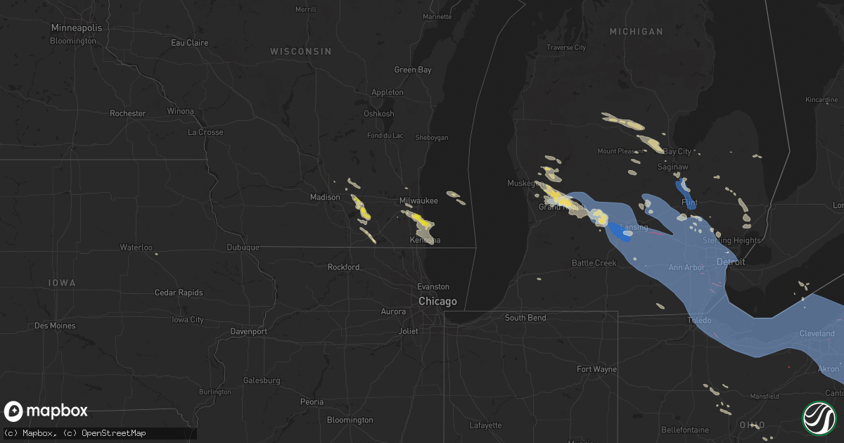
Hail Map on August 24, 2023
Get this storm
August 24 map
$229
one time, instant access
Download today. No call, no setup
Keep the $229
Bought the map and want the full workflow? Apply the entire $229 to a subscription within 7 days. None of it is wasted.
Every map, not just this one
This buys you this map. Subscription and you get every map we run, in the markets you choose from a few cities to whole states to nationwide. Plus real-time alerts the moment a storm fires.
Contact data
Name, contact info, occupancy, even credit band for addresses in the footprint. You go from where it hit to who to call.
Become the source they trust
Unlimited branding weather history reports on demand. You already have the documented answer ready for the property owner, and you are the one who showed up with it.
Property data and RoofTrace estimates
Pull up any address you have got, its value and the exact code rules for that jurisdiction, straight from One Click Code. Then RoofTrace estimates the squares, pitch, and roof value, priced the way you price.
States Impacted by Hail Map on August 24, 2023
Storm reports
Maryland
| Date | Description |
|---|---|
| 08/24/20232:14 AM CDT | 4 to 5 trees and powerlines down near the intersection of hare hollow road and new germany road |
North Dakota
| Date | Description |
|---|---|
| 08/24/20236:30 PM CDT | A local report indicates 70 MPH wind near New Salem |
| 08/24/20236:30 PM CDT | Torrential rain. Golf course southeast of center. |
| 08/24/20236:15 PM CDT | 2 inch broken tree branches. Torrential rain. |
| 08/24/20236:15 PM CDT | Mesonet station dw6873 hannover. |
| 08/24/20236:08 PM CDT | Estimated 60 mph near the morton mercer county line. Winds ongoing at time of warning issuance. |
| 08/24/20234:30 PM CDT | Winds lasted about 15 minutes. |
| 08/24/20233:48 PM CDT | A local report indicates 1.00 inch wind near 1 N Bottineau |
| 08/24/20232:54 PM CDT | Short lived landspout tornado. |
| 08/24/20232:38 PM CDT | Short lived landspout tornado. |
| 08/24/20232:34 PM CDT | Truck window broken out and snowmobile trailer blown down coulee. |
| 08/23/20237:22 PM CDT | Broadcast media relayed report and pictures of gas station canopy on a vehicle downed by thunderstorm wind gusts. Time estimated from radar. |
| 08/23/20237:01 PM CDT | Section of fence destroyed with broken branches at least 1 inch in diamter. Estimated wind speeds in excess of 70 mph. |
West Virginia
| Date | Description |
|---|---|
| 08/24/20236:25 AM CDT | County 911 center reports tree down on big branch road. |
| 08/24/20236:15 AM CDT | Kanwaha county 911 center has reports of 2 trees down at maccorkle avenue and chesapeake avenue in south charleston. Time estimated by radar. |
| 08/24/20236:15 AM CDT | Kanwaha county 911 center has reports of 2 trees down at macco |
| 08/24/20235:57 AM CDT | Have reports of a tree down in the 1300 block of roosevelt blvd in eleanor. Report came from putnam county 911 center. Time estimated from radar. |
| 08/24/20235:55 AM CDT | Putnam county 911 center reports a tree down at the intersection of winfield rd and hurricane creek rd between the mulch plant and the golf course. It is blocking the n |
| 08/24/20235:40 AM CDT | Kanawha county 911 center advised they received a report of a tree down at the intersection of maccorkle ave and paint creek rd. Time estimated via radar. |
| 08/24/20235:30 AM CDT | Kanawha county 911 has reports of a tree down in the 2200 block of third avenue in charleston. Time estimated via radar. |
| 08/24/20235:15 AM CDT | County 911 center reports a tree down on manilla ridge road between route 62 and homebrew hollow road. |
| 08/24/20235:15 AM CDT | County 911 center reports a tree down on manilla ridge road between route 62 and |
| 08/24/20235:15 AM CDT | Kanawha county 911 center received a report of a tree down along leatherwood road in clendenin around the 400 block. Time estimated by radar. |
| 08/24/20235:13 AM CDT | Tree down across cemetery rd... Time estimated from radar. |
| 08/24/20233:00 AM CDT | Tree down across the roadway on trap springs rd. |
| 08/24/20232:55 AM CDT | Doddridge county/ritchie county joint 911 center received reports of a tree down on bunnell run rd in harrisville... Ritchie county. Time estimated via radar. |
| 08/24/20232:55 AM CDT | Tree down across duckworth rd. |
| 08/24/20232:01 AM CDT | Report of some trees down. Time estimated based on radar. |
| 08/24/20232:00 AM CDT | A local report indicates 67 MPH wind near 1 NW Morgantown |
| 08/24/20231:55 AM CDT | Report of a few trees and power lines down in the cheat lake area. Time estimated based on radar. |
South Carolina
| Date | Description |
|---|---|
| 08/24/20233:28 PM CDT | Report from mping: trees uprooted or snapped; one fell on a house. |
| 08/24/20233:00 PM CDT | Trees down in the area. Time estimated by radar. |
| 08/24/20232:40 PM CDT | Multiple trees down. Time and location estimated by radar. |
| 08/24/20232:35 PM CDT | Trees down in the area. Time estimated by radar. |
| 08/24/20232:25 PM CDT | Multiple trees down. Location and time estimated by radar. |
Ohio
| Date | Description |
|---|---|
| 08/24/20232:08 PM CDT | Numerous trees down near state rd and sprague rd. |
| 08/24/20232:01 PM CDT | North royalton fd reported several tree blown down and power lines blown down between w sprague road and bunker road just east of state road 94. |
| 08/24/20231:42 AM CDT | Tree down on road. |
| 08/24/202312:00 AM CDT | Large tree snapped at base along brenda ln |
| 08/23/202311:59 PM CDT | Numerous trees and power lines down. One tree on a house. |
| 08/23/202311:57 PM CDT | Numerous trees down over several hundred yards of wooded area. Cornfield levelled by wind. |
| 08/23/202311:55 PM CDT | Several trees blown down on s broad street and fair street in canfield. Also a power line is down on fairground boulevard. |
| 08/23/202311:50 PM CDT | Tree on house. |
| 08/23/202311:48 PM CDT | Tree down... Partially on a house. |
| 08/23/202311:40 PM CDT | Report from spotter network...multiple large trees and power lines down in hartville... Especially along n prospect ave. Time estimated via radar. |
| 08/23/202311:39 PM CDT | Tree reported downed on a house in wooster. Time estimated via radar. |
| 08/23/202311:35 PM CDT | An ef-0 tornado has been confirmed in bristolville beginning just east of mahan denman road on hyde shaffer road where large tree branches were snapped. The tornado tra |
| 08/23/202311:32 PM CDT | Damage to a property... Including the collapse of a car port and damage to a roof. |
| 08/23/202311:31 PM CDT | Multiple tress and limbs down in tuscora park. |
| 08/23/202311:28 PM CDT | Spotter 1.5 miles sw of kent reported numerous trees and limbs snapped... Power out... And a measured 80 mph gust on a backyard weather station. |
| 08/23/202311:27 PM CDT | Tree down on a car in goodyear heights in akron. Report via social media. |
| 08/23/202311:27 PM CDT | Six large trees down near state route 43 and i-76. Additional limbs and branches were also reported down. |
| 08/23/202311:26 PM CDT | Tree down in front of homestead manor trailer park. |
| 08/23/202311:22 PM CDT | Tree downed across state route 91 at stow road in stow. Time estimated via radar. |
| 08/23/202311:21 PM CDT | Report from mping: 3-inch tree limbs broken; power poles broken. Time adjusted via radar. |
| 08/23/202311:20 PM CDT | Tree down on house with structural damage - mutual aid to munson along meadowhurst road. Large amount of debris on auburn rd. |
| 08/23/202311:17 PM CDT | Report from mping: 3-inch tree limbs broken; power poles broken. Time adjusted via radar. |
| 08/23/202311:15 PM CDT | Tree fell on house-did make roof collapse and rain is pouring inside. Trees down on wilson mills & burlington ridge |
| 08/23/202311:13 PM CDT | Multiple trees down or snapped off. |
| 08/23/202311:12 PM CDT | Buoy station faio1 fairport... Oh. |
| 08/23/202311:12 PM CDT | Report from mping: trees uprooted or snapped. Time adjusted via radar. |
| 08/23/202311:07 PM CDT | Report from mping: 3-inch tree limbs broken; power poles broken. Time adjusted via radar. |
| 08/23/202311:07 PM CDT | Significant tree damage on vallevista dr in mayfield heights. Numerous large trees are down. |
| 08/23/202311:05 PM CDT | One of the coverings on the greenhouses at ohio city farm blew off. |
| 08/23/202311:05 PM CDT | Multiple trees down on som centre road in willoughby. Video from social media. |
| 08/23/202311:04 PM CDT | An ef1 tornado has been confirmed in mentor. The tornado began just west of dartmoor road near mentor avenue where large trees were downed. The tornado tracked east... |
| 08/23/202311:03 PM CDT | Report from mping: trees uprooted or snapped. Time adjusted via radar. |
| 08/23/202311:02 PM CDT | Numerous trees down and snapped. |
| 08/23/202311:01 PM CDT | Trees down on euclid avenue near i-90 interchange. |
| 08/23/202311:00 PM CDT | Numerous trees down... Some on houses across the area. |
| 08/23/202311:00 PM CDT | Report of numerous trees and wires down on edgecliff dr near e 255th st. |
| 08/23/202310:59 PM CDT | Asos station kbkl cleveland reported a 65 kt wind gust. |
| 08/23/202310:59 PM CDT | An ef1 tornado has been confirmed beginning near east 71st street and chester avenue... Ending near east 89th street and euclid avenue. Extensive tree damage occurred a |
| 08/23/202310:58 PM CDT | Large tree fell on the dunham tavern museum causing roof damage. |
| 08/23/202310:58 PM CDT | Roof and steeple damage at the new life at calvary church. |
| 08/23/202310:52 PM CDT | Report of wires down on clague road south of center ridge. A tree is also down onto an occupied vehicle. Report relayed via social media. |
| 08/23/202310:30 PM CDT | Large tree blown down on to a house. |
| 08/23/202310:30 PM CDT | Report from mping: 3-inch tree limbs broken; power poles broken. Time adjusted via radar. |
| 08/23/202310:25 PM CDT | Several large trees blown down blocking roads on put-in-bay. |
| 08/23/202310:12 PM CDT | Reports of windows blown out of houses near rocky ridge. Possible tornado. |
| 08/23/202310:09 PM CDT | Several trees snapped and a business sign damaged north of elmore. Time estimated via radar. |
| 08/23/202310:08 PM CDT | An ef1 tornado has been confirmed beginning near south nissen road and west deno road where several tree limbs were broken off. The tornado continued southeast and dama |
| 08/23/202310:00 PM CDT | Large tree limbs blown north of the toledo zoo. |
| 08/23/20239:58 PM CDT | Power lines blown down on orchard road. |
| 08/23/20239:54 PM CDT | Buoy station thro1 toledo... Oh. |
Georgia
| Date | Description |
|---|---|
| 08/24/20235:40 PM CDT | Large tree down on a home. |
| 08/24/20235:30 PM CDT | Tree down across roadway. |
| 08/24/20235:20 PM CDT | Tree downed by strong winds. |
| 08/24/20234:20 PM CDT | Tree down on power line. Time estimated by radar. |
| 08/24/20234:15 PM CDT | Multiple trees down. Time and location estimated by radar. |
| 08/24/20232:25 PM CDT | Multiple trees down. Time and location estimated by radar. |
Nebraska
| Date | Description |
|---|---|
| 08/24/20236:31 PM CDT | Motorist reported a cracked windshield also. |
| 08/24/20236:15 PM CDT | A local report indicates 1.00 inch wind near 15 SW Merriman |
South Dakota
| Date | Description |
|---|---|
| 08/24/20235:50 PM CDT | Powerlines down at the corner of sturgis and peaceful pines road. |
| 08/24/20235:02 PM CDT | Mping report |
| 08/24/20234:49 PM CDT | A local report indicates 1.00 inch wind near 1 NNW Piedmont |
Wisconsin
| Date | Description |
|---|---|
| 08/24/20236:44 PM CDT | Approximately 1-ft diameter branch fell on sidewalk. Diameter estimated from photo. Time estimated from radar. |
| 08/24/20236:32 PM CDT | Report from mping: quarter (1.00 i |
| 08/24/20236:32 PM CDT | Report from mping: quarter |
| 08/24/20236:30 PM CDT | Multiple trees down across town. Time est from radar. |
| 08/24/20236:28 PM CDT | Approximately 2ft diameter tre |
| 08/24/20236:28 PM CDT | Approximately 2ft diameter tree |
| 08/24/20236:25 PM CDT | Report from mping: quarter |
| 08/24/20236:15 PM CDT | Multiple trees down across town. Time est from radar. |
| 08/24/20235:25 PM CDT | Size est by picture. Time est by radar. |
| 08/24/20235:15 PM CDT | Twitter report of half dollar sized hail with attached photo. |
| 08/24/20235:13 PM CDT | Report from mping: quarter |
| 08/23/20237:58 PM CDT | Delayed report of tree damage. |
| 08/23/20237:45 PM CDT | Delayed report. Multiple reports of tree damage northwest of delavan. Also a report of a damage shed. |
Pennsylvania
| Date | Description |
|---|---|
| 08/24/20234:34 AM CDT | Reports of many trees down along ridge road and mccorkle road. |
| 08/24/20232:03 AM CDT | Trees down on rt 160 near distillery rd and glencoe rd. Time est via radar. |
| 08/24/20231:59 AM CDT | Tree damage and partial roof torn off a barn. |
| 08/24/20231:55 AM CDT | Trees down on water level rd near coal yard rd. Time est via radar. |
| 08/24/20231:51 AM CDT | Small limbs down |
| 08/24/20231:51 AM CDT | Trees and wires down on broadway street in rockwood borough. |
| 08/24/20231:49 AM CDT | Report of multiple trees down in the 3000 block of copper kettle highway in milford township. |
| 08/24/20231:48 AM CDT | Multiple trees down on turkey foot trail road near porter road in upper turkeyfoot township. |
| 08/24/20231:47 AM CDT | Trees down blocking jefferson rd. Time est via radar. |
| 08/24/20231:45 AM CDT | Utility lines down along route 403 north. |
| 08/24/20231:44 AM CDT | Tree down across route 30 between jennerstown and the westmoreland county line. Time est via radar. |
| 08/24/20231:43 AM CDT | Multiple trees and electrical lines down on county line road in middlecreek twp. |
| 08/24/20231:38 AM CDT | Trees uprooted or snapped |
| 08/24/20231:37 AM CDT | Tree down along route 711. |
| 08/24/20231:36 AM CDT | Trailer blown off its foundation along springfeild pike. |
| 08/24/20231:35 AM CDT | Tree down on west crawford ave. Time based on radar. |
| 08/24/20231:33 AM CDT | Mping report of 1 inch broken tree limbs along ridge blvd. |
| 08/24/20231:29 AM CDT | Trees snapped and limbs down |
| 08/24/20231:27 AM CDT | Tree down along morris street. |
| 08/24/20231:21 AM CDT | Tree down along route 286 east. |
| 08/24/20231:21 AM CDT | Large limbs down |
| 08/24/20231:19 AM CDT | Number of trees down near centerville |
| 08/24/20231:18 AM CDT | Tree down. |
| 08/24/20231:17 AM CDT | A number of trees down in the city of charleroi. |
| 08/24/20231:17 AM CDT | Number of trees down in california... Pa. |
| 08/24/20231:17 AM CDT | Tree down on st. Mary's road. Time based on radar. |
| 08/24/20231:15 AM CDT | Large tree limbs/branches down |
| 08/24/20231:13 AM CDT | Tree down on house |
| 08/24/20231:11 AM CDT | Tree down on guard rail along lone pine rd |
| 08/24/20231:10 AM CDT | Trees down in fayette city. |
| 08/24/20231:10 AM CDT | Four trees down on hurst road. Time based on radar. |
| 08/24/20231:09 AM CDT | Wall road had trees and wires down. |
| 08/24/20231:09 AM CDT | Tree down on harvey ave and kunkle street. |
| 08/24/20231:05 AM CDT | Multiple trees and wires down near coal valley road and clariton road. |
| 08/24/20231:05 AM CDT | Number of trees down in union township. |
| 08/24/20231:04 AM CDT | Trees down in nottingham township. |
| 08/24/202312:59 AM CDT | Trees uprooted or snapped |
| 08/24/202312:56 AM CDT | Small limbs down |
| 08/24/202312:54 AM CDT | Reports of many trees down along ridge road and mccorkle road. |
| 08/24/202312:54 AM CDT | A few trees down. |
| 08/24/202312:48 AM CDT | Roof damage to several buildings including a construction business along fidelity drive and vicinity. Numerous trees down which also caused damage as they fell. |
| 08/24/202312:44 AM CDT | Number of trees down in smith township. |
| 08/24/202312:40 AM CDT | Numerous trees uprooted and trunks snapped. Extensive debris reported |
| 08/24/202312:40 AM CDT | Tree on a home on shamrock drive. No injures reported. |
| 08/24/202312:38 AM CDT | Trees down near quaker village shopping center along ohio river blvd. |
| 08/24/202312:37 AM CDT | Garage door bent from high wind along sterling ridge and battle ridge road. |
| 08/24/202312:35 AM CDT | Tree down near bellview dr and woodland rd. Relayed by nws wfo vef |
| 08/24/202312:35 AM CDT | Multiple trees down causing damage to cars and homes on whitby place |
| 08/24/202312:32 AM CDT | Small limbs down |
| 08/24/202312:32 AM CDT | Large tree branches down and metal siding blown off of building |
| 08/24/202312:31 AM CDT | Route 30 from sr 151 to sr 18 will be closed for an extended period of time due to multiple trees and wires down. Time estimated by radar. |
| 08/24/202312:13 AM CDT | Large tree down on springfield church road. |
| 08/24/202312:08 AM CDT | Tree down on south northview avenue. |
| 08/24/202312:06 AM CDT | Multiple trees down |
| 08/24/202312:06 AM CDT | Multiple trees down |
| 08/24/202312:06 AM CDT | Tree down on n. Hope mill road. |
| 08/24/202312:03 AM CDT | Small limbs down |
| 08/23/202311:57 PM CDT | A number of trees down. |
| 08/23/202311:56 PM CDT | Trees down in sharon. |
| 08/23/202311:56 PM CDT | Small limbs down |
| 08/23/202311:54 PM CDT | Wires down on road. |
| 08/23/202311:46 PM CDT | Multiple trees down across the area. |
| 08/23/202311:10 PM CDT | Tree down on route 957. |
| 08/23/202310:55 PM CDT | Tree down on road. |
| 08/23/202310:48 PM CDT | Tree down with wires. |
| 08/23/202310:38 PM CDT | Tree down on road. |
Texas
| Date | Description |
|---|---|
| 08/24/20235:57 PM CDT | Trees down at san jacinto college-north campus. |
| 08/24/20235:49 PM CDT | Trees down and fence damaged. |
Arkansas
| Date | Description |
|---|---|
| 08/24/20234:30 PM CDT | Damage to roof and siding of several outbuildings. Damage on house roof. |
Michigan
| Date | Description |
|---|---|
| 08/23/20239:45 PM CDT | Numerous trees reported down across gibraltar... Mainly focused over the southern part of the city. |
| 08/23/20239:43 PM CDT | Confirmed ef-1 tornado with maximum winds of 90 mph and a path of 1.4 miles. |
| 08/23/20239:42 PM CDT | Photos of large trees down sent in. |
| 08/23/20239:42 PM CDT | Received multiple reports of damage to a mobile home park in frenchtown township. Social media photos show mobile home knocked off foundation. |
| 08/23/20239:39 PM CDT | Confirmed ef-1 tornado in south rockwood with maximum winds of 105 mph and a path length of 5.4 miles. |
| 08/23/20239:39 PM CDT | Photos of trees down sent in via facebook. |
| 08/23/20239:38 PM CDT | A weak tornado touched down in a farm field in ash township north of newport road and half a mile west of north telegraph road. The tornado tracked southeast and hit fr |
| 08/23/20239:33 PM CDT | Measured at detroit metro airport. |
| 08/23/20239:30 PM CDT | Reported on the west side of detroit... Near the intersection of evergreen and joy. |
| 08/23/20239:24 PM CDT | Social media photos received of large downed limb. Public described tree as being cracked in half. |
| 08/23/20239:23 PM CDT | The weak tornado touched down near the wagner homestead farm with mainly leaf and twigs blown down. The tornado tracked southeast and crossed elwell road near belmont d |
| 08/23/20239:22 PM CDT | Multiple trees uprooted... Shingles off roofs. |
| 08/23/20239:21 PM CDT | Dispatch reports trees and power lines down across the county. Numerous reports came from around clinton township. |
| 08/23/20239:20 PM CDT | 25 foot pine tree was uprooted and landed on neighbor's roof in neighborhood near sheldon rd and palmer rd. |
| 08/23/20239:20 PM CDT | Social media photos of large tree branches down at 7 mile and beech. |
| 08/23/20239:20 PM CDT | Measured via anemometer. Corrected time. |
| 08/23/20239:20 PM CDT | Large tree blown onto road. |
| 08/23/20239:19 PM CDT | The weak tornado touched down just northwest of pheasant run golf course and track southeast. Dozens of thrrees were downed and uprooted. The tornado continued southeas |
| 08/23/20239:15 PM CDT | Trees and power lines reported down across salem |
| 08/23/20239:10 PM CDT | 1 foot diameter tree reported down. |
| 08/23/20239:10 PM CDT | Spotter reported large trees down on cars... Streets impassable around hiscock st and daniel st. |
| 08/23/20239:07 PM CDT | A local report indicates 64 MPH wind near 3 E Sandstone |
| 08/23/20239:07 PM CDT | Spotter reports healthy 8 inch limb down in backyard. Numerous smaller limbs down around neighborhood. |
| 08/23/20239:05 PM CDT | Trees reported down across green oak township. |
| 08/23/20239:00 PM CDT | Trees reported down at pleasant valley and spencer roads |
| 08/23/20238:46 PM CDT | Numerous trees and tree limbs downed from wet microburst. Estimated winds of 65 mph. |
| 08/23/20238:45 PM CDT | Trees reported down in multiple spots in argentine. |
| 08/23/20238:45 PM CDT | Trees and power lines were reported down across the county. |
| 08/23/20238:44 PM CDT | Public reports multiple 6 to 12 inch diameter limbs down south of fowlerville at nicholson road between grand river and van orden via social media. |
| 08/23/20238:41 PM CDT | Near fenton rd and north long lake rd... 6 inch diameter tree branches down in the road. |
| 08/23/20238:41 PM CDT | A confirmed tornado... Causing ef1 damage with winds up to 90 mph entered livingston county near west branch red cedar river... Crossing wallace rd. Tornado tracked clo |
| 08/23/20238:40 PM CDT | Many trees snapped and uprooted due to straight line winds from wallace road to cedar road... Along and north of west van orgen rd. Estimated wind speeds up to 90 mph. |
| 08/23/20238:40 PM CDT | Marengo twp. Fire reports multiple large trees down. Time estimated via radar. |
| 08/23/20238:35 PM CDT | Roof collapse of a building. Possible tornado. |
| 08/23/20238:35 PM CDT | Multiple cars flipped over on i-96. Possible tornado. |
| 08/23/20238:35 PM CDT | A local report indicates 61 MPH wind near 2 SE Mason |
| 08/23/20238:35 PM CDT | Multiple trees and limbs down across leslie. Time estimated via radar. |
| 08/23/20238:29 PM CDT | *** 1 fatal... 3 inj *** ef-2 tornado in ingham county that moved into livingston county. Path in ingham county around 10.70 miles. Total path 12.00 miles. Estimated ma |
| 08/23/20238:28 PM CDT | Several large trees down damaging a chicken coop. Time estimated via radar. |
| 08/23/20238:22 PM CDT | Multiple large trees down in okemos. Time estimated via radar. |
| 08/23/20238:21 PM CDT | A local report indicates 71 MPH wind near 2 N Edgemont Park |
| 08/23/20238:20 PM CDT | Measured via anemometer. |
| 08/23/20238:17 PM CDT | A local report indicates 70 MPH wind near 2 N Charlotte |
| 08/23/20238:15 PM CDT | Multiple trees uprooted onto homes in the windsor estates mobile home park. |
| 08/23/20238:15 PM CDT | Multiple 4 inch diameter healthy branches down. Time estimated via radar. |
| 08/23/20238:15 PM CDT | Multiple large branches down in colonial village neighborhood. Time estimated via radar. |
| 08/23/20238:12 PM CDT | Trees and limbs down across potterville. Time estimated via radar. |
| 08/23/20238:11 PM CDT | Multiple trees and limbs down. |
| 08/23/20238:10 PM CDT | Two to four inch limbs down. |
| 08/23/20238:10 PM CDT | Large tree down across nixon rd. Numerous wires and large branches down. Time estimated via radar. |
| 08/23/20238:10 PM CDT | City of grand ledge reports numerous wires and trees down across the city. Time estimated via radar. |
| 08/23/20238:10 PM CDT | Numerous trees and limbs down in saint johns. Time estimated via radar. |
| 08/23/20237:50 PM CDT | Multiple trees damaged between peake rd. And butler rd. Time estimated via radar. |
| 08/23/20237:45 PM CDT | Over 30 pine trees down at morrison lake golf course. Time estimated via radar. |
| 08/23/20237:35 PM CDT | Multiple large trees down. |
| 08/23/20237:35 PM CDT | Several large trees down. |
| 08/23/20237:34 PM CDT | Multiple trees down on arrowhead gold course. Time estimated via radar. |
| 08/23/20237:34 PM CDT | Tree down across gavin lake road a few hundred feet south of m44. Time estimated from radar. |
| 08/23/20237:34 PM CDT | Numerous trees down across foreman st. Time estimated via radar. |
| 08/23/20237:30 PM CDT | A local report indicates 60 MPH wind near 1 WNW Comstock Park |
| 08/23/20237:21 PM CDT | Tree on house. Possible tornado. Radar showed debris signature in this area. |
| 08/23/20237:20 PM CDT | Roof off of well built home. Camper flipped. Numerous homes with window and siding damage in scotview dr. Neighborhood. Possible tornado. Time estimated via radar. |
| 08/23/20237:18 PM CDT | Trees across m37 at 7 mile. Possible tornado. Possible damage to structures. Time estimated from radar. |
| 08/23/20237:17 PM CDT | Multiple large trees down. Time estimated via radar. |
| 08/23/20237:15 PM CDT | Path length 8.7 miles. Path width 100 yards. Maximum estimated windspeed 110 mph. |
| 08/23/20237:03 PM CDT | Multiple large branches down. Time estimated via radar. |
Florida
| Date | Description |
|---|---|
| 08/24/20233:52 PM CDT | Video from broadcast media of short lived weak tornado |
Virginia
| Date | Description |
|---|---|
| 08/24/20235:30 PM CDT | Tree blown down blocking smith road. |
| 08/24/20235:19 PM CDT | Tree down causing power outage along daniels creek road and river road. |
| 08/24/20235:02 PM CDT | Tree down blocking one side of riverside dr. |
| 08/24/20235:01 PM CDT | Tree down blocking fair oaks drive. |
| 08/24/20234:55 PM CDT | Tree down blocking intersection of oakcrest circle and avenel drive. |
North Carolina
| Date | Description |
|---|---|
| 08/24/20236:35 PM CDT | Social media report of a tree down on a vehicle. |
| 08/24/20236:31 PM CDT | Multiple trees down in the vicinity of becks church road and e old us highway 64 in lexington. Time estimate by radar. |
| 08/24/20236:25 PM CDT | 2 large trees snapped. Parts may be on a house. Trees down throughout the city. |
| 08/24/20236:25 PM CDT | Corrects previous tstm wnd dmg report from salisbury. 2 large trees snapped. Parts are on a house and car. Multiple other trees down throughout the city along with repo |
| 08/24/20236:24 PM CDT | Multiple trees down in the vicinity of tussey road and beaver creek road. Time estimated by radar. |
| 08/24/20236:13 PM CDT | Multiple trees down in the vicinity of yadkin college road and west oaks ln. Time estimated by radar. |
| 08/24/20236:05 PM CDT | Observed at salisbury hs. |
| 08/24/20236:00 PM CDT | Tree down blocking road. |
| 08/24/20235:50 PM CDT | Multiple trees down at the 6700 block of idols rd. |
| 08/24/20235:41 PM CDT | Trees and power lines down at the 7500 block of lasater rd. |
| 08/24/20235:28 PM CDT | Tree down at lakeway dr near sonata dr. |
| 08/24/20231:27 PM CDT | A report of a power line down and a tree down across blue ridge road. |
| 08/23/20238:44 PM CDT | Report from mping: 3-inch tree limbs broken. |
| 08/23/20238:03 PM CDT | Tree down across old charlotte road. |
| 08/23/20237:55 PM CDT | At least 20 trees down between mount pleasant and concord. |
Tennessee
| Date | Description |
|---|---|
| 08/24/20231:00 PM CDT | A few trees down. |
Cities Impacted by Hail Map on August 24, 2023
- Williamstown, KY
- Dry Ridge, KY
- Lancaster, KY
- Stanford, KY
- Bottineau, ND
- Norwich, ND
- Surrey, ND
- Deering, ND
- Granville, ND
- Bantry, ND
- Killdeer, ND
- Halliday, ND
- Dunn Center, ND
- Garrison, ND
- Beulah, ND
- Towner, ND
- Piedmont, SD
- Black Hawk, SD
- Franklin, WI
- Oak Creek, WI
- Rapid City, SD
- Caledonia, WI
- Franksville, WI
- Racine, WI
- Lake Mills, WI
- Jefferson, WI
- Plaucheville, LA
- Simmesport, LA
- Murrayville, GA
- Chickamauga, GA
- Flintstone, GA
- Saint Francisville, LA
- Centreville, MS
- Trenton, GA
- Vinton, LA
- Sulphur, LA
- Mountain Rest, SC
- Clarkesville, GA
- Mount Airy, GA
- Sturgis, SD
- Reeves, LA
- Glenburn, ND
- Nemo, SD
- Cornelia, GA
- Rising Fawn, GA
- Flat Rock, AL
- Westminster, SC
- Walhalla, SC
- New Town, ND
- Parshall, ND
- Merriman, NE
- Muskego, WI
- Minot, ND
- Natchez, MS
- Woodville, MS
- Baldwin, GA
- Homer, GA
- Carnesville, GA
- Rocky Mount, VA
- Kramer, ND
- Souris, ND
- Reeseville, WI
- Waterloo, WI
- Columbus, WI
- Sun Prairie, WI
- Deforest, WI
- Ragley, LA
- Longville, LA
- Willow City, ND
- Upham, ND
- Brevard, NC
- Urbana, MO
- Pickens, SC
- Hattieville, AR
- Solgohachia, AR
- Cleveland, AR
- Center Ridge, AR
- Batchelor, LA
- Lettsworth, LA
- Melville, LA
- Berthold, ND
- Milwaukee, WI
- New Berlin, WI
- Cleveland, GA
- Clermont, GA
- Lula, GA
- Hazen, ND
- New Salem, ND
- Glen Ullin, ND
- Stanton, ND
- Center, ND
- Fort Atkinson, WI
- Whitewater, WI
- Mandan, ND
- Gordon, NE
- Bismarck, ND
- Baldwin, ND
- Coopersville, MI
- Marne, MI
- Grand Rapids, MI
- Comstock Park, MI
- Belmont, MI
- Ada, MI
- Rockford, MI
- Belding, MI
- Lowell, MI
- Greenville, MI
- Clarksville, MI
- Saranac, MI
- Lake Odessa, MI
- Ionia, MI
- Cody, NE
- Birch Run, MI
- Clio, MI
- Montrose, MI
- Burt, MI
- Mount Morris, MI
- Flushing, MI
- Flint, MI
- Burton, MI
- Portland, MI
- Sunfield, MI
- Lyons, MI
- Mulliken, MI
- Vermontville, MI
- Charlotte, MI
- Lansing, MI
- Grand Ledge, MI
- Eagle, MI
- Potterville, MI
- Dimondale, MI
- Dewitt, MI
- Westphalia, MI
- Bath, MI
- Muir, MI
- Pewamo, MI
- Saint Johns, MI
- Fowler, MI
- Eaton Rapids, MI
- Holt, MI
- Fowlerville, MI
- Okemos, MI
- Haslett, MI
- Mason, MI
- Webberville, MI
- Williamston, MI
- Dansville, MI
- East Lansing, MI
- Grand Blanc, MI
- Elsie, MI
- Owosso, MI
- Henderson, MI
- Ovid, MI
- Laingsburg, MI
- Morrice, MI
- Perry, MI
- Bancroft, MI
- Vernon, MI
- Lennon, MI
- Corunna, MI
- Durand, MI
- Byron, MI
- Howell, MI
- Linden, MI
- Swartz Creek, MI
- Gaines, MI
- Springport, MI
- Onondaga, MI
- Leslie, MI
- Jackson, MI
- Albion, MI
- Rives Junction, MI
- Parma, MI
- Gregory, MI
- Pleasant Lake, MI
- Munith, MI
- Stockbridge, MI
- Fenton, MI
- Pinckney, MI
- Hartland, MI
- Davisburg, MI
- Holly, MI
- Grass Lake, MI
- Brighton, MI
- Dexter, MI
- Chelsea, MI
- Highland, MI
- South Lyon, MI
- Milford, MI
- Michigan Center, MI
- Hamburg, MI
- Ann Arbor, MI
- Whitmore Lake, MI
- Clarkston, MI
- New Hudson, MI
- Ortonville, MI
- White Lake, MI
- Walled Lake, MI
- Wixom, MI
- Plymouth, MI
- Northville, MI
- Commerce Township, MI
- Novi, MI
- Waterford, MI
- West Bloomfield, MI
- Farmington, MI
- Keego Harbor, MI
- Bloomfield Hills, MI
- Pontiac, MI
- Auburn Hills, MI
- Berkley, MI
- Birmingham, MI
- Livonia, MI
- Redford, MI
- Oak Park, MI
- Franklin, MI
- Southfield, MI
- Canton, MI
- Detroit, MI
- Westland, MI
- Ferndale, MI
- Dearborn Heights, MI
- Highland Park, MI
- Inkster, MI
- Hamtramck, MI
- Dearborn, MI
- Garden City, MI
- Taylor, MI
- Belleville, MI
- Allen Park, MI
- Wayne, MI
- Romulus, MI
- Melvindale, MI
- Brooklyn, MI
- Manchester, MI
- Norvell, MI
- Clinton, MI
- Napoleon, MI
- Saline, MI
- Tecumseh, MI
- Maybee, MI
- Carleton, MI
- Britton, MI
- Newport, MI
- Milan, MI
- Willis, MI
- Ypsilanti, MI
- River Rouge, MI
- Trenton, MI
- Riverview, MI
- Wyandotte, MI
- Tipton, MI
- Flat Rock, MI
- Southgate, MI
- Lincoln Park, MI
- Ecorse, MI
- New Boston, MI
- Madison Heights, MI
- Hazel Park, MI
- Warren, MI
- Royal Oak, MI
- Pleasant Ridge, MI
- Huntington Woods, MI
- Dundee, MI
- Temperance, MI
- Deerfield, MI
- Petersburg, MI
- South Rockwood, MI
- Grosse Ile, MI
- Rockwood, MI
- Ida, MI
- Monroe, MI
- Ottawa Lake, MI
- Erie, MI
- Luna Pier, MI
- Lambertville, MI
- Riga, MI
- La Salle, MI
- Toledo, OH
- Blissfield, MI
- Rossford, OH
- Sylvania, OH
- Oregon, OH
- Curtice, OH
- Northwood, OH
- Harbor View, OH
- Clay Center, OH
- Walbridge, OH
- Graytown, OH
- Millbury, OH
- Williston, OH
- Lindsey, OH
- Martin, OH
- Fremont, OH
- Elmore, OH
- Genoa, OH
- Rocky Ridge, OH
- Oak Harbor, OH
- Port Clinton, OH
- Lacarne, OH
- Woodville, OH
- Put In Bay, OH
- Middle Bass, OH
- Isle Saint George, OH
- Sandusky, OH
- Kelleys Island, OH
- Vickery, OH
- Castalia, OH
- Clyde, OH
- Lakeside Marblehead, OH
- Bellevue, OH
- Milan, OH
- Norwalk, OH
- Monroeville, OH
- Gibsonburg, OH
- Perrysburg, OH
- Huron, OH
- Lorain, OH
- Vermilion, OH
- Collins, OH
- Berlin Heights, OH
- Amherst, OH
- Sheffield Lake, OH
- Wakeman, OH
- Oberlin, OH
- Avon Lake, OH
- Elyria, OH
- Berea, OH
- Lakewood, OH
- Grand River, OH
- Eastlake, OH
- Painesville, OH
- Independence, OH
- Strongsville, OH
- Beachwood, OH
- Perry, OH
- Columbia Station, OH
- North Olmsted, OH
- Westlake, OH
- Chesterland, OH
- Gates Mills, OH
- Euclid, OH
- North Ridgeville, OH
- Willoughby, OH
- Mentor, OH
- Bay Village, OH
- Avon, OH
- Brookpark, OH
- Cleveland, OH
- Wickliffe, OH
- Olmsted Falls, OH
- Rocky River, OH
- Grafton, OH
- North Royalton, OH
- Brunswick, OH
- Chardon, OH
- Broadview Heights, OH
- Akron, MI
- Grant, MI
- Twin Lake, MI
- Linwood, MI
- Pinconning, MI
- Atkins, AR
- Bailey, MI
- Fremont, MI
- Allen, SD
- Eunice, LA
- Basile, LA
- Iota, LA
- Harvey, ND
- North Branch, MI
- Imlay City, MI
- Brown City, MI
- Newaygo, MI
- Delavan, WI
- Yale, MI
- Whitman, NE
- Valentine, NE
- Walworth, WI
- Shepherd, MI
- Salisbury, NC
- Raymond, MS
- Terry, MS
- White Cloud, MI
- Deckerville, MI
- Casnovia, MI
- Kent City, MI
- Prairie City, SD
- Reva, SD
- Esmond, ND
- Maddock, ND
- Milton, WI
- Hot Springs National Park, AR
- Interior, SD
- Wanblee, SD
- Devils Lake, ND
- Saint Michael, ND
- Oberon, ND
- Decatur, MI
- Grayson, GA
- Snellville, GA
- Loganville, GA
- Watertown, WI
- Bridgeport, MI
- Saginaw, MI
- Kountze, TX
- Nunica, MI
- Silsbee, TX
- Lodgepole, SD
- Conklin, MI
- New Haven, MI
- Richmond, MI
- Roxie, MS
- Big Bend, WI
- Martin, SD
- Harrison, MI
- Utica, MS
- Port Gibson, MS
- Newell, SD
- Fontana, WI
- Darien, WI
- Beaverton, MI
- Lake, MI
- Clare, MI
- Gladwin, MI
- Farwell, MI
- Menomonee Falls, WI
- Emmett, MI
- Capac, MI
- Memphis, MI
- Allenton, MI
- Sparta, MI
- Ravenna, MI
- Clifford, MI
- Silverwood, MI
- Mayville, MI
- Midland, MI
- Batesland, SD
- Dequincy, LA
- Mukwonago, WI
- Saint Louis, MI
- Breckenridge, MI
- Alma, MI
- Ithaca, MI
- Muskegon, MI
- Allendale, MI
- Woodland, MI
- Alto, MI
- Freeland, MI
- Hope, MI
- Auburn, MI
- Marshall, WI
- Silva, MO
- Sturtevant, WI
- Kenosha, WI
- Avalon, WI
- Sanford, MI
- Coleman, MI
- Lilburn, GA
- Stone Mountain, GA
- Brecksville, OH
- Solon, OH
- Northfield, OH
- Richfield, OH
- Bedford, OH
- Maple Heights, OH
- Chagrin Falls, OH
- Medina, OH
- Hinckley, OH
- Valley City, OH
- Hudson, OH
- Macedonia, OH
- Peninsula, OH
- Novelty, OH
- Twinsburg, OH
- Akron, OH
- Newbury, OH
- Huntsburg, OH
- Thompson, OH
- Windsor, OH
- North Bloomfield, OH
- Orwell, OH
- Middlefield, OH
- Montville, OH
- Mantua, OH
- Burton, OH
- Aurora, OH
- Hiram, OH
- Madison, OH
- Cuyahoga Falls, OH
- Munroe Falls, OH
- Barberton, OH
- Streetsboro, OH
- Garrettsville, OH
- Kent, OH
- Ravenna, OH
- Stow, OH
- Atwater, OH
- Mogadore, OH
- Hartville, OH
- West Farmington, OH
- Southington, OH
- Louisville, OH
- Canton, OH
- Tallmadge, OH
- Bristolville, OH
- Deerfield, OH
- Windham, OH
- Uniontown, OH
- Limaville, OH
- Alliance, OH
- Diamond, OH
- Newton Falls, OH
- Rootstown, OH
- Lakemore, OH
- Sebring, OH
- Paris, OH
- Leavittsburg, OH
- Damascus, OH
- Warren, OH
- Berlin Center, OH
- Homeworth, OH
- North Jackson, OH
- Canfield, OH
- Lake Milton, OH
- Salem, OH
- North Benton, OH
- Beloit, OH
- Rugby, ND
- Morenci, MI
- Sand Creek, MI
- Clayton, MI
- East Rochester, OH
- Kensington, OH
- Rochester, MI
- Pittsburgh, PA
- Glenshaw, PA
- Allison Park, PA
- Elizabeth, PA
- Bunola, PA
- Monongahela, PA
- Elrama, PA
- Clairton, PA
- Finleyville, PA
- Lowber, PA
- Belle Vernon, PA
- Buena Vista, PA
- West Newton, PA
- Sutersville, PA
- Herminie, PA
- Irwin, PA
- Philippi, WV
- Moatsville, WV
- Montrose, WV
- Tidioute, PA
- Mount Pleasant, PA
- Acme, PA
- Flemington, WV
- Cheswick, PA
- Oxford, MI
- Paden City, WV
- Brookville, PA
- Sistersville, WV
- Middlebourne, WV
- Zanesville, OH
- Norwich, OH
- Adamsville, OH
- New Concord, OH
- Ruffs Dale, PA
- Sardis, OH
- Clarington, OH
- Mount Clare, WV
- Caldwell, OH
- Dexter City, OH
- Lower Salem, OH
- Greendale, WI
- Alliance, NE
- Mount Blanchard, OH
- Carey, OH
- Wharton, OH
- Lost Creek, WV
- Buckhannon, WV
- Lake Orion, MI
- Marienville, PA
- Erie, PA
- Waterford, PA
- Donegal, PA
- Stahlstown, PA
- Scottdale, PA
- White, PA
- Cecil, PA
- McDonald, PA
- Canonsburg, PA
- Summerfield, OH
- Bridgeport, WV
- Clarksburg, WV
- New Baltimore, MI
- Casco, MI
- Minerva, OH
- Muse, PA
- Houston, PA
- Smithfield, PA
- Clothier, WV
- Hamlin, WV
- Kenna, WV
- Liberty, WV
- Charleston, WV
- Given, WV
- Poca, WV
- Charleroi, PA
- Belmont, WV
- Saint Marys, WV
- Newport, OH
- New Martinsville, WV
- Normalville, PA
- Connellsville, PA
- Everson, PA
- Gallipolis, OH
- Point Pleasant, WV
- Hernshaw, WV
- Winifrede, WV
- Belle, WV
- Cabin Creek, WV
- Le Roy, WV
- Syracuse, OH
- New Haven, WV
- Mason, WV
- Letart, WV
- Hartford, WV
- West Columbia, WV
- Racine, OH
- Woodsfield, OH
- Sycamore, OH
- Nevada, OH
- Chloe, WV
- Newton, WV
- Looneyville, WV
- Masontown, PA
- Martin, PA
- Greensboro, PA
- Leon, WV
- Reader, WV
- Hannibal, OH
- Gallipolis Ferry, WV
- Buffalo, WV
- Apple Grove, WV
- Southside, WV
- Henderson, WV
- Marion, OH
- Dixie, WV
- Lizemores, WV
- Washington, WV
- Gandeeville, WV
- Elkview, WV
- Walton, WV
- Advent, WV
- Greensburg, PA
- Yukon, PA
- New Stanton, PA
- Madison, PA
- Hunker, PA
- Youngwood, PA
- Darragh, PA
- Arnoldsburg, WV
- Orma, WV
- Walkersville, WV
- Ivydale, WV
- Maysel, WV
- Amma, WV
- Wallback, WV
- Clay, WV
- Left Hand, WV
- Clendenin, WV
- Procious, WV
- Reno, OH
- Marietta, OH
- Marengo, OH
- Fredericktown, OH
- Cardington, OH
- Mount Vernon, OH
- Coolville, OH
- Smithton, PA
- Champion, PA
- Alverton, PA
- Jones Mills, PA
- Dickerson Run, PA
- Indian Head, PA
- Melcroft, PA
- Perryopolis, PA
- Dawson, PA
- Vanderbilt, PA
- Dunbar, PA
- Tarrs, PA
- Somerset, PA
- Lemont Furnace, PA
- Wyano, PA
- Smock, PA
- Uniontown, PA
- Mount Braddock, PA
- Hopwood, PA
- Wickhaven, PA
- Star Junction, PA
- Mill Run, PA
- Griffithsville, WV
- Hurricane, WV
- Ripley, WV
- Pond Gap, WV
- Pomeroy, OH
- Lewisville, OH
- Vincent, OH
- Belpre, OH
- Rockport, WV
- Ravenswood, WV
- Sandyville, WV
- Elizabeth, WV
- Cardale, PA
- New Salem, PA
- Brownsville, PA
- Merrittstown, PA
- Allison, PA
- Republic, PA
- Grindstone, PA
- Cottageville, WV
- Mount Alto, WV
- Millwood, WV
- Monessen, PA
- Spencer, WV
- Saint Albans, WV
- Eleanor, WV
- Milton, WV
- Winfield, WV
- Red House, WV
- Sod, WV
- West Hamlin, WV
- Fraziers Bottom, WV
- Culloden, WV
- Myra, WV
- Scott Depot, WV
- Branchland, WV
- Elco, PA
- Newell, PA
- Fayette City, PA
- Roscoe, PA
- Carmichaels, PA
- Albany, OH
- Upper Sandusky, OH
- Millstone, WV
- Confluence, PA
- Markleysburg, PA
- Albright, WV
- Bruceton Mills, WV
- Belleville, WV
- Mineral Wells, WV
- Williamstown, WV
- Whipple, OH
- Ranger, WV
- Duck, WV
- Morral, OH
- Reedy, WV
- Gay, WV
- Reedsville, OH
- Long Bottom, OH
- Belington, WV
- Utica, OH
- Morgantown, WV
- Lowell, OH
- Evans, WV
- Newark, OH
- Saint Louisville, OH
- Independence, IA
- Jesup, IA
- New Matamoras, OH
- Seth, WV
- Eskdale, WV
- Blount, WV
- Comfort, WV
- Tornado, WV
- Lagrange, OH
- Spencer, OH