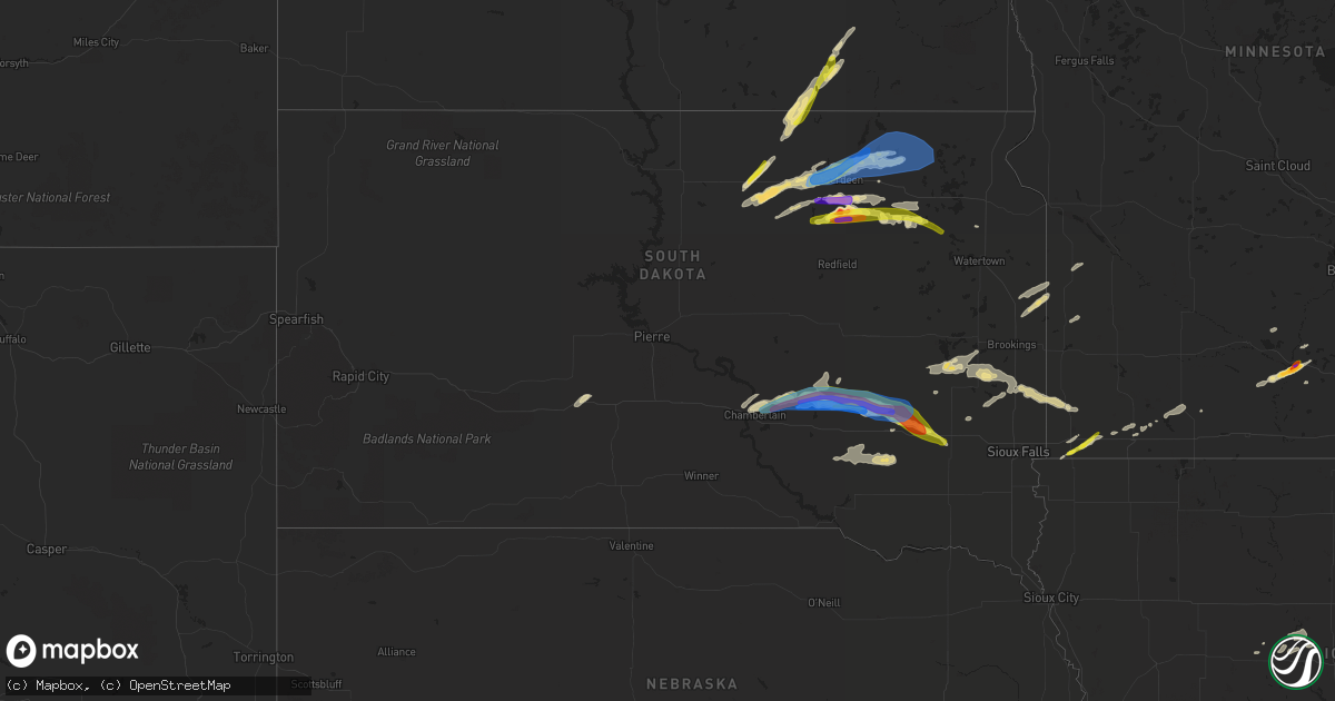
Hail Map in South Dakota on August 22, 2021
Get this storm
August 22 map
$229
one time, instant access
Download today. No call, no setup
Keep the $229
Bought the map and want the full workflow? Apply the entire $229 to a subscription within 7 days. None of it is wasted.
Every map, not just this one
This buys you this map. Subscription and you get every map we run, in the markets you choose from a few cities to whole states to nationwide. Plus real-time alerts the moment a storm fires.
Contact data
Name, contact info, occupancy, even credit band for addresses in the footprint. You go from where it hit to who to call.
Become the source they trust
Unlimited branding weather history reports on demand. You already have the documented answer ready for the property owner, and you are the one who showed up with it.
Property data and RoofTrace estimates
Pull up any address you have got, its value and the exact code rules for that jurisdiction, straight from One Click Code. Then RoofTrace estimates the squares, pitch, and roof value, priced the way you price.
Storm reports in South Dakota
South Dakota
| Date | Description |
|---|---|
| 08/22/20216:48 PM CDT | A local report indicates 1.00 inch wind near 7 NNW BRENTFORD |
| 08/22/20216:40 PM CDT | Many 1-1.5 inch diameter hail with the largest stones 2-2.25 inch diameter. |
| 08/22/20216:39 PM CDT | Delayed report. |
| 08/22/20216:36 PM CDT | Largest stone found... Many smaller stones too time estimated with radar data. |
| 08/22/20216:35 PM CDT | A local report indicates 1.75 inch wind near 10 N PLANKINTON |
| 08/22/20216:35 PM CDT | Aurora em estimated 80 to 90 mph wind gust. |
| 08/22/20216:25 PM CDT | A local report indicates 58 MPH wind near LANGFORD |
| 08/22/20216:24 PM CDT | A local report indicates 1.25 inch wind near WARNER |
| 08/22/20216:15 PM CDT | Power lines down near intersection of 8th ave n and n roosevelt road. Report relayed via social media. |
| 08/22/20216:00 PM CDT | 6 to 7 inch branches downed. |
| 08/22/20215:57 PM CDT | Large trees down... Major crop damage. |
| 08/22/20215:45 PM CDT | Leaning power polls... Large branches down. |
| 08/22/20215:44 PM CDT | A local report indicates 79 MPH wind near 3 N ABERDEEN |
| 08/22/20215:38 PM CDT | A local report indicates 1.00 inch wind near RICHMOND LAKE REC AREA |
| 08/22/20215:34 PM CDT | Time estimated based on radar. Brown county landfill shop #2. |
| 08/22/20215:33 PM CDT | A local report indicates 80 MPH wind near 5 S RICHMOND LAKE REC A |
| 08/22/20215:32 PM CDT | A local report indicates 1.00 inch wind near 4 E CRAVENS CORNER |
| 08/22/20215:30 PM CDT | Time estimated based on radar. |
| 08/22/20215:29 PM CDT | A local report indicates 75 MPH wind near 1 N MINA |
| 08/22/20214:58 PM CDT | A local report indicates 1.75 inch wind near 5 NNE LOYALTON |
| 08/22/20214:33 PM CDT | Delayed report. Small outbuilding destroyed by wind. Relayed via social media with photo. Estimated time. |
| 08/22/20213:32 AM CDT | At 832 PM CDT, a severe thunderstorm was located over Spencer In McCook County, or 20 miles east of Mitchell, moving east at 45 mph. HAZARD...Ping pong ball size hail and 60 mph wind gusts. SOURCE...Radar indicated. IMPACT...People and animals outdoors will be injured. Expect hail damage to roofs, siding, windows, and vehicles. Expect wind damage to roofs, siding, and trees. This severe thunderstorm will be near... Spencer In McCook County around 835 PM CDT. Salem around 850 PM CDT.Other locations in the path of this severe thunderstorm includeCanistota, Montrose and Lake Vermillion State Recreation Area. |
| 08/22/20213:06 AM CDT | At 805 PM CDT, a severe thunderstorm was located near Loomis, or 7 miles north of Mitchell, moving east at 30 mph. HAZARD...Golf ball size hail and 70 mph wind gusts. SOURCE...Trained weather spotters. IMPACT...People and animals outdoors will be injured. Expect hail damage to roofs, siding, windows, and vehicles. Expect considerable tree damage. Wind damage is also likely to mobile homes, roofs, and outbuildings. This severe thunderstorm will be near... Fulton around 825 PM CDT. Farmer around 840 PM CDT. |
| 08/22/20212:31 AM CDT | At 731 PM CDT, a severe thunderstorm was located over Storla, or 11 miles northeast of Plankinton, moving east at 30 mph. HAZARD...Golf ball size hail and 60 mph wind gusts. SOURCE...Radar indicated. IMPACT...People and animals outdoors will be injured. Expect hail damage to roofs, siding, windows, and vehicles. Expect wind damage to roofs, siding, and trees. This severe thunderstorm will be near... Letcher around 755 PM CDT. Loomis around 800 PM CDT. Mitchell around 805 PM CDT. |
| 08/22/20212:21 AM CDT | At 721 PM CDT, a severe thunderstorm was located 9 miles west of Storla, or 11 miles north of Plankinton, moving east at 35 mph. HAZARD...60 mph wind gusts and half dollar size hail. SOURCE...Radar indicated. IMPACT...Hail damage to vehicles is expected. Expect wind damage to roofs, siding, and trees. This severe thunderstorm will be near... Storla around 735 PM CDT. |
| 08/22/20212:17 AM CDT | At 717 PM CDT, a severe thunderstorm was located over Bristol, or 12 miles west of Webster, moving east at 35 mph. HAZARD...60 mph wind gusts and quarter size hail. SOURCE...Radar indicated. IMPACT...Hail damage to vehicles is expected. Expect wind damage to roofs, siding, and trees. This severe thunderstorm will be near... Butler around 720 PM CDT.Other locations in the path of this severe thunderstorm includeWebster, Antelope Lake, Rush Lake, Minnewasta Lake, Waubay Lake,Waubay, Blue Dog Lake, Bitter Lake, Waubay Wildlife Rec Area, EnemySwim Housing and Campbell Slough. |
| 08/22/20212:15 AM CDT | At 714 PM CDT, a severe thunderstorm was located near Loomis, or 8 miles north of Mitchell, moving east at 45 mph. HAZARD...Two inch hail and 70 mph wind gusts. SOURCE...Radar indicated. IMPACT...People and animals outdoors will be injured. Expect hail damage to roofs, siding, windows, and vehicles. Expect considerable tree damage. Wind damage is also likely to mobile homes, roofs, and outbuildings. This severe thunderstorm will be near... Fulton around 730 PM CDT.Other locations in the path of this severe thunderstorm includeFarmer. |
| 08/22/20211:27 AM CDT | At 627 PM CDT, a severe thunderstorm was located over Mansfield, or 18 miles south of Aberdeen, moving east at 35 mph. HAZARD...Ping pong ball size hail and 60 mph wind gusts. SOURCE...Radar indicated. IMPACT...People and animals outdoors will be injured. Expect hail damage to roofs, siding, windows, and vehicles. Expect wind damage to roofs, siding, and trees. Locations impacted include... Stratford, Verdon and Ferney. |
| 08/22/20211:23 AM CDT | At 623 PM CDT, a severe thunderstorm was located 10 miles north of White Lake, or 15 miles northwest of Plankinton, moving east at 30 mph. HAZARD...Tennis ball size hail and 70 mph wind gusts. SOURCE...Radar indicated. IMPACT...People and animals outdoors will be injured. Expect hail damage to roofs, siding, windows, and vehicles. Expect considerable tree damage. Wind damage is also likely to mobile homes, roofs, and outbuildings. Locations impacted include... Storla. |
| 08/22/20211:14 AM CDT | At 614 PM CDT, a severe thunderstorm was located near Claremont, or 12 miles north of Groton, moving east at 40 mph. THIS IS A DESTRUCTIVE STORM FOR PORTIONS OF DAY AND MARSHALL COUNTIES. HAZARD...80 mph wind gusts and quarter size hail. SOURCE...Emergency management. IMPACT...Flying debris will be dangerous to those caught without shelter. Mobile homes will be heavily damaged. Expect considerable damage to roofs, windows, and vehicles. Extensive tree damage and power outages are likely. This severe thunderstorm will be near... Langford and Amherst around 625 PM CDT.Other locations in the path of this severe thunderstorm include FortSisseton State Park, Cattail Lake and Roy Lake Rec Area. |
| 08/22/20211:11 AM CDT | At 611 PM CDT, a severe thunderstorm was located near North Scatterwood Lake, or 14 miles southwest of Aberdeen, moving east at 35 mph. HAZARD...60 mph wind gusts and half dollar size hail. SOURCE...Radar indicated. IMPACT...Hail damage to vehicles is expected. Expect wind damage to roofs, siding, and trees. This severe thunderstorm will be near... Mansfield around 615 PM CDT. Warner around 625 PM CDT. Aberdeen around 630 PM CDT.Other locations in the path of this severe thunderstorm include Bathand Stratford. |
| 08/22/202112:48 AM CDT | At 547 PM CDT, a severe thunderstorm was located near Gann Valley, or 13 miles north of Kimball, moving east at 35 mph. HAZARD...60 mph wind gusts and half dollar size hail. SOURCE...Radar indicated. IMPACT...Hail damage to vehicles is expected. Expect wind damage to roofs, siding, and trees. This severe thunderstorm will be near... Wessington Springs around 630 PM CDT. |
| 08/22/202112:40 AM CDT | At 539 PM CDT, a severe thunderstorm was located near Aberdeen, moving east at 45 mph. HAZARD...70 mph wind gusts and quarter size hail. SOURCE...Trained weather spotters. At 530 PM CDT, a 74 mph wind gust was reported at Mina Lake. IMPACT...Hail damage to vehicles is expected. Expect considerable tree damage. Wind damage is also likely to mobile homes, roofs, and outbuildings. This severe thunderstorm will be near... Aberdeen around 545 PM CDT. Bath around 555 PM CDT.Other locations in the path of this severe thunderstorm includeColumbia, Tacoma Park, Putney, Groton and Claremont. |
| 08/22/202112:25 AM CDT | At 524 PM CDT, a severe thunderstorm was located near Crow Creek Housing, or 9 miles northeast of Chamberlain, moving northeast at 45 mph. HAZARD...60 mph wind gusts and quarter size hail. SOURCE...Radar indicated. IMPACT...Hail damage to vehicles is expected. Expect wind damage to roofs, siding, and trees. Locations impacted include... Gann Valley. |
| 08/22/202112:21 AM CDT | At 521 PM CDT, a severe thunderstorm was located over Cravens Corner, or near Ipswich, moving northeast at 35 mph. HAZARD...60 mph wind gusts and quarter size hail. SOURCE...Radar indicated. IMPACT...Hail damage to vehicles is expected. Expect wind damage to roofs, siding, and trees. This severe thunderstorm will be near... Cravens Corner around 525 PM CDT. Mina around 535 PM CDT. Mina Lake Rec Area around 540 PM CDT.Other locations in the path of this severe thunderstorm includeRichmond Lake Rec Area. |
| 08/22/202112:15 AM CDT | At 515 PM CDT, a severe thunderstorm was located near Oacoma, or near Chamberlain, moving east at 45 mph. HAZARD...Ping pong ball size hail and 60 mph wind gusts. SOURCE...Radar indicated. IMPACT...People and animals outdoors will be injured. Expect hail damage to roofs, siding, windows, and vehicles. Expect wind damage to roofs, siding, and trees. This severe thunderstorm will remain over mainly rural areas of northern Brule County, including the following locations... Pukwana. |
| 08/21/202111:33 PM CDT | At 432 PM CDT, a severe thunderstorm was located over Roscoe, or 15 miles west of Ipswich, moving northeast at 45 mph. HAZARD...Two inch hail and 60 mph wind gusts. SOURCE...Radar indicated. IMPACT...People and animals outdoors will be injured. Expect hail damage to roofs, siding, windows, and vehicles. Expect wind damage to roofs, siding, and trees. Locations impacted include... Leola. |
| 08/21/202111:19 PM CDT | At 419 PM CDT, a severe thunderstorm was located over Tolstoy, or 21 miles northeast of Gettysburg, moving northeast at 35 mph. HAZARD...60 mph wind gusts and quarter size hail. SOURCE...Radar indicated. IMPACT...Hail damage to vehicles is expected. Expect wind damage to roofs, siding, and trees. This severe thunderstorm will be near... Onaka around 430 PM CDT.Other locations in the path of this severe thunderstorm includeLoyalton and Roscoe. |
| 08/21/20217:55 PM CDT | A local report indicates a tornado near 7 ENE LILY |
| 08/21/20217:48 PM CDT | A local report indicates 1.00 inch wind near 3 SW LETCHER |
| 08/21/20217:18 PM CDT | Time estimated based on radar. |
All States Impacted by Hail Map on August 22, 2021
Cities Impacted by Hail Map on August 22, 2021
- Drake, ND
- Balfour, ND
- Groton, SD
- Columbia, SD
- Roscoe, SD
- Plankinton, SD
- Letcher, SD
- Wessington Springs, SD
- Leola, SD
- Ellendale, ND
- Long Lake, SD
- Ashley, ND
- Forbes, ND
- Stamford, NE
- Beaver City, NE
- Hendley, NE
- Oberlin, KS
- McCook, NE
- Danbury, NE
- Wilsonville, NE
- Lebanon, NE
- Amherst, NE
- Mansfield, SD
- Warner, SD
- Mellette, SD
- Stratford, SD
- Conde, SD
- Sykeston, ND
- Bowdon, ND
- Star City, AR
- Elida, NM
- Hannaford, ND
- Glenfield, ND
- Sutton, ND
- Courtenay, ND
- Cooperstown, ND
- Wimbledon, ND
- Atlanta, NE
- Agra, KS
- Phillipsburg, KS
- Alexandria, SD
- Mitchell, SD
- Fulton, SD
- Gloucester, VA
- Bladen, NE
- Clemons, IA
- Mountain Lake, MN
- Parkersburg, IA
- New Hartford, IA
- Miller, NE
- Pleasanton, NE
- Ipswich, SD
- Jefferson, IA
- Hudson, IA
- Traer, IA
- Buckingham, IA
- Worthington, MN
- Reading, MN
- Lake Crystal, MN
- Garden City, MN
- Chamberlain, SD
- Tolna, ND
- Pekin, ND
- Mankato, MN
- Magdalena, NM
- Dimock, SD
- Franklin, NE
- Riverton, NE
- Campbell, NE
- Jasper, MN
- Pipestone, MN
- Webster, SD
- Waverly, VA
- Park, KS
- Grainfield, KS
- Canby, MN
- Brandt, SD
- Astoria, SD
- Belvidere, SD
- Okaton, SD
- Ogden, IA
- Boone, IA
- Pilot Mound, IA
- Northville, SD
- Aberdeen, SD
- New Rockford, ND
- Carrington, ND
- Stickney, SD
- Parkston, SD
- Corsica, SD
- Ethan, SD
- Mount Vernon, SD
- Republican City, NE
- Long Island, KS
- Naponee, NE
- Alma, NE
- Almena, KS
- Smith Center, KS
- Bloomington, NE
- Orleans, NE
- Norton, KS
- Red Cloud, NE
- Edison, NE
- Oxford, NE
- Indianola, NE
- Arapahoe, NE
- Inavale, NE
- Holbrook, NE
- Lebanon, KS
- Esbon, KS
- Milford, VA
- Tappahannock, VA
- Howard, SD
- Harvey, ND
- Reinbeck, IA
- Sumner, NE
- Warren, AR
- Hudgins, VA
- Gwynn, VA
- Allison, IA
- Clarksville, IA
- Lorton, VA
- Deshler, NE
- Hardy, NE
- Republic, KS
- Byron, NE
- Oacoma, SD
- Boelus, NE
- Saint Paul, NE
- Dannebrog, NE
- Santa Rosa, NM
- Mchenry, ND
- Heron Lake, MN
- Windom, MN
- Pukwana, SD
- Loup City, NE
- Rockville, NE
- Brewster, MN
- Ravenna, NE
- Kensal, ND
- Martin, ND
- Binford, ND
- Ivanhoe, MN
- Mankato, KS
- Edgeley, ND
- Bristol, SD
- Burr Oak, KS
- Van Horne, IA
- Topping, VA
- Claremont, SD
- Bath, SD
- Williamsburg, VA
- Ashton, NE
- Rutland, SD
- Madison, SD
- Goodrich, ND
- Good Thunder, MN
- Dana, IA
- Elba, NE
- Westport, SD
- Langford, SD
- Lower Brule, SD
- Reliance, SD
- Magnolia, MN
- Kanaranzi, MN
- Adrian, MN
- Parksley, VA
- Esmond, ND
- Upland, NE
- Toledo, IA
- Clutier, IA
- Victoria, VA
- Aneta, ND
- Petersburg, ND
- Niagara, ND
- Mcville, ND
- Holdrege, NE
- Cresbard, SD
- Faulkton, SD
- Eagle Lake, MN
- Kimball, SD
- Gann Valley, SD
- Dysart, IA
- Litchfield, NE
- Hazard, NE
- Ackley, IA
- Aplington, IA
- Kesley, IA
- Champlain, VA
- Hopewell, VA
- Prince George, VA
- Bertrand, NE
- Smithfield, NE
- Hardwick, MN
- Edgerton, MN
- Deltaville, VA
- Kilmarnock, VA
- Disputanta, VA
- Petersburg, VA
- Webber, KS
- Norcatur, KS
- Formoso, KS
- Blue Hill, NE
- Superior, NE
- Cambridge, NE
- Guide Rock, NE
- Berlin, ND
- Elwood, NE
- Gary, SD
- Clear Lake, SD
- Sunbury, NC
- Belvidere, NC
- Hobbsville, NC
- Saint Anthony, IA
- Steen, MN
- Madison, MN
- Woonsocket, SD
- White Lake, SD
- Perryville, AR
- Trent, SD
- Flandreau, SD
- Egan, SD
- Bohannon, VA
- Cardinal, VA
- Dutton, VA
- North, VA
- Foster, VA
- Mathews, VA
- Port Haywood, VA
- Montevideo, MN
- Hickory, MS
- Chunky, MS
- Hildreth, NE
- Newark, MD
- Ramona, SD
- Wentworth, SD
- Nunda, SD
- Winfred, SD
- Oldham, SD
- Shacklefords, VA
- Toano, VA
- Mattaponi, VA
- Barhamsville, VA
- Holcomb, KS
- Lamoure, ND
- Marion, ND
- Dickey, ND
- White, SD
- Toronto, SD
- Perry, OK
- Morrison, OK
- Overton, NE
- Lancaster, VA
- Weems, VA
- Larimore, ND
- Saint Peter, MN
- Nicollet, MN
- Roswell, NM
- Andover, SD
- Minden, NE
- Ellsworth, MN
- Luverne, MN
- Madison Lake, MN
- Madelia, MN
- Waverly, IA
- Shell Rock, IA
- Dike, IA
- Grundy Center, IA
- Kenbridge, VA
- Lunenburg, VA
- Colman, SD
- Carthage, SD
- Arlington, SD
- Chester, NE
- Chester, SD
- Appomattox, VA
- Dawson, MN
- Farnham, VA
- Heathsville, VA
- Rushmore, MN
- Farwell, NE
- Malvern, AR
- Poyen, AR
- Cleveland, MN
- Kasota, MN
- Houston, AR
- Dinwiddie, VA
- Garrison, IA
- Ferney, SD
- Laneview, VA
- Center Cross, VA
- Mascot, VA
- Little Plymouth, VA
- Fairfax, IA
- Atkins, IA
- Paton, IA
- Loomis, NE
- Stratford, IA
- Dayton, IA
- Hoxie, KS
- Surry, VA
- Wilcox, NE
- Bridgewater, SD
- Canistota, SD
- Spencer, SD
- Dewitt, VA
- McKenney, VA
- Maddock, ND
- South Shore, SD
- Fullerton, ND
- Holstein, NE
- Chincoteague Island, VA
- Hills, MN
- Rose Hill, MS
- Grinnell, KS
- Deerfield, KS
- Garden City, KS
- Fort Belvoir, VA
- Bloxom, VA
- Hayes, VA
- Montrose, SD
- Oakley, KS
- Melfa, VA
- Painter, VA
- Wilsons, VA
- Boynton, OK
- Morris, OK
- Accomac, VA
- Cathay, ND
- Grace City, ND
- Hosmer, SD
- Wallace, SD
- Brentford, SD
- Bradley, SD
- Emery, SD
- Canova, SD
- Fedora, SD
- Artesian, SD
- Eden, SD
- Britton, SD
- Houghton, SD
- Roslyn, SD
- Amherst, SD
- Pierpont, SD
- Block Island, RI
- Carolina, RI
- Kingston, RI
- Little Compton, RI
- Middletown, RI
- Rockville, RI
- Wakefield, RI
- Wood River Junction, RI
- Tiverton, RI
- Jamestown, RI
- Exeter, RI
- Wyoming, RI
- Hope Valley, RI
- Ashaway, RI
- Narragansett, RI
- Newport, RI
- Shannock, RI
- North Kingstown, RI
- Bradford, RI
- Hopkinton, RI
- Prudence Island, RI
- Portsmouth, RI
- Saunderstown, RI
- Voluntown, CT
- Kenyon, RI
- West Kingston, RI
- Charlestown, RI
- North Stonington, CT
- Kensington, KS


