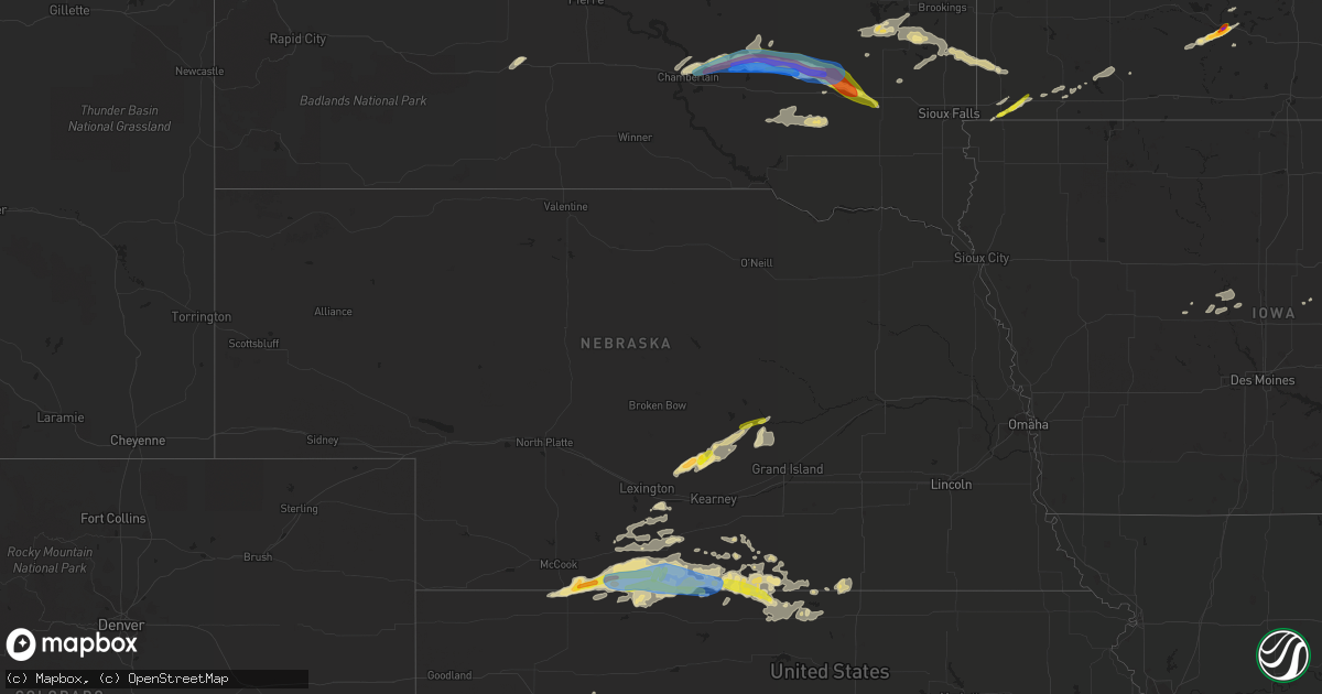
Hail Map in Nebraska on August 22, 2021
Get this storm
August 22 map
$229
one time, instant access
Download today. No call, no setup
Keep the $229
Bought the map and want the full workflow? Apply the entire $229 to a subscription within 7 days. None of it is wasted.
Every map, not just this one
This buys you this map. Subscription and you get every map we run, in the markets you choose from a few cities to whole states to nationwide. Plus real-time alerts the moment a storm fires.
Contact data
Name, contact info, occupancy, even credit band for addresses in the footprint. You go from where it hit to who to call.
Become the source they trust
Unlimited branding weather history reports on demand. You already have the documented answer ready for the property owner, and you are the one who showed up with it.
Property data and RoofTrace estimates
Pull up any address you have got, its value and the exact code rules for that jurisdiction, straight from One Click Code. Then RoofTrace estimates the squares, pitch, and roof value, priced the way you price.
Storm reports in Nebraska
Nebraska
| Date | Description |
|---|---|
| 08/22/20216:42 PM CDT | A local report indicates 65 MPH wind near 5 NE STAMFORD |
| 08/22/20216:38 PM CDT | Tree damage reported on the north side of town. Time estimated from radar. |
| 08/22/20216:04 PM CDT | Report of quarter size hail on hwy 283 approximately 3 miles north of the ne/ks state line. |
| 08/22/20216:00 PM CDT | Wind gusts estimated to be near 65 mph at hwy 89 and 283 intersection. |
| 08/22/20215:57 PM CDT | Measured gusts of 68 and 71 mph reported. |
| 08/22/20215:50 PM CDT | A local report indicates 1.50 inch wind near 2 S WILSONVILLE |
| 08/22/20215:46 PM CDT | A local report indicates 1.00 inch wind near 3 WSW STAMFORD |
| 08/22/20215:21 PM CDT | Spotter reported mostly pea to quarter sized hail with sporadic ping pong sized hail mixed in. |
| 08/22/20215:15 PM CDT | Caller reported sporadic dime to quarter sized hail. Time estimated by radar. |
| 08/22/20213:57 AM CDT | At 857 PM CDT, a severe thunderstorm was located near Orleans, or 15 miles south of Holdrege, moving east at 30 mph. HAZARD...60 mph wind gusts and quarter size hail. SOURCE...Public. A mesonet station near Orleans reported a 63 mph wind gust at 853 PM CDT. IMPACT...Hail damage to vehicles is expected. Expect wind damage to roofs, siding, and trees. This severe thunderstorm will be near... Huntley around 910 PM CDT. Ragan around 915 PM CDT.Other locations in the path of this severe thunderstorm includeWilcox and Hildreth. |
| 08/22/20213:31 AM CDT | At 831 PM CDT, a severe thunderstorm was located 7 miles south of Inavale, or 38 miles northeast of Phillipsburg, moving east at 35 mph. HAZARD...60 mph wind gusts and quarter size hail. SOURCE...Radar indicated. IMPACT...Hail damage to vehicles is expected. Expect wind damage to roofs, siding, and trees. This severe thunderstorm will be near... Red Cloud around 845 PM CDT.Other locations in the path of this severe thunderstorm include GuideRock, Burr Oak, Superior and Bostwick. |
| 08/22/20213:21 AM CDT | At 821 PM CDT, a severe thunderstorm was located over Farwell, or 22 miles northwest of Grand Island, moving northeast at 30 mph. HAZARD...60 mph wind gusts and quarter size hail. SOURCE...Emergency management. IMPACT...Hail damage to vehicles is expected. Expect wind damage to roofs, siding, and trees. This severe thunderstorm will be near... St. Paul around 830 PM CDT.Other locations in the path of this severe thunderstorm includeCushing and Palmer. |
| 08/22/20212:43 AM CDT | At 743 PM CDT, a severe thunderstorm was located near Woodruff, or 18 miles north of Phillipsburg, moving east at 20 mph. HAZARD...60 mph wind gusts and quarter size hail. SOURCE...Radar indicated. IMPACT...Hail damage to vehicles is expected. Expect wind damage to roofs, siding, and trees. Locations impacted include... Republican City, Harlan County Dam, Naponee and Bloomington. |
| 08/22/20212:39 AM CDT | At 739 PM CDT, a severe thunderstorm was located over Miller, or 22 miles northwest of Kearney, moving northeast at 20 mph. HAZARD...60 mph wind gusts and quarter size hail. SOURCE...Radar indicated. IMPACT...Hail damage to vehicles is expected. Expect wind damage to roofs, siding, and trees. Locations impacted include... Pleasanton, Litchfield and Hazard. |
| 08/22/20211:19 AM CDT | At 618 PM CDT, a severe thunderstorm was located near Stamford, or 20 miles southwest of Holdrege, moving northeast at 20 mph. HAZARD...60 mph wind gusts and quarter size hail. SOURCE...Radar indicated. IMPACT...Hail damage to vehicles is expected. Expect wind damage to roofs, siding, and trees. This severe thunderstorm will be near... Orleans around 630 PM CDT.Other locations in the path of this severe thunderstorm includeHuntley and Ragan. |
| 08/22/202112:46 AM CDT | At 545 PM CDT, a severe thunderstorm was located near Stamford, or 21 miles northeast of Norton, moving north at 15 mph. HAZARD...60 mph wind gusts and quarter size hail. SOURCE...Radar indicated. IMPACT...Hail damage to vehicles is expected. Expect wind damage to roofs, siding, and trees. This severe thunderstorm will be near... Hollinger around 555 PM CDT. Stamford around 600 PM CDT.Other locations in the path of this severe thunderstorm includeOxford. |
| 08/22/202112:03 AM CDT | At 503 PM CDT, a severe thunderstorm was located near Herndon, or 14 miles northwest of Oberlin, moving east at 25 mph. HAZARD...Half dollar size hail. SOURCE...Radar indicated. IMPACT...Damage to vehicles is expected. Locations impacted include... Danbury and Lebanon. |
| 08/21/202111:30 PM CDT | Davis weatherlink station. |
| 08/21/202110:00 PM CDT | Dispatch reported quarter size hail in town. |
| 08/21/20219:01 PM CDT | Two trees downed in alma. Report from harlan county dispatch. Time estimated from radar. |
| 08/21/20218:53 PM CDT | A local report indicates 63 MPH wind near 6 NW ORLEANS |
| 08/21/20218:09 PM CDT | A local report indicates 1.00 inch wind near ASHTON |
| 08/21/20217:55 PM CDT | Report relayed via ntv. |
All States Impacted by Hail Map on August 22, 2021
Cities Impacted by Hail Map on August 22, 2021
- Drake, ND
- Balfour, ND
- Groton, SD
- Columbia, SD
- Roscoe, SD
- Plankinton, SD
- Letcher, SD
- Wessington Springs, SD
- Leola, SD
- Ellendale, ND
- Long Lake, SD
- Ashley, ND
- Forbes, ND
- Stamford, NE
- Beaver City, NE
- Hendley, NE
- Oberlin, KS
- McCook, NE
- Danbury, NE
- Wilsonville, NE
- Lebanon, NE
- Amherst, NE
- Mansfield, SD
- Warner, SD
- Mellette, SD
- Stratford, SD
- Conde, SD
- Sykeston, ND
- Bowdon, ND
- Star City, AR
- Elida, NM
- Hannaford, ND
- Glenfield, ND
- Sutton, ND
- Courtenay, ND
- Cooperstown, ND
- Wimbledon, ND
- Atlanta, NE
- Agra, KS
- Phillipsburg, KS
- Alexandria, SD
- Mitchell, SD
- Fulton, SD
- Gloucester, VA
- Bladen, NE
- Clemons, IA
- Mountain Lake, MN
- Parkersburg, IA
- New Hartford, IA
- Miller, NE
- Pleasanton, NE
- Ipswich, SD
- Jefferson, IA
- Hudson, IA
- Traer, IA
- Buckingham, IA
- Worthington, MN
- Reading, MN
- Lake Crystal, MN
- Garden City, MN
- Chamberlain, SD
- Tolna, ND
- Pekin, ND
- Mankato, MN
- Magdalena, NM
- Dimock, SD
- Franklin, NE
- Riverton, NE
- Campbell, NE
- Jasper, MN
- Pipestone, MN
- Webster, SD
- Waverly, VA
- Park, KS
- Grainfield, KS
- Canby, MN
- Brandt, SD
- Astoria, SD
- Belvidere, SD
- Okaton, SD
- Ogden, IA
- Boone, IA
- Pilot Mound, IA
- Northville, SD
- Aberdeen, SD
- New Rockford, ND
- Carrington, ND
- Stickney, SD
- Parkston, SD
- Corsica, SD
- Ethan, SD
- Mount Vernon, SD
- Republican City, NE
- Long Island, KS
- Naponee, NE
- Alma, NE
- Almena, KS
- Smith Center, KS
- Bloomington, NE
- Orleans, NE
- Norton, KS
- Red Cloud, NE
- Edison, NE
- Oxford, NE
- Indianola, NE
- Arapahoe, NE
- Inavale, NE
- Holbrook, NE
- Lebanon, KS
- Esbon, KS
- Milford, VA
- Tappahannock, VA
- Howard, SD
- Harvey, ND
- Reinbeck, IA
- Sumner, NE
- Warren, AR
- Hudgins, VA
- Gwynn, VA
- Allison, IA
- Clarksville, IA
- Lorton, VA
- Deshler, NE
- Hardy, NE
- Republic, KS
- Byron, NE
- Oacoma, SD
- Boelus, NE
- Saint Paul, NE
- Dannebrog, NE
- Santa Rosa, NM
- Mchenry, ND
- Heron Lake, MN
- Windom, MN
- Pukwana, SD
- Loup City, NE
- Rockville, NE
- Brewster, MN
- Ravenna, NE
- Kensal, ND
- Martin, ND
- Binford, ND
- Ivanhoe, MN
- Mankato, KS
- Edgeley, ND
- Bristol, SD
- Burr Oak, KS
- Van Horne, IA
- Topping, VA
- Claremont, SD
- Bath, SD
- Williamsburg, VA
- Ashton, NE
- Rutland, SD
- Madison, SD
- Goodrich, ND
- Good Thunder, MN
- Dana, IA
- Elba, NE
- Westport, SD
- Langford, SD
- Lower Brule, SD
- Reliance, SD
- Magnolia, MN
- Kanaranzi, MN
- Adrian, MN
- Parksley, VA
- Esmond, ND
- Upland, NE
- Toledo, IA
- Clutier, IA
- Victoria, VA
- Aneta, ND
- Petersburg, ND
- Niagara, ND
- Mcville, ND
- Holdrege, NE
- Cresbard, SD
- Faulkton, SD
- Eagle Lake, MN
- Kimball, SD
- Gann Valley, SD
- Dysart, IA
- Litchfield, NE
- Hazard, NE
- Ackley, IA
- Aplington, IA
- Kesley, IA
- Champlain, VA
- Hopewell, VA
- Prince George, VA
- Bertrand, NE
- Smithfield, NE
- Hardwick, MN
- Edgerton, MN
- Deltaville, VA
- Kilmarnock, VA
- Disputanta, VA
- Petersburg, VA
- Webber, KS
- Norcatur, KS
- Formoso, KS
- Blue Hill, NE
- Superior, NE
- Cambridge, NE
- Guide Rock, NE
- Berlin, ND
- Elwood, NE
- Gary, SD
- Clear Lake, SD
- Sunbury, NC
- Belvidere, NC
- Hobbsville, NC
- Saint Anthony, IA
- Steen, MN
- Madison, MN
- Woonsocket, SD
- White Lake, SD
- Perryville, AR
- Trent, SD
- Flandreau, SD
- Egan, SD
- Bohannon, VA
- Cardinal, VA
- Dutton, VA
- North, VA
- Foster, VA
- Mathews, VA
- Port Haywood, VA
- Montevideo, MN
- Hickory, MS
- Chunky, MS
- Hildreth, NE
- Newark, MD
- Ramona, SD
- Wentworth, SD
- Nunda, SD
- Winfred, SD
- Oldham, SD
- Shacklefords, VA
- Toano, VA
- Mattaponi, VA
- Barhamsville, VA
- Holcomb, KS
- Lamoure, ND
- Marion, ND
- Dickey, ND
- White, SD
- Toronto, SD
- Perry, OK
- Morrison, OK
- Overton, NE
- Lancaster, VA
- Weems, VA
- Larimore, ND
- Saint Peter, MN
- Nicollet, MN
- Roswell, NM
- Andover, SD
- Minden, NE
- Ellsworth, MN
- Luverne, MN
- Madison Lake, MN
- Madelia, MN
- Waverly, IA
- Shell Rock, IA
- Dike, IA
- Grundy Center, IA
- Kenbridge, VA
- Lunenburg, VA
- Colman, SD
- Carthage, SD
- Arlington, SD
- Chester, NE
- Chester, SD
- Appomattox, VA
- Dawson, MN
- Farnham, VA
- Heathsville, VA
- Rushmore, MN
- Farwell, NE
- Malvern, AR
- Poyen, AR
- Cleveland, MN
- Kasota, MN
- Houston, AR
- Dinwiddie, VA
- Garrison, IA
- Ferney, SD
- Laneview, VA
- Center Cross, VA
- Mascot, VA
- Little Plymouth, VA
- Fairfax, IA
- Atkins, IA
- Paton, IA
- Loomis, NE
- Stratford, IA
- Dayton, IA
- Hoxie, KS
- Surry, VA
- Wilcox, NE
- Bridgewater, SD
- Canistota, SD
- Spencer, SD
- Dewitt, VA
- McKenney, VA
- Maddock, ND
- South Shore, SD
- Fullerton, ND
- Holstein, NE
- Chincoteague Island, VA
- Hills, MN
- Rose Hill, MS
- Grinnell, KS
- Deerfield, KS
- Garden City, KS
- Fort Belvoir, VA
- Bloxom, VA
- Hayes, VA
- Montrose, SD
- Oakley, KS
- Melfa, VA
- Painter, VA
- Wilsons, VA
- Boynton, OK
- Morris, OK
- Accomac, VA
- Cathay, ND
- Grace City, ND
- Hosmer, SD
- Wallace, SD
- Brentford, SD
- Bradley, SD
- Emery, SD
- Canova, SD
- Fedora, SD
- Artesian, SD
- Eden, SD
- Britton, SD
- Houghton, SD
- Roslyn, SD
- Amherst, SD
- Pierpont, SD
- Block Island, RI
- Carolina, RI
- Kingston, RI
- Little Compton, RI
- Middletown, RI
- Rockville, RI
- Wakefield, RI
- Wood River Junction, RI
- Tiverton, RI
- Jamestown, RI
- Exeter, RI
- Wyoming, RI
- Hope Valley, RI
- Ashaway, RI
- Narragansett, RI
- Newport, RI
- Shannock, RI
- North Kingstown, RI
- Bradford, RI
- Hopkinton, RI
- Prudence Island, RI
- Portsmouth, RI
- Saunderstown, RI
- Voluntown, CT
- Kenyon, RI
- West Kingston, RI
- Charlestown, RI
- North Stonington, CT
- Kensington, KS


