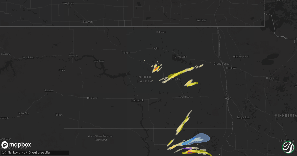
Hail Map in North Dakota on August 22, 2021
Get this storm
August 22 map
$229
one time, instant access
Download today. No call, no setup
Keep the $229
Bought the map and want the full workflow? Apply the entire $229 to a subscription within 7 days. None of it is wasted.
Every map, not just this one
This buys you this map. Subscription and you get every map we run, in the markets you choose from a few cities to whole states to nationwide. Plus real-time alerts the moment a storm fires.
Contact data
Name, contact info, occupancy, even credit band for addresses in the footprint. You go from where it hit to who to call.
Become the source they trust
Unlimited branding weather history reports on demand. You already have the documented answer ready for the property owner, and you are the one who showed up with it.
Property data and RoofTrace estimates
Pull up any address you have got, its value and the exact code rules for that jurisdiction, straight from One Click Code. Then RoofTrace estimates the squares, pitch, and roof value, priced the way you price.
Storm reports in North Dakota
North Dakota
| Date | Description |
|---|---|
| 08/22/20216:45 PM CDT | Pea to quarter sized hail. |
| 08/22/20216:30 PM CDT | Peas to quarters |
| 08/22/20216:10 PM CDT | Waterspout spotted on devils lake. Time estimated. No damage reported. |
| 08/22/20216:05 PM CDT | Pea to quarter sized hail. |
| 08/22/20216:02 PM CDT | Waterspout spotted on east bay of devils lake. No damage was noted. Time estimated. |
| 08/22/20216:02 PM CDT | Corrects previous tornado report from 4 e camp grafton. Waterspout spotted on devils lake. Time estimated. No damage reported. |
| 08/22/20216:01 PM CDT | Corrects previous hail report from 3 se new rockford. Peas to quarters |
| 08/22/20216:00 PM CDT | A local report indicates 1.50 inch wind near 6 N CARRINGTON |
| 08/22/20216:00 PM CDT | A local report indicates 1.75 inch wind near 3 SSE BARLOW |
| 08/22/20214:40 PM CDT | Corn blown down. Branches down. Report posted via social media. Time estimated based on radar. |
| 08/22/20214:40 PM CDT | Corn blown down. Large branches blown down. Report posted via social media. Time estimated based on radar. |
| 08/22/20214:17 PM CDT | Photo of large hail taken by the public was submitted by khnd radio. Hail had quite a few spikes on it. One inch of rain fell with the hail. Time estimated by radar. |
| 08/22/20212:54 AM CDT | At 754 PM CDT, a severe thunderstorm was located near Finley, or 36 miles north of Valley City, moving northeast at 30 mph. HAZARD...60 mph wind gusts and quarter size hail. SOURCE...Radar indicated. IMPACT...Hail damage to vehicles is expected. Expect wind damage to roofs, siding, and trees. This severe thunderstorm will be near... Finley around 805 PM CDT. Sherbrooke around 810 PM CDT. |
| 08/22/20212:40 AM CDT | At 740 PM CDT, a severe thunderstorm was located near Logan Center, or 37 miles west of Grand Forks, moving east at 30 mph. HAZARD...60 mph wind gusts and quarter size hail. SOURCE...Radar indicated. IMPACT...Hail damage to vehicles is expected. Expect wind damage to roofs, siding, and trees. This severe thunderstorm will remain over mainly rural areas of west central Grand Forks and east central Nelson Counties. |
| 08/22/20211:57 AM CDT | At 657 PM CDT, a severe thunderstorm was located over Red Iron Housing, or 14 miles west of Sisseton, moving east at 60 mph. HAZARD...70 mph wind gusts and quarter size hail. SOURCE...Radar indicated. IMPACT...Hail damage to vehicles is expected. Expect considerable tree damage. Wind damage is also likely to mobile homes, roofs, and outbuildings. This severe thunderstorm will be near... Sica Hollow State Park around 700 PM CDT. Long Hollow Housing around 705 PM CDT. Sisseton around 710 PM CDT. Dakota Connection & Casino around 715 PM CDT.Other locations in the path of this severe thunderstorm include NewEffington, Lake Traverse Housing Units, Victor, Rainbow Island,Traverse Country Park, Rosholt, Lake Traverse, Halls Landing, MudLake Landing, Silver Bridge and Whiterock Colony. |
| 08/22/20211:48 AM CDT | At 648 PM CDT, a severe thunderstorm was located near Sutton, or 36 miles northwest of Valley City, moving northeast at 30 mph. HAZARD...60 mph wind gusts and quarter size hail. SOURCE...Radar indicated. IMPACT...Hail damage to vehicles is expected. Expect wind damage to roofs, siding, and trees. This severe thunderstorm will be near... Sutton around 655 PM CDT. Revere around 700 PM CDT.Other locations in the path of this severe thunderstorm includeHannaford and Cooperstown. |
| 08/22/20211:37 AM CDT | At 637 PM CDT, a severe thunderstorm was located 9 miles south of Hamar, or 29 miles southeast of Devils Lake, moving northeast at 25 mph. HAZARD...60 mph wind gusts and half dollar size hail. SOURCE...Radar indicated. IMPACT...Hail damage to vehicles is expected. Expect wind damage to roofs, siding, and trees. Locations impacted include... Tolna and Pekin. |
| 08/22/202112:58 AM CDT | At 558 PM CDT, a severe thunderstorm was located over Barlow, or 39 miles south of Devils Lake, moving northeast at 45 mph. HAZARD...Two inch hail and 60 mph wind gusts. SOURCE...Radar indicated. IMPACT...People and animals outdoors will be injured. Expect hail damage to roofs, siding, windows, and vehicles. Expect wind damage to roofs, siding, and trees. This severe thunderstorm will be near... Brantford around 610 PM CDT. |
| 08/22/202112:14 AM CDT | At 514 PM CDT, severe thunderstorms were located along a line extending from near Cathay to 15 miles west of Carrington, moving east at 25 mph. HAZARD...Ping pong ball size hail and 60 mph wind gusts. SOURCE...Radar indicated. IMPACT...People and animals outdoors will be injured. Expect hail damage to roofs, siding, windows, and vehicles. Expect wind damage to roofs, siding, and trees. Locations impacted include... Carrington and Bordulac. |
| 08/22/202112:13 AM CDT | At 512 PM CDT, a severe thunderstorm was located 5 miles northwest of Forbes, or 16 miles west of Ellendale, moving northeast at 45 mph. HAZARD...Ping pong ball size hail and 60 mph wind gusts. SOURCE...Radar indicated. IMPACT...People and animals outdoors will be injured. Expect hail damage to roofs, siding, windows, and vehicles. Expect wind damage to roofs, siding, and trees. This severe thunderstorm will remain over mainly rural areas of western Dickey County, including the following locations... Monango and Merricourt. |
| 08/22/202112:03 AM CDT | At 503 PM CDT, a severe thunderstorm was located near Spring Creek Colony, or 22 miles southwest of Ellendale, moving northeast at 45 mph. HAZARD...60 mph wind gusts and half dollar size hail. SOURCE...Radar indicated. IMPACT...Hail damage to vehicles is expected. Expect wind damage to roofs, siding, and trees. This severe thunderstorm will be near... Forbes around 515 PM CDT. |
| 08/21/202111:19 PM CDT | At 418 PM CDT, a severe thunderstorm was located over Harvey, or 52 miles southwest of Devils Lake, moving northeast at 50 mph. HAZARD...60 mph wind gusts and quarter size hail. SOURCE...Radar indicated. IMPACT...Hail damage to vehicles is expected. Expect wind damage to roofs, siding, and trees. Locations impacted include... Maddock, Flora, Harlow, Brinsmade and Minnewaukan. |
| 08/21/202111:15 PM CDT | At 415 PM CDT, severe thunderstorms were located along a line extending from 8 miles southwest of Esmond to near Hurdsfield, moving northeast at 50 mph. HAZARD...Ping pong ball size hail and 60 mph wind gusts. SOURCE...Radar indicated. IMPACT...People and animals outdoors will be injured. Expect hail damage to roofs, siding, windows, and vehicles. Expect wind damage to roofs, siding, and trees. Locations impacted include... Fessenden. |
| 08/21/20217:35 PM CDT | A local report indicates 1.00 inch wind near 2 NE HANNAFORD |
| 08/21/20217:15 PM CDT | Golf ball hail reported north of town... With pea to quarter sized hail south of town. |
| 08/21/20217:00 PM CDT | 4 waves... Each with larger hail. Started as peas and turned to about half dollars. Damaged garden. |
| 08/21/20217:00 PM CDT | Four waves of hail... Each with larger hail stones. Started as ppeas and turned to about half dollar sized. Damaged garden. |
All States Impacted by Hail Map on August 22, 2021
Cities Impacted by Hail Map on August 22, 2021
- Drake, ND
- Balfour, ND
- Groton, SD
- Columbia, SD
- Roscoe, SD
- Plankinton, SD
- Letcher, SD
- Wessington Springs, SD
- Leola, SD
- Ellendale, ND
- Long Lake, SD
- Ashley, ND
- Forbes, ND
- Stamford, NE
- Beaver City, NE
- Hendley, NE
- Oberlin, KS
- McCook, NE
- Danbury, NE
- Wilsonville, NE
- Lebanon, NE
- Amherst, NE
- Mansfield, SD
- Warner, SD
- Mellette, SD
- Stratford, SD
- Conde, SD
- Sykeston, ND
- Bowdon, ND
- Star City, AR
- Elida, NM
- Hannaford, ND
- Glenfield, ND
- Sutton, ND
- Courtenay, ND
- Cooperstown, ND
- Wimbledon, ND
- Atlanta, NE
- Agra, KS
- Phillipsburg, KS
- Alexandria, SD
- Mitchell, SD
- Fulton, SD
- Gloucester, VA
- Bladen, NE
- Clemons, IA
- Mountain Lake, MN
- Parkersburg, IA
- New Hartford, IA
- Miller, NE
- Pleasanton, NE
- Ipswich, SD
- Jefferson, IA
- Hudson, IA
- Traer, IA
- Buckingham, IA
- Worthington, MN
- Reading, MN
- Lake Crystal, MN
- Garden City, MN
- Chamberlain, SD
- Tolna, ND
- Pekin, ND
- Mankato, MN
- Magdalena, NM
- Dimock, SD
- Franklin, NE
- Riverton, NE
- Campbell, NE
- Jasper, MN
- Pipestone, MN
- Webster, SD
- Waverly, VA
- Park, KS
- Grainfield, KS
- Canby, MN
- Brandt, SD
- Astoria, SD
- Belvidere, SD
- Okaton, SD
- Ogden, IA
- Boone, IA
- Pilot Mound, IA
- Northville, SD
- Aberdeen, SD
- New Rockford, ND
- Carrington, ND
- Stickney, SD
- Parkston, SD
- Corsica, SD
- Ethan, SD
- Mount Vernon, SD
- Republican City, NE
- Long Island, KS
- Naponee, NE
- Alma, NE
- Almena, KS
- Smith Center, KS
- Bloomington, NE
- Orleans, NE
- Norton, KS
- Red Cloud, NE
- Edison, NE
- Oxford, NE
- Indianola, NE
- Arapahoe, NE
- Inavale, NE
- Holbrook, NE
- Lebanon, KS
- Esbon, KS
- Milford, VA
- Tappahannock, VA
- Howard, SD
- Harvey, ND
- Reinbeck, IA
- Sumner, NE
- Warren, AR
- Hudgins, VA
- Gwynn, VA
- Allison, IA
- Clarksville, IA
- Lorton, VA
- Deshler, NE
- Hardy, NE
- Republic, KS
- Byron, NE
- Oacoma, SD
- Boelus, NE
- Saint Paul, NE
- Dannebrog, NE
- Santa Rosa, NM
- Mchenry, ND
- Heron Lake, MN
- Windom, MN
- Pukwana, SD
- Loup City, NE
- Rockville, NE
- Brewster, MN
- Ravenna, NE
- Kensal, ND
- Martin, ND
- Binford, ND
- Ivanhoe, MN
- Mankato, KS
- Edgeley, ND
- Bristol, SD
- Burr Oak, KS
- Van Horne, IA
- Topping, VA
- Claremont, SD
- Bath, SD
- Williamsburg, VA
- Ashton, NE
- Rutland, SD
- Madison, SD
- Goodrich, ND
- Good Thunder, MN
- Dana, IA
- Elba, NE
- Westport, SD
- Langford, SD
- Lower Brule, SD
- Reliance, SD
- Magnolia, MN
- Kanaranzi, MN
- Adrian, MN
- Parksley, VA
- Esmond, ND
- Upland, NE
- Toledo, IA
- Clutier, IA
- Victoria, VA
- Aneta, ND
- Petersburg, ND
- Niagara, ND
- Mcville, ND
- Holdrege, NE
- Cresbard, SD
- Faulkton, SD
- Eagle Lake, MN
- Kimball, SD
- Gann Valley, SD
- Dysart, IA
- Litchfield, NE
- Hazard, NE
- Ackley, IA
- Aplington, IA
- Kesley, IA
- Champlain, VA
- Hopewell, VA
- Prince George, VA
- Bertrand, NE
- Smithfield, NE
- Hardwick, MN
- Edgerton, MN
- Deltaville, VA
- Kilmarnock, VA
- Disputanta, VA
- Petersburg, VA
- Webber, KS
- Norcatur, KS
- Formoso, KS
- Blue Hill, NE
- Superior, NE
- Cambridge, NE
- Guide Rock, NE
- Berlin, ND
- Elwood, NE
- Gary, SD
- Clear Lake, SD
- Sunbury, NC
- Belvidere, NC
- Hobbsville, NC
- Saint Anthony, IA
- Steen, MN
- Madison, MN
- Woonsocket, SD
- White Lake, SD
- Perryville, AR
- Trent, SD
- Flandreau, SD
- Egan, SD
- Bohannon, VA
- Cardinal, VA
- Dutton, VA
- North, VA
- Foster, VA
- Mathews, VA
- Port Haywood, VA
- Montevideo, MN
- Hickory, MS
- Chunky, MS
- Hildreth, NE
- Newark, MD
- Ramona, SD
- Wentworth, SD
- Nunda, SD
- Winfred, SD
- Oldham, SD
- Shacklefords, VA
- Toano, VA
- Mattaponi, VA
- Barhamsville, VA
- Holcomb, KS
- Lamoure, ND
- Marion, ND
- Dickey, ND
- White, SD
- Toronto, SD
- Perry, OK
- Morrison, OK
- Overton, NE
- Lancaster, VA
- Weems, VA
- Larimore, ND
- Saint Peter, MN
- Nicollet, MN
- Roswell, NM
- Andover, SD
- Minden, NE
- Ellsworth, MN
- Luverne, MN
- Madison Lake, MN
- Madelia, MN
- Waverly, IA
- Shell Rock, IA
- Dike, IA
- Grundy Center, IA
- Kenbridge, VA
- Lunenburg, VA
- Colman, SD
- Carthage, SD
- Arlington, SD
- Chester, NE
- Chester, SD
- Appomattox, VA
- Dawson, MN
- Farnham, VA
- Heathsville, VA
- Rushmore, MN
- Farwell, NE
- Malvern, AR
- Poyen, AR
- Cleveland, MN
- Kasota, MN
- Houston, AR
- Dinwiddie, VA
- Garrison, IA
- Ferney, SD
- Laneview, VA
- Center Cross, VA
- Mascot, VA
- Little Plymouth, VA
- Fairfax, IA
- Atkins, IA
- Paton, IA
- Loomis, NE
- Stratford, IA
- Dayton, IA
- Hoxie, KS
- Surry, VA
- Wilcox, NE
- Bridgewater, SD
- Canistota, SD
- Spencer, SD
- Dewitt, VA
- McKenney, VA
- Maddock, ND
- South Shore, SD
- Fullerton, ND
- Holstein, NE
- Chincoteague Island, VA
- Hills, MN
- Rose Hill, MS
- Grinnell, KS
- Deerfield, KS
- Garden City, KS
- Fort Belvoir, VA
- Bloxom, VA
- Hayes, VA
- Montrose, SD
- Oakley, KS
- Melfa, VA
- Painter, VA
- Wilsons, VA
- Boynton, OK
- Morris, OK
- Accomac, VA
- Cathay, ND
- Grace City, ND
- Hosmer, SD
- Wallace, SD
- Brentford, SD
- Bradley, SD
- Emery, SD
- Canova, SD
- Fedora, SD
- Artesian, SD
- Eden, SD
- Britton, SD
- Houghton, SD
- Roslyn, SD
- Amherst, SD
- Pierpont, SD
- Block Island, RI
- Carolina, RI
- Kingston, RI
- Little Compton, RI
- Middletown, RI
- Rockville, RI
- Wakefield, RI
- Wood River Junction, RI
- Tiverton, RI
- Jamestown, RI
- Exeter, RI
- Wyoming, RI
- Hope Valley, RI
- Ashaway, RI
- Narragansett, RI
- Newport, RI
- Shannock, RI
- North Kingstown, RI
- Bradford, RI
- Hopkinton, RI
- Prudence Island, RI
- Portsmouth, RI
- Saunderstown, RI
- Voluntown, CT
- Kenyon, RI
- West Kingston, RI
- Charlestown, RI
- North Stonington, CT
- Kensington, KS


