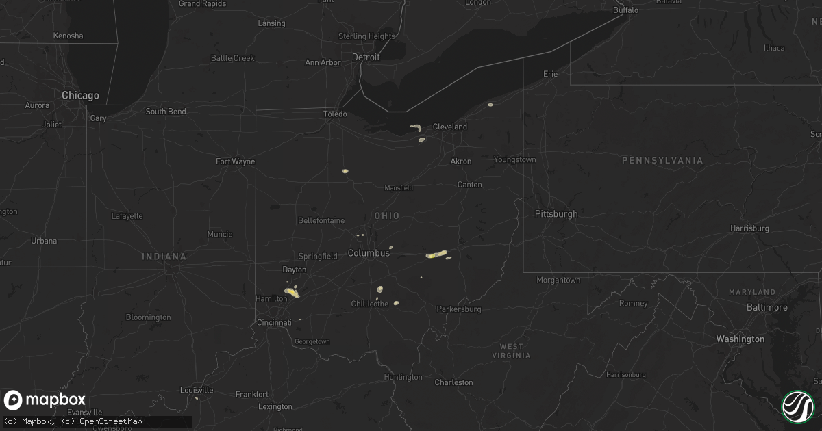
Hail Map in Ohio on August 21, 2022
Get this storm
August 21 map
$229
one time, instant access
Download today. No call, no setup
Keep the $229
Bought the map and want the full workflow? Apply the entire $229 to a subscription within 7 days. None of it is wasted.
Every map, not just this one
This buys you this map. Subscription and you get every map we run, in the markets you choose from a few cities to whole states to nationwide. Plus real-time alerts the moment a storm fires.
Contact data
Name, contact info, occupancy, even credit band for addresses in the footprint. You go from where it hit to who to call.
Become the source they trust
Unlimited branding weather history reports on demand. You already have the documented answer ready for the property owner, and you are the one who showed up with it.
Property data and RoofTrace estimates
Pull up any address you have got, its value and the exact code rules for that jurisdiction, straight from One Click Code. Then RoofTrace estimates the squares, pitch, and roof value, priced the way you price.
Storm reports in Ohio
Ohio
| Date | Description |
|---|---|
| 08/21/20225:45 PM CDT | Several large tree limbs down. |
| 08/21/20225:42 PM CDT | Wires down on us 42. Time estimated from radar. |
| 08/21/20225:04 PM CDT | Trees uprooted and siding from buildings ripped off. Possible tornado. Time estimated from radar. |
| 08/21/20224:13 PM CDT | Perry county 911 dispatch has a report of a fallen tree at monday creek township rd and township rd 186. Time estimated by radar. |
| 08/21/20223:55 PM CDT | Small branches down in willow creek subdivision. Photos posted on social media. Time estimated from radar. |
| 08/21/20222:22 PM CDT | Wires down on james road. Time estimated from radar. |
| 08/21/20222:10 PM CDT | Quarter sized hail in muskingum co. Time and location estimated by radar. |
| 08/21/202212:50 PM CDT | Trees and power poles down. Most of west jefferson without power. Time estimated from radar. |
| 08/21/202212:48 PM CDT | Numerous trees down in the area. Time estimated from radar. |
| 08/21/20221:23 AM CDT | At 623 PM EDT, a severe thunderstorm was located near Springboro, moving east at 20 mph. HAZARD...60 mph wind gusts and quarter size hail. SOURCE...Radar indicated. IMPACT...Minor hail damage to vehicles is possible. Expect wind damage to trees and power lines. Locations impacted include... Lebanon, Springboro, Franklin, Waynesville, Hunter, Clarksville, Harveysburg, Spring Valley, Corwin, Oregonia, Fort Ancient, Lytle, Mount Holly, Roxanna, Pekin, State Route 48 at State Route 73, Genntown, State Route 350 at US Route 22 and Caesar Creek State Park. |
| 08/21/202212:06 AM CDT | At 506 PM EDT, a severe thunderstorm was located 7 miles east of New Lexington, moving northeast at 25 mph. HAZARD...60 mph wind gusts and quarter size hail. SOURCE...Radar indicated. IMPACT...Hail damage to vehicles is expected. Expect wind damage to roofs, siding, and trees. Locations impacted include... New Lexington, Crooksville and Eagleport. |
| 08/21/202212:04 AM CDT | At 503 PM EDT, a severe thunderstorm was located 8 miles east of Kingston, moving northeast at 20 mph. HAZARD...60 mph wind gusts and quarter size hail. SOURCE...Radar indicated. IMPACT...Minor hail damage to vehicles is possible. Expect wind damage to trees and power lines. Locations impacted include... Lancaster, Logan, Hide-A-Way Hills, Amanda, Stoutsville, Laurelville, Sugar Grove, Adelphi, Tarlton, US Route 22 at State Route 159, Buena Vista in Hocking County, Gibisonville, Hideaway Hills, Lake Logan State Park, Whisler, Clearport, North Berne, Enterprise, Rockbridge and Hallsville. |
| 08/20/202210:34 PM CDT | At 333 PM EDT, a severe thunderstorm was located near Hocking Hills State Park, or 7 miles north of Mcarthur, moving northeast at 15 mph. HAZARD...60 mph wind gusts and quarter size hail. SOURCE...Radar indicated. IMPACT...Hail damage to vehicles is expected. Expect wind damage to roofs, siding, and trees. This severe thunderstorm will remain over mainly rural areas of north central Vinton and west central Athens Counties. |
| 08/20/202210:09 PM CDT | At 309 PM EDT, a severe thunderstorm was located near Granville South, moving northeast at 35 mph. HAZARD...60 mph wind gusts and quarter size hail. SOURCE...Radar indicated. IMPACT...Minor hail damage to vehicles is possible. Expect wind damage to trees and power lines. Locations impacted include... Newark, Heath, Granville, Pataskala, Johnstown, Buckeye Lake, Hebron, Utica, Hanover, Harbor Hills, Granville South, Marne, Beechwood Trails, Thornport, Etna, Jersey, Kirkersville, Alexandria, St. Louisville and Gratiot. |
| 08/20/202210:06 PM CDT | At 306 PM EDT, a severe thunderstorm was located over Zanesville, moving northeast at 15 mph. HAZARD...60 mph wind gusts and quarter size hail. SOURCE...Radar indicated. IMPACT...Minor hail damage to vehicles is possible. Expect wind damage to trees and power lines, resulting in some power outages. Locations impacted include... Zanesville, New Concord, South Zanesville, North Zanesville, Philo, Pleasant Grove, Norwich, Cannelville, Chandlersville, Bridgeville, Duncan Falls, and Drake. |
| 08/20/20229:12 PM CDT | At 212 PM EDT, a severe thunderstorm was located near Lake Darby, moving east at 25 mph. HAZARD...60 mph wind gusts and quarter size hail. SOURCE...Radar indicated. IMPACT...Minor hail damage to vehicles is possible. Expect wind damage to trees and power lines. Locations impacted include... Columbus, Grove City, Upper Arlington, Gahanna, Hilliard, Bexley, Groveport, Ohio State University, Easton, Lake Darby, Whitehall, Grandview Heights, Obetz, Urbancrest, Valleyview, Marble Cliff, Port Columbus Airport, Blacklick Estates, Georgesville and Lincoln Village. |
| 08/20/20228:48 PM CDT | At 148 PM EDT, a severe thunderstorm was located over West Jefferson, moving east at 25 mph. HAZARD...60 mph wind gusts. SOURCE...Radar indicated. IMPACT...Expect damage to trees and power lines. Locations impacted include... Columbus, Grove City, Hilliard, Jefferson, West Jefferson, Lake Darby, Georgesville, Lincoln Village and New Rome. |
| 08/20/20228:45 PM CDT | At 145 PM EDT, a severe thunderstorm was located near Xenia, moving east at 25 mph. HAZARD...60 mph wind gusts and quarter size hail. SOURCE...Radar indicated. IMPACT...Minor hail damage to vehicles is possible. Expect wind damage to trees and power lines. Locations impacted include... Xenia, Jamestown, New Jasper, Spring Valley, Bowersville, Paintersville, Rosemoor, Gladstone, Middleton Corner and Bell Center. |
| 08/20/20228:39 PM CDT | At 139 PM EDT, a severe thunderstorm was located near Powell, moving east at 20 mph. HAZARD...60 mph wind gusts and quarter size hail. SOURCE...Radar indicated. IMPACT...Minor hail damage to vehicles is possible. Expect wind damage to trees and power lines. Locations impacted include... Columbus, Dublin, Westerville, Delaware, Powell, Sunbury, Polaris, Shawnee Hills, Galena, Ostrander, Hartford, Interstate 71 at US Route 36/State Route 37, Alum Creek State Park, Olive Green, Stratford, Bellepoint, Center Village, Kilbourne, Columbus Zoo and Lewis Center. |
All States Impacted by Hail Map on August 21, 2022
Cities Impacted by Hail Map on August 21, 2022
- Blackfoot, ID
- Soda Springs, ID
- Overton, NV
- Elyria, OH
- Kalispell, MT
- Batavia, OH
- Arnoldsburg, WV
- Spencer, WV
- Oregonia, OH
- Lebanon, OH
- Franklin, OH
- Middletown, OH
- Springboro, OH
- Centertown, KY
- Alton, UT
- Glendale, UT
- Orderville, UT
- Memphis, TN
- Millington, TN
- Kanab, UT
- Cromwell, KY
- Horse Branch, KY
- Caneyville, KY
- Waynesville, OH
- New Lexington, OH
- Pataskala, OH
- Granville, OH
- Miamisburg, OH
- Dolan Springs, AZ
- Carey, OH
- Caliente, NV
- Peach Springs, AZ
- Kingman, AZ
- Hackberry, AZ
- Elizabethtown, NC
- Garland, NC
- Willow Beach, AZ
- Meadview, AZ
- Chloride, AZ
- Golden Valley, AZ
- Bullhead City, AZ
- Tropic, UT
- Henrieville, UT
- Escalante, UT
- Hurricane, UT
- Clarendon, NC
- Tabor City, NC
- Masontown, WV
- Bluffton, SC
- Osceola, AR
- Henning, TN
- Burlison, TN
- Wilson, AR
- Drummonds, TN
- Williams, AZ
- Maple Hill, NC
- Madison, OH
- Geneva, OH
- Vandergrift, PA
- Leechburg, PA
- Saint George, UT
- Memphis, NY
- Beryl, UT
- Enterprise, UT
- New Concord, OH
- Zanesville, OH
- Chandlersville, OH
- Norwich, OH
- Powell, OH
- Plain City, OH
- Delaware, OH
- Littlefield, AZ
- Ocala, FL
- Summer Shade, KY
- Tompkinsville, KY
- Vevay, IN
- Kamas, UT
- American Falls, ID
- Deep Run, NC
- Supai, AZ
- Congress, AZ
- Wickenburg, AZ
- Sedona, AZ
- Micanopy, FL
- Reddick, FL
- Williston, FL
- Jacksonville, FL
- Saint Johns, FL
- Morgantown, KY
- Lane, SC
- Andrews, SC
- Lake Havasu City, AZ
- Humboldt, AZ
- Dewey, AZ
- Young, AZ
- Rockland, ID
- Louisville, KY
- Penn Run, PA
- Lorain, OH
- Cumberland, OH
- Colorado City, AZ
- Okatie, SC
- Mayer, AZ
- Glasgow, KY
- Pocatello, ID
- Arbon, ID
- South Bloomingville, OH
- Creola, OH
- McArthur, OH
- Payson, AZ
- Arlington, TN
- Atoka, TN
- Prescott, AZ
- Ash Fork, AZ
- Seligman, AZ
- Parker, AZ
- Circleville, OH
- Kingston, OH
- Laurelville, OH
- Tampa, FL
- Chillicothe, OH
- Yemassee, SC
- Cottonwood, AZ
- Cornville, AZ
- Salome, AZ
- Hardeeville, SC
- Savannah, GA
- Bradenton, FL
- Sarasota, FL
- Wolfe City, TX
- East Syracuse, NY
- Syracuse, NY
- Cicero, NY
- Bridgeport, NY


