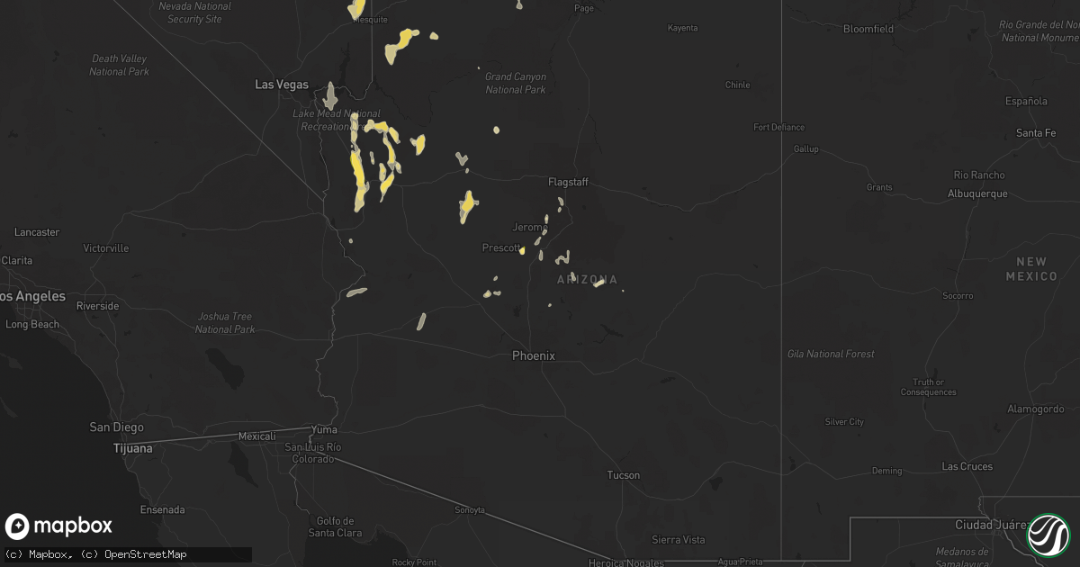
Hail Map in Arizona on August 21, 2022
Get this storm
August 21 map
$229
one time, instant access
Download today. No call, no setup
Keep the $229
Bought the map and want the full workflow? Apply the entire $229 to a subscription within 7 days. None of it is wasted.
Every map, not just this one
This buys you this map. Subscription and you get every map we run, in the markets you choose from a few cities to whole states to nationwide. Plus real-time alerts the moment a storm fires.
Contact data
Name, contact info, occupancy, even credit band for addresses in the footprint. You go from where it hit to who to call.
Become the source they trust
Unlimited branding weather history reports on demand. You already have the documented answer ready for the property owner, and you are the one who showed up with it.
Property data and RoofTrace estimates
Pull up any address you have got, its value and the exact code rules for that jurisdiction, straight from One Click Code. Then RoofTrace estimates the squares, pitch, and roof value, priced the way you price.
Storm reports in Arizona
Arizona
| Date | Description |
|---|---|
| 08/21/20227:35 AM CDT | At 1234 PM MST, a severe thunderstorm was located 17 miles northeast of Bagdad moving west at 10 mph. HAZARD...Quarter size hail. SOURCE...Radar indicated. IMPACT...Damage to vehicles is expected. This severe thunderstorm will remain over mainly rural areas of Yavapai County. |
| 08/21/20226:57 AM CDT | At 1157 PM MST/1157 PM PDT/, severe thunderstorms were located along a line extending from 8 miles west of Midland to 7 miles west of Nicholls Warm Springs to Ripley to 19 miles west of Kofa Wildlife Refuge, moving southwest at 30 mph. HAZARD...60 mph wind gusts. SOURCE...Radar indicated. IMPACT...Expect damage to roofs, siding, and trees. Locations impacted include... Blythe, Quartzsite, Nicholls Warm Springs, Cibola, Palo Verde, Midland, Blythe Airport, Ripley, East Blythe and Ehrenberg.This includes the following highways...AZ Interstate 10 between mile markers 1 and 17.CA Interstate 10 between mile markers 113 and 156.AZ Route 95 between mile markers 84 and 103. |
| 08/21/20224:37 AM CDT | At 937 PM MST, a severe thunderstorm was located 7 miles northwest of Gu Vo, or 21 miles southeast of Ajo, moving south at 20 mph. HAZARD...60 mph wind gusts and penny size hail. SOURCE...Radar indicated. IMPACT...Expect damage to roofs, siding, and trees. Locations impacted include... Gu Vo, Organ Pipe Cactus National Monument, Ali Chugk, Pia Oik, Lukeville and Kuakatch. |
| 08/21/20223:56 AM CDT | At 856 PM MST, severe thunderstorms were located along a line extending from 11 miles north of Ajo to near Kaka, moving south at 25 mph. HAZARD...60 mph wind gusts and penny size hail. SOURCE...Radar indicated. IMPACT...Expect damage to roofs, siding, and trees. Locations impacted include... Ajo, Hickiwan, San Simon, Why, Charco 27, Ventana, Gunsight, Vaya Chin and San Simon West. |
| 08/21/20223:46 AM CDT | At 846 PM MST, a severe thunderstorm was located over Gu Vo, or 25 miles southeast of Ajo, moving southwest at 15 mph. HAZARD...60 mph wind gusts and penny size hail. SOURCE...Radar indicated. IMPACT...Expect damage to roofs, siding, and trees. Locations impacted include... Gu Vo, Organ Pipe Cactus National Monument, Ali Chugk, Pia Oik, Lukeville and Kuakatch. |
| 08/21/20223:34 AM CDT | At 833 PM MST, a severe thunderstorm was located 7 miles southeast of Wenden, or 34 miles northwest of Tonopah, moving south at 15 mph. HAZARD...60 mph wind gusts and quarter size hail. SOURCE...Radar indicated. IMPACT...Hail damage to vehicles is expected. Expect wind damage to roofs, siding, and trees. Locations impacted include... Wenden and Salome. This includes the following highways...AZ Interstate 10 between mile markers 49 and 71.US Highway 60 between mile markers 55 and 72. |
| 08/21/20223:08 AM CDT | ***delayed report*** shed blown into power line taking a pole down with it. Timing estimated from radar. |
| 08/21/20223:07 AM CDT | ***delayed report*** peak wind reported. |
| 08/21/20223:03 AM CDT | ***delayed report*** peak wind reported. |
| 08/21/20222:54 AM CDT | ***delayed report*** peak wind reported. |
| 08/21/20222:50 AM CDT | At 749 PM MST, a severe thunderstorm was located near Santa Rosa, or 34 miles north of Sells, moving south at 15 mph. HAZARD...60 mph wind gusts and penny size hail. SOURCE...Radar indicated. IMPACT...Expect damage to roofs, siding, and trees. Locations impacted include... Santa Rosa, Covered Wells, Anegam, San Simon, Palo Verde Stand, Ventana, Ak Chin, No:ligk, Vaya Chin, Cababi, San Luis - Sells District, Mountain Village, San Luis, Rincon, Santa Rosa School and San Simon West. |
| 08/21/20222:44 AM CDT | At 744 PM MST, a severe thunderstorm was located 8 miles east of Freeman, or 24 miles west of Casa Grande, moving south at 10 mph. HAZARD...60 mph wind gusts. SOURCE...Radar indicated. IMPACT...Expect damage to roofs, siding, and trees. This severe thunderstorm will remain over mainly rural areas of Maricopa and Pinal Counties.This includes AZ Interstate 8 between mile markers 143 and 157. |
| 08/21/20222:25 AM CDT | At 725 PM MST, a severe thunderstorm was located 10 miles southeast of Alamo State Park, or 11 miles southeast of Alamo Lake, moving south at 5 mph. HAZARD...60 mph wind gusts and quarter size hail. SOURCE...Radar indicated. IMPACT...Hail damage to vehicles is expected. Expect wind damage to roofs, siding, and trees. This severe thunderstorm will remain over mainly rural areas of northeastern La Paz County. |
| 08/21/20222:02 AM CDT | At 701 PM MST, a severe thunderstorm was located near San Tan Mountain Park, or 12 miles northwest of Coolidge, moving south at 10 mph. HAZARD...60 mph wind gusts and penny size hail. SOURCE...Radar indicated. IMPACT...Expect damage to roofs, siding, and trees. Locations impacted include... Chandler, Casa Grande, Coolidge, Queen Creek, Blackwater, Chandler Heights, San Tan Mountain Park, San Tan Valley, Seville, Sacaton and Santan.This includes the following highways...AZ Interstate 10 between mile markers 177 and 190.AZ Route 87 between mile markers 132 and 157. |
| 08/21/20221:53 AM CDT | At 653 PM MST, a severe thunderstorm was located 8 miles northeast of Wickenburg, moving southwest at 10 mph. HAZARD...60 mph wind gusts. SOURCE...Radar indicated. IMPACT...Expect damage to roofs, siding, and trees. Locations impacted include... Wickenburg, Wittmann, Circle City and Morristown. This includes the following highways...US Highway 60 between mile markers 96 and 131.AZ Route 74 between mile markers 1 and 7. |
| 08/21/20221:52 AM CDT | At 651 PM PDT/651 PM MST/, a severe thunderstorm was located 11 miles west of Temple Bar Campground, or 18 miles east of Boulder City, moving south at 20 mph. HAZARD...70 mph wind gusts. SOURCE...Radar indicated. IMPACT...Expect considerable tree damage. Damage is likely to mobile homes, roofs, and outbuildings. Locations impacted include... Henderson, North Las Vegas, Boulder City, Nellis AFB, The Motor Speedway, Las Vegas Bay, Lake Las Vegas, East Las Vegas, Echo Bay, Grand Canyon Skywalk, Diamond Creek Campground, Railroad Pass, Boulder Beach Campground, Las Vegas Bay Campground, Pierce Ferry And Antares Roads, Meadview, Hoover Dam, Temple Bar Campground, South Cove and Boulder Beach.This includes Interstate 15 in Nevada between mile markers 60 and 74. |
| 08/21/20221:45 AM CDT | At 644 PM MST, a severe thunderstorm was located 8 miles northeast of Wickenburg, moving southwest at 15 mph. HAZARD...60 mph wind gusts, penny size hail, and heavy rainfall. SOURCE...Radar indicated. IMPACT...Expect damage to roofs, siding, and trees. This severe thunderstorm will remain over mainly rural areas of Yavapai County. |
| 08/21/20221:38 AM CDT | At 638 PM MST, a severe thunderstorm was located 10 miles northeast of Christmas, moving southwest at 5 mph. HAZARD...60 mph wind gusts and quarter size hail. SOURCE...Radar indicated. IMPACT...Hail damage to vehicles is expected. Expect wind damage to roofs, siding, and trees. Locations impacted include... Hayden and Christmas. This includes the following highways...AZ Route 77 between mile markers 135 and 141, near mile marker 143,and between mile markers 146 and 161.AZ Route 177 between mile markers 137 and 138. |
| 08/21/20221:07 AM CDT | At 607 PM MST, severe thunderstorms were located along a line extending from Paradise Valley to Granite Reef Dam, moving south at 30 mph. HAZARD...60 mph wind gusts. SOURCE...Radar indicated. IMPACT...Expect damage to roofs, siding, and trees. Locations impacted include... Phoenix, Mesa, Chandler, Scottsdale, Gilbert, Tempe, Apache Junction, Paradise Valley, Laveen, East Mesa, Sun Lakes, Queen Creek, Tempe Marketplace, Piestewa Peak Park and Salt River Indian Community.This includes the following highways...AZ Interstate 10 between mile markers 140 and 175.AZ Interstate 17 between mile markers 195 and 206.AZ Route 51 between mile markers 1 and 8. |
| 08/21/202212:56 AM CDT | At 555 PM PDT/555 PM MST/, a severe thunderstorm was located near Las Vegas Bay Campground, or near The Motor Speedway, moving south at 20 mph. HAZARD...60 mph wind gusts. SOURCE...Radar indicated. IMPACT...Expect damage to roofs and trees. Locations impacted include... Henderson, North Las Vegas, Mesquite, Boulder City, Nellis AFB, The Motor Speedway, Las Vegas Bay, Lake Las Vegas, Overton, Moapa Town, East Las Vegas, Moapa Valley, Echo Bay, Grand Canyon Skywalk, Sr 168 Mile Marker 21, Boulder Beach Campground, Las Vegas Bay Campground, Meadview, Hoover Dam and Bunkerville.This includes Interstate 15 in Nevada between mile markers 60 and116. |
| 08/21/202212:45 AM CDT | At 545 PM MST, severe thunderstorms were located along a line extending from near Scottsdale to near Rio Verde, moving southeast at 15 mph. HAZARD...60 mph wind gusts. SOURCE...Radar indicated. IMPACT...Expect damage to roofs, siding, and trees. Locations impacted include... Phoenix, Mesa, Scottsdale, Apache Junction, Fountain Hills, Paradise Valley, Sugarloaf Mountain, Carefree, Piestewa Peak Park, Granite Reef Dam, Falcon Field Airport, Salt River Indian Community, Lost Dutchman State Park, North Mountain Park and Goldfield.This includes the following highways...AZ Route 51 between mile markers 4 and 15.AZ Route 87 between mile markers 174 and 208.AZ Route 202 between mile markers 11 and 27. |
| 08/21/202212:40 AM CDT | At 540 PM MST, a severe thunderstorm was located near San Carlos, or 18 miles southeast of Globe, and is nearly stationary. HAZARD...60 mph wind gusts and quarter size hail. SOURCE...Radar indicated. IMPACT...Hail damage to vehicles is expected. Expect wind damage to roofs, siding, and trees. Locations impacted include... San Carlos Reservoir. |
| 08/21/202212:34 AM CDT | At 534 PM MST, a severe thunderstorm was located near San Carlos, or 19 miles southeast of Globe, and is nearly stationary. HAZARD...60 mph wind gusts and quarter size hail. SOURCE...Radar indicated. IMPACT...Hail damage to vehicles is expected. Expect wind damage to roofs, siding, and trees. Locations impacted include... San Carlos and Cutter. This includes AZ Route 70 between mile markers 258 and 271. |
| 08/21/202212:29 AM CDT | At 528 PM MST, a severe thunderstorm was located 7 miles northeast of New River, and is nearly stationary. HAZARD...60 mph wind gusts. SOURCE...Radar indicated. IMPACT...Expect damage to roofs, siding, and trees. Locations impacted include... Scottsdale, New River, Cave Creek, Carefree, Lake Pleasant, Desert Mountain and Anthem.This includes the following highways...AZ Interstate 17 between mile markers 220 and 241.AZ Route 74 between mile markers 16 and 30.AZ Route 303 between mile markers 129 and 139. |
| 08/21/202212:10 AM CDT | At 508 PM MST, a severe thunderstorm was located 11 miles north of Jacob Lake, or 18 miles southeast of Kanab, moving south at 20 mph. HAZARD...60 mph wind gusts and quarter size hail. SOURCE...Radar indicated. IMPACT...Hail damage to vehicles is expected. Expect wind damage to roofs, siding, and trees. This severe thunderstorm will impact Hwy 89a between Fredonia and Jacob Lake. |
| 08/21/202212:06 AM CDT | The aprswxnet/cwop site in yucca... Az gusted to 60 mph at 1013pm. Also gusted to 59 mph at 1006pm. |
| 08/21/202212:00 AM CDT | At 458 PM PDT/458 PM MST/, a severe thunderstorm was located 10 miles west of Bunkerville, or 10 miles west of Mesquite, moving south at 30 mph. Another severe thunderstorm was located 15 miles east southeast of Mesquite moving south at 20 mph. HAZARD...60 mph wind gusts and quarter size hail. SOURCE...Radar indicated. IMPACT...Hail damage to vehicles is expected. Expect wind damage to roofs and trees. Locations impacted include... Mesquite, Virgin River Gorge, Overton, Beaver Dam, Littlefield, Moapa Town, Moapa Valley, Echo Bay, Echo Bay Campground, Bunkerville, Virgin River Campground, Valley Of Fire, Overton Beach, Logandale and Carp.This includes the following highways... Interstate 15 in Arizona between mile markers 0 and 23. Interstate 15 in Nevada between mile markers 80 and 120. |
| 08/20/202211:48 PM CDT | At 448 PM MST, a severe thunderstorm was located near Camp Creek, or 16 miles east of New River, and is nearly stationary. HAZARD...60 mph wind gusts. SOURCE...Radar indicated. IMPACT...Expect damage to roofs, siding, and trees. Locations impacted include... Scottsdale, New River, Cave Creek, Carefree, Desert Mountain, Camp Creek, Anthem and Seven Springs.This includes AZ Interstate 17 between mile markers 225 and 227. |
| 08/20/202211:43 PM CDT | At 442 PM MST, a severe thunderstorm was located near Horseshoe Reservoir, or 11 miles northwest of Sycamore Creek, moving south at 5 mph. HAZARD...60 mph wind gusts. SOURCE...Radar indicated. IMPACT...Expect damage to roofs, siding, and trees. Locations impacted include... Round Valley, Ballantine Trailhead, Sycamore Creek, Sunflower, Desert Mountain, Camp Creek and Horseshoe Reservoir.This includes AZ Route 87 between mile markers 210 and 223. |
| 08/20/202211:41 PM CDT | At 440 PM MST, a severe thunderstorm was located near Dewey- Humboldt, or 11 miles southeast of Prescott Valley, moving south at 10 mph. HAZARD...60 mph wind gusts, quarter size hail, and heavy rainfall. SOURCE...Radar indicated. IMPACT...Hail damage to vehicles is expected. Expect wind damage to roofs, siding, and trees. Locations impacted include... Dewey-Humboldt, Mayer and Poland Junction. |
| 08/20/202211:27 PM CDT | At 426 PM MST, a severe thunderstorm was located 21 miles west of Paulden, or 24 miles northwest of Chino Valley, moving south at 10 to 15 mph. HAZARD...Up to 60 mph wind gusts, quarter size hail, and heavy rainfall. SOURCE...Radar indicated. IMPACT...Hail damage to vehicles is expected. Expect wind damage to roofs, siding, and trees. Locations impacted include... Walnut Creek Ranger Station. |
| 08/20/202211:05 PM CDT | At 403 PM PDT, a severe thunderstorm was located 17 miles west of Gunlock State Park, or 19 miles north of Beaver Dam, moving south at 25 mph. HAZARD...60 mph wind gusts and quarter size hail. SOURCE...Radar indicated. IMPACT...Hail damage to vehicles is expected. Expect wind damage to roofs and trees. Locations impacted include... Mesquite, Bunkerville, Elgin and Carp. This includes Interstate 15 in Nevada between mile markers 110 and120. |
| 08/20/202210:56 PM CDT | At 355 PM MST, a severe thunderstorm was located near Star Valley, or 7 miles southeast of Payson, moving south at 5 to 10 mph. HAZARD...Up to 50 mph wind gusts, quarter size hail, and heavy rainfall. SOURCE...Radar indicated. IMPACT...Hail damage to vehicles is expected. Expect wind damage to roofs, siding, and trees. Locations impacted include... Payson, Round Valley, Gisela, Rye and Deer Creek. |
| 08/20/202210:50 PM CDT | At 349 PM MST, a severe thunderstorm was located over Cherry, or 8 miles west of Camp Verde, moving south at 5 mph. HAZARD...Up to 50 mph wind gusts, quarter size hail, and heavy rainfall. SOURCE...Radar indicated. IMPACT...Hail damage to vehicles is expected. Expect wind damage to roofs, siding, and trees. Locations impacted include... Camp Verde, Cherry and Powell Springs Campground. |
| 08/20/202210:25 PM CDT | Arizona department of transportation reported a semi truck had been blown over on highway 93 by mile marker 14 in arizona. |
| 08/20/20228:11 PM CDT | ***delayed report*** large tree fell in between two cars due to strong winds. |
| 08/20/20227:48 PM CDT | Humbug creek raws reports 36 mph wind with 71 mph gust. |
All States Impacted by Hail Map on August 21, 2022
Cities Impacted by Hail Map on August 21, 2022
- Blackfoot, ID
- Soda Springs, ID
- Overton, NV
- Elyria, OH
- Kalispell, MT
- Batavia, OH
- Arnoldsburg, WV
- Spencer, WV
- Oregonia, OH
- Lebanon, OH
- Franklin, OH
- Middletown, OH
- Springboro, OH
- Centertown, KY
- Alton, UT
- Glendale, UT
- Orderville, UT
- Memphis, TN
- Millington, TN
- Kanab, UT
- Cromwell, KY
- Horse Branch, KY
- Caneyville, KY
- Waynesville, OH
- New Lexington, OH
- Pataskala, OH
- Granville, OH
- Miamisburg, OH
- Dolan Springs, AZ
- Carey, OH
- Caliente, NV
- Peach Springs, AZ
- Kingman, AZ
- Hackberry, AZ
- Elizabethtown, NC
- Garland, NC
- Willow Beach, AZ
- Meadview, AZ
- Chloride, AZ
- Golden Valley, AZ
- Bullhead City, AZ
- Tropic, UT
- Henrieville, UT
- Escalante, UT
- Hurricane, UT
- Clarendon, NC
- Tabor City, NC
- Masontown, WV
- Bluffton, SC
- Osceola, AR
- Henning, TN
- Burlison, TN
- Wilson, AR
- Drummonds, TN
- Williams, AZ
- Maple Hill, NC
- Madison, OH
- Geneva, OH
- Vandergrift, PA
- Leechburg, PA
- Saint George, UT
- Memphis, NY
- Beryl, UT
- Enterprise, UT
- New Concord, OH
- Zanesville, OH
- Chandlersville, OH
- Norwich, OH
- Powell, OH
- Plain City, OH
- Delaware, OH
- Littlefield, AZ
- Ocala, FL
- Summer Shade, KY
- Tompkinsville, KY
- Vevay, IN
- Kamas, UT
- American Falls, ID
- Deep Run, NC
- Supai, AZ
- Congress, AZ
- Wickenburg, AZ
- Sedona, AZ
- Micanopy, FL
- Reddick, FL
- Williston, FL
- Jacksonville, FL
- Saint Johns, FL
- Morgantown, KY
- Lane, SC
- Andrews, SC
- Lake Havasu City, AZ
- Humboldt, AZ
- Dewey, AZ
- Young, AZ
- Rockland, ID
- Louisville, KY
- Penn Run, PA
- Lorain, OH
- Cumberland, OH
- Colorado City, AZ
- Okatie, SC
- Mayer, AZ
- Glasgow, KY
- Pocatello, ID
- Arbon, ID
- South Bloomingville, OH
- Creola, OH
- McArthur, OH
- Payson, AZ
- Arlington, TN
- Atoka, TN
- Prescott, AZ
- Ash Fork, AZ
- Seligman, AZ
- Parker, AZ
- Circleville, OH
- Kingston, OH
- Laurelville, OH
- Tampa, FL
- Chillicothe, OH
- Yemassee, SC
- Cottonwood, AZ
- Cornville, AZ
- Salome, AZ
- Hardeeville, SC
- Savannah, GA
- Bradenton, FL
- Sarasota, FL
- Wolfe City, TX
- East Syracuse, NY
- Syracuse, NY
- Cicero, NY
- Bridgeport, NY


