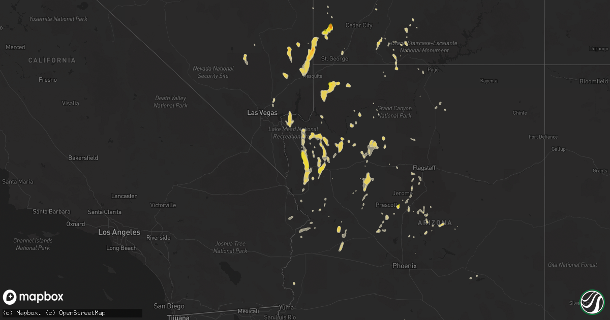
Hail Map on August 21, 2022
Get this storm
August 21 map
$229
one time, instant access
Download today. No call, no setup
Keep the $229
Bought the map and want the full workflow? Apply the entire $229 to a subscription within 7 days. None of it is wasted.
Every map, not just this one
This buys you this map. Subscription and you get every map we run, in the markets you choose from a few cities to whole states to nationwide. Plus real-time alerts the moment a storm fires.
Contact data
Name, contact info, occupancy, even credit band for addresses in the footprint. You go from where it hit to who to call.
Become the source they trust
Unlimited branding weather history reports on demand. You already have the documented answer ready for the property owner, and you are the one who showed up with it.
Property data and RoofTrace estimates
Pull up any address you have got, its value and the exact code rules for that jurisdiction, straight from One Click Code. Then RoofTrace estimates the squares, pitch, and roof value, priced the way you price.
States Impacted by Hail Map on August 21, 2022
Storm reports
Mississippi
| Date | Description |
|---|---|
| 08/21/202212:15 PM CDT | Barn destroyed by possible straight line winds. |
| 08/21/20226:24 AM CDT | At 1123 AM CDT, a severe thunderstorm was located over Byhalia, or 10 miles southeast of Olive Branch, moving southeast at 25 mph. HAZARD...60 mph wind gusts. SOURCE...Radar indicated. IMPACT...Expect damage to roofs, siding, and trees. Locations impacted include... Holly Springs, Byhalia, Red Banks, Marianna, Coal Oil Corner, Victoria, Higdon, Watson, Gilton, Taska, Atway, Mack, Mahon and Handy Corner. |
Pennsylvania
| Date | Description |
|---|---|
| 08/20/20228:27 PM CDT | At 125 PM EDT, a severe thunderstorm was located near Beech Creek, moving northeast at 25 mph. HAZARD...60 mph wind gusts and penny size hail. SOURCE...Radar indicated. IMPACT...Expect damage to roofs, siding, and trees. Locations impacted include... Lock Haven, Jersey Shore, Mill Hall, Avis, Dunnstown, Flemington, Castanea, Blanchard, McElhattan, Monument, Mackeyville and Waterville.For those driving on Interstate 80, this includes areas between theBellefonte and Loganton exits, specifically from mile markers 169 to182. |
West Virginia
| Date | Description |
|---|---|
| 08/20/202211:15 PM CDT | At 415 AM EDT, a severe thunderstorm was located over Gauley Bridge, or 11 miles northwest of Fayetteville, moving northeast at 25 mph. HAZARD...60 mph wind gusts. SOURCE...Radar indicated. IMPACT...Expect damage to roofs, siding, and trees. Locations impacted include... Ansted, Gauley Bridge, Hawks Nest State Park, Bentree, Swiss and Drennan. |
| 08/20/202210:47 PM CDT | At 347 AM EDT, a severe thunderstorm was located near Kenna, or 11 miles northeast of Winfield, moving northeast at 30 mph. HAZARD...60 mph wind gusts. SOURCE...Radar indicated. IMPACT...Expect damage to roofs, siding, and trees. Locations impacted include... Sissonville, Kenna, Statts Mills, Harmony, Kentuck, Liberty, Fairplain and Gay.This includes Interstate 77 in West Virginia between mile markers 114and 133. |
Virginia
| Date | Description |
|---|---|
| 08/21/202210:20 AM CDT | Several trees and large tree limbs blew down across va-795 blenheim road from the 7000 block to the 7600 block. A few blocked the roadway and adjacent driveways. Trees |
Idaho
| Date | Description |
|---|---|
| 08/21/20222:08 AM CDT | At 708 PM MDT, a severe thunderstorm was located near Rockland, or 16 miles south of Neeley, moving southeast at 10 mph. HAZARD...60 mph wind gusts and quarter size hail. SOURCE...Radar indicated. IMPACT...Hail damage to vehicles is expected. Expect wind damage to roofs, siding, and trees. Locations impacted include... Rockland and Roy. |
| 08/21/202212:59 AM CDT | At 558 PM MDT, a severe thunderstorm was located 8 miles north of Rose, or 12 miles north of Blackfoot, and is nearly stationary. HAZARD...60 mph wind gusts and quarter size hail. SOURCE...Radar indicated. IMPACT...Hail damage to vehicles is expected. Expect wind damage to roofs, siding, and trees. Locations impacted include... Shelley, Firth, Rose, Basalt and Wapello. |
South Carolina
| Date | Description |
|---|---|
| 08/21/20223:40 PM CDT | A 911 call center reported a tree down along pinckney colony blvd blocking the roadway. |
| 08/20/202211:45 PM CDT | At 445 PM EDT, a severe thunderstorm was located near Hutchinson Island, moving east at 10 mph. HAZARD...60 mph wind gusts and nickel size hail. SOURCE...Radar indicated. IMPACT...Expect damage to trees and powerlines. Locations impacted include: Hilton Head Island, Bluffton, Tybee Island, Wilmington Island, Fort Pulaski National Monument, Midtown Savannah, Downtown Savannah, Thunderbolt, Sandfly, Savannah Historic District, Isle Of Hope, Whitemarsh Island, Forest Beach, Hutchinson Island and Skidaway Island. |
| 08/20/202211:32 PM CDT | At 432 PM EDT, a severe thunderstorm was located over Pritchardville, moving northeast at 5 mph. HAZARD...60 mph wind gusts and quarter size hail. SOURCE...Radar indicated. IMPACT...Minor hail damage to vehicles is possible. Expect wind damage to trees and powerlines. Locations impacted include: Hilton Head Island, Bluffton, Bellinger Hill Area, Jasper, Hardeeville, Calawassie Island, Pritchardville, Rose Hill and Sun City.This warning includes I-95 in South Carolina between mile markers 6and 12. |
Kentucky
| Date | Description |
|---|---|
| 08/21/20222:37 PM CDT | Wrn ambassador sent pictures of large tree limbs broken on highway 76 in the community of eli. Barn roof metal was also peeled back... But not blown away. Time estimate |
| 08/21/20227:49 AM CDT | At 1249 PM EDT, a severe thunderstorm was located over Lebanon, moving southeast at 40 mph. HAZARD...60 mph wind gusts. SOURCE...Radar indicated. IMPACT...Expect damage to roofs, siding, and trees. This severe thunderstorm will remain over mainly rural areas of southeastern Marion, northeastern Taylor, southwestern Boyle and northwestern Casey Counties, including the following locations... Calvary, Bradfordsville, Greenbriar, Gravel Switch, Forkland, Phillipsburg, Salleetown, Jacktown, Riley and Poplar Corner. |
| 08/20/202210:29 PM CDT | At 329 PM CDT, a severe thunderstorm was located 7 miles west of Cabell, moving southeast at 25 mph. HAZARD...60 mph wind gusts and quarter size hail. SOURCE...Radar indicated. IMPACT...Hail damage to vehicles is expected. Expect wind damage to roofs, siding, and trees. This severe thunderstorm will remain over mainly rural areas of central Clinton and south central Russell Counties, including the following locations... Aaron, Cartwright, Cumberland City, Nora, Marlow, Alpha, Narvel and Seventy Six. |
Florida
| Date | Description |
|---|---|
| 08/21/20224:50 PM CDT | Report of tree down due to thunderstorm winds. |
| 08/21/20224:35 PM CDT | Fdem relayed reports of damage to around a dozen manufactured homes consisting mostly of metal pieces being peeled away from roofs and sides of structures. Downburst si |
| 08/21/20224:32 PM CDT | Broadcast media relayed photos on social media of multiple trees down along walnut bend rd. Time estimate based on radar. |
| 08/21/202212:29 AM CDT | At 529 PM EDT, a severe thunderstorm was located over Fruit Cove, moving southwest at 10 mph. HAZARD...60 mph wind gusts and quarter size hail. SOURCE...Radar indicated. IMPACT...Hail damage to vehicles is expected. Expect wind damage to roofs, siding, and trees. Locations impacted include... Fruit Cove, Mandarin and Switzerland. |
| 08/20/202210:27 PM CDT | At 327 PM EDT, a severe thunderstorm was located over Ocala, moving south at 5 mph. HAZARD...60 mph wind gusts and quarter size hail. SOURCE...Radar indicated. IMPACT...Hail damage to vehicles is expected. Expect wind damage to roofs, siding, and trees. Locations impacted include... Ocala, Santos, Ocala Airport, Lake Weir, Silver Springs Shores, Belleview and Summerfield. |
Ohio
| Date | Description |
|---|---|
| 08/21/20225:45 PM CDT | Several large tree limbs down. |
| 08/21/20225:42 PM CDT | Wires down on us 42. Time estimated from radar. |
| 08/21/20225:04 PM CDT | Trees uprooted and siding from buildings ripped off. Possible tornado. Time estimated from radar. |
| 08/21/20224:13 PM CDT | Perry county 911 dispatch has a report of a fallen tree at monday creek township rd and township rd 186. Time estimated by radar. |
| 08/21/20223:55 PM CDT | Small branches down in willow creek subdivision. Photos posted on social media. Time estimated from radar. |
| 08/21/20222:22 PM CDT | Wires down on james road. Time estimated from radar. |
| 08/21/20222:10 PM CDT | Quarter sized hail in muskingum co. Time and location estimated by radar. |
| 08/21/202212:50 PM CDT | Trees and power poles down. Most of west jefferson without power. Time estimated from radar. |
| 08/21/202212:48 PM CDT | Numerous trees down in the area. Time estimated from radar. |
| 08/21/20221:23 AM CDT | At 623 PM EDT, a severe thunderstorm was located near Springboro, moving east at 20 mph. HAZARD...60 mph wind gusts and quarter size hail. SOURCE...Radar indicated. IMPACT...Minor hail damage to vehicles is possible. Expect wind damage to trees and power lines. Locations impacted include... Lebanon, Springboro, Franklin, Waynesville, Hunter, Clarksville, Harveysburg, Spring Valley, Corwin, Oregonia, Fort Ancient, Lytle, Mount Holly, Roxanna, Pekin, State Route 48 at State Route 73, Genntown, State Route 350 at US Route 22 and Caesar Creek State Park. |
| 08/21/202212:06 AM CDT | At 506 PM EDT, a severe thunderstorm was located 7 miles east of New Lexington, moving northeast at 25 mph. HAZARD...60 mph wind gusts and quarter size hail. SOURCE...Radar indicated. IMPACT...Hail damage to vehicles is expected. Expect wind damage to roofs, siding, and trees. Locations impacted include... New Lexington, Crooksville and Eagleport. |
| 08/21/202212:04 AM CDT | At 503 PM EDT, a severe thunderstorm was located 8 miles east of Kingston, moving northeast at 20 mph. HAZARD...60 mph wind gusts and quarter size hail. SOURCE...Radar indicated. IMPACT...Minor hail damage to vehicles is possible. Expect wind damage to trees and power lines. Locations impacted include... Lancaster, Logan, Hide-A-Way Hills, Amanda, Stoutsville, Laurelville, Sugar Grove, Adelphi, Tarlton, US Route 22 at State Route 159, Buena Vista in Hocking County, Gibisonville, Hideaway Hills, Lake Logan State Park, Whisler, Clearport, North Berne, Enterprise, Rockbridge and Hallsville. |
| 08/20/202210:34 PM CDT | At 333 PM EDT, a severe thunderstorm was located near Hocking Hills State Park, or 7 miles north of Mcarthur, moving northeast at 15 mph. HAZARD...60 mph wind gusts and quarter size hail. SOURCE...Radar indicated. IMPACT...Hail damage to vehicles is expected. Expect wind damage to roofs, siding, and trees. This severe thunderstorm will remain over mainly rural areas of north central Vinton and west central Athens Counties. |
| 08/20/202210:09 PM CDT | At 309 PM EDT, a severe thunderstorm was located near Granville South, moving northeast at 35 mph. HAZARD...60 mph wind gusts and quarter size hail. SOURCE...Radar indicated. IMPACT...Minor hail damage to vehicles is possible. Expect wind damage to trees and power lines. Locations impacted include... Newark, Heath, Granville, Pataskala, Johnstown, Buckeye Lake, Hebron, Utica, Hanover, Harbor Hills, Granville South, Marne, Beechwood Trails, Thornport, Etna, Jersey, Kirkersville, Alexandria, St. Louisville and Gratiot. |
| 08/20/202210:06 PM CDT | At 306 PM EDT, a severe thunderstorm was located over Zanesville, moving northeast at 15 mph. HAZARD...60 mph wind gusts and quarter size hail. SOURCE...Radar indicated. IMPACT...Minor hail damage to vehicles is possible. Expect wind damage to trees and power lines, resulting in some power outages. Locations impacted include... Zanesville, New Concord, South Zanesville, North Zanesville, Philo, Pleasant Grove, Norwich, Cannelville, Chandlersville, Bridgeville, Duncan Falls, and Drake. |
| 08/20/20229:12 PM CDT | At 212 PM EDT, a severe thunderstorm was located near Lake Darby, moving east at 25 mph. HAZARD...60 mph wind gusts and quarter size hail. SOURCE...Radar indicated. IMPACT...Minor hail damage to vehicles is possible. Expect wind damage to trees and power lines. Locations impacted include... Columbus, Grove City, Upper Arlington, Gahanna, Hilliard, Bexley, Groveport, Ohio State University, Easton, Lake Darby, Whitehall, Grandview Heights, Obetz, Urbancrest, Valleyview, Marble Cliff, Port Columbus Airport, Blacklick Estates, Georgesville and Lincoln Village. |
| 08/20/20228:48 PM CDT | At 148 PM EDT, a severe thunderstorm was located over West Jefferson, moving east at 25 mph. HAZARD...60 mph wind gusts. SOURCE...Radar indicated. IMPACT...Expect damage to trees and power lines. Locations impacted include... Columbus, Grove City, Hilliard, Jefferson, West Jefferson, Lake Darby, Georgesville, Lincoln Village and New Rome. |
| 08/20/20228:45 PM CDT | At 145 PM EDT, a severe thunderstorm was located near Xenia, moving east at 25 mph. HAZARD...60 mph wind gusts and quarter size hail. SOURCE...Radar indicated. IMPACT...Minor hail damage to vehicles is possible. Expect wind damage to trees and power lines. Locations impacted include... Xenia, Jamestown, New Jasper, Spring Valley, Bowersville, Paintersville, Rosemoor, Gladstone, Middleton Corner and Bell Center. |
| 08/20/20228:39 PM CDT | At 139 PM EDT, a severe thunderstorm was located near Powell, moving east at 20 mph. HAZARD...60 mph wind gusts and quarter size hail. SOURCE...Radar indicated. IMPACT...Minor hail damage to vehicles is possible. Expect wind damage to trees and power lines. Locations impacted include... Columbus, Dublin, Westerville, Delaware, Powell, Sunbury, Polaris, Shawnee Hills, Galena, Ostrander, Hartford, Interstate 71 at US Route 36/State Route 37, Alum Creek State Park, Olive Green, Stratford, Bellepoint, Center Village, Kilbourne, Columbus Zoo and Lewis Center. |
North Carolina
| Date | Description |
|---|---|
| 08/21/20222:40 PM CDT | Two trees down near the intersection of edgewood church road and sharp point road. |
| 08/21/20222:20 PM CDT | Trees down just east of rocky mount. |
| 08/20/202210:14 PM CDT | At 314 PM EDT, a severe thunderstorm was located near Rocky Mount, moving northeast at 15 mph. HAZARD...60 mph wind gusts. SOURCE...Radar indicated. IMPACT...Expect damage to roofs, siding, and trees. Locations impacted include... Rocky Mount, Tarboro, Princeville, Sharpsburg, Pinetops, Conetoe, Speed, Leggett and Kingsboro. |
| 08/20/202210:11 PM CDT | At 311 PM EDT, a severe thunderstorm was located near Burgaw, moving northeast at 15 mph. HAZARD...60 mph wind gusts. SOURCE...Radar indicated. IMPACT...Expect wind damage to trees and power lines. Locations impacted include... Burgaw, White Stocking, Rocky Point, Maple Hill, Long Creek, Murray Town, Malpass Corner, Ashton, St. Helena, Watha and Pender Memorial Hospital. |
Illinois
| Date | Description |
|---|---|
| 08/21/20227:30 AM CDT | At 1230 AM CDT, a severe thunderstorm was located near Woodlawn, or 9 miles west of Mount Vernon, moving east at 40 mph. HAZARD...60 mph wind gusts and quarter size hail. SOURCE...Radar indicated. IMPACT...Hail damage to vehicles is expected. Expect wind damage to roofs, siding, and trees. This severe thunderstorm will be near... Mount Vernon around 1245 AM CDT.Other locations in the path of this severe thunderstorm includeBluford.This includes the following highways... Interstate 57 in Illinois between Mile Markers 86 and 101. Interstate 64 in Illinois between Mile Markers 64 and 91. |
California
| Date | Description |
|---|---|
| 08/21/20225:33 AM CDT | At 1032 PM MST/1032 PM PDT/, severe thunderstorms were located along a line extending from Parker Dam to 7 miles northwest of Bouse to 8 miles northwest of Vicksburg to near Salome, moving southwest at 25 mph. HAZARD...60 mph wind gusts. SOURCE...Radar indicated. IMPACT...Expect damage to roofs, siding, and trees. Locations impacted include... Parker, Quartzsite, Salome, Brenda, Vicksburg Junction, Buckskin Mountain Park, Wenden, Kofa Wildlife Refuge, Vicksburg, Bouse, Harcuvar and Poston.This includes the following highways...AZ Interstate 10 between mile markers 11 and 54.US Highway 60 between mile markers 31 and 64.AZ Route 72 between mile markers 14 and 49. |
| 08/21/20225:03 AM CDT | At 1003 PM PDT/1003 PM MST/, a severe thunderstorm was located near Yucca, moving south at 30 mph. This storm will approach Lake Havasu City through 11pm. HAZARD...60 mph wind gusts and quarter size hail. SOURCE...Radar indicated. IMPACT...Hail damage to vehicles is expected. Expect wind damage to roofs and trees. Locations impacted include... Lake Havasu City, Topock, Parker Dam, Yucca, Needles, Three Dunes Campground, Oatman, Desert Hills, Black Meadow Landing Campground, Cattail Cove State Park, Earp, Big River, Arizona Village and Mohave Valley.This includes the following highways... Interstate 40 in Arizona between mile markers 0 and 37. Interstate 40 in California between mile markers 144 and 155. |
| 08/21/20221:57 AM CDT | Measured wind gust at blythe airport. |
| 08/21/20221:35 AM CDT | Measured wind gust from blythe airport asos. |
Georgia
| Date | Description |
|---|---|
| 08/21/20225:45 PM CDT | A 911 call center reported a tree that knocked down a power line near the intersection of hwy 80 and griffin ave. Time was estimated via radar data. |
| 08/21/20227:30 AM CDT | At 1230 AM EDT, a severe thunderstorm was located over Alpharetta, or near Mountain Park, moving northeast at 20 mph. HAZARD...60 mph wind gusts. SOURCE...Radar indicated. IMPACT...Expect damage to roofs, siding, and trees. Locations impacted include... Mountain Park, Roswell, Alpharetta, Milton and Birmingham. |
| 08/21/202212:29 AM CDT | At 528 PM EDT, a severe thunderstorm was located over Halfmoon Landing, moving northeast at 15 mph. HAZARD...60 mph wind gusts and penny size hail. SOURCE...Radar indicated. IMPACT...Expect damage to trees and powerlines. Locations impacted include: Jones, Midway, Riceboro, Harris Neck, St. Catherines Island, South Newport, Sunbury, Belfast, Halfmoon Landing, Shellman Bluff, Retreat, Pine Harbor and Keller.This warning includes I-95 in Georgia between mile markers 64 and 78. |
Arizona
| Date | Description |
|---|---|
| 08/21/20227:35 AM CDT | At 1234 PM MST, a severe thunderstorm was located 17 miles northeast of Bagdad moving west at 10 mph. HAZARD...Quarter size hail. SOURCE...Radar indicated. IMPACT...Damage to vehicles is expected. This severe thunderstorm will remain over mainly rural areas of Yavapai County. |
| 08/21/20226:57 AM CDT | At 1157 PM MST/1157 PM PDT/, severe thunderstorms were located along a line extending from 8 miles west of Midland to 7 miles west of Nicholls Warm Springs to Ripley to 19 miles west of Kofa Wildlife Refuge, moving southwest at 30 mph. HAZARD...60 mph wind gusts. SOURCE...Radar indicated. IMPACT...Expect damage to roofs, siding, and trees. Locations impacted include... Blythe, Quartzsite, Nicholls Warm Springs, Cibola, Palo Verde, Midland, Blythe Airport, Ripley, East Blythe and Ehrenberg.This includes the following highways...AZ Interstate 10 between mile markers 1 and 17.CA Interstate 10 between mile markers 113 and 156.AZ Route 95 between mile markers 84 and 103. |
| 08/21/20224:37 AM CDT | At 937 PM MST, a severe thunderstorm was located 7 miles northwest of Gu Vo, or 21 miles southeast of Ajo, moving south at 20 mph. HAZARD...60 mph wind gusts and penny size hail. SOURCE...Radar indicated. IMPACT...Expect damage to roofs, siding, and trees. Locations impacted include... Gu Vo, Organ Pipe Cactus National Monument, Ali Chugk, Pia Oik, Lukeville and Kuakatch. |
| 08/21/20223:56 AM CDT | At 856 PM MST, severe thunderstorms were located along a line extending from 11 miles north of Ajo to near Kaka, moving south at 25 mph. HAZARD...60 mph wind gusts and penny size hail. SOURCE...Radar indicated. IMPACT...Expect damage to roofs, siding, and trees. Locations impacted include... Ajo, Hickiwan, San Simon, Why, Charco 27, Ventana, Gunsight, Vaya Chin and San Simon West. |
| 08/21/20223:46 AM CDT | At 846 PM MST, a severe thunderstorm was located over Gu Vo, or 25 miles southeast of Ajo, moving southwest at 15 mph. HAZARD...60 mph wind gusts and penny size hail. SOURCE...Radar indicated. IMPACT...Expect damage to roofs, siding, and trees. Locations impacted include... Gu Vo, Organ Pipe Cactus National Monument, Ali Chugk, Pia Oik, Lukeville and Kuakatch. |
| 08/21/20223:34 AM CDT | At 833 PM MST, a severe thunderstorm was located 7 miles southeast of Wenden, or 34 miles northwest of Tonopah, moving south at 15 mph. HAZARD...60 mph wind gusts and quarter size hail. SOURCE...Radar indicated. IMPACT...Hail damage to vehicles is expected. Expect wind damage to roofs, siding, and trees. Locations impacted include... Wenden and Salome. This includes the following highways...AZ Interstate 10 between mile markers 49 and 71.US Highway 60 between mile markers 55 and 72. |
| 08/21/20223:08 AM CDT | ***delayed report*** shed blown into power line taking a pole down with it. Timing estimated from radar. |
| 08/21/20223:07 AM CDT | ***delayed report*** peak wind reported. |
| 08/21/20223:03 AM CDT | ***delayed report*** peak wind reported. |
| 08/21/20222:54 AM CDT | ***delayed report*** peak wind reported. |
| 08/21/20222:50 AM CDT | At 749 PM MST, a severe thunderstorm was located near Santa Rosa, or 34 miles north of Sells, moving south at 15 mph. HAZARD...60 mph wind gusts and penny size hail. SOURCE...Radar indicated. IMPACT...Expect damage to roofs, siding, and trees. Locations impacted include... Santa Rosa, Covered Wells, Anegam, San Simon, Palo Verde Stand, Ventana, Ak Chin, No:ligk, Vaya Chin, Cababi, San Luis - Sells District, Mountain Village, San Luis, Rincon, Santa Rosa School and San Simon West. |
| 08/21/20222:44 AM CDT | At 744 PM MST, a severe thunderstorm was located 8 miles east of Freeman, or 24 miles west of Casa Grande, moving south at 10 mph. HAZARD...60 mph wind gusts. SOURCE...Radar indicated. IMPACT...Expect damage to roofs, siding, and trees. This severe thunderstorm will remain over mainly rural areas of Maricopa and Pinal Counties.This includes AZ Interstate 8 between mile markers 143 and 157. |
| 08/21/20222:25 AM CDT | At 725 PM MST, a severe thunderstorm was located 10 miles southeast of Alamo State Park, or 11 miles southeast of Alamo Lake, moving south at 5 mph. HAZARD...60 mph wind gusts and quarter size hail. SOURCE...Radar indicated. IMPACT...Hail damage to vehicles is expected. Expect wind damage to roofs, siding, and trees. This severe thunderstorm will remain over mainly rural areas of northeastern La Paz County. |
| 08/21/20222:02 AM CDT | At 701 PM MST, a severe thunderstorm was located near San Tan Mountain Park, or 12 miles northwest of Coolidge, moving south at 10 mph. HAZARD...60 mph wind gusts and penny size hail. SOURCE...Radar indicated. IMPACT...Expect damage to roofs, siding, and trees. Locations impacted include... Chandler, Casa Grande, Coolidge, Queen Creek, Blackwater, Chandler Heights, San Tan Mountain Park, San Tan Valley, Seville, Sacaton and Santan.This includes the following highways...AZ Interstate 10 between mile markers 177 and 190.AZ Route 87 between mile markers 132 and 157. |
| 08/21/20221:53 AM CDT | At 653 PM MST, a severe thunderstorm was located 8 miles northeast of Wickenburg, moving southwest at 10 mph. HAZARD...60 mph wind gusts. SOURCE...Radar indicated. IMPACT...Expect damage to roofs, siding, and trees. Locations impacted include... Wickenburg, Wittmann, Circle City and Morristown. This includes the following highways...US Highway 60 between mile markers 96 and 131.AZ Route 74 between mile markers 1 and 7. |
| 08/21/20221:52 AM CDT | At 651 PM PDT/651 PM MST/, a severe thunderstorm was located 11 miles west of Temple Bar Campground, or 18 miles east of Boulder City, moving south at 20 mph. HAZARD...70 mph wind gusts. SOURCE...Radar indicated. IMPACT...Expect considerable tree damage. Damage is likely to mobile homes, roofs, and outbuildings. Locations impacted include... Henderson, North Las Vegas, Boulder City, Nellis AFB, The Motor Speedway, Las Vegas Bay, Lake Las Vegas, East Las Vegas, Echo Bay, Grand Canyon Skywalk, Diamond Creek Campground, Railroad Pass, Boulder Beach Campground, Las Vegas Bay Campground, Pierce Ferry And Antares Roads, Meadview, Hoover Dam, Temple Bar Campground, South Cove and Boulder Beach.This includes Interstate 15 in Nevada between mile markers 60 and 74. |
| 08/21/20221:45 AM CDT | At 644 PM MST, a severe thunderstorm was located 8 miles northeast of Wickenburg, moving southwest at 15 mph. HAZARD...60 mph wind gusts, penny size hail, and heavy rainfall. SOURCE...Radar indicated. IMPACT...Expect damage to roofs, siding, and trees. This severe thunderstorm will remain over mainly rural areas of Yavapai County. |
| 08/21/20221:38 AM CDT | At 638 PM MST, a severe thunderstorm was located 10 miles northeast of Christmas, moving southwest at 5 mph. HAZARD...60 mph wind gusts and quarter size hail. SOURCE...Radar indicated. IMPACT...Hail damage to vehicles is expected. Expect wind damage to roofs, siding, and trees. Locations impacted include... Hayden and Christmas. This includes the following highways...AZ Route 77 between mile markers 135 and 141, near mile marker 143,and between mile markers 146 and 161.AZ Route 177 between mile markers 137 and 138. |
| 08/21/20221:07 AM CDT | At 607 PM MST, severe thunderstorms were located along a line extending from Paradise Valley to Granite Reef Dam, moving south at 30 mph. HAZARD...60 mph wind gusts. SOURCE...Radar indicated. IMPACT...Expect damage to roofs, siding, and trees. Locations impacted include... Phoenix, Mesa, Chandler, Scottsdale, Gilbert, Tempe, Apache Junction, Paradise Valley, Laveen, East Mesa, Sun Lakes, Queen Creek, Tempe Marketplace, Piestewa Peak Park and Salt River Indian Community.This includes the following highways...AZ Interstate 10 between mile markers 140 and 175.AZ Interstate 17 between mile markers 195 and 206.AZ Route 51 between mile markers 1 and 8. |
| 08/21/202212:56 AM CDT | At 555 PM PDT/555 PM MST/, a severe thunderstorm was located near Las Vegas Bay Campground, or near The Motor Speedway, moving south at 20 mph. HAZARD...60 mph wind gusts. SOURCE...Radar indicated. IMPACT...Expect damage to roofs and trees. Locations impacted include... Henderson, North Las Vegas, Mesquite, Boulder City, Nellis AFB, The Motor Speedway, Las Vegas Bay, Lake Las Vegas, Overton, Moapa Town, East Las Vegas, Moapa Valley, Echo Bay, Grand Canyon Skywalk, Sr 168 Mile Marker 21, Boulder Beach Campground, Las Vegas Bay Campground, Meadview, Hoover Dam and Bunkerville.This includes Interstate 15 in Nevada between mile markers 60 and116. |
| 08/21/202212:45 AM CDT | At 545 PM MST, severe thunderstorms were located along a line extending from near Scottsdale to near Rio Verde, moving southeast at 15 mph. HAZARD...60 mph wind gusts. SOURCE...Radar indicated. IMPACT...Expect damage to roofs, siding, and trees. Locations impacted include... Phoenix, Mesa, Scottsdale, Apache Junction, Fountain Hills, Paradise Valley, Sugarloaf Mountain, Carefree, Piestewa Peak Park, Granite Reef Dam, Falcon Field Airport, Salt River Indian Community, Lost Dutchman State Park, North Mountain Park and Goldfield.This includes the following highways...AZ Route 51 between mile markers 4 and 15.AZ Route 87 between mile markers 174 and 208.AZ Route 202 between mile markers 11 and 27. |
| 08/21/202212:40 AM CDT | At 540 PM MST, a severe thunderstorm was located near San Carlos, or 18 miles southeast of Globe, and is nearly stationary. HAZARD...60 mph wind gusts and quarter size hail. SOURCE...Radar indicated. IMPACT...Hail damage to vehicles is expected. Expect wind damage to roofs, siding, and trees. Locations impacted include... San Carlos Reservoir. |
| 08/21/202212:34 AM CDT | At 534 PM MST, a severe thunderstorm was located near San Carlos, or 19 miles southeast of Globe, and is nearly stationary. HAZARD...60 mph wind gusts and quarter size hail. SOURCE...Radar indicated. IMPACT...Hail damage to vehicles is expected. Expect wind damage to roofs, siding, and trees. Locations impacted include... San Carlos and Cutter. This includes AZ Route 70 between mile markers 258 and 271. |
| 08/21/202212:29 AM CDT | At 528 PM MST, a severe thunderstorm was located 7 miles northeast of New River, and is nearly stationary. HAZARD...60 mph wind gusts. SOURCE...Radar indicated. IMPACT...Expect damage to roofs, siding, and trees. Locations impacted include... Scottsdale, New River, Cave Creek, Carefree, Lake Pleasant, Desert Mountain and Anthem.This includes the following highways...AZ Interstate 17 between mile markers 220 and 241.AZ Route 74 between mile markers 16 and 30.AZ Route 303 between mile markers 129 and 139. |
| 08/21/202212:10 AM CDT | At 508 PM MST, a severe thunderstorm was located 11 miles north of Jacob Lake, or 18 miles southeast of Kanab, moving south at 20 mph. HAZARD...60 mph wind gusts and quarter size hail. SOURCE...Radar indicated. IMPACT...Hail damage to vehicles is expected. Expect wind damage to roofs, siding, and trees. This severe thunderstorm will impact Hwy 89a between Fredonia and Jacob Lake. |
| 08/21/202212:06 AM CDT | The aprswxnet/cwop site in yucca... Az gusted to 60 mph at 1013pm. Also gusted to 59 mph at 1006pm. |
| 08/21/202212:00 AM CDT | At 458 PM PDT/458 PM MST/, a severe thunderstorm was located 10 miles west of Bunkerville, or 10 miles west of Mesquite, moving south at 30 mph. Another severe thunderstorm was located 15 miles east southeast of Mesquite moving south at 20 mph. HAZARD...60 mph wind gusts and quarter size hail. SOURCE...Radar indicated. IMPACT...Hail damage to vehicles is expected. Expect wind damage to roofs and trees. Locations impacted include... Mesquite, Virgin River Gorge, Overton, Beaver Dam, Littlefield, Moapa Town, Moapa Valley, Echo Bay, Echo Bay Campground, Bunkerville, Virgin River Campground, Valley Of Fire, Overton Beach, Logandale and Carp.This includes the following highways... Interstate 15 in Arizona between mile markers 0 and 23. Interstate 15 in Nevada between mile markers 80 and 120. |
| 08/20/202211:48 PM CDT | At 448 PM MST, a severe thunderstorm was located near Camp Creek, or 16 miles east of New River, and is nearly stationary. HAZARD...60 mph wind gusts. SOURCE...Radar indicated. IMPACT...Expect damage to roofs, siding, and trees. Locations impacted include... Scottsdale, New River, Cave Creek, Carefree, Desert Mountain, Camp Creek, Anthem and Seven Springs.This includes AZ Interstate 17 between mile markers 225 and 227. |
| 08/20/202211:43 PM CDT | At 442 PM MST, a severe thunderstorm was located near Horseshoe Reservoir, or 11 miles northwest of Sycamore Creek, moving south at 5 mph. HAZARD...60 mph wind gusts. SOURCE...Radar indicated. IMPACT...Expect damage to roofs, siding, and trees. Locations impacted include... Round Valley, Ballantine Trailhead, Sycamore Creek, Sunflower, Desert Mountain, Camp Creek and Horseshoe Reservoir.This includes AZ Route 87 between mile markers 210 and 223. |
| 08/20/202211:41 PM CDT | At 440 PM MST, a severe thunderstorm was located near Dewey- Humboldt, or 11 miles southeast of Prescott Valley, moving south at 10 mph. HAZARD...60 mph wind gusts, quarter size hail, and heavy rainfall. SOURCE...Radar indicated. IMPACT...Hail damage to vehicles is expected. Expect wind damage to roofs, siding, and trees. Locations impacted include... Dewey-Humboldt, Mayer and Poland Junction. |
| 08/20/202211:27 PM CDT | At 426 PM MST, a severe thunderstorm was located 21 miles west of Paulden, or 24 miles northwest of Chino Valley, moving south at 10 to 15 mph. HAZARD...Up to 60 mph wind gusts, quarter size hail, and heavy rainfall. SOURCE...Radar indicated. IMPACT...Hail damage to vehicles is expected. Expect wind damage to roofs, siding, and trees. Locations impacted include... Walnut Creek Ranger Station. |
| 08/20/202211:05 PM CDT | At 403 PM PDT, a severe thunderstorm was located 17 miles west of Gunlock State Park, or 19 miles north of Beaver Dam, moving south at 25 mph. HAZARD...60 mph wind gusts and quarter size hail. SOURCE...Radar indicated. IMPACT...Hail damage to vehicles is expected. Expect wind damage to roofs and trees. Locations impacted include... Mesquite, Bunkerville, Elgin and Carp. This includes Interstate 15 in Nevada between mile markers 110 and120. |
| 08/20/202210:56 PM CDT | At 355 PM MST, a severe thunderstorm was located near Star Valley, or 7 miles southeast of Payson, moving south at 5 to 10 mph. HAZARD...Up to 50 mph wind gusts, quarter size hail, and heavy rainfall. SOURCE...Radar indicated. IMPACT...Hail damage to vehicles is expected. Expect wind damage to roofs, siding, and trees. Locations impacted include... Payson, Round Valley, Gisela, Rye and Deer Creek. |
| 08/20/202210:50 PM CDT | At 349 PM MST, a severe thunderstorm was located over Cherry, or 8 miles west of Camp Verde, moving south at 5 mph. HAZARD...Up to 50 mph wind gusts, quarter size hail, and heavy rainfall. SOURCE...Radar indicated. IMPACT...Hail damage to vehicles is expected. Expect wind damage to roofs, siding, and trees. Locations impacted include... Camp Verde, Cherry and Powell Springs Campground. |
| 08/20/202210:25 PM CDT | Arizona department of transportation reported a semi truck had been blown over on highway 93 by mile marker 14 in arizona. |
| 08/20/20228:11 PM CDT | ***delayed report*** large tree fell in between two cars due to strong winds. |
| 08/20/20227:48 PM CDT | Humbug creek raws reports 36 mph wind with 71 mph gust. |
New York
| Date | Description |
|---|---|
| 08/21/20225:17 PM CDT | Trees down. |
| 08/21/20224:23 PM CDT | Trees and wires down. |
| 08/21/20223:35 PM CDT | Trees and wires down. |
| 08/21/20223:30 PM CDT | Trees and wires down. |
| 08/21/20224:00 AM CDT | At 900 PM EDT, a severe thunderstorm was located 7 miles northeast of Girard, or 7 miles southwest of Erie, moving east at 10 mph. HAZARD...60 mph wind gusts and penny size hail. SOURCE...Radar indicated. IMPACT...Expect damage to trees and power lines. Locations impacted include... Erie, North East, Girard, Wattsburg, Northwest Harborcreek, Harborcreek, Lawrence Park, Wesleyville, McKean, Northwest Harborcr and Avonia. |
| 08/21/20221:02 AM CDT | At 601 PM EDT, a severe thunderstorm was located near Dexter, or 9 miles west of Watertown, moving north at 25 mph. HAZARD...60 mph wind gusts and penny size hail. SOURCE...Radar indicated. IMPACT...Expect damage to trees and power lines. Locations impacted include... Watertown, Dexter, Glen Park, Adams Center, Sackets Harbor, Brownville, Chaumont, Depauville, La Fargeville and Perch River.This includes Interstate 81 between exits 42 and 46, and near exit48. |
| 08/21/202212:14 AM CDT | At 514 PM EDT, a severe thunderstorm was located near Bridgeport, or 8 miles northeast of Syracuse, moving northeast at 35 mph. HAZARD...60 mph wind gusts and penny size hail. SOURCE...Radar indicated. IMPACT...Expect damage to roofs, siding, and trees. This severe thunderstorm will be near... Bridgeport around 520 PM EDT. Camden around 550 PM EDT. |
| 08/21/202212:12 AM CDT | At 512 PM EDT, a severe thunderstorm was located near Bridgeport, or 7 miles northeast of Syracuse, moving northeast at 25 mph. HAZARD...60 mph wind gusts and penny size hail. SOURCE...Radar indicated. IMPACT...Expect damage to trees and power lines. Locations impacted include... Central Square, Constantia, West Monroe, Williamstown, Cleveland, Altmar, Amboy Center, Howardville, Mallory and Gayville.This includes Interstate 81 near exit 32. |
| 08/20/202211:35 PM CDT | At 434 PM EDT, a severe thunderstorm was located near Brewerton, or 7 miles northeast of Baldwinsville, moving northeast at 40 mph. HAZARD...60 mph wind gusts and penny size hail. SOURCE...Radar indicated. IMPACT...Expect damage to trees and power lines. Locations impacted include... Fulton, Central Square, Brewerton, Hastings, Volney, Constantia, West Monroe, Palermo, Phoenix and Mexico.This includes Interstate 81 between exits 32 and 34. |
| 08/20/202211:15 PM CDT | At 415 PM EDT, a severe thunderstorm was located near Camillus, or near Baldwinsville, moving northeast at 30 mph. HAZARD...60 mph wind gusts and quarter size hail. SOURCE...Radar indicated. IMPACT...Hail damage to vehicles is expected. Expect wind damage to roofs, siding, and trees. This severe thunderstorm will be near... Galeville and New York State Fairgrounds around 425 PM EDT. Baldwinsville and Liverpool around 430 PM EDT. Cicero around 440 PM EDT. |
Nevada
| Date | Description |
|---|---|
| 08/21/20224:10 AM CDT | At 909 PM MST, a severe thunderstorm was located near New Kingman-Butler, or near Kingman, moving south at 25 mph. HAZARD...60 mph wind gusts and quarter size hail. SOURCE...Radar indicated. IMPACT...Hail damage to vehicles is expected. Expect wind damage to roofs and trees. Locations impacted include... Bullhead City, Kingman, Laughlin, Yucca, Katherine Landing, Windy Point Campground, Wild Cow Campground, Oatman, Blake Ranch Road, Golden Valley, Mesquite Creek, Dw Ranch Road, Packsaddle Campground, Chloride, New Kingman-Butler, Hualapai Mountain Park, Mohave Valley and Hualapai Peak.This includes Interstate 40 in Arizona between mile markers 15 and84. |
| 08/21/20222:54 AM CDT | At 754 PM MST, severe thunderstorms were located along a line extending from 12 miles southeast of Boulder City to 13 miles south of Diamond Creek Campground, moving south at 25 mph. This storm will impact Dolan Springs imminently and Kingman by 9 pm. HAZARD...60 mph wind gusts and quarter size hail. SOURCE...Radar indicated. IMPACT...Hail damage to vehicles is expected. Expect wind damage to roofs and trees. Locations impacted include... Kingman, Katherine Landing, Windy Point Campground, Wild Cow Campground, Diamond M Ranch, Blake Ranch Road, Golden Valley, Dw Ranch Road, Packsaddle Campground, Chloride, New Kingman-Butler, Valentine, Dolan Springs, Hualapai Mountain Park, Hualapai Peak and Peach Springs.This includes Interstate 40 in Arizona between mile markers 40 and93. |
| 08/20/202211:30 PM CDT | At 430 PM MDT, a severe thunderstorm was located 11 miles south of Beaver Dam, moving south at 20 mph. HAZARD...Ping pong ball size hail and 60 mph wind gusts. SOURCE...Radar indicated. IMPACT...People and animals outdoors will be injured. Expect hail damage to roofs, siding, windows, and vehicles. Expect wind damage to roofs, siding, and trees. Locations impacted include... Motoqua. |
| 08/20/202211:00 PM CDT | At 359 PM MDT, a severe thunderstorm was located 7 miles southeast of Beaver Dam, moving south at 20 mph. HAZARD...60 mph wind gusts and half dollar size hail. SOURCE...Radar indicated. IMPACT...Hail damage to vehicles is expected. Expect wind damage to roofs, siding, and trees. Locations impacted include... Motoqua. |
| 08/20/20228:06 PM CDT | Nevada department of trans |
| 08/20/20228:06 PM CDT | Nevada department of transportation site measured a 60 mph thunderstorm wind gust at 544pm. Gusted to 70 mph at 554pm. |
Vermont
| Date | Description |
|---|---|
| 08/21/20224:00 PM CDT | Video sent showing tree knocked over during storm. Additional photos of scattered wind damage at pion's fluffy butt egg and beef farm were submitted as well. |
Utah
| Date | Description |
|---|---|
| 08/21/20224:25 PM CDT | Strong winds blew a roof off a house. Time of report estimated. |
| 08/21/20223:54 PM CDT | Ping pong ball sized hail measured in beryl sunday afternoon. Location and time estimated by radar. |
| 08/20/202211:03 PM CDT | At 403 PM MDT, a severe thunderstorm was located over Quail Creek State Park, or 21 miles west of Zion National Park, moving south at 15 mph. HAZARD...Ping pong ball size hail and 60 mph wind gusts. SOURCE...Radar indicated. IMPACT...People and animals outdoors will be injured. Expect hail damage to roofs, siding, windows, and vehicles. Expect wind damage to roofs, siding, and trees. Locations impacted include... Washington, Hurricane, Sand Hollow State Park, Quail Creek State Park and Leeds.This includes Interstate 15 between mile markers 16 and 24. |
| 08/20/202210:16 PM CDT | At 315 PM MDT, a severe thunderstorm was located 17 miles north of Dameron Valley, or 18 miles east of Beaver Dam, moving south at 20 mph. HAZARD...60 mph wind gusts and half dollar size hail. SOURCE...Radar indicated. IMPACT...Hail damage to vehicles is expected. Expect wind damage to roofs, siding, and trees. Locations impacted include... Enterprise, Goldstrike and Veyo. This includes Utah Route 18 between mile markers 23 and 24, andbetween mile markers 34 and 43. |
| 08/20/202210:10 PM CDT | At 309 PM MDT, a severe thunderstorm was located near Henrieville, or 26 miles west of Escalante, moving south at 20 mph. HAZARD...60 mph wind gusts and quarter size hail. SOURCE...Radar indicated. IMPACT...Hail damage to vehicles is expected. Expect wind damage to roofs, siding, and trees. Locations impacted include... Henrieville, Bryce Canyon National Park, Tropic, Cannonville and Kodachrome Basin State Park.This includes Utah Route 12 between mile markers 17 and 37. |
| 08/20/20229:52 PM CDT | At 252 PM MDT, a severe thunderstorm was located 19 miles northwest of New Harmony, or 24 miles east of Beaver Dam, moving south at 15 mph. HAZARD...60 mph wind gusts and half dollar size hail. SOURCE...Radar indicated. IMPACT...Hail damage to vehicles is expected. Expect wind damage to roofs, siding, and trees. Locations impacted include... Enterprise and Pinto. This includes the following highways... Utah Route 18 between mile markers 31 and 51. Utah Route 56 between mile markers 26 and 31. |
Texas
| Date | Description |
|---|---|
| 08/20/202211:30 PM CDT | At 430 PM CDT, a severe thunderstorm was located near Colorado City, moving east at 15 mph. HAZARD...60 mph wind gusts and quarter size hail. SOURCE...Radar indicated. IMPACT...Hail damage to vehicles is expected. Expect wind damage to roofs, siding, and trees. Locations impacted include... Loraine and Inadale. This includes Interstate 20 between mile markers 223 and 228. |
| 08/20/202211:08 PM CDT | At 408 PM CDT, a severe thunderstorm was located 7 miles southeast of Minden, or 18 miles southeast of Henderson, moving northeast at 25 mph. HAZARD...60 mph wind gusts and penny size hail. SOURCE...Radar indicated. IMPACT...Expect damage to roofs, siding, and trees. Locations impacted include... Carthage, Beckville, Pinehill, Minden, Mount Enterprise, Gary City, Dotson, Woods, Lawsonville and Fairplay. |
| 08/20/202210:27 PM CDT | At 327 PM CDT, a severe thunderstorm was located 7 miles southeast of J B Thomas Reservoir, or 14 miles southwest of Snyder, moving east at 10 mph. HAZARD...60 mph wind gusts and quarter size hail. SOURCE...Radar indicated. IMPACT...Hail damage to vehicles is expected. Expect wind damage to roofs, siding, and trees. Locations impacted include... Colorado City Airport, Dunn, Ira and Cuthbert. |
Cities Impacted by Hail Map on August 21, 2022
- Blackfoot, ID
- Soda Springs, ID
- Overton, NV
- Elyria, OH
- Kalispell, MT
- Batavia, OH
- Arnoldsburg, WV
- Spencer, WV
- Oregonia, OH
- Lebanon, OH
- Franklin, OH
- Middletown, OH
- Springboro, OH
- Centertown, KY
- Alton, UT
- Glendale, UT
- Orderville, UT
- Memphis, TN
- Millington, TN
- Kanab, UT
- Cromwell, KY
- Horse Branch, KY
- Caneyville, KY
- Waynesville, OH
- New Lexington, OH
- Pataskala, OH
- Granville, OH
- Miamisburg, OH
- Dolan Springs, AZ
- Carey, OH
- Caliente, NV
- Peach Springs, AZ
- Kingman, AZ
- Hackberry, AZ
- Elizabethtown, NC
- Garland, NC
- Willow Beach, AZ
- Meadview, AZ
- Chloride, AZ
- Golden Valley, AZ
- Bullhead City, AZ
- Tropic, UT
- Henrieville, UT
- Escalante, UT
- Hurricane, UT
- Clarendon, NC
- Tabor City, NC
- Masontown, WV
- Bluffton, SC
- Osceola, AR
- Henning, TN
- Burlison, TN
- Wilson, AR
- Drummonds, TN
- Williams, AZ
- Maple Hill, NC
- Madison, OH
- Geneva, OH
- Vandergrift, PA
- Leechburg, PA
- Saint George, UT
- Memphis, NY
- Beryl, UT
- Enterprise, UT
- New Concord, OH
- Zanesville, OH
- Chandlersville, OH
- Norwich, OH
- Powell, OH
- Plain City, OH
- Delaware, OH
- Littlefield, AZ
- Ocala, FL
- Summer Shade, KY
- Tompkinsville, KY
- Vevay, IN
- Kamas, UT
- American Falls, ID
- Deep Run, NC
- Supai, AZ
- Congress, AZ
- Wickenburg, AZ
- Sedona, AZ
- Micanopy, FL
- Reddick, FL
- Williston, FL
- Jacksonville, FL
- Saint Johns, FL
- Morgantown, KY
- Lane, SC
- Andrews, SC
- Lake Havasu City, AZ
- Humboldt, AZ
- Dewey, AZ
- Young, AZ
- Rockland, ID
- Louisville, KY
- Penn Run, PA
- Lorain, OH
- Cumberland, OH
- Colorado City, AZ
- Okatie, SC
- Mayer, AZ
- Glasgow, KY
- Pocatello, ID
- Arbon, ID
- South Bloomingville, OH
- Creola, OH
- McArthur, OH
- Payson, AZ
- Arlington, TN
- Atoka, TN
- Prescott, AZ
- Ash Fork, AZ
- Seligman, AZ
- Parker, AZ
- Circleville, OH
- Kingston, OH
- Laurelville, OH
- Tampa, FL
- Chillicothe, OH
- Yemassee, SC
- Cottonwood, AZ
- Cornville, AZ
- Salome, AZ
- Hardeeville, SC
- Savannah, GA
- Bradenton, FL
- Sarasota, FL
- Wolfe City, TX
- East Syracuse, NY
- Syracuse, NY
- Cicero, NY
- Bridgeport, NY