Hail Map in Colorado on August 21, 2018
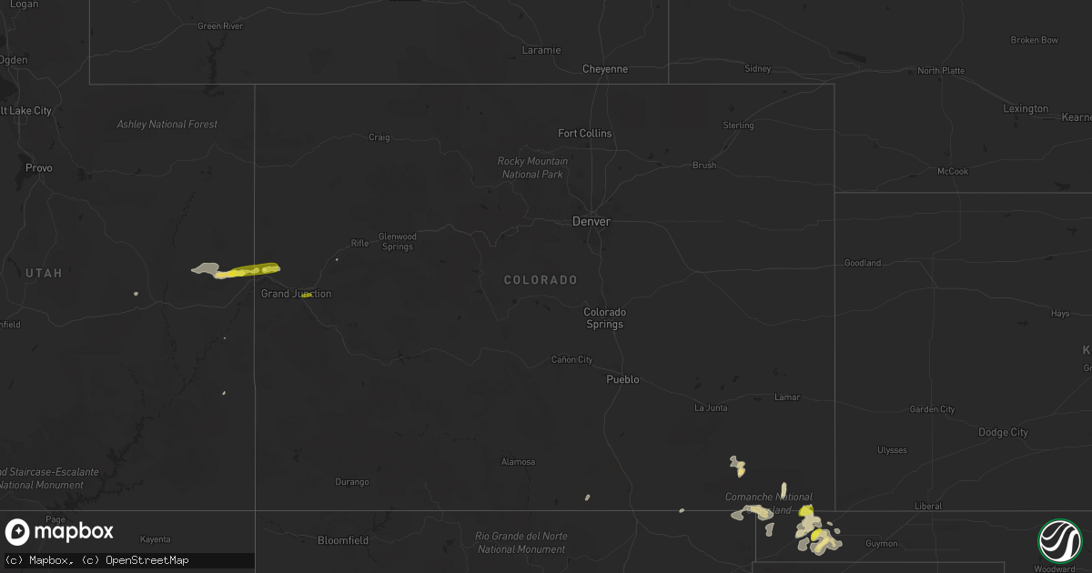
Get this storm
August 21 map
$229
one time, instant access
Download today. No call, no setup
Keep the $229
Bought the map and want the full workflow? Apply the entire $229 to a subscription within 7 days. None of it is wasted.
Every map, not just this one
This buys you this map. Subscription and you get every map we run, in the markets you choose from a few cities to whole states to nationwide. Plus real-time alerts the moment a storm fires.
Contact data
Name, contact info, occupancy, even credit band for addresses in the footprint. You go from where it hit to who to call.
Become the source they trust
Unlimited branding weather history reports on demand. You already have the documented answer ready for the property owner, and you are the one who showed up with it.
Property data and RoofTrace estimates
Pull up any address you have got, its value and the exact code rules for that jurisdiction, straight from One Click Code. Then RoofTrace estimates the squares, pitch, and roof value, priced the way you price.
Storm reports in Colorado
Colorado
| Date | Description |
|---|---|
| 08/21/20186:44 PM CDT | A local report indicates 62 MPH wind near 2 S ALAMOSA |
| 08/21/20181:30 PM CDT | Winds were estimated near 60 mph and the park is reporting numerous tree limbs down. |
| 08/21/20181:18 PM CDT | 2 large cottonwood trees were snapped. One was 100 feet tall and the other 70 feet tall. Both were approximately 7 feet in diameter. 69 mph wind gust measured by home w |
| 08/21/20181:07 PM CDT | Damage to large portion of roof shingles occurred. Report via social media. |
| 08/21/20187:29 AM CDT | At 1229 PM MDT, severe thunderstorms were located along a line extending from 25 miles northwest of Grand Junction to 8 miles northwest of Fruita, moving east at 40 mph. HAZARD...60 mph wind gusts and quarter size hail. SOURCE...Radar indicated. IMPACT...Hail damage to vehicles is expected. Expect wind damage to roofs, siding, and trees. These severe thunderstorms will remain over mainly rural areas of northwestern Mesa and southwestern Garfield Counties.This includes Colorado 139 between mile markers 4 and 16. |
| 08/21/20187:00 AM CDT | At 1200 PM MDT, a severe thunderstorm was located 9 miles east of Palisade, or 20 miles east of Grand Junction, moving east at 30 mph. HAZARD...60 mph wind gusts and quarter size hail. SOURCE...Radar indicated. IMPACT...Hail damage to vehicles is expected. Expect wind damage to roofs, siding, and trees. Locations impacted include... Collbran, Mesa, Plateau City and Molina. This includes Colorado 65 between mile markers 44 and 52. |
| 08/21/20186:53 AM CDT | At 1152 AM MDT, severe thunderstorms were located along a line extending from 41 miles northwest of Grand Junction to 29 miles west of Fruita to 37 miles north of Castle Valley, moving east at 35 mph. HAZARD...60 mph wind gusts and quarter size hail. SOURCE...Radar indicated. IMPACT...Hail damage to vehicles is expected. Expect wind damage to roofs, siding, and trees. These severe thunderstorms will remain over mainly rural areas of northwestern Mesa...western Garfield and northeastern Grand Counties.This includes Colorado 139 between mile markers 10 and 12. |
| 08/21/20186:36 AM CDT | At 1135 AM MDT, a severe thunderstorm was located south of Palisade, or 9 miles east of Grand Junction, moving east at 25 mph. HAZARD...60 mph wind gusts and half dollar size hail. SOURCE...Radar indicated. IMPACT...Hail damage to vehicles is expected. Expect wind damage to roofs, siding, and trees. Locations impacted include... Skyway, Lands End Road, and the west end of the Grand Mesa. This includes Colorado 65 between mile markers 36 and 48. |
| 08/21/20181:02 AM CDT | At 602 PM MDT, a severe thunderstorm was located 17 miles west of Pritchett, or 29 miles west of Springfield, moving northeast at 35 mph. HAZARD...60 mph wind gusts and quarter size hail. SOURCE...Radar indicated. IMPACT...Hail damage to vehicles is expected. Expect wind damage to roofs, siding, and trees. This severe thunderstorm will remain over mainly rural areas of northwestern Baca...east central Las Animas and southeastern Bent Counties. |
| 08/21/201812:38 AM CDT | At 537 PM MDT, a severe thunderstorm was located near Campo, or 17 miles south of Springfield, moving north at 20 mph. HAZARD...60 mph wind gusts and quarter size hail. SOURCE...Radar indicated. IMPACT...Hail damage to vehicles is expected. Expect wind damage to roofs, siding, and trees. Locations impacted include... Springfield, Pritchett, Vilas and Campo. |
| 08/20/201811:10 PM CDT | At 410 PM MDT, a severe thunderstorm was located 9 miles northeast of Branson, or 22 miles north of Des Moines, moving northeast at 15 mph. HAZARD...60 mph wind gusts and quarter size hail. SOURCE...Radar indicated. IMPACT...Hail damage to vehicles is expected. Expect wind damage to roofs, siding, and trees. This severe thunderstorm will remain over mainly rural areas of southeastern Las Animas County. |
| 08/20/201810:39 PM CDT | At 339 PM MDT, a severe thunderstorm was located 10 miles northwest of Capulin, or 16 miles northwest of Des Moines, moving northeast at 10 mph. HAZARD...60 mph wind gusts and quarter size hail. SOURCE...Radar indicated. IMPACT...Hail damage to vehicles is expected. Expect wind damage to roofs, siding, and trees. Locations impacted include... Folsom. |
| 08/20/201810:25 PM CDT | At 325 PM MDT, a severe thunderstorm was located 16 miles south of Stonewall, or 28 miles west of Raton, moving east at 10 mph. HAZARD...60 mph wind gusts and half dollar size hail. SOURCE...Radar indicated. IMPACT...Hail damage to vehicles is expected. Expect wind damage to roofs, siding, and trees. Locations impacted include... Vermejo Park. |
| 08/20/20188:09 PM CDT | At 108 PM MDT, a severe thunderstorm was located near De Beque, or 22 miles northeast of Grand Junction, moving east at 35 mph. HAZARD...60 mph wind gusts and nickel size hail. SOURCE...This storm has had a history of producing damaging wind gusts as well as large hail at Highline Lake State Park. IMPACT...Expect damage to roofs, siding, and trees. Locations impacted include... Parachute, De Beque and Battlement Mesa. This includes Interstate 70 in Colorado between mile markers 59 and85. |
All States Impacted by Hail Map on August 21, 2018
Cities Impacted by Hail Map on August 21, 2018
- Keyes, OK
- Goodwell, OK
- Clearville, PA
- Kim, CO
- Cubero, NM
- Raton, NM
- Beaumont, TX
- Colorado City, AZ
- Cleveland, TX
- Frostburg, MD
- Midlothian, MD
- Madisonville, TX
- Normangee, TX
- Campo, CO
- Boise City, OK
- Stockton, UT
- San Simon, AZ
- Springer, NM
- Cumberland, MD
- Wiley Ford, WV
- Ridgeley, WV
- Rawlings, MD
- Weston, CO
- Waterford, VA
- Paeonian Springs, VA
- Leesburg, VA
- Vernon, UT
- Kanab, UT
- Thompson, UT
- Kenton, OK
- Pritchett, CO
- Grenville, NM
- De Beque, CO
- Clayton, NM
- Humble, TX
- Fairhope, AL
- Flagstaff, AZ
- Texhoma, OK
- Monticello, UT
- Magdalena, NM
- Bosque, NM
- Springerville, AZ
- Hull, TX
- Dayton, TX
- Longwood, FL
- Altamonte Springs, FL
- Inwood, WV
- Winchester, VA
- Bunker Hill, WV
- Gerrardstown, WV
- Fruita, CO
- Loma, CO
- Mack, CO
- Houston, TX
- Daphne, AL
- Vaughn, NM
- Wagon Mound, NM
- Bryan, TX
- Taylorsville, NC
- Ocoee, FL
- Gotha, FL
- Orlando, FL
- Branson, CO
- Parachute, CO
- Green River, UT
- Cimarron, NM
- Sulphur, LA
- Miami, NM
- Franklin, TX
- Moab, UT
- Guadalupita, NM
- Ocate, NM
- Huffman, TX
- Auburndale, FL
- Lake Alfred, FL
- Foley, AL
- Grand Canyon, AZ
- Mobile, AL
- Saraland, AL
- Satsuma, AL
- Glendale, UT
- Trementina, NM
- Mora, NM
- China, TX
- Slidell, LA
- Palisade, CO
- Whitewater, CO
- Grand Junction, CO
- Midway, TX


