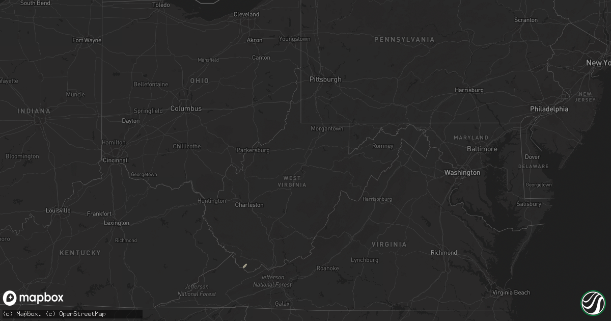
Hail Map in West Virginia on August 19, 2022
Get this storm
August 19 map
$229
one time, instant access
Download today. No call, no setup
Keep the $229
Bought the map and want the full workflow? Apply the entire $229 to a subscription within 7 days. None of it is wasted.
Every map, not just this one
This buys you this map. Subscription and you get every map we run, in the markets you choose from a few cities to whole states to nationwide. Plus real-time alerts the moment a storm fires.
Contact data
Name, contact info, occupancy, even credit band for addresses in the footprint. You go from where it hit to who to call.
Become the source they trust
Unlimited branding weather history reports on demand. You already have the documented answer ready for the property owner, and you are the one who showed up with it.
Property data and RoofTrace estimates
Pull up any address you have got, its value and the exact code rules for that jurisdiction, straight from One Click Code. Then RoofTrace estimates the squares, pitch, and roof value, priced the way you price.
Storm reports in West Virginia
West Virginia
| Date | Description |
|---|---|
| 08/19/20223:01 PM CDT | Mcdowell county 911 advised there is a tree down in the town of welch. Time estimated by radar. |
| 08/19/20222:55 PM CDT | Mcdowell county 911 advised there is a tree down in the town of war. Time estimated by radar. |
| 08/18/202210:43 PM CDT | At 343 PM EDT, a severe thunderstorm was located over War, or 8 miles southwest of Welch, moving northeast at 15 mph. HAZARD...60 mph wind gusts and quarter size hail. SOURCE...Radar indicated. IMPACT...Hail damage to vehicles is expected. Expect wind damage to roofs, siding, and trees. Locations impacted include... Welch, Gary, War, Elbert, Cucumber and Coalwood. |
All States Impacted by Hail Map on August 19, 2022
Cities Impacted by Hail Map on August 19, 2022
- Henderson, NE
- Portland, TN
- Hays, KS
- Victoria, KS
- Clarinda, IA
- Lometa, TX
- Blockton, IA
- Parnell, MO
- Massena, IA
- Cumberland, IA
- Geneva, NE
- Hohenwald, TN
- Centerville, TN
- Syracuse, NE
- Utica, NE
- Beaver Crossing, NE
- Goehner, NE
- Seward, NE
- Keystone, IA
- Grafton, NE
- Sutton, NE
- Lynnville, IA
- Grinnell, IA
- Kellogg, IA
- McCracken, KS
- Pavillion, WY
- War, WV
- Berwind, WV
- Raysal, WV
- Paynesville, WV
- Pierson, FL
- Portal, GA
- Statesboro, GA
- Stuart, IA
- Menlo, IA
- West Des Moines, IA
- Clive, IA
- Windsor Heights, IA
- Urbandale, IA
- Des Moines, IA
- Ackley, IA
- Iowa Falls, IA
- Ashton, ID
- Newdale, ID
- Dighton, KS
- Naples, FL
- Palmyra, NE
- Nemaha, NE
- Auburn, NE
- Brownville, NE
- Deland, FL
- De Leon Springs, FL
- La Fayette, GA
- Armuchee, GA
- Summerville, GA
- Barnard, KS
- Lincoln, KS
- Holland, IA
- Grundy Center, IA
- Dike, IA
- Wellsburg, IA
- Cook, NE
- Talmage, NE
- Brock, NE
- Guthrie Center, IA
- Casey, IA
- Adair, IA
- Shickley, NE
- Davenport, NE
- Kissimmee, FL
- Sylvan Grove, KS
- Fontanelle, IA
- Aurora, NE
- Fairmont, NE
- Ottumwa, IA
- Hopkins, MO
- Palatka, FL
- Satsuma, FL
- Minneapolis, KS
- Garfield, GA
- Twin City, GA
- Dennison, MN
- Julian, NE
- Nebraska City, NE
- Marana, AZ
- Avoca, IA
- Pikeville, TN
- Green, KS
- Harlan, IA
- Steamboat Rock, IA
- Huntsville, UT
- Beloit, KS
- Hunter, KS
- La Crosse, KS
- Bison, KS
- Crescent City, FL
- Bunnell, FL
- Swainsboro, GA
- Riley, KS
- Corning, IA
- Reinbeck, IA
- Omaha, NE
- Bethpage, TN
- Bedford, IA
- Adel, IA
- Pleasant Dale, NE
- Garland, NE
- Charles City, IA
- Shelby, IA
- Hancock, IA
- Mitchellville, IA
- Colfax, IA
- Falun, KS
- Brookville, KS
- Lindsborg, KS
- Ellsworth, KS
- Seville, FL
- Beverly, KS
- Prairie City, IA
- Sterling, NE
- Goodhue, MN
- Johnson, NE
- Peru, NE
- Gentry, MO
- Murfreesboro, TN
- Lebanon, TN
- Waukee, IA
- Pleasant Hill, IA
- Altoona, IA
- Hebron, NE
- Metter, GA
- Deshler, NE
- Kimballton, IA
- Audubon, IA
- Elk Horn, IA
- Pfeifer, KS
- Strang, NE
- Ohiowa, NE
- Osceola, WI
- Jetmore, KS
- Riceboro, GA
- Alexandria, NE
- Tobias, NE
- Daykin, NE
- Grace, ID
- Paradise, KS
- Newton, IA
- Lacona, IA
- Leonardville, KS
- Windermere, FL
- Orlando, FL
- Greenleaf, KS
- Melcher Dallas, IA
- Knoxville, IA
- Tecumseh, NE
- Adams, NE
- Elk Creek, NE
- Sugar Valley, GA
- Adrian, GA
- Kite, GA
- Quinter, KS
- Beryl, UT
- Clay Center, KS
- Guyton, GA
- Fairfax, MO
- Falls City, NE
- Rock Port, MO
- Shubert, NE
- Vinton, IA
- Van Horne, IA
- Mount Auburn, IA
- Garrison, IA
- West Liberty, IA
- Conesville, IA
- Nichols, IA
- Lone Tree, IA
- Muscatine, IA
- Columbus Junction, IA
- Letts, IA
- Hazleton, IA
- Fairbank, IA
- Oelwein, IA
- Anamosa, IA
- Monticello, IA
- Worthington, IA
- Hopkinton, IA


