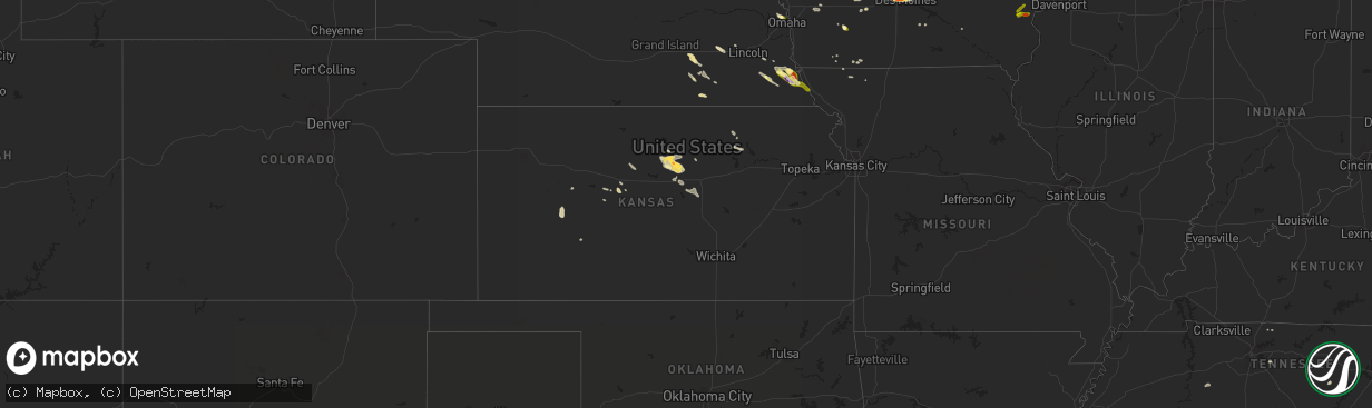
Hail Map in Kansas on August 19, 2022
The weather event in Kansas on August 19, 2022 includes Hail and Wind maps. 15 states and 186 cities were impacted and suffered possible damage. The total estimated number of properties impacted is 220.
Want more than just the map?
Turn this storm into a full workflow.
- Owner + property data so you know who to knock
- OnDemand branded weather history reports to win the "did we even have hail?" argument
- RoofTrace estimate so reps stop guessing numbers at the door
Bought this map? Upgrade within 7 days and we'll credit the $230. (10-15 min setup call)
Hail
Wind
220
Estimated number of impacted properties by a 1.00" hail or larger0
Estimated number of impacted properties by a 1.75" hail or larger0
Estimated number of impacted properties by a 2.50" hail or largerStorm reports in Kansas
Kansas
| Date | Description |
|---|---|
| 08/19/20223:54 PM CDT | Backyard mesonet weather station. |
| 08/19/20221:45 AM CDT | At 645 PM CDT, a severe thunderstorm was located over Walton, or 6 miles west of Peabody, moving southeast at 30 mph. HAZARD...60 mph wind gusts and quarter size hail. SOURCE...Radar indicated. IMPACT...Hail damage to vehicles is expected. Expect wind damage to roofs, siding, and trees. Locations impacted include... Newton, North Newton, Peabody, Whitewater, Potwin, Walton, Elbing, Burns and Newton Airport.This includes Interstate 135 between Mile Markers 23 and 35. |
| 08/19/202212:18 AM CDT | At 518 PM CDT, a severe thunderstorm was located near Lindsborg, moving southeast at 25 mph. HAZARD...60 mph wind gusts and penny size hail. SOURCE...Radar indicated. IMPACT...Expect damage to roofs, siding, and trees. Locations impacted include... Mcpherson, Lindsborg, Galva, Canton, Lehigh, Bridgeport and Roxbury.This includes Interstate 135 between Mile Markers 59 and 80. |
| 08/18/202211:44 PM CDT | At 443 PM CDT, a severe thunderstorm was located 5 miles west of Brookville, or 12 miles east of Kanopolis, moving southeast at 25 mph. HAZARD...60 mph wind gusts and quarter size hail. SOURCE...Radar indicated. IMPACT...Hail damage to vehicles is expected. Expect wind damage to roofs, siding, and trees. Locations impacted include... Lindsborg, Marquette, Brookville, Smolan, Falun, Kanopolis Lake and Kanopolis State Park. |
| 08/18/202210:54 PM CDT | At 354 PM CDT, a severe thunderstorm was located near Beverly, or 6 miles east of Lincoln, moving southeast at 20 mph. HAZARD...60 mph wind gusts and half dollar size hail. SOURCE...Radar indicated. IMPACT...Hail damage to vehicles is expected. Expect wind damage to roofs, siding, and trees. Locations impacted include... Lincoln, Beverly, Glendale and Westfall. This includes Interstate 70 between Mile Markers 229 and 249. |
| 08/18/202210:49 PM CDT | At 349 PM CDT, a severe thunderstorm was located 4 miles northwest of Beverly, moving southeast at 25 mph. HAZARD...Ping pong ball size hail and 60 mph wind gusts. SOURCE...Radar indicated. IMPACT...People and animals outdoors will be injured. Expect hail damage to roofs, siding, windows, and vehicles. Expect wind damage to roofs, siding, and trees. Locations impacted include... Tescott and Culver. |
| 08/18/202210:43 PM CDT | At 342 PM CDT, a severe thunderstorm was located 9 miles south of Alamota, moving south at 20 mph. HAZARD...60 mph wind gusts and quarter size hail. SOURCE...Radar indicated. IMPACT...Hail damage to vehicles is expected. Expect wind damage to roofs, siding, and trees. This severe thunderstorm will remain over mainly rural areas of northeastern Finney, southwestern Ness, northwestern Hodgeman and southeastern Lane Counties. |
| 08/18/202210:07 PM CDT | At 307 PM CDT, a severe thunderstorm was located near Victor, or 10 miles north of Lincoln, moving southeast at 25 mph. HAZARD...Quarter size hail. SOURCE...Radar indicated. IMPACT...Damage to vehicles is expected. Locations impacted include... Lincoln, Beverly, Barnard, Westfall and Ash Grove. This includes Interstate 70 between Mile Markers 229 and 230. |
| 08/18/20228:15 PM CDT | El dorado airport. |
All States Impacted by Hail Map on August 19, 2022
Cities Impacted by Hail Map on August 19, 2022
- Henderson, NE
- Portland, TN
- Hays, KS
- Victoria, KS
- Clarinda, IA
- Lometa, TX
- Blockton, IA
- Parnell, MO
- Massena, IA
- Cumberland, IA
- Geneva, NE
- Hohenwald, TN
- Centerville, TN
- Syracuse, NE
- Utica, NE
- Beaver Crossing, NE
- Goehner, NE
- Seward, NE
- Keystone, IA
- Grafton, NE
- Sutton, NE
- Lynnville, IA
- Grinnell, IA
- Kellogg, IA
- McCracken, KS
- Pavillion, WY
- War, WV
- Berwind, WV
- Raysal, WV
- Paynesville, WV
- Pierson, FL
- Portal, GA
- Statesboro, GA
- Stuart, IA
- Menlo, IA
- West Des Moines, IA
- Clive, IA
- Windsor Heights, IA
- Urbandale, IA
- Des Moines, IA
- Ackley, IA
- Iowa Falls, IA
- Ashton, ID
- Newdale, ID
- Dighton, KS
- Naples, FL
- Palmyra, NE
- Nemaha, NE
- Auburn, NE
- Brownville, NE
- Deland, FL
- De Leon Springs, FL
- La Fayette, GA
- Armuchee, GA
- Summerville, GA
- Barnard, KS
- Lincoln, KS
- Holland, IA
- Grundy Center, IA
- Dike, IA
- Wellsburg, IA
- Cook, NE
- Talmage, NE
- Brock, NE
- Guthrie Center, IA
- Casey, IA
- Adair, IA
- Shickley, NE
- Davenport, NE
- Kissimmee, FL
- Sylvan Grove, KS
- Fontanelle, IA
- Aurora, NE
- Fairmont, NE
- Ottumwa, IA
- Hopkins, MO
- Palatka, FL
- Satsuma, FL
- Minneapolis, KS
- Garfield, GA
- Twin City, GA
- Dennison, MN
- Julian, NE
- Nebraska City, NE
- Marana, AZ
- Avoca, IA
- Pikeville, TN
- Green, KS
- Harlan, IA
- Steamboat Rock, IA
- Huntsville, UT
- Beloit, KS
- Hunter, KS
- La Crosse, KS
- Bison, KS
- Crescent City, FL
- Bunnell, FL
- Swainsboro, GA
- Riley, KS
- Corning, IA
- Reinbeck, IA
- Omaha, NE
- Bethpage, TN
- Bedford, IA
- Adel, IA
- Pleasant Dale, NE
- Garland, NE
- Charles City, IA
- Shelby, IA
- Hancock, IA
- Mitchellville, IA
- Colfax, IA
- Falun, KS
- Brookville, KS
- Lindsborg, KS
- Ellsworth, KS
- Seville, FL
- Beverly, KS
- Prairie City, IA
- Sterling, NE
- Goodhue, MN
- Johnson, NE
- Peru, NE
- Gentry, MO
- Murfreesboro, TN
- Lebanon, TN
- Waukee, IA
- Pleasant Hill, IA
- Altoona, IA
- Hebron, NE
- Metter, GA
- Deshler, NE
- Kimballton, IA
- Audubon, IA
- Elk Horn, IA
- Pfeifer, KS
- Strang, NE
- Ohiowa, NE
- Osceola, WI
- Jetmore, KS
- Riceboro, GA
- Alexandria, NE
- Tobias, NE
- Daykin, NE
- Grace, ID
- Paradise, KS
- Newton, IA
- Lacona, IA
- Leonardville, KS
- Windermere, FL
- Orlando, FL
- Greenleaf, KS
- Melcher Dallas, IA
- Knoxville, IA
- Tecumseh, NE
- Adams, NE
- Elk Creek, NE
- Sugar Valley, GA
- Adrian, GA
- Kite, GA
- Quinter, KS
- Beryl, UT
- Clay Center, KS
- Guyton, GA
- Fairfax, MO
- Falls City, NE
- Rock Port, MO
- Shubert, NE
- Vinton, IA
- Van Horne, IA
- Mount Auburn, IA
- Garrison, IA
- West Liberty, IA
- Conesville, IA
- Nichols, IA
- Lone Tree, IA
- Muscatine, IA
- Columbus Junction, IA
- Letts, IA
- Hazleton, IA
- Fairbank, IA
- Oelwein, IA
- Anamosa, IA
- Monticello, IA
- Worthington, IA
- Hopkinton, IA


