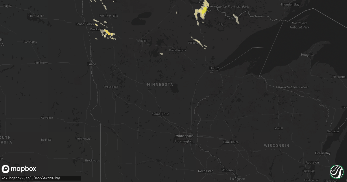
Hail Map in Minnesota on August 19, 2020
Get this storm
August 19 map
$229
one time, instant access
Download today. No call, no setup
Keep the $229
Bought the map and want the full workflow? Apply the entire $229 to a subscription within 7 days. None of it is wasted.
Every map, not just this one
This buys you this map. Subscription and you get every map we run, in the markets you choose from a few cities to whole states to nationwide. Plus real-time alerts the moment a storm fires.
Contact data
Name, contact info, occupancy, even credit band for addresses in the footprint. You go from where it hit to who to call.
Become the source they trust
Unlimited branding weather history reports on demand. You already have the documented answer ready for the property owner, and you are the one who showed up with it.
Property data and RoofTrace estimates
Pull up any address you have got, its value and the exact code rules for that jurisdiction, straight from One Click Code. Then RoofTrace estimates the squares, pitch, and roof value, priced the way you price.
Storm reports in Minnesota
Minnesota
| Date | Description |
|---|---|
| 08/19/20204:45 PM CDT | Delayed report. Dime to quarter size hail fell for approximately 15 minutes. Time and location estimated by radar. |
| 08/19/20207:54 AM CDT | Report posted via social media of hail near maple lake. |
| 08/19/20206:25 AM CDT | Delayed report. Quarter size hail and larger. Report received via facebook. Location and time estimated by radar. |
| 08/19/20204:27 AM CDT | At 926 AM CDT, severe thunderstorms were located along a line extending from 6 miles northeast of Mayville to Climax, moving southeast at 30 mph. HAZARD...Quarter size hail. SOURCE...Radar indicated. IMPACT...Damage to vehicles is expected. Severe thunderstorms will be near... Climax around 930 AM CDT. Nielsville around 935 AM CDT. Cummings around 945 AM CDT. Hillsboro around 955 AM CDT. Lockhart and Caledonia around 1000 AM CDT.Other locations impacted by these severe thunderstorms includeAmerican Crystal Sugar.This includes Interstate 29 between mile markers 93 and 121. |
| 08/19/20202:28 AM CDT | At 728 AM CDT, a severe thunderstorm was located over Mentor, or 27 miles south of Thief River Falls, moving southeast at 25 mph. HAZARD...Ping pong ball size hail. SOURCE...Radar indicated. IMPACT...People and animals outdoors will be injured. Expect damage to roofs, siding, windows, and vehicles. Locations impacted include... McIntosh, Erskine, Winger, Mentor, Maple Bay, Bejou and Rindal. |
| 08/19/20202:14 AM CDT | At 714 PM CDT, a severe thunderstorm was located over Crane Lake, or 27 miles north of Lake Vermilion, moving southeast at 30 mph. HAZARD...Half dollar size hail. SOURCE...Radar indicated. IMPACT...Damage to vehicles is expected. This severe thunderstorm will remain over mainly rural areas of north central St. Louis County, including the following locations... Echo Lake, Loon Lake, Sand Point Lake and Lac la Croix. |
| 08/19/20202:06 AM CDT | Mesonet station kitm5 karlstad mn. |
| 08/19/20201:45 AM CDT | Corrects previous tstm wnd gst report from 2 ne karlstad. Mesonet station kitm5 karlstad mn. Time estimated based on radar. |
| 08/19/20201:45 AM CDT | Peak wind measured at the karlstad raws station. Time estimated based on radar. |
| 08/19/20201:45 AM CDT | Minor damage to house and small branches down in the yard |
| 08/19/20201:44 AM CDT | At 644 AM CDT, a severe thunderstorm was located over Gentilly, or 24 miles southwest of Thief River Falls, moving east at 30 mph. HAZARD...Quarter size hail. SOURCE...Radar indicated. IMPACT...Damage to vehicles is expected. Locations impacted include... Crookston, Red Lake Falls, Fertile, Erskine, Oklee, Plummer and Winger. |
| 08/19/20201:15 AM CDT | Peak wind measured at the rwis station mn024. |
| 08/19/20201:15 AM CDT | Mesonet station mn024 donaldson mn 1 w. |
| 08/19/20201:07 AM CDT | Peak wind gust measured by ndawn sensor |
| 08/19/20201:05 AM CDT | A local report indicates 1.50 inch wind near 2 S HALLOCK |
| 08/19/20201:04 AM CDT | At 604 AM CDT, a severe thunderstorm was located over Espelie, or 22 miles east of Thief River Falls, moving east at 30 mph. HAZARD...Half dollar size hail. SOURCE...Radar indicated. IMPACT...Damage to vehicles is expected. Locations impacted include... Grygla, Goodridge, Thorhult, Carmel, Malcolm, High Landing and Espelie. |
| 08/19/20201:00 AM CDT | Ndawn station at 6 sw kennedy measured 60 mph wind gust. Corrects previous lsr. |
| 08/19/202012:50 AM CDT | A local report indicates 1.25 inch wind near ORLEANS |
| 08/19/202012:26 AM CDT | At 526 AM CDT, severe thunderstorms were located along a line extending from 6 miles west of Carpenters Corner to Bygland, moving southeast at 20 mph. This storm has a history of producing quarter to half dollar sized hail. HAZARD...Half dollar size hail. SOURCE...Radar indicated. IMPACT...Damage to vehicles is expected. Locations impacted include... Crookston, Fisher, Euclid, Gentilly, Angus, Eldred and Huot. |
| 08/18/202011:57 PM CDT | At 456 AM CDT, a severe thunderstorm was located over Grand Forks, moving east at 10 mph. HAZARD...Quarter size hail. SOURCE...Radar indicated. IMPACT...Damage to vehicles is expected. Locations impacted include... Grand Forks, East Grand Forks, Mallory, Bygland, Davidson and Key West.This includes Interstate 29 between mile markers 136 and 143. |
| 08/18/202011:52 PM CDT | At 452 AM CDT, a severe thunderstorm was located near Gatzke, or 26 miles south of Roseau, moving east at 15 mph. HAZARD...Quarter size hail. SOURCE...Radar indicated. IMPACT...Damage to vehicles is expected. Locations impacted include... Grygla, Wannaska, Gatzke, Hayes Lake State Park, Carmel, Casperson and Skime. |
| 08/18/202011:38 PM CDT | At 438 AM CDT, a severe thunderstorm was located near Dakota Junction, or near Thief River Falls, moving east at 10 mph. HAZARD...Half dollar size hail. SOURCE...Radar indicated. IMPACT...Damage to vehicles is expected. Locations impacted include... Goodridge and Mavie. |
| 08/18/202011:15 PM CDT | At 414 AM CDT, a severe thunderstorm was located near Holt, or 11 miles north of Thief River Falls, moving east at 10 mph. HAZARD...Half dollar size hail. SOURCE...Radar indicated. IMPACT...Damage to vehicles is expected. This severe thunderstorm will remain over mainly rural areas of southeastern Marshall County. |
| 08/18/202010:23 PM CDT | At 323 AM CDT, a severe thunderstorm was located near Holt, or 11 miles northwest of Thief River Falls, moving southeast at 15 mph. HAZARD...Ping pong ball size hail. SOURCE...Radar indicated. IMPACT...People and animals outdoors will be injured. Expect damage to roofs, siding, windows, and vehicles. Locations impacted include... Holt. |
| 08/18/202010:16 PM CDT | At 316 AM CDT, a severe thunderstorm was located near Holt, or 12 miles northwest of Thief River Falls, moving southeast at 15 mph. HAZARD...Quarter size hail. SOURCE...Radar indicated. IMPACT...Damage to vehicles is expected. Locations impacted include... Holt, Rosewood and Dakota Junction. |
| 08/18/20207:21 PM CDT | Corrects previous hail report from crane lake. Delayed report. Dime to quarter size hail fell for approximately 15 minutes. Time and location estimated by radar. |
| 08/18/20207:21 PM CDT | Photos were received via social media showing half dollar sized hail at a resort in crane lake. Time estimated by radar. |
All States Impacted by Hail Map on August 19, 2020
Cities Impacted by Hail Map on August 19, 2020
- Wetumpka, AL
- Montgomery, AL
- Strandquist, MN
- Remer, MN
- Mentor, MN
- Red Lake Falls, MN
- Crane Lake, MN
- Toxey, AL
- Gilbertown, AL
- Fertile, MN
- Dewey, AZ
- Newfolden, MN
- Headland, AL
- Madison, AL
- Taft, TX
- Hallock, MN
- Kennedy, MN
- Camp Verde, AZ
- Crandall, GA
- Cisco, GA
- Defuniak Springs, FL
- Orr, MN
- Stephen, MN
- Colquitt, GA
- Saluda, NC
- Euclid, MN
- Trenton, GA
- Greenville, AL
- Donalsonville, GA
- Vinemont, AL
- Addison, AL
- Falkville, AL
- Erskine, MN
- Sylvania, AL
- Rainsville, AL
- Dubois, ID
- Fosston, MN
- Winger, MN
- Dalton, GA
- Chatsworth, GA
- Portland, TX
- Gregory, TX
- Hanahan, SC
- Lodgepole, NE
- Uriah, AL
- Titus, AL
- Lancaster, MN
- Bogalusa, LA
- Franklinton, LA
- Karlstad, MN
- Crookston, MN
- Sedona, AZ
- Clayton, AL
- Rome, GA
- Wiggins, MS
- Perkinston, MS
- Altha, FL
- Greensboro, GA
- Rocklake, ND
- Atmore, AL
- McDavid, FL
- Century, FL
- Ringgold, GA
- Tunnel Hill, GA
- Fairmount, GA
- Rydal, GA
- Pembina, ND
- Jupiter, FL
- Red Lodge, MT
- Roscoe, MT
- Charleston, SC
- Marietta, GA
- New Orleans, LA
- Dothan, AL
- Houston, AL
- Edgefield, SC
- Trenton, SC
- Johnston, SC
- Halma, MN
- Donaldson, MN
- Lake Bronson, MN
- Saint Vincent, MN
- Dunlap, TN
- Mcintosh, MN
- Beltrami, MN
- Millbrook, AL
- Deatsville, AL
- Little River, AL
- Stockton, AL
- Sheridan, MT
- McIntosh, AL
- Marianna, FL
- Millsboro, DE
- Laurel, DE
- Eufaula, AL
- Flat Rock, NC
- Cook, MN
- Parsonsburg, MD
- Woodstock, GA
- Braithwaite, LA
- Saint Bernard, LA
- Rolla, ND
- Concepcion, TX
- Fort Payne, AL
- Alice, TX
- Humboldt, MN
- Bathgate, ND
- Iron, MN
- Mountain Iron, MN
- Hibbing, MN
- Chisholm, MN
- Buhl, MN
- Somerville, AL
- Decatur, AL
- Lucedale, MS
- McLain, MS
- Columbia, AL
- Hartselle, AL
- Georgiana, AL
- Strathcona, MN
- Greenbush, MN
- Dillon, MT
- Damascus, GA
- Blakely, GA
- Middle River, MN
- Rockford, AL
- Marion, NC
- Athens, GA
- Nicholson, GA
- Joshua Tree, CA
- Armuchee, GA
- Brooks, MN
- Mcminnville, TN
- Goose Creek, SC
- Big Falls, MN
- Cullman, AL
- Eveleth, MN
- Makinen, MN
- Rocky Face, GA
- Jasper, GA
- Seaford, DE
- Georgetown, DE
- Estill Springs, TN
- Tullahoma, TN
- Jakin, GA
- Hollytree, AL
- Poplarville, MS
- Iron City, GA
- Easley, SC
- Prattville, AL
- Encino, TX
- Forbes, MN
- Courtland, VA
- Boykins, VA
- Capron, VA
- Newsoms, VA


