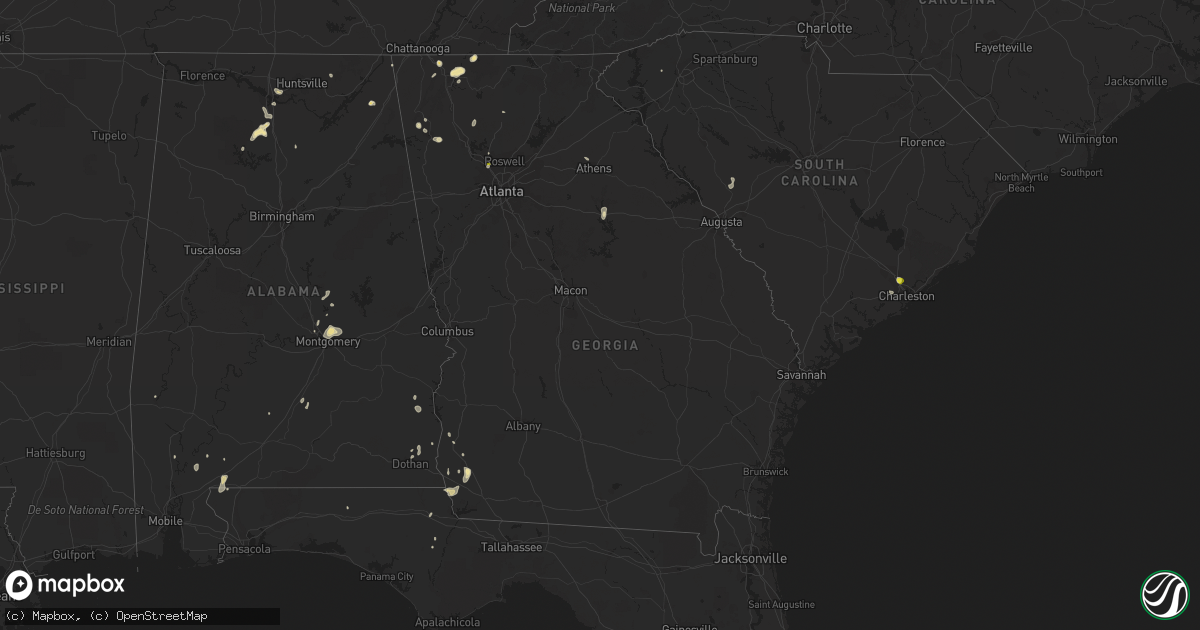
Hail Map in Georgia on August 19, 2020
Get this storm
August 19 map
$229
one time, instant access
Download today. No call, no setup
Keep the $229
Bought the map and want the full workflow? Apply the entire $229 to a subscription within 7 days. None of it is wasted.
Every map, not just this one
This buys you this map. Subscription and you get every map we run, in the markets you choose from a few cities to whole states to nationwide. Plus real-time alerts the moment a storm fires.
Contact data
Name, contact info, occupancy, even credit band for addresses in the footprint. You go from where it hit to who to call.
Become the source they trust
Unlimited branding weather history reports on demand. You already have the documented answer ready for the property owner, and you are the one who showed up with it.
Property data and RoofTrace estimates
Pull up any address you have got, its value and the exact code rules for that jurisdiction, straight from One Click Code. Then RoofTrace estimates the squares, pitch, and roof value, priced the way you price.
Storm reports in Georgia
Georgia
| Date | Description |
|---|---|
| 08/19/20206:30 PM CDT | 1 tree down. |
| 08/19/20205:20 PM CDT | A tree was reported down in the 3900 block of paper mill road se. |
| 08/19/20205:13 PM CDT | Quarter sized hail was reported near the intersection of old canton road and sewell mill road. |
| 08/19/20205:11 PM CDT | A tree was reported down in the 1800 block of murdock road. |
| 08/19/20204:50 PM CDT | Several trees down |
| 08/19/20204:44 PM CDT | Quarter sized hail was reported near the intersection of sandy plains road and scufflegrit road. |
| 08/19/20204:30 PM CDT | Several trees down |
| 08/19/20204:29 PM CDT | A tree and power lines were reported down near the intersection of knox bridge highway and upper sweetwater trail. |
| 08/19/20204:20 PM CDT | Several trees down |
| 08/19/20203:54 PM CDT | Two trees were reported dowm along retreat ridge southeast. |
| 08/19/20203:48 PM CDT | A tree was reported down in a yard along emerald drive. |
| 08/19/202012:11 PM CDT | A tree was reported down on a power line in the 600 block of lake hills drive. |
| 08/19/20201:56 AM CDT | At 656 PM EDT, a severe thunderstorm was located near Colquitt, moving southeast at 15 mph. HAZARD...60 mph wind gusts and penny size hail. SOURCE...Radar indicated. IMPACT...Expect damage to roofs, siding, and trees. Locations impacted include... Colquitt, Donalsonville, Damascus, Babcock, Eldorendo, Mayhaw, Boykin, Cuba, Enterprise, Harmony Church Rd/hwy 45, Old Damascus, Jeterville and Hentown. |
| 08/19/202012:51 AM CDT | At 551 PM EDT, a severe thunderstorm was located over Sandy Plains, or near Marietta, and is nearly stationary. HAZARD...Quarter size hail. SOURCE...Radar indicated. IMPACT...Damage to vehicles is expected. Locations impacted include... Marietta, Sandy Springs, Roswell, Alpharetta, Dunwoody, Woodstock, Mount Bethel, Union Hill, White Water Park, Sweat Mountain, Birmingham, Sandy Plains and Dobbins Air Reserve Base. |
| 08/18/20209:50 PM CDT | At 250 PM EDT, a severe thunderstorm was located over Dawnville, or near Dalton, moving south at 5 mph. HAZARD...60 mph wind gusts and quarter size hail. SOURCE...Radar indicated. IMPACT...Hail damage to vehicles is expected. Expect wind damage to roofs, siding, and trees. Locations impacted include... Dalton and Dawnville. |
| 08/18/20209:37 PM CDT | At 237 PM EDT, a severe thunderstorm was located over Ringgold, moving northeast at 25 mph. HAZARD...60 mph wind gusts and quarter size hail. SOURCE...Radar indicated. IMPACT...Hail damage to vehicles is expected. Expect wind damage to roofs, siding, and trees. Locations impacted include... Ringgold, Varnell, Cohutta, Graysville, Red Clay S.p., Indian Springs and Apison. |
All States Impacted by Hail Map on August 19, 2020
Cities Impacted by Hail Map on August 19, 2020
- Wetumpka, AL
- Montgomery, AL
- Strandquist, MN
- Remer, MN
- Mentor, MN
- Red Lake Falls, MN
- Crane Lake, MN
- Toxey, AL
- Gilbertown, AL
- Fertile, MN
- Dewey, AZ
- Newfolden, MN
- Headland, AL
- Madison, AL
- Taft, TX
- Hallock, MN
- Kennedy, MN
- Camp Verde, AZ
- Crandall, GA
- Cisco, GA
- Defuniak Springs, FL
- Orr, MN
- Stephen, MN
- Colquitt, GA
- Saluda, NC
- Euclid, MN
- Trenton, GA
- Greenville, AL
- Donalsonville, GA
- Vinemont, AL
- Addison, AL
- Falkville, AL
- Erskine, MN
- Sylvania, AL
- Rainsville, AL
- Dubois, ID
- Fosston, MN
- Winger, MN
- Dalton, GA
- Chatsworth, GA
- Portland, TX
- Gregory, TX
- Hanahan, SC
- Lodgepole, NE
- Uriah, AL
- Titus, AL
- Lancaster, MN
- Bogalusa, LA
- Franklinton, LA
- Karlstad, MN
- Crookston, MN
- Sedona, AZ
- Clayton, AL
- Rome, GA
- Wiggins, MS
- Perkinston, MS
- Altha, FL
- Greensboro, GA
- Rocklake, ND
- Atmore, AL
- McDavid, FL
- Century, FL
- Ringgold, GA
- Tunnel Hill, GA
- Fairmount, GA
- Rydal, GA
- Pembina, ND
- Jupiter, FL
- Red Lodge, MT
- Roscoe, MT
- Charleston, SC
- Marietta, GA
- New Orleans, LA
- Dothan, AL
- Houston, AL
- Edgefield, SC
- Trenton, SC
- Johnston, SC
- Halma, MN
- Donaldson, MN
- Lake Bronson, MN
- Saint Vincent, MN
- Dunlap, TN
- Mcintosh, MN
- Beltrami, MN
- Millbrook, AL
- Deatsville, AL
- Little River, AL
- Stockton, AL
- Sheridan, MT
- McIntosh, AL
- Marianna, FL
- Millsboro, DE
- Laurel, DE
- Eufaula, AL
- Flat Rock, NC
- Cook, MN
- Parsonsburg, MD
- Woodstock, GA
- Braithwaite, LA
- Saint Bernard, LA
- Rolla, ND
- Concepcion, TX
- Fort Payne, AL
- Alice, TX
- Humboldt, MN
- Bathgate, ND
- Iron, MN
- Mountain Iron, MN
- Hibbing, MN
- Chisholm, MN
- Buhl, MN
- Somerville, AL
- Decatur, AL
- Lucedale, MS
- McLain, MS
- Columbia, AL
- Hartselle, AL
- Georgiana, AL
- Strathcona, MN
- Greenbush, MN
- Dillon, MT
- Damascus, GA
- Blakely, GA
- Middle River, MN
- Rockford, AL
- Marion, NC
- Athens, GA
- Nicholson, GA
- Joshua Tree, CA
- Armuchee, GA
- Brooks, MN
- Mcminnville, TN
- Goose Creek, SC
- Big Falls, MN
- Cullman, AL
- Eveleth, MN
- Makinen, MN
- Rocky Face, GA
- Jasper, GA
- Seaford, DE
- Georgetown, DE
- Estill Springs, TN
- Tullahoma, TN
- Jakin, GA
- Hollytree, AL
- Poplarville, MS
- Iron City, GA
- Easley, SC
- Prattville, AL
- Encino, TX
- Forbes, MN
- Courtland, VA
- Boykins, VA
- Capron, VA
- Newsoms, VA


