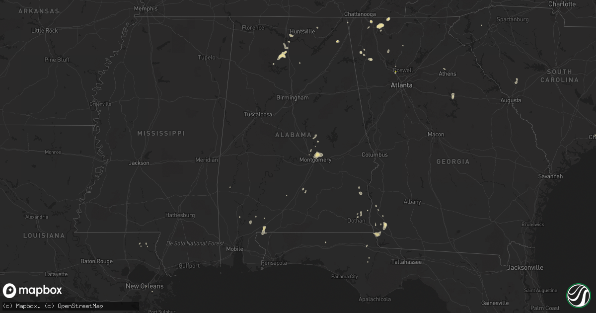
Hail Map in Alabama on August 19, 2020
Get this storm
August 19 map
$229
one time, instant access
Download today. No call, no setup
Keep the $229
Bought the map and want the full workflow? Apply the entire $229 to a subscription within 7 days. None of it is wasted.
Every map, not just this one
This buys you this map. Subscription and you get every map we run, in the markets you choose from a few cities to whole states to nationwide. Plus real-time alerts the moment a storm fires.
Contact data
Name, contact info, occupancy, even credit band for addresses in the footprint. You go from where it hit to who to call.
Become the source they trust
Unlimited branding weather history reports on demand. You already have the documented answer ready for the property owner, and you are the one who showed up with it.
Property data and RoofTrace estimates
Pull up any address you have got, its value and the exact code rules for that jurisdiction, straight from One Click Code. Then RoofTrace estimates the squares, pitch, and roof value, priced the way you price.
Storm reports in Alabama
Alabama
| Date | Description |
|---|---|
| 08/19/20205:36 PM CDT | A large flag pole and large tree limbs down in hartselle. |
| 08/19/20205:23 PM CDT | A tree was knocked down on the southbound portion of i-65 just before the tennessee river. Time estimated by radar. |
| 08/19/20202:33 PM CDT | Corrects previous tstm wnd dmg report from holly pond. Multiple trees were knocked down blocking u.s. Highway 278 in holly pond. Trees were also down at other locations |
| 08/19/20202:33 PM CDT | Corrects previous tstm wnd dmg report from 2 w holly pond. Thunderstorm winds caused damage to a chicken house on cr 1682 just north of cr 1650. |
| 08/19/20202:33 PM CDT | Multiple trees were knocked down blocking u.s. Highway 278 in holly pond. Trees were also down at other locations in this part of the county. |
| 08/19/20201:48 PM CDT | Four trees down along woods road. |
| 08/19/20201:45 PM CDT | One tree down on highway 79 and blocking part of the roadway. |
| 08/19/20204:38 AM CDT | At 938 PM CDT, a severe thunderstorm was located over northern Montgomery, moving east at 5 mph. HAZARD...60 mph wind gusts and quarter size hail. SOURCE...Radar indicated. IMPACT...Hail damage to vehicles is expected. Expect wind damage to roofs, siding, and trees. Locations impacted include... Montgomery, Millbrook, Wetumpka, Coosada, Montgomery Zoo, Boylston, Alabama State University, Auburn University In Montgomery, Bob Woodruff Lake, Emerald Mountain, Eastdale Mall, Maxwell Air Force Base, Montgomery Riverwalk Stadium, Blue Ridge, Lagoon Park, Gunter Air Force Base, Alabama State Capitol, Mitylene and Tallapoosa Water Plant. |
| 08/19/20201:09 AM CDT | At 609 PM CDT, a severe thunderstorm was located 11 miles west of McCullough, or 18 miles northwest of Atmore, moving north at 15 mph. HAZARD...60 mph wind gusts and nickel size hail. SOURCE...Radar indicated. IMPACT...Expect damage to roofs, siding, and trees. This severe thunderstorm will remain over mainly rural areas of southwestern Monroe, north central Baldwin and southeastern Clarke Counties. |
| 08/19/202012:02 AM CDT | At 502 PM CDT, a severe thunderstorm was located near Falkville, or near Hartselle, moving north at 5 mph. HAZARD...60 mph wind gusts and nickel size hail. SOURCE...Radar indicated. IMPACT...Expect damage to roofs, siding, and trees. Locations impacted include... Hartselle, Falkville, West Point, Lacon, Neel, Massey and Battleground. |
| 08/18/202010:34 PM CDT | At 333 PM CDT, a severe thunderstorm was located 8 miles northeast of Gurley, or 12 miles east of Moores Mill, moving northeast at 20 mph. HAZARD...60 mph wind gusts and nickel size hail. SOURCE...Radar indicated. IMPACT...Expect damage to roofs, siding, and trees. Locations impacted include... Skyline, Gurley, Pleasant Groves, Maysville, Princeton, Trenton, Garth, Hollytree, Brownsboro and Larkin. |
| 08/18/20209:17 PM CDT | Sporadic tree damage near wetumpka... Including georgia rd and us hwy 231... And s shelby st. |
| 08/18/20208:17 PM CDT | At 117 PM CDT, a severe thunderstorm was located over Sylvania, or near Rainsville, and is nearly stationary. HAZARD...60 mph wind gusts and nickel size hail. SOURCE...Radar indicated. IMPACT...Expect damage to roofs, siding, and trees. Locations impacted include... Fort Payne, Rainsville, Henagar, Sylvania, Powell and Pine Ridge. |
| 08/18/20207:54 PM CDT | Tree blown onto a fence. Pea size hail also reported. |
| 08/18/20207:00 PM CDT | A few trees were blown down in northern chambers county. |
All States Impacted by Hail Map on August 19, 2020
Cities Impacted by Hail Map on August 19, 2020
- Wetumpka, AL
- Montgomery, AL
- Strandquist, MN
- Remer, MN
- Mentor, MN
- Red Lake Falls, MN
- Crane Lake, MN
- Toxey, AL
- Gilbertown, AL
- Fertile, MN
- Dewey, AZ
- Newfolden, MN
- Headland, AL
- Madison, AL
- Taft, TX
- Hallock, MN
- Kennedy, MN
- Camp Verde, AZ
- Crandall, GA
- Cisco, GA
- Defuniak Springs, FL
- Orr, MN
- Stephen, MN
- Colquitt, GA
- Saluda, NC
- Euclid, MN
- Trenton, GA
- Greenville, AL
- Donalsonville, GA
- Vinemont, AL
- Addison, AL
- Falkville, AL
- Erskine, MN
- Sylvania, AL
- Rainsville, AL
- Dubois, ID
- Fosston, MN
- Winger, MN
- Dalton, GA
- Chatsworth, GA
- Portland, TX
- Gregory, TX
- Hanahan, SC
- Lodgepole, NE
- Uriah, AL
- Titus, AL
- Lancaster, MN
- Bogalusa, LA
- Franklinton, LA
- Karlstad, MN
- Crookston, MN
- Sedona, AZ
- Clayton, AL
- Rome, GA
- Wiggins, MS
- Perkinston, MS
- Altha, FL
- Greensboro, GA
- Rocklake, ND
- Atmore, AL
- McDavid, FL
- Century, FL
- Ringgold, GA
- Tunnel Hill, GA
- Fairmount, GA
- Rydal, GA
- Pembina, ND
- Jupiter, FL
- Red Lodge, MT
- Roscoe, MT
- Charleston, SC
- Marietta, GA
- New Orleans, LA
- Dothan, AL
- Houston, AL
- Edgefield, SC
- Trenton, SC
- Johnston, SC
- Halma, MN
- Donaldson, MN
- Lake Bronson, MN
- Saint Vincent, MN
- Dunlap, TN
- Mcintosh, MN
- Beltrami, MN
- Millbrook, AL
- Deatsville, AL
- Little River, AL
- Stockton, AL
- Sheridan, MT
- McIntosh, AL
- Marianna, FL
- Millsboro, DE
- Laurel, DE
- Eufaula, AL
- Flat Rock, NC
- Cook, MN
- Parsonsburg, MD
- Woodstock, GA
- Braithwaite, LA
- Saint Bernard, LA
- Rolla, ND
- Concepcion, TX
- Fort Payne, AL
- Alice, TX
- Humboldt, MN
- Bathgate, ND
- Iron, MN
- Mountain Iron, MN
- Hibbing, MN
- Chisholm, MN
- Buhl, MN
- Somerville, AL
- Decatur, AL
- Lucedale, MS
- McLain, MS
- Columbia, AL
- Hartselle, AL
- Georgiana, AL
- Strathcona, MN
- Greenbush, MN
- Dillon, MT
- Damascus, GA
- Blakely, GA
- Middle River, MN
- Rockford, AL
- Marion, NC
- Athens, GA
- Nicholson, GA
- Joshua Tree, CA
- Armuchee, GA
- Brooks, MN
- Mcminnville, TN
- Goose Creek, SC
- Big Falls, MN
- Cullman, AL
- Eveleth, MN
- Makinen, MN
- Rocky Face, GA
- Jasper, GA
- Seaford, DE
- Georgetown, DE
- Estill Springs, TN
- Tullahoma, TN
- Jakin, GA
- Hollytree, AL
- Poplarville, MS
- Iron City, GA
- Easley, SC
- Prattville, AL
- Encino, TX
- Forbes, MN
- Courtland, VA
- Boykins, VA
- Capron, VA
- Newsoms, VA


