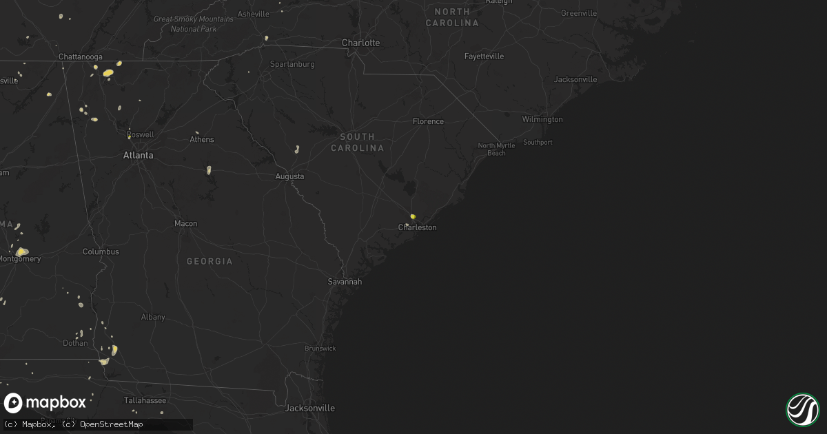
Hail Map on August 19, 2020
Get this storm
August 19 map
$229
one time, instant access
Download today. No call, no setup
Keep the $229
Bought the map and want the full workflow? Apply the entire $229 to a subscription within 7 days. None of it is wasted.
Every map, not just this one
This buys you this map. Subscription and you get every map we run, in the markets you choose from a few cities to whole states to nationwide. Plus real-time alerts the moment a storm fires.
Contact data
Name, contact info, occupancy, even credit band for addresses in the footprint. You go from where it hit to who to call.
Become the source they trust
Unlimited branding weather history reports on demand. You already have the documented answer ready for the property owner, and you are the one who showed up with it.
Property data and RoofTrace estimates
Pull up any address you have got, its value and the exact code rules for that jurisdiction, straight from One Click Code. Then RoofTrace estimates the squares, pitch, and roof value, priced the way you price.
States Impacted by Hail Map on August 19, 2020
Storm reports
Virginia
| Date | Description |
|---|---|
| 08/19/20204:50 PM CDT | Southampton county sheriff reported multiple trees down south of highway 58 near newsoms. Time estimated via radar. |
Delaware
| Date | Description |
|---|---|
| 08/19/20205:20 AM CDT | At 1020 AM EDT, a severe thunderstorm was located 9 miles southwest of Vienna, or 14 miles southeast of Cambridge, moving east at 30 mph. HAZARD...60 mph wind gusts and nickel size hail. SOURCE...Radar indicated. IMPACT...Expect damage to trees and powerlines. This severe thunderstorm will be near, Vienna around 1035 AM EDT. Hebron and Sharptown around 1050 AM EDT. Salisbury around 1055 AM EDT. Delmar around 1100 AM EDT.Other locations impacted by this severe thunderstorm includeGalestown, Green Hill, Catchpenny, Wetipquin, Brookview, Eldorado,Royal Oak, Mardela Springs, Chesapeake Heights and Elliott. |
South Carolina
| Date | Description |
|---|---|
| 08/19/20203:07 PM CDT | Hanahan police department reported large hail. |
| 08/19/20202:56 PM CDT | Lake cunningham fire dept reported a large tree and power lines down on memorial drive extension. |
| 08/19/20202:56 PM CDT | At least a couple of trees blown over and large limbs down in the lake cunningham recreation area. |
| 08/18/202011:05 PM CDT | At 405 PM EDT, a severe thunderstorm was located over Hanahan, moving north at 5 mph. HAZARD...60 mph wind gusts and quarter size hail. SOURCE...Radar indicated. IMPACT...Minor hail damage to vehicles is possible. Expect wind damage to trees and powerlines. Locations impacted include... North Charleston, Goose Creek, Hanahan, Naval Weapons Station Charleston, Ladson, Daniel Island, I-26/I-526 Interchange, West Ashley, Crowfield Plantation, Charleston Airport, College Park, Magnolia Gardens and Don Holt Bridge.This warning includes... I-26 between mile markers 201 and 218. I-526 between mile markers 14 and 25. |
| 08/18/202010:45 PM CDT | At 345 PM EDT, a severe thunderstorm was located 13 miles southwest of Columbus, or near Tigerville, moving southeast at 10 mph. HAZARD...60 mph wind gusts and nickel size hail. SOURCE...Radar indicated. IMPACT...Expect damage to trees and power lines. Locations impacted include... Paris Mountain State Park, Tigerville, Lake Robinson, Glassy Mountain, North Saluda Reservoir, Taylors and Greer. |
| 08/18/202010:00 PM CDT | At 300 PM EDT, a severe thunderstorm was located 6 miles west of Columbus, or near Saluda, moving southeast at 15 mph. HAZARD...60 mph wind gusts and penny size hail. SOURCE...Radar indicated. IMPACT...Expect damage to trees and power lines. Locations impacted include... Columbus, Landrum, Tryon, Saluda, Tuxedo, North Saluda Reservoir, Glassy Mountain, Dana, Gowensville and East Flat Rock. |
Montana
| Date | Description |
|---|---|
| 08/19/20201:16 AM CDT | At 615 PM MDT, a severe thunderstorm was located near Sheridan, moving east at 30 mph. HAZARD...60 mph wind gusts and half dollar size hail. SOURCE...Radar indicated. IMPACT...Hail damage to vehicles is expected. Expect wind damage to roofs, siding, and trees. Locations impacted include... Sheridan and Norris. |
| 08/19/20201:03 AM CDT | Mesonet station mtdpc deep creek us-12 |
| 08/19/202012:15 AM CDT | At 513 PM MDT, a severe thunderstorm was located 9 miles west of Spencer, or 17 miles northwest of Dubois, moving east northeast at 15 to 20mph. HAZARD...Quarter size hail and wind gusts of around 40 mph. SOURCE...Radar indicated. IMPACT...Damage to vehicles is expected. Locations impacted include... Spencer, Monida Pass and Humphrey. |
Tennessee
| Date | Description |
|---|---|
| 08/18/202010:11 PM CDT | At 311 PM EDT, a severe thunderstorm was located over Eton, or near Chatsworth, moving northeast at 20 mph. HAZARD...60 mph wind gusts and quarter size hail. SOURCE...Radar indicated. IMPACT...Hail damage to vehicles is expected. Expect wind damage to roofs, siding, and trees. Locations impacted include... Chatsworth, Eton, Crandall, Conasauga Lake, Tennga, Beaverdale, Dawnville, Sumac, Cisco and Gregory. |
Massachusetts
| Date | Description |
|---|---|
| 08/19/202012:28 AM CDT | At 527 PM EDT, a severe thunderstorm was located over Shrewsbury, moving east at 40 mph. HAZARD...60 mph wind gusts and penny size hail. SOURCE...Radar indicated. IMPACT...Expect damage to trees and power lines. Locations impacted include... Boston, Worcester, Newton, Framingham, Brookline, Marlborough, Shrewsbury, Natick, Franklin, Needham, Norwood, Milford, Wellesley, Stoughton, Dedham, Walpole, Mansfield, Easton, Canton and Westborough. |
Florida
| Date | Description |
|---|---|
| 08/19/20204:40 PM CDT | Tree limbs down along county road 305. |
| 08/19/20204:10 PM CDT | Power line down. |
| 08/19/20202:53 AM CDT | At 753 PM EDT/653 PM CDT/, a severe thunderstorm was located 11 miles west of West Bainbridge, or 12 miles west of Bainbridge, moving southeast at 5 mph. HAZARD...60 mph wind gusts and penny size hail. SOURCE...Radar indicated. IMPACT...Expect damage to roofs, siding, and trees. Locations impacted include... Bainbridge, Donalsonville, West Bainbridge, Chattahoochee, Iron City, Brinson, Hanover, Ausmac, Reynoldsville, Little Hope, Rosedale, Recovery, Decatur Co A/P, Jinks, Riverturn, Sharphagen, Hornsville, Donaldsonville A/P, Seminole State Park and Steam Mill. |
| 08/19/20202:18 AM CDT | At 718 PM EDT/618 PM CDT/, a severe thunderstorm was located near Donalsonville, moving southeast at 5 mph. HAZARD...60 mph wind gusts and penny size hail. SOURCE...Radar indicated. IMPACT...Expect damage to roofs, siding, and trees. Locations impacted include... Donalsonville, Iron City, Brinson, Seminole State Park, Steam Mill, Desser, Reynoldsville, Davis Park, Little Hope, Lela, Lovedale, Haynes, Drakes Still, Jinks, Cyrene, Riverturn, Sharphagen, Hornsville, Donaldsonville A/P and Fairchild. |
| 08/18/202011:51 PM CDT | At 451 PM EDT, a severe thunderstorm was located 7 miles northwest of Crawfordville, moving south at 10 mph. HAZARD...60 mph wind gusts. SOURCE...Radar indicated. IMPACT...Expect damage to roofs, siding, and trees. Locations impacted include... Crawfordville, Woodville, St. Marks, Wakulla, Sopchoppy, Shadeville, Hyde Park, Wakulla Springs, Arran, Hilliardville, Tully, Panacea, Shell Point, Port Leon, Medart, Wakulla Beach, Buckhorn, Spring Creek, Bethel and Liveoak Island. |
| 08/18/202010:40 PM CDT | At 340 PM CDT, a severe thunderstorm was located near De Funiak Springs, moving east at 10 mph. HAZARD...60 mph wind gusts. SOURCE...Radar indicated. IMPACT...Expect damage to roofs, siding, and trees. Locations impacted include... De Funiak Springs, Union, Liberty, Ponce De Leon, Westville, Cluster Springs, Leonia, Sand Hill, Barker Store, Alpine Heights, Cerrogordo, Prosperity, Gritney, Arrant Settlement, De Funiak Spring Airport, Glendale, Pleasant Hill, Center Ridge, Hickory Hill and New Hope. |
| 08/18/20209:07 PM CDT | At 207 PM EDT, a severe thunderstorm was located near Clewiston, moving northeast at 20 mph. HAZARD...60 mph wind gusts. SOURCE...Radar indicated. IMPACT...Expect damage to roofs, siding, and trees. Locations impacted include... Belle Glade, Clewiston, Pahokee, South Bay and Canal Point. |
Colorado
| Date | Description |
|---|---|
| 08/19/20202:01 AM CDT | At 701 PM MDT, a severe thunderstorm was located near Limon, moving southeast at 15 mph. HAZARD...60 mph wind gusts. SOURCE...Radar indicated. IMPACT...Expect damage to roofs, siding, and trees. Locations impacted include... Limon, Hugo, Arriba and Genoa. |
| 08/19/20201:59 AM CDT | At 658 PM MDT, a severe thunderstorm was located 7 miles south of Prewitt Reservoir, or 12 miles northwest of Akron, moving southeast at 30 mph. HAZARD...60 mph wind gusts. SOURCE...Radar indicated. IMPACT...Expect damage to roofs, siding, and trees. Locations impacted include... Akron, Otis, Midway and Platner. |
| 08/18/20208:14 PM CDT | Asos station kako akron. |
| 08/18/20207:52 PM CDT | Mesonet station co183 0.75 mi w of co-q. |
| 08/18/20207:48 PM CDT | Asos station klic limon. |
| 08/18/20207:42 PM CDT | Mesonet station co066 sh-86 cedar point. |
North Carolina
| Date | Description |
|---|---|
| 08/19/20202:51 PM CDT | Mcdowell county 911 call center reported a tree down in dysartsville. Time estimated from radar. |
| 08/19/20202:45 PM CDT | Mcdowell county 911 call center reported a tree down in glenwood. Time estimated from radar. |
| 08/19/20202:28 PM CDT | A couple of trees down to the north of sugar hill |
| 08/19/20202:25 PM CDT | Duke energy reported 72 customers were without power along nix creek church road. Time reported coincided with strongest winds on radar. |
| 08/19/202012:37 AM CDT | At 537 PM EDT, a severe thunderstorm was located near Newsoms, or near Boykins, moving south at 30 mph. HAZARD...60 mph wind gusts and penny size hail. SOURCE...Radar indicated. IMPACT...Expect damage to trees and powerlines. This severe thunderstorm will be near, Newsoms around 540 PM EDT. Boykins around 545 PM EDT. Como around 600 PM EDT. Conway around 605 PM EDT. Murfreesboro and Chowan University around 610 PM EDT.Other locations impacted by this severe thunderstorm includeMilwaukee, Pendleton, Menola, Chowan Beach, Mapleton, Union, Sunbeam,Oak Villa, Saint John and Severn. |
| 08/18/202010:42 PM CDT | At 342 PM EDT, a severe thunderstorm was located 8 miles south of Marion, moving southeast at 10 mph. HAZARD...60 mph wind gusts and nickel size hail. SOURCE...Radar indicated. IMPACT...Expect damage to trees and power lines. Locations impacted include... Sugar Hill, Thermal City, Glenwood, Fero, Dysartsville, Union Mills, Sunshine and South Mountains State Park. |
| 08/18/202010:08 PM CDT | At 308 PM EDT, a severe thunderstorm was located 5 miles northwest of Marion, moving southeast at 10 mph. HAZARD...60 mph wind gusts and penny size hail. SOURCE...Radar indicated. IMPACT...Expect damage to trees and power lines. Locations impacted include... Marion, Lake James State Park, Lake James, Nebo, Pleasant Gardens, Woodlawn, Sugar Hill and Old Fort. |
Minnesota
| Date | Description |
|---|---|
| 08/19/20204:45 PM CDT | Delayed report. Dime to quarter size hail fell for approximately 15 minutes. Time and location estimated by radar. |
| 08/19/20207:54 AM CDT | Report posted via social media of hail near maple lake. |
| 08/19/20206:25 AM CDT | Delayed report. Quarter size hail and larger. Report received via facebook. Location and time estimated by radar. |
| 08/19/20204:27 AM CDT | At 926 AM CDT, severe thunderstorms were located along a line extending from 6 miles northeast of Mayville to Climax, moving southeast at 30 mph. HAZARD...Quarter size hail. SOURCE...Radar indicated. IMPACT...Damage to vehicles is expected. Severe thunderstorms will be near... Climax around 930 AM CDT. Nielsville around 935 AM CDT. Cummings around 945 AM CDT. Hillsboro around 955 AM CDT. Lockhart and Caledonia around 1000 AM CDT.Other locations impacted by these severe thunderstorms includeAmerican Crystal Sugar.This includes Interstate 29 between mile markers 93 and 121. |
| 08/19/20202:28 AM CDT | At 728 AM CDT, a severe thunderstorm was located over Mentor, or 27 miles south of Thief River Falls, moving southeast at 25 mph. HAZARD...Ping pong ball size hail. SOURCE...Radar indicated. IMPACT...People and animals outdoors will be injured. Expect damage to roofs, siding, windows, and vehicles. Locations impacted include... McIntosh, Erskine, Winger, Mentor, Maple Bay, Bejou and Rindal. |
| 08/19/20202:14 AM CDT | At 714 PM CDT, a severe thunderstorm was located over Crane Lake, or 27 miles north of Lake Vermilion, moving southeast at 30 mph. HAZARD...Half dollar size hail. SOURCE...Radar indicated. IMPACT...Damage to vehicles is expected. This severe thunderstorm will remain over mainly rural areas of north central St. Louis County, including the following locations... Echo Lake, Loon Lake, Sand Point Lake and Lac la Croix. |
| 08/19/20202:06 AM CDT | Mesonet station kitm5 karlstad mn. |
| 08/19/20201:45 AM CDT | Minor damage to house and small branches down in the yard |
| 08/19/20201:45 AM CDT | Corrects previous tstm wnd gst report from 2 ne karlstad. Mesonet station kitm5 karlstad mn. Time estimated based on radar. |
| 08/19/20201:45 AM CDT | Peak wind measured at the karlstad raws station. Time estimated based on radar. |
| 08/19/20201:44 AM CDT | At 644 AM CDT, a severe thunderstorm was located over Gentilly, or 24 miles southwest of Thief River Falls, moving east at 30 mph. HAZARD...Quarter size hail. SOURCE...Radar indicated. IMPACT...Damage to vehicles is expected. Locations impacted include... Crookston, Red Lake Falls, Fertile, Erskine, Oklee, Plummer and Winger. |
| 08/19/20201:15 AM CDT | Mesonet station mn024 donaldson mn 1 w. |
| 08/19/20201:15 AM CDT | Peak wind measured at the rwis station mn024. |
| 08/19/20201:07 AM CDT | Peak wind gust measured by ndawn sensor |
| 08/19/20201:05 AM CDT | A local report indicates 1.50 inch wind near 2 S HALLOCK |
| 08/19/20201:04 AM CDT | At 604 AM CDT, a severe thunderstorm was located over Espelie, or 22 miles east of Thief River Falls, moving east at 30 mph. HAZARD...Half dollar size hail. SOURCE...Radar indicated. IMPACT...Damage to vehicles is expected. Locations impacted include... Grygla, Goodridge, Thorhult, Carmel, Malcolm, High Landing and Espelie. |
| 08/19/20201:00 AM CDT | Ndawn station at 6 sw kennedy measured 60 mph wind gust. Corrects previous lsr. |
| 08/19/202012:50 AM CDT | A local report indicates 1.25 inch wind near ORLEANS |
| 08/19/202012:26 AM CDT | At 526 AM CDT, severe thunderstorms were located along a line extending from 6 miles west of Carpenters Corner to Bygland, moving southeast at 20 mph. This storm has a history of producing quarter to half dollar sized hail. HAZARD...Half dollar size hail. SOURCE...Radar indicated. IMPACT...Damage to vehicles is expected. Locations impacted include... Crookston, Fisher, Euclid, Gentilly, Angus, Eldred and Huot. |
| 08/18/202011:57 PM CDT | At 456 AM CDT, a severe thunderstorm was located over Grand Forks, moving east at 10 mph. HAZARD...Quarter size hail. SOURCE...Radar indicated. IMPACT...Damage to vehicles is expected. Locations impacted include... Grand Forks, East Grand Forks, Mallory, Bygland, Davidson and Key West.This includes Interstate 29 between mile markers 136 and 143. |
| 08/18/202011:52 PM CDT | At 452 AM CDT, a severe thunderstorm was located near Gatzke, or 26 miles south of Roseau, moving east at 15 mph. HAZARD...Quarter size hail. SOURCE...Radar indicated. IMPACT...Damage to vehicles is expected. Locations impacted include... Grygla, Wannaska, Gatzke, Hayes Lake State Park, Carmel, Casperson and Skime. |
| 08/18/202011:38 PM CDT | At 438 AM CDT, a severe thunderstorm was located near Dakota Junction, or near Thief River Falls, moving east at 10 mph. HAZARD...Half dollar size hail. SOURCE...Radar indicated. IMPACT...Damage to vehicles is expected. Locations impacted include... Goodridge and Mavie. |
| 08/18/202011:15 PM CDT | At 414 AM CDT, a severe thunderstorm was located near Holt, or 11 miles north of Thief River Falls, moving east at 10 mph. HAZARD...Half dollar size hail. SOURCE...Radar indicated. IMPACT...Damage to vehicles is expected. This severe thunderstorm will remain over mainly rural areas of southeastern Marshall County. |
| 08/18/202010:23 PM CDT | At 323 AM CDT, a severe thunderstorm was located near Holt, or 11 miles northwest of Thief River Falls, moving southeast at 15 mph. HAZARD...Ping pong ball size hail. SOURCE...Radar indicated. IMPACT...People and animals outdoors will be injured. Expect damage to roofs, siding, windows, and vehicles. Locations impacted include... Holt. |
| 08/18/202010:16 PM CDT | At 316 AM CDT, a severe thunderstorm was located near Holt, or 12 miles northwest of Thief River Falls, moving southeast at 15 mph. HAZARD...Quarter size hail. SOURCE...Radar indicated. IMPACT...Damage to vehicles is expected. Locations impacted include... Holt, Rosewood and Dakota Junction. |
| 08/18/20207:21 PM CDT | Corrects previous hail report from crane lake. Delayed report. Dime to quarter size hail fell for approximately 15 minutes. Time and location estimated by radar. |
| 08/18/20207:21 PM CDT | Photos were received via social media showing half dollar sized hail at a resort in crane lake. Time estimated by radar. |
Texas
| Date | Description |
|---|---|
| 08/18/202011:13 PM CDT | At 413 PM CDT, a severe thunderstorm was located over Gregory, or near Portland, moving southwest at 10 mph. HAZARD...60 mph wind gusts and quarter size hail. SOURCE...Radar indicated. IMPACT...Hail damage to vehicles is expected. Expect wind damage to roofs, siding, and trees. Locations impacted include... Corpus Christi, Portland, Taft, Ingleside, Gregory, Corpus Christi North Beach, Corpus Christi Del Mar West Campus, Cole Park, Driscoll Childrens Hospital, Corpus Christi Del Mar East Campus, Texas A&M University Corpus Christi, Downtown Corpus Christi, Taft Southwest and Tuloso. |
Utah
| Date | Description |
|---|---|
| 08/18/20207:25 PM CDT | Salt flats mesonet site |
| 08/18/20207:15 PM CDT | Apg mesonet site |
Alabama
| Date | Description |
|---|---|
| 08/19/20205:36 PM CDT | A large flag pole and large tree limbs down in hartselle. |
| 08/19/20205:23 PM CDT | A tree was knocked down on the southbound portion of i-65 just before the tennessee river. Time estimated by radar. |
| 08/19/20202:33 PM CDT | Corrects previous tstm wnd dmg report from holly pond. Multiple trees were knocked down blocking u.s. Highway 278 in holly pond. Trees were also down at other locations |
| 08/19/20202:33 PM CDT | Multiple trees were knocked down blocking u.s. Highway 278 in holly pond. Trees were also down at other locations in this part of the county. |
| 08/19/20202:33 PM CDT | Corrects previous tstm wnd dmg report from 2 w holly pond. Thunderstorm winds caused damage to a chicken house on cr 1682 just north of cr 1650. |
| 08/19/20201:48 PM CDT | Four trees down along woods road. |
| 08/19/20201:45 PM CDT | One tree down on highway 79 and blocking part of the roadway. |
| 08/19/20204:38 AM CDT | At 938 PM CDT, a severe thunderstorm was located over northern Montgomery, moving east at 5 mph. HAZARD...60 mph wind gusts and quarter size hail. SOURCE...Radar indicated. IMPACT...Hail damage to vehicles is expected. Expect wind damage to roofs, siding, and trees. Locations impacted include... Montgomery, Millbrook, Wetumpka, Coosada, Montgomery Zoo, Boylston, Alabama State University, Auburn University In Montgomery, Bob Woodruff Lake, Emerald Mountain, Eastdale Mall, Maxwell Air Force Base, Montgomery Riverwalk Stadium, Blue Ridge, Lagoon Park, Gunter Air Force Base, Alabama State Capitol, Mitylene and Tallapoosa Water Plant. |
| 08/19/20201:09 AM CDT | At 609 PM CDT, a severe thunderstorm was located 11 miles west of McCullough, or 18 miles northwest of Atmore, moving north at 15 mph. HAZARD...60 mph wind gusts and nickel size hail. SOURCE...Radar indicated. IMPACT...Expect damage to roofs, siding, and trees. This severe thunderstorm will remain over mainly rural areas of southwestern Monroe, north central Baldwin and southeastern Clarke Counties. |
| 08/19/202012:02 AM CDT | At 502 PM CDT, a severe thunderstorm was located near Falkville, or near Hartselle, moving north at 5 mph. HAZARD...60 mph wind gusts and nickel size hail. SOURCE...Radar indicated. IMPACT...Expect damage to roofs, siding, and trees. Locations impacted include... Hartselle, Falkville, West Point, Lacon, Neel, Massey and Battleground. |
| 08/18/202010:34 PM CDT | At 333 PM CDT, a severe thunderstorm was located 8 miles northeast of Gurley, or 12 miles east of Moores Mill, moving northeast at 20 mph. HAZARD...60 mph wind gusts and nickel size hail. SOURCE...Radar indicated. IMPACT...Expect damage to roofs, siding, and trees. Locations impacted include... Skyline, Gurley, Pleasant Groves, Maysville, Princeton, Trenton, Garth, Hollytree, Brownsboro and Larkin. |
| 08/18/20209:17 PM CDT | Sporadic tree damage near wetumpka... Including georgia rd and us hwy 231... And s shelby st. |
| 08/18/20208:17 PM CDT | At 117 PM CDT, a severe thunderstorm was located over Sylvania, or near Rainsville, and is nearly stationary. HAZARD...60 mph wind gusts and nickel size hail. SOURCE...Radar indicated. IMPACT...Expect damage to roofs, siding, and trees. Locations impacted include... Fort Payne, Rainsville, Henagar, Sylvania, Powell and Pine Ridge. |
| 08/18/20207:54 PM CDT | Tree blown onto a fence. Pea size hail also reported. |
| 08/18/20207:00 PM CDT | A few trees were blown down in northern chambers county. |
Arizona
| Date | Description |
|---|---|
| 08/19/202012:50 AM CDT | At 550 PM MST, a severe thunderstorm was located 9 miles west of Childs Power Plant, or 12 miles south of Camp Verde, moving southwest at 10 mph. HAZARD...60 mph wind gusts and quarter size hail. SOURCE...Radar indicated. IMPACT...Hail damage to vehicles is expected. Expect wind damage to roofs, siding, and trees. This severe thunderstorm will remain over mainly rural areas of Yavapai County. |
Georgia
| Date | Description |
|---|---|
| 08/19/20206:30 PM CDT | 1 tree down. |
| 08/19/20205:20 PM CDT | A tree was reported down in the 3900 block of paper mill road se. |
| 08/19/20205:13 PM CDT | Quarter sized hail was reported near the intersection of old canton road and sewell mill road. |
| 08/19/20205:11 PM CDT | A tree was reported down in the 1800 block of murdock road. |
| 08/19/20204:50 PM CDT | Several trees down |
| 08/19/20204:44 PM CDT | Quarter sized hail was reported near the intersection of sandy plains road and scufflegrit road. |
| 08/19/20204:30 PM CDT | Several trees down |
| 08/19/20204:29 PM CDT | A tree and power lines were reported down near the intersection of knox bridge highway and upper sweetwater trail. |
| 08/19/20204:20 PM CDT | Several trees down |
| 08/19/20203:54 PM CDT | Two trees were reported dowm along retreat ridge southeast. |
| 08/19/20203:48 PM CDT | A tree was reported down in a yard along emerald drive. |
| 08/19/202012:11 PM CDT | A tree was reported down on a power line in the 600 block of lake hills drive. |
| 08/19/20201:56 AM CDT | At 656 PM EDT, a severe thunderstorm was located near Colquitt, moving southeast at 15 mph. HAZARD...60 mph wind gusts and penny size hail. SOURCE...Radar indicated. IMPACT...Expect damage to roofs, siding, and trees. Locations impacted include... Colquitt, Donalsonville, Damascus, Babcock, Eldorendo, Mayhaw, Boykin, Cuba, Enterprise, Harmony Church Rd/hwy 45, Old Damascus, Jeterville and Hentown. |
| 08/19/202012:51 AM CDT | At 551 PM EDT, a severe thunderstorm was located over Sandy Plains, or near Marietta, and is nearly stationary. HAZARD...Quarter size hail. SOURCE...Radar indicated. IMPACT...Damage to vehicles is expected. Locations impacted include... Marietta, Sandy Springs, Roswell, Alpharetta, Dunwoody, Woodstock, Mount Bethel, Union Hill, White Water Park, Sweat Mountain, Birmingham, Sandy Plains and Dobbins Air Reserve Base. |
| 08/18/20209:50 PM CDT | At 250 PM EDT, a severe thunderstorm was located over Dawnville, or near Dalton, moving south at 5 mph. HAZARD...60 mph wind gusts and quarter size hail. SOURCE...Radar indicated. IMPACT...Hail damage to vehicles is expected. Expect wind damage to roofs, siding, and trees. Locations impacted include... Dalton and Dawnville. |
| 08/18/20209:37 PM CDT | At 237 PM EDT, a severe thunderstorm was located over Ringgold, moving northeast at 25 mph. HAZARD...60 mph wind gusts and quarter size hail. SOURCE...Radar indicated. IMPACT...Hail damage to vehicles is expected. Expect wind damage to roofs, siding, and trees. Locations impacted include... Ringgold, Varnell, Cohutta, Graysville, Red Clay S.p., Indian Springs and Apison. |
Maine
| Date | Description |
|---|---|
| 08/18/202011:57 PM CDT | At 457 PM EDT, a severe thunderstorm was located over Newington, or near Portsmouth, moving east at 35 mph. HAZARD...60 mph wind gusts and quarter size hail. SOURCE...Radar indicated. IMPACT...Hail damage to vehicles is expected. Expect wind damage to roofs, siding, and trees. Locations impacted include... Portsmouth, Exeter, Kittery, Greenland, York, Newington, Stratham, Newmarket, Rye, Eliot, New Castle, North Hampton, Ogunquit and Newfields.This includes the following highways... Interstate 95 between mile markers 1 and 12. Interstate 95 in New Hampshire between mile markers 7 and 16.This also includes... York Beach. |
California
| Date | Description |
|---|---|
| 08/19/20205:14 PM CDT | Power pole hanging over highway 138 near 106th st east. Visual report by trained weather spotter suggests it was struck by lightning. |
New Jersey
| Date | Description |
|---|---|
| 08/19/20209:16 AM CDT | Large tree limbs blown down. Pea sized hail occurring too. |
| 08/19/20209:07 AM CDT | Corrects previous tstm wnd dmg report from 1 nw eatontown. Branches downed and trash/recycling bins scattered. Time estimated from radar. |
| 08/19/20209:00 AM CDT | Tree and wires down near the intersection of thayer dr and canterbury ln. Report via social media with a photo. Time estimated from radar. |
| 08/19/20208:58 AM CDT | Multiple reports of downed trees and power outages in lincroft... Including at least one house heavily damaged by falling trees. Time estimated from radar. |
| 08/19/20208:58 AM CDT | Tree down on a house on hickory ln. Time estimated from radar. |
| 08/19/20208:57 AM CDT | Numerous reports of downed trees and wires on phalanx rd. Time estimated from radar. |
| 08/19/20208:57 AM CDT | A tornado touched down on a baseball field on the campus of brookdale community college in the lincroft section of middletown township in monmouth county... New jersey. |
| 08/19/20208:48 AM CDT | Downed tree on nj-18 southbound at exit 25. All lanes closed. Time estimated from radar. |
| 08/19/20205:01 AM CDT | At 1001 AM EDT, a severe thunderstorm was located over Lincroft, or 7 miles northwest of Long Branch, moving east at 20 mph. HAZARD...60 mph wind gusts. SOURCE...Radar indicated. IMPACT...Damage to roofs, siding, trees, and power lines is possible. Locations impacted include... Long Branch, Asbury Park, Middletown, Marlboro, Tinton Falls, Holmdel, Red Bank, Keansburg, Highlands, East Freehold, Elberon, Navesink, Lincroft, Eatontown, Freehold, West Long Branch, Keyport, Rumson, Little Silver and Oceanport.This includes Garden State Parkway between mile markers 102 and 118. |
Cities Impacted by Hail Map on August 19, 2020
- Wetumpka, AL
- Montgomery, AL
- Strandquist, MN
- Remer, MN
- Mentor, MN
- Red Lake Falls, MN
- Crane Lake, MN
- Toxey, AL
- Gilbertown, AL
- Fertile, MN
- Dewey, AZ
- Newfolden, MN
- Headland, AL
- Madison, AL
- Taft, TX
- Hallock, MN
- Kennedy, MN
- Camp Verde, AZ
- Crandall, GA
- Cisco, GA
- Defuniak Springs, FL
- Orr, MN
- Stephen, MN
- Colquitt, GA
- Saluda, NC
- Euclid, MN
- Trenton, GA
- Greenville, AL
- Donalsonville, GA
- Vinemont, AL
- Addison, AL
- Falkville, AL
- Erskine, MN
- Sylvania, AL
- Rainsville, AL
- Dubois, ID
- Fosston, MN
- Winger, MN
- Dalton, GA
- Chatsworth, GA
- Portland, TX
- Gregory, TX
- Hanahan, SC
- Lodgepole, NE
- Uriah, AL
- Titus, AL
- Lancaster, MN
- Bogalusa, LA
- Franklinton, LA
- Karlstad, MN
- Crookston, MN
- Sedona, AZ
- Clayton, AL
- Rome, GA
- Wiggins, MS
- Perkinston, MS
- Altha, FL
- Greensboro, GA
- Rocklake, ND
- Atmore, AL
- McDavid, FL
- Century, FL
- Ringgold, GA
- Tunnel Hill, GA
- Fairmount, GA
- Rydal, GA
- Pembina, ND
- Jupiter, FL
- Red Lodge, MT
- Roscoe, MT
- Charleston, SC
- Marietta, GA
- New Orleans, LA
- Dothan, AL
- Houston, AL
- Edgefield, SC
- Trenton, SC
- Johnston, SC
- Halma, MN
- Donaldson, MN
- Lake Bronson, MN
- Saint Vincent, MN
- Dunlap, TN
- Mcintosh, MN
- Beltrami, MN
- Millbrook, AL
- Deatsville, AL
- Little River, AL
- Stockton, AL
- Sheridan, MT
- McIntosh, AL
- Marianna, FL
- Millsboro, DE
- Laurel, DE
- Eufaula, AL
- Flat Rock, NC
- Cook, MN
- Parsonsburg, MD
- Woodstock, GA
- Braithwaite, LA
- Saint Bernard, LA
- Rolla, ND
- Concepcion, TX
- Fort Payne, AL
- Alice, TX
- Humboldt, MN
- Bathgate, ND
- Iron, MN
- Mountain Iron, MN
- Hibbing, MN
- Chisholm, MN
- Buhl, MN
- Somerville, AL
- Decatur, AL
- Lucedale, MS
- McLain, MS
- Columbia, AL
- Hartselle, AL
- Georgiana, AL
- Strathcona, MN
- Greenbush, MN
- Dillon, MT
- Damascus, GA
- Blakely, GA
- Middle River, MN
- Rockford, AL
- Marion, NC
- Athens, GA
- Nicholson, GA
- Joshua Tree, CA
- Armuchee, GA
- Brooks, MN
- Mcminnville, TN
- Goose Creek, SC
- Big Falls, MN
- Cullman, AL
- Eveleth, MN
- Makinen, MN
- Rocky Face, GA
- Jasper, GA
- Seaford, DE
- Georgetown, DE
- Estill Springs, TN
- Tullahoma, TN
- Jakin, GA
- Hollytree, AL
- Poplarville, MS
- Iron City, GA
- Easley, SC
- Prattville, AL
- Encino, TX
- Forbes, MN
- Courtland, VA
- Boykins, VA
- Capron, VA
- Newsoms, VA