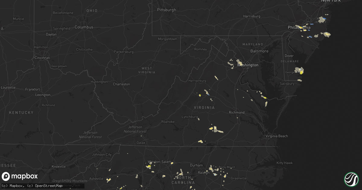
Hail Map in Virginia on August 19, 2019
Get this storm
August 19 map
$229
one time, instant access
Download today. No call, no setup
Keep the $229
Bought the map and want the full workflow? Apply the entire $229 to a subscription within 7 days. None of it is wasted.
Every map, not just this one
This buys you this map. Subscription and you get every map we run, in the markets you choose from a few cities to whole states to nationwide. Plus real-time alerts the moment a storm fires.
Contact data
Name, contact info, occupancy, even credit band for addresses in the footprint. You go from where it hit to who to call.
Become the source they trust
Unlimited branding weather history reports on demand. You already have the documented answer ready for the property owner, and you are the one who showed up with it.
Property data and RoofTrace estimates
Pull up any address you have got, its value and the exact code rules for that jurisdiction, straight from One Click Code. Then RoofTrace estimates the squares, pitch, and roof value, priced the way you price.
Storm reports in Virginia
Virginia
| Date | Description |
|---|---|
| 08/19/20196:58 PM CDT | Tree down on harmony church road near loudoun orchard road. |
| 08/19/20196:20 PM CDT | Trees down across lake monticello. Time estimated from radar. |
| 08/19/20195:56 PM CDT | Many trees reported down 4 n of kenbridge. Time estimated via radar. |
| 08/19/20195:53 PM CDT | Numerous trees down across northern lunenburg county. Many without power in victoria. Time estimated via radar. |
| 08/19/20195:50 PM CDT | Tree down reported at route 645 and cedar creek road. |
| 08/19/20195:23 PM CDT | Tree reported down on the 5300 block of ridge road. |
| 08/19/20195:22 PM CDT | Multiple trees reported down on ridge road near scuffletown. |
| 08/19/20195:22 PM CDT | Multiple trees reported down on tatums school road. |
| 08/19/20195:15 PM CDT | Several trees down across the extreme southeast part of the county impacting several roads... Such as wolftrap road... Coleman... And macdonald rd.... Etc.. |
| 08/19/20195:14 PM CDT | Tree reported down on the 13300 block of albano road. |
| 08/19/20195:06 PM CDT | Tree reported down on river oaks lane in the dunlora area of charlottesville. |
| 08/19/20195:05 PM CDT | Trees down on osborne turnpike. |
| 08/19/20195:00 PM CDT | Trees reported down on commonwealth drive. |
| 08/19/20195:00 PM CDT | Reports of structural damage to houses and potential gas leak along bay quarter dr. Time estimated from radar. |
| 08/19/20195:00 PM CDT | Large tree reported down blocking parts of four seasons drive in the rio area. |
| 08/19/20194:59 PM CDT | Reports of 2 trees down along bay quarter dr. Time estimated via radar. |
| 08/19/20194:58 PM CDT | Downed tree near greenbrier dr and rio rd |
| 08/19/20194:55 PM CDT | Quarter size hail reported along bay quarter drive. |
| 08/19/20194:55 PM CDT | Multiple downed trees across hydraulic rd |
| 08/19/20194:40 PM CDT | Large limbs and small trees down on power lines in powhatan. Some small hail also reported. |
| 08/19/20194:38 PM CDT | Tree reported down on sperryville pike near griffinsburg road. |
| 08/19/20194:20 PM CDT | A local report indicates 1.00 inch wind near 3 S GREENWOOD |
| 08/19/20194:10 PM CDT | Several limbs down along big river rd. |
| 08/19/20194:08 PM CDT | Large branches downed |
| 08/19/20194:04 PM CDT | Multiple trees reported down in the area of indian trail road near keezletown. |
| 08/19/20194:04 PM CDT | Multiple trees reported down in the mountain valley road area near keezletown. |
| 08/19/20193:51 PM CDT | Barn roof blown away near the intersection of route 11 and smithland rd |
| 08/19/20195:28 AM CDT | At 1028 PM EDT, a severe thunderstorm was located over Haymarket, or 9 miles southwest of South Riding, and is nearly stationary. HAZARD...60 mph wind gusts and quarter size hail. SOURCE...Radar indicated. IMPACT...Damaging winds will cause some trees and large branches to fall. This could injure those outdoors, as well as damage homes and vehicles. Roadways may become blocked by downed trees. Localized power outages are possible. Unsecured light objects may become projectiles. Locations impacted include... Linton Hall, Haymarket, Gainesville and Nokesville. |
| 08/19/20194:00 AM CDT | At 859 PM EDT, a severe thunderstorm was located near Middleburg, or 8 miles west of Brambleton, moving east at 15 mph. HAZARD...60 mph wind gusts. SOURCE...Radar indicated. IMPACT...Damaging winds will cause some trees and large branches to fall. This could injure those outdoors, as well as damage homes and vehicles. Roadways may become blocked by downed trees. Localized power outages are possible. Unsecured light objects may become projectiles. Locations impacted include... Middleburg and Aldie. |
| 08/19/20191:47 AM CDT | At 647 PM EDT, a severe thunderstorm was located near Kenbridge, moving west at 5 mph. HAZARD...60 mph wind gusts and quarter size hail. SOURCE...Radar indicated. IMPACT...Minor damage to vehicles is possible. Expect wind damage to trees and powerlines. This severe thunderstorm will be near, Victoria around 715 PM EDT.Other locations impacted by this severe thunderstorm include TheFalls. |
| 08/19/20191:37 AM CDT | At 636 PM EDT, a severe thunderstorm was located near Green Bay, or 7 miles east of Keysville, and is nearly stationary. HAZARD...60 mph wind gusts and quarter size hail. SOURCE...Radar indicated. IMPACT...Minor damage to vehicles is possible. Expect wind damage to trees and powerlines. Locations impacted include... Victoria, Lunenburg, Green Bay, Pleasant Grove, Arvins Store, Virso, Meherrin, Nutbush, Scholfield, Simplicity and Rubermount. |
| 08/19/20191:27 AM CDT | At 627 PM EDT, a severe thunderstorm was located near Fort Pickett, or near Blackstone, moving west at 5 mph. HAZARD...60 mph wind gusts and quarter size hail. SOURCE...Radar indicated. IMPACT...Minor damage to vehicles is possible. Expect wind damage to trees and powerlines. This severe thunderstorm will be near, Dundas around 650 PM EDT. Blackstone around 705 PM EDT. Kenbridge around 715 PM EDT.Other locations impacted by this severe thunderstorm include LafoonCorner, Ordsburg, Danieltown, Irby, Barrows Store, Murdocks andForkland. |
| 08/19/20191:21 AM CDT | At 620 PM EDT, severe thunderstorms were located along a line extending from 6 miles south of Madison to 10 miles southeast of Stanardsville, moving east at 10 mph. HAZARD...60 mph wind gusts. SOURCE...Radar indicated. IMPACT...Damaging winds will cause some trees and large branches to fall. This could injure those outdoors, as well as damage homes and vehicles. Roadways may become blocked by downed trees. Localized power outages are possible. Unsecured light objects may become projectiles. Locations impacted include... Orange, Gordonsville, Eheart, Barboursville, Madison Run, Montpelier Station, Rochelle, Aroda, Nasons, Madison Mills, Montford, Old Somerset, Twymans Mill and Somerset. |
| 08/19/201912:57 AM CDT | At 556 PM EDT, a severe thunderstorm was located over Charlottesville, moving southeast at 15 mph. HAZARD...60 mph wind gusts and quarter size hail. SOURCE...Radar indicated. IMPACT...Damaging winds will cause some trees and large branches to fall. This could injure those outdoors, as well as damage homes and vehicles. Roadways may become blocked by downed trees. Localized power outages are possible. Unsecured light objects may become projectiles. Locations impacted include... Charlottesville, Campbell, Westmoreland, Hollymead, Cismont, Newcomb Hall, Boyd Tavern, Monticello, Keswick, Flordon, Carrsbrook, Shadwell, Barracks and Scott Stadium. |
| 08/19/201912:50 AM CDT | At 550 PM EDT, a severe thunderstorm was located over Dryburg, moving west at 5 mph. HAZARD...60 mph wind gusts and quarter size hail. SOURCE...Radar indicated. IMPACT...Hail damage to vehicles is expected. Expect wind damage to roofs, siding, and trees. Locations impacted include... Redoak... Scottsburg... Staunton River State Park... and Dryburg. |
| 08/19/201912:47 AM CDT | At 547 PM EDT, severe thunderstorms were located along a line extending from Meadowville to Centralia, and are nearly stationary. HAZARD...60 mph wind gusts and quarter size hail. SOURCE...Radar indicated. IMPACT...Minor damage to vehicles is possible. Expect wind damage to trees and powerlines. Locations impacted include... Chester, Bellwood, Meadowville and Centralia. |
| 08/19/201912:33 AM CDT | At 532 PM EDT, a severe thunderstorm was located over Free Union, or 10 miles northwest of Charlottesville, moving southeast at 10 mph. HAZARD...60 mph wind gusts and quarter size hail. SOURCE...Radar indicated. IMPACT...Damaging winds will cause some trees and large branches to fall. This could injure those outdoors, as well as damage homes and vehicles. Roadways may become blocked by downed trees. Localized power outages are possible. Unsecured light objects may become projectiles. Locations impacted include... Charlottesville, Free Union, Westmoreland, Hollymead, Advance Mills, Carrsbrook and Earlysville. |
| 08/19/201912:14 AM CDT | At 514 PM EDT, a severe thunderstorm was located 7 miles southeast of Sperryville, or 11 miles northwest of Culpeper, moving southeast at 10 mph. HAZARD...60 mph wind gusts. SOURCE...Radar indicated. IMPACT...Damaging winds will cause some trees and large branches to fall. This could injure those outdoors, as well as damage homes and vehicles. Roadways may become blocked by downed trees. Localized power outages are possible. Unsecured light objects may become projectiles. Locations impacted include... Reva, Slate Mills, Cardova, Boston and Woodville. |
| 08/19/201912:07 AM CDT | At 507 PM EDT, a severe thunderstorm was located over Crozet, or 9 miles east of Waynesboro, moving east at 5 mph. HAZARD...60 mph wind gusts. SOURCE...Radar indicated. IMPACT...Damaging winds will cause some trees and large branches to fall. This could injure those outdoors, as well as damage homes and vehicles. Roadways may become blocked by downed trees. Localized power outages are possible. Unsecured light objects may become projectiles. Locations impacted include... Crozet, Ivy, Yancey Mills, Greenwood and Batesville. |
| 08/19/201912:02 AM CDT | At 501 PM EDT, a severe thunderstorm was located over Massanutten, or east of Harrisonburg, moving east at 15 mph. HAZARD...60 mph wind gusts. SOURCE...Radar indicated. IMPACT...Damaging winds will cause some trees and large branches to fall. This could injure those outdoors, as well as damage homes and vehicles. Roadways may become blocked by downed trees. Localized power outages are possible. Unsecured light objects may become projectiles. Locations impacted include... Massanutten, Elkton, Rocky Bar, Penn Laird, Swift Run, Keezletown and Mcgaheysville. |
| 08/18/201911:36 PM CDT | At 435 PM EDT, a severe thunderstorm was located over Kempsville, and is nearly stationary. HAZARD...60 mph wind gusts and quarter size hail. SOURCE...Radar indicated. IMPACT...Minor damage to vehicles is possible. Expect wind damage to trees and powerlines. This severe thunderstorm will remain over mainly rural areas of the northwestern City of Virginia Beach, including the following locations... Gallups Corner, Princess Anne Plaza and London Bridge. |
| 08/18/201910:18 PM CDT | At 318 PM EDT, a severe thunderstorm was located near Ivanhoe, and is nearly stationary. HAZARD...60 mph wind gusts and quarter size hail. SOURCE...Radar indicated. IMPACT...Hail damage to vehicles is expected. Expect wind damage to roofs, siding, and trees. Locations impacted include... Patterson... Grahams Forge... Ivanhoe... Sylvatus... and Fort Chiswell. |
| 08/18/20199:59 PM CDT | Tree down on us 50 at cedar lane |
| 08/18/20199:49 PM CDT | Tree down on sudley road at gum springs road |
| 08/18/20198:12 PM CDT | One large white oak tree blown down near a church along rocks chruch road. |
| 08/18/20198:09 PM CDT | Tree reported down on braddick road near lacys tavern court. |
| 08/18/20197:47 PM CDT | A possible microburst blew down several trees... Power lines... And poles down near the intersection of fleshman street and annie street. In addition... The winds flipp |
All States Impacted by Hail Map on August 19, 2019
Cities Impacted by Hail Map on August 19, 2019
- Afton, VA
- Greenwood, VA
- Bryson City, NC
- Scottsburg, VA
- Virgilina, VA
- Royston, GA
- Greensboro, NC
- Charlottesville, VA
- Earlysville, VA
- Free Union, VA
- Crozet, VA
- Humboldt, IA
- Hardy, IA
- Dickinson, ND
- Belfield, ND
- Fairfield, ND
- Pennsauken, NJ
- Cherry Hill, NJ
- Merchantville, NJ
- Camden, NJ
- Oberlin, KS
- Sperryville, VA
- Frankville, AL
- Millry, AL
- Chatom, AL
- Sherburn, MN
- Lee, NH
- Georgetown, MN
- Sainte Genevieve, MO
- Farmington, MO
- Hardaway, AL
- Tuskegee, AL
- Charlotte, NC
- Knightdale, NC
- Raleigh, NC
- Goldsboro, NC
- Lewes, DE
- Ramseur, NC
- Liberty, NC
- Staley, NC
- Perley, MN
- Borup, MN
- Hartwell, GA
- Oakton, VA
- Reston, VA
- Vienna, VA
- Devils Lake, ND
- Leeds, ND
- Argusville, ND
- Canton, GA
- Knoxville, AL
- Keystone, IA
- Elberon, IA
- Patoka, IL
- Verndale, MN
- Rehoboth Beach, DE
- Cove City, NC
- Old Fort, NC
- Springfield, MA
- Longmeadow, MA
- Feeding Hills, MA
- Agawam, MA
- Southwick, MA
- Kinston, NC
- Adairsville, GA
- Calhoun, GA
- Jeffers, MN
- Sanborn, MN
- Decatur, AL
- Eastchester, NY
- Tuckahoe, NY
- New Rochelle, NY
- Tuttle, ND
- Wannaska, MN
- Marion, NC
- Easley, SC
- Marshville, NC
- Peachland, NC
- Toledo, IA
- Dysart, IA
- Luzerne, IA
- Belle Plaine, IA
- Clutier, IA
- Geraldine, AL
- Liberty, SC
- Iowa City, IA
- Lone Tree, IA
- Riverside, IA
- Hills, IA
- Fairmont, MN
- Staples, MN
- Aldrich, MN
- Bertha, MN
- Trappe, MD
- Marion, AL
- Philadelphia, PA
- Vredenburgh, AL
- Franklin, AL
- Sterrett, AL
- Vincent, AL
- Woden, IA
- Britt, IA
- Titonka, IA
- Wesley, IA
- Vernon, CO
- Wray, CO
- Pell City, AL
- Vandiver, AL
- Fairmount, GA
- Manning, ND
- Barnegat, NJ
- Beach Haven, NJ
- Waretown, NJ
- Barnegat Light, NJ
- Belleville, IL
- Scott Air Force Base, IL
- O'Fallon, IL
- Freeburg, IL
- Mascoutah, IL
- West Springfield, MA
- Westfield, MA
- East Longmeadow, MA
- Hampden, MA
- Holly, CO
- Blanchard, ND
- Hatton, ND
- Mayville, ND
- Portland, ND
- Northwood, ND
- Windom, MN
- Fenton, IA
- Hendrum, MN
- Harwood, ND
- Gardner, ND
- Ada, MN
- Hobson, MT
- Trimont, MN
- Plains, KS
- Meade, KS
- Cleveland, GA
- Sautee Nacoochee, GA
- Montross, VA
- Pekin, ND
- Petersburg, ND
- Tolna, ND
- Niagara, ND
- Minnewaukan, ND
- Mcville, ND
- Penn, ND
- Churchs Ferry, ND
- Crary, ND
- Aneta, ND
- Larimore, ND
- Lakota, ND
- Michigan, ND
- York, ND
- Seneca, SC
- Woodville, MS
- Saint Stephens, AL
- Rome, GA
- Livermore, IA
- Lu Verne, IA
- Athens, GA
- Watkinsville, GA
- Bogart, GA
- Meherrin, VA
- Rugby, ND
- Georgetown, DE
- Harbeson, DE
- Milton, DE
- Freehold, NJ
- Jefferson, GA
- Summerville, GA
- Scottsville, VA
- Palmyra, VA
- Belchertown, MA
- Algona, IA
- Graettinger, IA
- Bancroft, IA
- Burt, IA
- Cylinder, IA
- Whittemore, IA
- Emmetsburg, IA
- Lone Rock, IA
- Stafford Springs, CT
- Mountain Lake, MN
- Bingham Lake, MN
- Livermore, ME
- Newbern, AL
- Kensett, IA
- Wilton, CT
- New Canaan, CT
- Denton, NC
- Lexington, NC
- Cuthbert, GA
- Chapin, SC
- Little Mountain, SC
- Louisburg, NC
- Cameron, NC
- Sanford, NC
- Section, AL
- Dutton, AL
- Nashua, IA
- Thor, IA
- Badger, IA
- Cumming, GA
- Alpharetta, GA
- Union Mills, NC
- Lake Lure, NC
- Fairfax, IA
- Amana, IA
- Herndon, KS
- Perham, MN
- New York Mills, MN
- Mocksville, NC
- Harmony, NC
- Ringsted, IA
- Wallingford, IA
- Estherville, IA
- Lookout Mountain, GA
- Flintstone, GA
- Menahga, MN
- Newhall, IA
- Watkins, IA
- Lesterville, MO
- Amherst, MA
- Buffalo Junction, VA
- South Boston, VA
- Fayette, AL
- Rutland, IA
- Dakota City, IA
- Eagle Grove, IA
- Goldfield, IA
- Sterling, VA
- McLean, VA
- Dunn Loring, VA
- Falls Church, VA
- Herndon, VA
- Great Falls, VA
- Frazee, MN
- Sebeka, MN
- Keysville, VA
- Green Bay, VA
- Wade, NC
- Linden, NC
- Corwith, IA
- Renwick, IA
- Upper Marlboro, MD
- Moorestown, NJ
- Riverton, NJ
- Maple Shade, NJ
- Wingate, NC
- Monroe, NC
- Marlton, NJ
- Voorhees, NJ
- Gary, MN
- Twin Valley, MN
- Terril, IA
- Pisgah Forest, NC
- Penrose, NC
- Brierfield, AL
- Greenville, IL
- Springfield, MN
- Comfrey, MN
- McCalla, AL
- Birmingham, AL
- Bessemer, AL
- Helena, AL
- Turpin, OK
- Milford, VA
- Walnut Hill, IL
- Centralia, IL
- Yadkinville, NC
- Clare, IA
- Starr, SC
- Iva, SC
- Traer, IA
- Piney Point, MD
- Heathsville, VA
- Northport, AL
- Berry, AL
- Kinards, SC
- Lancaster, MN
- Dewy Rose, GA
- Towner, ND
- Northwood, IA
- Lake Mills, IA
- Badger, MN
- Greenwich, CT
- Nisswa, MN
- Pine River, MN
- Pequot Lakes, MN
- Cushing, MN
- Pillager, MN
- Brainerd, MN
- Motley, MN
- Perryton, TX
- Victoria, VA
- Ackley, IA
- Iowa Falls, IA
- Alden, IA
- Lyerly, GA
- Winnebago, MN
- Delavan, MN
- Storden, MN
- Zebulon, NC
- Middlesex, NC
- Laurens, SC
- Mountville, SC
- Waterloo, SC
- Chicopee, MA
- Oconee, IL
- Lusby, MD
- Birch Tree, MO
- Kenbridge, VA
- Odin, IL
- Sandoval, IL
- Mulberry Grove, IL
- Keyesport, IL
- Carlyle, IL
- Vandalia, IL
- Smithboro, IL
- Hillsboro, ND
- Marengo, IA
- Newberry, SC
- Silverstreet, SC
- Jackson, MN
- Cheltenham, PA
- Merion Station, PA
- Wynnewood, PA
- Norway, IA
- Kenly, NC
- Sims, NC
- Chelsea, IA
- Walsh, CO
- Chantilly, VA
- Catharpin, VA
- Fort Dodge, IA
- Gilmore City, IA
- Vincent, IA
- Spirit Lake, IA
- Dolliver, IA
- Mars Hill, NC
- Buffalo Center, IA
- Thompson, IA
- Dunnell, MN
- Boston, VA
- Groveoak, AL
- West Jefferson, NC
- Bryant Pond, ME
- Hanlontown, IA
- Joice, IA
- Greenbush, MN
- Fayetteville, NC
- Travelers Rest, SC
- Taylors, SC
- Greer, SC
- Marietta, SC
- Trenton, IL
- Aviston, IL
- Highland, IL
- Leland, IA
- Millstone Township, NJ
- Cream Ridge, NJ
- Englishtown, NJ
- Jackson, NJ
- Howell, NJ
- Spring Hope, NC
- Elm City, NC
- Wilson, NC
- Lena, LA
- Flatwoods, LA
- Beaver City, NE
- Hendley, NE
- Pendleton, SC
- Teutopolis, IL
- Kodak, TN
- Sevierville, TN
- Armuchee, GA
- Kingston, OH
- Circleville, OH
- Snow Camp, NC
- Siler City, NC
- Adams, ND
- Spring Lake, NC
- Burkeville, VA
- Avoca, MN
- Gaylesville, AL
- Central, SC
- Fremont, NC
- Pikeville, NC
- Winder, GA
- Reva, VA
- Wendell, NC
- Robinson, ND
- Ninety Six, SC
- Chappells, SC
- Bailey, NC
- Montgomery, AL
- Baxter, MN
- Pocahontas, IL
- Fairdale, ND
- Millstadt, IL
- Smithton, IL
- Wing, ND
- Epping, NH
- Eutaw, AL
- Scarsdale, NY
- Mount Vernon, NY
- Larchmont, NY
- Pelham, NY
- Bronxville, NY
- Yonkers, NY
- Mamaroneck, NY
- Youngsville, NC
- Wake Forest, NC
- Rolesville, NC
- West Union, SC
- Walhalla, SC
- Westminster, SC
- Gladbrook, IA
- Eatontown, NJ
- Colts Neck, NJ
- Trion, GA
- Aldie, VA
- Middleburg, VA
- Leesburg, VA
- Gray Court, SC
- Morganton, NC
- Heron Lake, MN
- Monson, MA
- West Suffield, CT
- Trenton, NC
- Dover, NC
- Huntersville, NC
- Culpeper, VA
- Rocky Mount, NC
- Tarboro, NC
- Pollock, LA
- Welcome, MN
- Blair, SC
- Wadena, MN
- Ceylon, MN
- Lancaster, VA
- Weems, VA
- Kilmarnock, VA
- Caledonia, ND
- Blackstone, VA
- Hampden, ND
- Glassboro, NJ
- Sewell, NJ
- Williamstown, NJ
- Leeds, ME
- Hamptonville, NC
- Forest City, NC
- Ellenboro, NC
- Mooresboro, NC
- Clemson, SC
- Willingboro, NJ
- Burlington, NJ
- Vernon, AL
- Sulligent, AL
- Shelby, NC
- Osage, MN
- Detroit Lakes, MN
- Wheatland, ND
- Casselton, ND
- Saint Peter, IL
- Ware, MA
- Wilbraham, MA
- Wales, MA
- Stewardson, IL
- Shumway, IL
- Plainville, GA
- Effingham, IL
- Dundas, VA
- Cedar Rapids, IA
- Clarksville, VA
- Runnemede, NJ
- Hague, VA
- Chesnee, SC
- Indian Orchard, MA
- Ludlow, MA
- Greenwood, ME
- Radcliffe, IA
- Ellsworth, IA
- Munich, ND
- Ellington, MO
- Kennedy, AL
- Millport, AL
- Seaside Park, NJ
- Forked River, NJ
- Talking Rock, GA
- Jasper, GA
- Ulen, MN
- Waubun, MN
- Spruce Pine, NC
- Moundville, AL
- Milford, IA
- Mchenry, ND
- Durham, NH
- Linton, IN
- Fairview Heights, IL
- Lebanon, IL
- Waterloo, IL
- Robbins, NC
- Nashville, NC
- Van Horne, IA
- Garrison, IA
- Garwin, IA
- Reinbeck, IA
- Hudson, IA
- Buckingham, IA
- Hubbard, IA
- Grace City, ND
- Catawba, NC
- Claremont, NC
- Westport, CT
- Weston, CT
- Fairfield, CT
- Plant City, FL
- Bunnlevel, NC
- Hammonton, NJ
- Thomaston, AL
- Uniontown, AL
- Redding, CT
- Easton, CT
- Idalia, CO
- Chatsworth, NJ
- Vincentown, NJ
- Turner, ME
- Buckfield, ME
- Ironton, MO
- Rockwell, IA
- Felton, MN
- Grandin, ND
- Ogema, MN
- Arthur, ND
- Selbyville, DE
- Alberta, VA
- Tappahannock, VA
- Haymarket, VA
- Andrews, NC
- Bala Cynwyd, PA
- Narberth, PA
- Havertown, PA
- Collingswood, NJ
- Ardmore, PA
- Statesville, NC
- Newton, NC
- Appomattox, VA
- Orlando, FL
- Windermere, FL
- Wayne, ME
- Mount Kisco, NY
- Armonk, NY
- Gaffney, SC
- Augusta, ME
- Kinsale, VA
- West Paris, ME
- Dawsonville, GA
- Marshall, MN
- Cottonwood, MN
- Cave Spring, GA
- Swea City, IA
- Carlisle, SC
- Woolstock, IA
- Ocean City, MD
- Haddonfield, NJ
- Anderson, SC
- Scotland, MD
- Glendora, NJ
- Woodbury, NJ
- Bellmawr, NJ
- Westville, NJ
- Barrington, NJ
- Westbrook, MN
- Butterfield, MN
- Lamberton, MN
- Stantonsburg, NC
- Saint James, MN
- Alma, IL
- Frankford, DE
- Bishopville, MD
- Pittsboro, NC
- Knoxville, TN
- Dix, IL
- Mount Vernon, IL
- Readfield, ME
- Manchester, ME
- Winthrop, ME
- Bennett, NC
- Coffeeville, AL
- Highlands, NC
- Ruckersville, VA
- Pickens, SC
- Hodges, SC
- Pope Army Airfield, NC
- Fort Bragg, NC
- Colonial Beach, VA
- The Plains, VA
- Waleska, GA
- Woodford, VA
- Deep Run, NC
- Lottsburg, VA
- Callao, VA
- Caseyville, IL
- Collinsville, IL
- Troy, IL
- Gainesville, GA
- Athens, AL
- Tanner, AL
- Gainesville, VA
- Bristow, VA
- Manassas, VA
- Greenwood, SC
- Bode, IA
- Ruthven, IA
- Okoboji, IA
- Armstrong, IA
- Arnolds Park, IA
- West Bend, IA
- Beecher City, IL
- Alpha, MN
- Darfur, MN
- Fulda, MN
- Waynesboro, VA
- Lewisville, NC
- Clemmons, NC
- Edmore, ND
- Melbourne, AR
- Lawndale, NC
- Lakota, IA
- Buckatunna, MS
- State Line, MS
- Derry, NH
- Austinville, VA
- Max Meadows, VA
- Chickamauga, GA
- Akron, AL
- Annapolis, MO
- Vulcan, MO
- Forgan, OK
- Advance, NC
- Union Springs, AL
- Browerville, MN
- Hewitt, MN
- Bluffton, MN
- Hatchechubbee, AL
- Madison, GA
- Chester, VA
- Richmond, VA
- Asheboro, NC
- Seagrove, NC
- New Straitsville, OH
- Suffield, CT
- Mahnomen, MN
- Callaway, MN
- Park Rapids, MN
- Walker, MN
- Rochert, MN
- White Earth, MN
- Ponsford, MN
- Laporte, MN
- Hackensack, MN
- Naytahwaush, MN
- Lake George, MN
- Backus, MN
- Nevis, MN
- Bagley, MN
- Akeley, MN
- Fosston, MN
- Bejou, MN
- Fort Ripley, MN
- Lookout Mountain, TN
- Remsen, IA
- Marcus, IA
- Clarion, IA
- Gray, IA
- Templeton, IA
- Audubon, IA
- Kirkman, IA
- Defiance, IA
- Harlan, IA
- Manning, IA
- Manilla, IA
- Irwin, IA
- Auburn, IA
- Lytton, IA
- Lake City, IA
- Vail, IA
- Breda, IA
- Westside, IA
- Carroll, IA
- Rockwell City, IA
- Arcadia, IA
- Quimby, IA
- Cherokee, IA
- Cleghorn, IA
- Scranton, IA
- Glidden, IA
- Ralston, IA
- Coon Rapids, IA
- Earlham, IA
- Van Meter, IA
- Winterset, IA
- Uxbridge, MA
- Slatersville, RI
- Harrisville, RI
- Douglas, MA
- Webster, MA
- Dudley, MA
- North Smithfield, RI
- North Grosvenordale, CT
- Pascoag, RI
- Thompson, CT
- Plainville, MA
- Attleboro Falls, MA
- North Attleboro, MA
- Grass Range, MT
- Lewistown, MT
- Gloucester City, NJ
- Bordentown, NJ
- Columbus, NJ
- Jobstown, NJ
- Wrightstown, NJ
- Medford, NJ
- Farmingdale, NJ
- Waterford Works, NJ
- Knox, ND
- Wolford, ND
- Bowdon, ND
- Buxton, ND
- Strawberry Plains, TN
- Hornick, IA
- Smithland, IA
- Earling, IA
- Panama, IA
- Westphalia, IA
- Danbury, IA
- Anthon, IA
- Battle Creek, IA
- Oto, IA
- Holstein, IA
- Cushing, IA
- Galva, IA
- Washta, IA
- Correctionville, IA
- Kimballton, IA
- Chillicothe, IA
- Milo, IA
- What Cheer, IA
- Packwood, IA
- Ackworth, IA
- Sigourney, IA
- Eldon, IA
- Ollie, IA
- Floris, IA
- Saint Charles, IA
- Melcher Dallas, IA
- Chariton, IA
- New Sharon, IA
- Hayesville, IA
- Eddyville, IA
- Hedrick, IA
- Martensdale, IA
- Cumming, IA
- Udell, IA
- University Park, IA
- Prole, IA
- Lacona, IA
- Agency, IA
- Fairfield, IA
- Williamson, IA
- Indianola, IA
- Bussey, IA
- Pleasantville, IA
- Tracy, IA
- Rose Hill, IA
- Norwalk, IA
- Drakesville, IA
- Woodburn, IA
- Unionville, IA
- Osceola, IA
- Hamilton, IA
- Moravia, IA
- Liberty Center, IA
- Batavia, IA
- Fremont, IA
- New Virginia, IA
- Blakesburg, IA
- Russell, IA
- Bloomfield, IA
- Leighton, IA
- Melrose, IA
- Albia, IA
- Martinsburg, IA
- Bevington, IA
- Beacon, IA
- Cedar, IA
- Knoxville, IA
- Lovilia, IA
- Saint Marys, IA
- Lucas, IA
- Kirkville, IA
- Delta, IA
- Centerville, IA
- Richland, IA
- Oskaloosa, IA
- Ottumwa, IA
- Columbia, IA
- Cambridge, IA
- Maxwell, IA
- Mingo, IA
- Collins, IA
- Adair, IA
- Casey, IA
- Stuart, IA
- Exira, IA
- Redfield, IA
- Menlo, IA
- Panora, IA
- Dexter, IA
- Adel, IA
- Guthrie Center, IA
- Hamlin, IA
- Linden, IA
- West Des Moines, IA
- Berwick, IA
- Johnston, IA
- Mitchellville, IA
- Newton, IA
- Prairie City, IA
- Otley, IA
- Reasnor, IA
- Swan, IA
- Altoona, IA
- Lynnville, IA
- Des Moines, IA
- Killduff, IA
- Carlisle, IA
- Harvey, IA
- Sully, IA
- Runnells, IA
- Elkhart, IA
- Montezuma, IA
- Bondurant, IA
- Hartford, IA
- Pleasant Hill, IA
- Ankeny, IA
- Searsboro, IA
- Monroe, IA
- Grinnell, IA
- Urbandale, IA
- Pella, IA
- Colfax, IA
- Tuscaloosa, AL
- Bantry, ND
- Brocket, ND
- Southport, CT
- Bridgeport, CT
- White Oak, NC
- Madbury, NH
- Nottingham, NH
- Dover, NH
- Elkhart, KS


