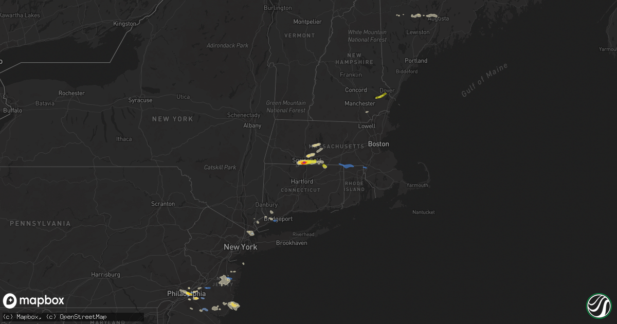
Hail Map on August 19, 2019
Get this storm
August 19 map
$229
one time, instant access
Download today. No call, no setup
Keep the $229
Bought the map and want the full workflow? Apply the entire $229 to a subscription within 7 days. None of it is wasted.
Every map, not just this one
This buys you this map. Subscription and you get every map we run, in the markets you choose from a few cities to whole states to nationwide. Plus real-time alerts the moment a storm fires.
Contact data
Name, contact info, occupancy, even credit band for addresses in the footprint. You go from where it hit to who to call.
Become the source they trust
Unlimited branding weather history reports on demand. You already have the documented answer ready for the property owner, and you are the one who showed up with it.
Property data and RoofTrace estimates
Pull up any address you have got, its value and the exact code rules for that jurisdiction, straight from One Click Code. Then RoofTrace estimates the squares, pitch, and roof value, priced the way you price.
States Impacted by Hail Map on August 19, 2019
Storm reports
Alabama
| Date | Description |
|---|---|
| 08/19/20196:46 PM CDT | Trees and power lines down near hwy 480 and hwy 50. Time estimated by radar. |
| 08/19/20196:46 PM CDT | Trees and power lines down. Time estimated by radar. |
| 08/19/20196:45 PM CDT | Tree reported down at 400 alexander road. Time estimated by radar. |
| 08/19/20196:45 PM CDT | Tree down on home in lipscomb. Time estimated by radar. |
| 08/19/20196:41 PM CDT | Trees down along hwy 55 ... Northeast of sterrett... Al. Time estimated by radar. |
| 08/19/20196:17 PM CDT | Corrects previous tstm wnd dmg report from 5 n columbiana. Trees and power lines down near chelsea rd and foster rd. Time estimated by radar and arrival of gust front. |
| 08/19/20196:11 PM CDT | Corrects previous tstm wnd dmg report from 1 s highland lakes. Tree reported down at 299 linwood road. Time estimated by radar. |
| 08/19/20196:03 PM CDT | Corrects previous tstm wnd dmg report from mount laurel. Numerous trees down along hwy 41 near stonegate drive and connemara trail area. Time estimated by radar. |
| 08/19/20195:58 PM CDT | Corrects previous tstm wnd dmg report from 3 e shoal creek golf club. Trees and power lines down along bear creek road. Time estimated by radar. |
| 08/19/20195:55 PM CDT | Ema reports trees down within decatur city limits. |
| 08/19/20195:46 PM CDT | Corrects previous tstm wnd dmg report from 1 nne vandiver. Trees and power lines down near hwy 480 and hwy 50. Time estimated by radar. |
| 08/19/20195:46 PM CDT | Corrects previous tstm wnd dmg report from 3 nne wehapa lake. Trees and power lines down. Time estimated by radar. |
| 08/19/20195:45 PM CDT | Corrects previous tstm wnd dmg report from 2 n vandiver. Tree reported down at 400 alexander road. Time estimated by radar. |
| 08/19/20195:41 PM CDT | Corrects previous tstm wnd dmg report from 3 nne sterrett. Trees down along hwy 55 ... Northeast of sterrett... Al. Time estimated by radar. |
| 08/19/20195:35 PM CDT | Roof and minor structural damage was reported at two neighboring farm buildings on county rd 47. Time estimated by radar. |
| 08/19/20195:30 PM CDT | Trees down on hwy 331 in montgomery. Fire station had minor roof damage. Time estimated. Winds estimated 40-50mph. |
| 08/19/20194:06 PM CDT | Trees were blown down and a roof was blown off a mobile home along shiver de freeze road in far northern tuscaloosa county. |
| 08/19/20193:11 PM CDT | A tree has fallen on a home on 6th ave nw. The home was also hit by lightning. Winds estimated at 50 mph. |
| 08/19/20193:10 PM CDT | A roof was blown off a building on cleveland ave. Winds estimated at 50 mph. |
| 08/19/20193:08 PM CDT | A large tree was blown down near mcdonalds on chestnut in attalla. Winds estimated at 50 mph. |
| 08/19/20193:06 PM CDT | A large tree and power lines were downed near chestnut and cleveland. Winds estimated at 45 mph. |
| 08/19/20193:00 PM CDT | A tree was blown down and into the roadway on cr 52 north of weiss lake. |
| 08/19/20191:42 PM CDT | Several trees were blown down along highway 5 northeast of marion. |
| 08/19/20191:37 PM CDT | Corrects previous tstm wnd dmg report from 3 ssw heiberger. Several trees were blown down along cr 16. Time estimated by radar. |
| 08/19/20191:30 PM CDT | Several trees were blown down along cr 16. |
| 08/19/20191:29 PM CDT | A tree was knocked down onto a residence in pine ridge. |
| 08/19/20191:06 PM CDT | Several trees down onto cr 156 in the section area. Time estimated by radar. |
| 08/19/201912:24 AM CDT | At 523 PM CDT, a severe thunderstorm was located over southwestern Montgomery, and is nearly stationary. HAZARD...60 mph wind gusts and penny size hail. SOURCE...Radar indicated. IMPACT...Expect damage to roofs, siding, and trees. Locations impacted include... Montgomery, Hunter, Dannelly Field, Maxwell Air Force Base, Snowdoun, Hyundai Motors Of Alabama, Alabama State University, Montgomery Riverwalk Stadium, Pinedale, Hope Hull, Woodcrest and Alabama State Capitol. |
| 08/19/201912:12 AM CDT | At 512 PM CDT, a severe thunderstorm was located near Hardaway, or 10 miles northwest of Union Springs, and is nearly stationary. HAZARD...60 mph wind gusts and penny size hail. SOURCE...Radar indicated. IMPACT...Expect damage to roofs, siding, and trees. Locations impacted include... Hardaway, Liverpool, Cross Keys and Fort Davis. |
| 08/19/201912:09 AM CDT | At 509 PM CDT, a severe thunderstorm was located 6 miles north of Chatom, moving west at 15 mph. HAZARD...60 mph wind gusts and penny size hail. SOURCE...Radar indicated. IMPACT...Expect damage to roofs, siding, and trees. Locations impacted include... Chatom, Saint Stephens, Wagarville and Millry. |
| 08/18/201911:51 PM CDT | At 451 PM CDT, a severe thunderstorm was located 5 miles northwest of Saint Stephens, or 10 miles northeast of Chatom, and is nearly stationary. HAZARD...60 mph wind gusts and penny size hail. SOURCE...Radar indicated. IMPACT...Expect damage to roofs, siding, and trees. Locations impacted include... Saint Stephens and Leroy. |
| 08/18/20199:55 PM CDT | At 255 PM CDT, a severe thunderstorm was located over Dothan, moving southwest at 15 mph. HAZARD...60 mph wind gusts and penny size hail. SOURCE...Radar indicated. IMPACT...Expect damage to roofs, siding, and trees. Locations impacted include... Dothan, Headland, Taylor, Midland City, Kinsey, Ashford, Slocomb, Cowarts, Newton, Webb, Pinckard, Malvern, Rehobeth, Grimes, Avon, Napier Field, Memphis, Hollis Dairy Road, Enon and Wilson Mill. |
| 08/18/20198:36 PM CDT | At 136 PM CDT, a severe thunderstorm was located near Marion, moving southwest at 20 mph. HAZARD...60 mph wind gusts and quarter size hail. SOURCE...Radar indicated. IMPACT...Hail damage to vehicles is expected. Expect wind damage to roofs, siding, and trees. Locations impacted include... Marion, Heiberger, Sprott, Folsom and Judson College. |
| 08/18/20198:14 PM CDT | At 114 PM CDT, a severe thunderstorm was located near Powell, or 8 miles north of Rainsville, moving northeast at 10 mph. HAZARD...60 mph wind gusts and quarter size hail. SOURCE...Radar indicated. IMPACT...Hail damage to vehicles is expected. Expect wind damage to roofs, siding, and trees. Locations impacted include... Scottsboro, Rainsville, Henagar, Sylvania, Powell, Section, Pisgah and Dutton. |
| 08/18/20197:15 PM CDT | Tree reported down at 299 linwood road. Time estimated by radar. |
| 08/18/20197:08 PM CDT | Trees and power lines down near chelsea rd and foster rd. Time estimated by radar and arrival of gust front. Winds estimated 40mph. |
| 08/18/20197:00 PM CDT | Trees and power lines down along bear creek road. Time estimated by radar. |
| 08/18/20197:00 PM CDT | Numerous trees and power lines down in bessemer. Time estimated by radar. |
| 08/18/20197:00 PM CDT | Numerous trees down along hwy 41 near stonegate drive and connemara trail area. Time estimated by radar. |
Connecticut
| Date | Description |
|---|---|
| 08/19/20195:05 PM CDT | Tree and powerlines down along route 1 between west wharf road and island ave. |
| 08/19/20195:00 PM CDT | Large tree branch and powerlines down along route 1 near longshore road |
| 08/19/20194:52 PM CDT | Pine tree snapped on east river road near the madison town line. |
| 08/19/20194:45 PM CDT | Tree branch down along route 1 before horseshoe road. Branch is blocking road. |
| 08/19/20193:55 PM CDT | Large branch down on i-95 southbound at exit 24 in fairfield. |
| 08/19/20193:49 PM CDT | Tree leaning across the road on wires on judd road. Trees down on both sides of the bridge on parker bridge road. Live wires in tree on depot road at the town line. Eve |
| 08/19/20193:49 PM CDT | Live wires in tree on lakeview drive at hilltop drive. Event time radar estimated. |
| 08/19/20193:49 PM CDT | Live wires in tree on flanders road in coventry ri. Event time radar estimated. |
| 08/19/20193:47 PM CDT | Tree down blocking weston road between cross highway and easton road in westport. |
| 08/19/20193:30 PM CDT | Trees felled by wind across town. |
| 08/19/20192:50 PM CDT | Trees and primary lines down on hagstrom road in woodstock... Ct. |
| 08/19/20192:40 PM CDT | Trees and primary wires down |
| 08/19/201912:00 AM CDT | At 500 PM EDT, a severe thunderstorm was located near Bridgeport, moving east at 40 mph. HAZARD...60 mph wind gusts. SOURCE...Radar indicated. IMPACT...Expect damage to trees and power lines. Locations impacted include... Bridgeport, Fairfield and Stratford. |
| 08/18/201910:45 PM CDT | At 344 PM EDT, a severe thunderstorm was located over Webster, or 17 miles south of Worcester, moving east at 30 mph. HAZARD...60 mph wind gusts and penny size hail. SOURCE...Radar indicated. IMPACT...Expect damage to trees and power lines. Locations impacted include... Pawtucket, Woonsocket, Cumberland, North Providence, Franklin, North Attleborough, Attleboro, Walpole, Smithfield, Lincoln, Central Falls, Sharon, Foxborough, Webster, Bellingham, Burrillville, Northbridge, Oxford, Uxbridge and North Smithfield. |
| 08/18/20199:56 PM CDT | At 255 PM EDT, a severe thunderstorm was located over Hampden, or 7 miles east of Springfield, moving east at 30 mph. HAZARD...60 mph wind gusts and quarter size hail. SOURCE...Radar indicated. IMPACT...Expect damage to trees and power lines. Hail damage to vehicles is possible. Locations impacted include... Worcester, Springfield, Ludlow, Holden, Webster, Southbridge, Auburn, East Longmeadow, Belchertown, Wilbraham, Oxford, Charlton, Palmer, Stafford, Spencer, Somers, Dudley, Leicester, Ware and Thompson. |
New Jersey
| Date | Description |
|---|---|
| 08/19/20194:00 PM CDT | Delayed report. Barn blown over... Some tree damage and a large farm irrigation system blown over on spring road. Time estimated from radar. |
| 08/19/20193:38 PM CDT | Tree branches and power poles downed in the medford area according to mping. Time estimated from radar. |
| 08/19/20193:37 PM CDT | Tree down in wires with power outages near grassmere avenue and chestnut avenue. Time estimated from radar. |
| 08/19/20193:34 PM CDT | Mping report of large tree limbs snapped and power poles broken. Time estimated from radar. |
| 08/19/20193:24 PM CDT | Downed trees and wires near old farm road and sycamore avenue. Time estimated from radar. |
| 08/19/20193:20 PM CDT | A local report indicates 1.50 inch wind near 1 N ELLISBURG |
| 08/19/20193:14 PM CDT | Spotter estimated 50 kt wind gusts with storm passage. |
| 08/19/20193:13 PM CDT | Wind gusts between 61 and 73 mph. Time estimated from radar. |
| 08/19/20193:13 PM CDT | Downed trees and power lines near woodland avenue and linden avenue. Time estimated from radar. |
| 08/19/20193:13 PM CDT | Multiple trees down with street closures from pennsauken to the cherry hill mall. Power outages in this area... Which are leading to traffic disruptions as well. Time e |
| 08/19/20193:12 PM CDT | Measured at the columbus nj weathernet weather station. |
| 08/19/20193:10 PM CDT | Wires and some tree limbs down. Time estimated from radar. |
| 08/19/20193:04 PM CDT | Tree down onto us 130 both directions approaching south of cr 616/cove road. One lane is closed. Time estimated from radar. |
| 08/19/20193:04 PM CDT | Large tree limbs down. Time estimated from radar. |
| 08/19/20193:04 PM CDT | Downed trees and power lines near hillside avenue and highland avenue. Time estimated from radar. |
| 08/19/20193:03 PM CDT | Numerous trees down in the columbus area especially on jacksonville road. Time estimated from radar. |
| 08/19/20193:00 PM CDT | Trees and poles down on jacksonville road in westampton. Time estimated from radar. |
| 08/19/20193:00 PM CDT | Corrects previous tstm wnd dmg report from 1 n jacksonville. Trees and poles down near burlington jacksonville road in westampton. Time estimated from radar. |
| 08/19/20192:48 PM CDT | Large trees down in the roadway on creek road and also onto some houses between cox road and borton landing road in moorestown. Time estimated from radar. |
| 08/19/201912:34 PM CDT | A local report indicates 75 MPH wind near 2 SE FORKED RIVER |
| 08/19/201912:03 AM CDT | At 503 PM EDT, severe thunderstorms were located along a line extending from near Beachwood to near Clayton, moving southeast at 15 mph. HAZARD...60 mph wind gusts and quarter size hail. SOURCE...Radar indicated. IMPACT...Minor damage to vehicles is possible. Wind damage to roofs, siding, trees, and power lines is possible. Locations impacted include... Toms River, Barnegat, Glassboro, Hammonton, Beachwood, Clayton, Berlin, Tabernacle, Shamong, Buena, Egg Harbor City, Tuckerton, Seaside Heights, Weymouth, Chesilhurst, Surf City, Port Republic, Mantoloking, Elwood-Magnolia and Atsion.This includes the following highways... Atlantic City Expressway between mile markers 16 and 41. Garden State Parkway between mile markers 50 and 88. |
| 08/18/201911:54 PM CDT | At 454 PM EDT, severe thunderstorms were located along a line extending from Cedar Glen West to Adelphia, moving east at 30 mph. HAZARD...60 mph wind gusts and quarter size hail. SOURCE...Radar indicated. IMPACT...Minor damage to vehicles is possible. Wind damage to roofs, siding, trees, and power lines is possible. Locations impacted include... Toms River, Long Branch, Asbury Park, Lakewood, Howell, Tinton Falls, Red Bank, Manasquan, Point Pleasant Beach, Farmingdale, Mantoloking, Allenwood, East Freehold, West Freehold, Adelphia, Elberon, Brick Township, Collingwood Park, Leisure Village and Dover Beaches North.This includes the following highways... Garden State Parkway between mile markers 84 and 110. Interstate 195 in New Jersey between mile markers 23 and 34. |
| 08/18/201911:30 PM CDT | At 429 PM EDT, a cluster of severe thunderstorms was located from West Freehold to Bordentown, moving northeast at 20 mph. HAZARD...60 mph wind gusts and nickel size hail. SOURCE...Radar indicated. IMPACT...Damage to roofs, siding, trees, and power lines is possible. Locations impacted include... Toms River, Lakewood, Jackson, Manasquan, Point Pleasant Beach, Presidential Lakes Estates, Lakehurst, Allentown, Pemberton, Wrightstown, Leisure Village, Allenwood, Six Flags Theme Park, Cedar Glen West, Jacksons Mills, Georgetown, Cassville, Clarksburg, Vista Center and Crosswicks.This includes the following highways... Garden State Parkway between mile markers 89 and 96. Interstate 195 in New Jersey between mile markers 10 and 27. |
| 08/18/201911:21 PM CDT | At 420 PM EDT, a severe thunderstorm was located over Red Bank, or near Long Branch, moving east at 20 mph. HAZARD...60 mph wind gusts and quarter size hail. SOURCE...Radar indicated. IMPACT...Minor damage to vehicles is possible. Wind damage to roofs, siding, trees, and power lines is possible. Locations impacted include... Long Branch, Asbury Park, Sandy Hook, Middletown, Tinton Falls, Red Bank, Manasquan, Highlands, Point Pleasant Beach, Farmingdale, Allenwood, Elberon, Ramtown, Navesink, Collingwood Park, Lincroft, Eatontown, West Long Branch, Rumson and Little Silver.This includes the following highways... Garden State Parkway between mile markers 95 and 115. Interstate 195 in New Jersey between mile markers 31 and 34. |
| 08/18/201911:05 PM CDT | At 405 PM EDT, a severe thunderstorm was located over Barnegat, or 12 miles south of Toms River, and is nearly stationary. HAZARD...60 mph wind gusts and quarter size hail. SOURCE...Radar indicated. IMPACT...Minor damage to vehicles is possible. Wind damage to roofs, siding, trees, and power lines is possible. Locations impacted include... Barnegat, Brookville, Manahawkin, Ocean Acres and Waretown. This includes Garden State Parkway between mile markers 63 and 72. |
| 08/18/201910:58 PM CDT | At 358 PM EDT, a severe thunderstorm was located over West Freehold, or 16 miles south of New Brunswick, moving east at 10 mph. HAZARD...60 mph wind gusts and quarter size hail. SOURCE...Radar indicated. IMPACT...Minor damage to vehicles is possible. Wind damage to roofs, siding, trees, and power lines is possible. Locations impacted include... Howell, Marlboro, Manalapan, Holmdel, Farmingdale, Roosevelt, Adelphia, Yorketown, East Freehold, Lincroft, Freewood Acres, West Freehold, Clarksburg, Morganville, Freehold and Englishtown.This includes the following highways... Garden State Parkway near mile marker 112. Interstate 195 in New Jersey between mile markers 27 and 30. |
Maryland
| Date | Description |
|---|---|
| 08/19/20195:30 PM CDT | A local report indicates 61 MPH wind near 2 WSW PINEY POINT |
| 08/19/20195:34 AM CDT | At 1033 PM EDT, a severe thunderstorm was located over Reston, and is nearly stationary. HAZARD...60 mph wind gusts and quarter size hail. SOURCE...Radar indicated. IMPACT...Damaging winds will cause some trees and large branches to fall. This could injure those outdoors, as well as damage homes and vehicles. Roadways may become blocked by downed trees. Localized power outages are possible. Unsecured light objects may become projectiles. Locations impacted include... Reston, Herndon, Fairfax, Vienna, Lowes Island, Mantua, Potomac, Oakton, Sterling, Chantilly, Tysons Corner, Wolf Trap, Great Falls, Merrifield, Countryside, Dunn Loring, Darnestown, Belleview, Bradley Farms and Sterling Park. |
| 08/19/20192:39 AM CDT | At 739 PM EDT, a severe thunderstorm was located near Colonial Beach, moving southeast at 15 mph. HAZARD...60 mph wind gusts and penny size hail. SOURCE...Radar indicated. IMPACT...Expect damage to trees and powerlines. This severe thunderstorm will be near, Newland around 815 PM EDT. Montross around 820 PM EDT.Other locations impacted by this severe thunderstorm include Lerty,Ethel, Currioman Landing, Oak Grove, Mount Holly, Singerly, Peeds,Foneswood, Stratford Hall and Potomac Mills. |
| 08/19/20191:42 AM CDT | At 642 PM EDT, a severe thunderstorm was located over Trappe, or near Cambridge, and is nearly stationary. HAZARD...60 mph wind gusts and quarter size hail. SOURCE...Radar indicated. IMPACT...Minor damage to vehicles is possible. Wind damage to roofs, siding, trees, and power lines is possible. Locations impacted include... Trappe, Preston, Hambleton, Choptank and Windyhill. |
| 08/19/201912:38 AM CDT | At 538 PM EDT, a severe thunderstorm was located near Lewisetta, or 7 miles east of Callao, moving east at 5 mph. HAZARD...60 mph wind gusts and quarter size hail. SOURCE...Radar indicated. IMPACT...Minor damage to vehicles is possible. Expect wind damage to trees and powerlines. Locations impacted include... Callao, Lewisetta, Edwardsville, Lottsburg, Middletons Corner and Hull Neck. |
| 08/18/201910:00 PM CDT | At 259 PM EDT, a cluster of severe thunderstorms was over eastern Sussex County and is moving southeast at 20 mph. HAZARD...60 mph wind gusts and quarter size hail. SOURCE...Radar indicated. IMPACT...Minor damage to vehicles is possible. Wind damage to roofs, siding, trees, and power lines is possible. Locations impacted include... Georgetown, Millsboro, Lewes, Milton, Selbyville, Dagsboro, Millville, Henlopen Acres, Cape Henlopen State Park, Long Neck, Ocean View, Frankford, South Bethany and Dewey Beach. |
| 08/18/20199:18 PM CDT | At 217 PM EDT, a severe thunderstorm was located near Ocean Pines, or near Ocean City, moving east at 10 mph. HAZARD...60 mph wind gusts and quarter size hail. SOURCE...Radar indicated. IMPACT...Minor damage to vehicles is possible. Expect wind damage to trees and powerlines. This severe thunderstorm will remain over mainly rural areas of northeastern Worcester County, including the following locations... Bishop, Showell and Bishopville. |
| 08/18/20198:56 PM CDT | At 156 PM EDT, severe thunderstorms were located along a line extending from Lewes to near Ocean Pines, moving east at 20 mph. HAZARD...60 mph wind gusts and quarter size hail. SOURCE...Radar indicated. IMPACT...Minor damage to vehicles is possible. Wind damage to roofs, siding, trees, and power lines is possible. Locations impacted include... Lewes, Millville, Henlopen Acres, Long Neck, Ocean View, South Bethany and Dewey Beach. |
New York
| Date | Description |
|---|---|
| 08/19/20193:32 PM CDT | Bayville wxflow station at an elevation of 45 feet. |
| 08/19/20193:30 PM CDT | Larchmont harbor. |
| 08/19/201912:39 AM CDT | At 538 PM EDT, a severe thunderstorm was located over Hempstead, or near Freeport, moving southeast at 20 mph. HAZARD...60 mph wind gusts. SOURCE...Radar indicated. IMPACT...Expect damage to trees and power lines. This severe thunderstorm will be near... Wantagh and Lido Beach around 550 PM EDT. Massapequa around 555 PM EDT. |
| 08/18/201911:21 PM CDT | At 421 PM EDT, a severe thunderstorm was located over Sheepshead Bay, or near Coney Island, moving northeast at 40 mph. HAZARD...60 mph wind gusts. SOURCE...Radar indicated. IMPACT...Expect damage to trees and power lines. This severe thunderstorm will be near... Canarsie around 425 PM EDT. Rockaway Beach and Howard Beach around 430 PM EDT. Jamaica and Kennedy Airport around 435 PM EDT. Valley Stream and Long Beach around 440 PM EDT. Lynbrook and Elmont around 445 PM EDT. Garden City and Mineola around 450 PM EDT. |
Virginia
| Date | Description |
|---|---|
| 08/19/20196:58 PM CDT | Tree down on harmony church road near loudoun orchard road. |
| 08/19/20196:20 PM CDT | Trees down across lake monticello. Time estimated from radar. |
| 08/19/20195:56 PM CDT | Many trees reported down 4 n of kenbridge. Time estimated via radar. |
| 08/19/20195:53 PM CDT | Numerous trees down across northern lunenburg county. Many without power in victoria. Time estimated via radar. |
| 08/19/20195:50 PM CDT | Tree down reported at route 645 and cedar creek road. |
| 08/19/20195:23 PM CDT | Tree reported down on the 5300 block of ridge road. |
| 08/19/20195:22 PM CDT | Multiple trees reported down on tatums school road. |
| 08/19/20195:22 PM CDT | Multiple trees reported down on ridge road near scuffletown. |
| 08/19/20195:15 PM CDT | Several trees down across the extreme southeast part of the county impacting several roads... Such as wolftrap road... Coleman... And macdonald rd.... Etc.. |
| 08/19/20195:14 PM CDT | Tree reported down on the 13300 block of albano road. |
| 08/19/20195:06 PM CDT | Tree reported down on river oaks lane in the dunlora area of charlottesville. |
| 08/19/20195:05 PM CDT | Trees down on osborne turnpike. |
| 08/19/20195:00 PM CDT | Trees reported down on commonwealth drive. |
| 08/19/20195:00 PM CDT | Large tree reported down blocking parts of four seasons drive in the rio area. |
| 08/19/20195:00 PM CDT | Reports of structural damage to houses and potential gas leak along bay quarter dr. Time estimated from radar. |
| 08/19/20194:59 PM CDT | Reports of 2 trees down along bay quarter dr. Time estimated via radar. |
| 08/19/20194:58 PM CDT | Downed tree near greenbrier dr and rio rd |
| 08/19/20194:55 PM CDT | Multiple downed trees across hydraulic rd |
| 08/19/20194:55 PM CDT | Quarter size hail reported along bay quarter drive. |
| 08/19/20194:40 PM CDT | Large limbs and small trees down on power lines in powhatan. Some small hail also reported. |
| 08/19/20194:38 PM CDT | Tree reported down on sperryville pike near griffinsburg road. |
| 08/19/20194:20 PM CDT | A local report indicates 1.00 inch wind near 3 S GREENWOOD |
| 08/19/20194:10 PM CDT | Several limbs down along big river rd. |
| 08/19/20194:08 PM CDT | Large branches downed |
| 08/19/20194:04 PM CDT | Multiple trees reported down in the mountain valley road area near keezletown. |
| 08/19/20194:04 PM CDT | Multiple trees reported down in the area of indian trail road near keezletown. |
| 08/19/20193:51 PM CDT | Barn roof blown away near the intersection of route 11 and smithland rd |
| 08/19/20195:28 AM CDT | At 1028 PM EDT, a severe thunderstorm was located over Haymarket, or 9 miles southwest of South Riding, and is nearly stationary. HAZARD...60 mph wind gusts and quarter size hail. SOURCE...Radar indicated. IMPACT...Damaging winds will cause some trees and large branches to fall. This could injure those outdoors, as well as damage homes and vehicles. Roadways may become blocked by downed trees. Localized power outages are possible. Unsecured light objects may become projectiles. Locations impacted include... Linton Hall, Haymarket, Gainesville and Nokesville. |
| 08/19/20194:00 AM CDT | At 859 PM EDT, a severe thunderstorm was located near Middleburg, or 8 miles west of Brambleton, moving east at 15 mph. HAZARD...60 mph wind gusts. SOURCE...Radar indicated. IMPACT...Damaging winds will cause some trees and large branches to fall. This could injure those outdoors, as well as damage homes and vehicles. Roadways may become blocked by downed trees. Localized power outages are possible. Unsecured light objects may become projectiles. Locations impacted include... Middleburg and Aldie. |
| 08/19/20191:47 AM CDT | At 647 PM EDT, a severe thunderstorm was located near Kenbridge, moving west at 5 mph. HAZARD...60 mph wind gusts and quarter size hail. SOURCE...Radar indicated. IMPACT...Minor damage to vehicles is possible. Expect wind damage to trees and powerlines. This severe thunderstorm will be near, Victoria around 715 PM EDT.Other locations impacted by this severe thunderstorm include TheFalls. |
| 08/19/20191:37 AM CDT | At 636 PM EDT, a severe thunderstorm was located near Green Bay, or 7 miles east of Keysville, and is nearly stationary. HAZARD...60 mph wind gusts and quarter size hail. SOURCE...Radar indicated. IMPACT...Minor damage to vehicles is possible. Expect wind damage to trees and powerlines. Locations impacted include... Victoria, Lunenburg, Green Bay, Pleasant Grove, Arvins Store, Virso, Meherrin, Nutbush, Scholfield, Simplicity and Rubermount. |
| 08/19/20191:27 AM CDT | At 627 PM EDT, a severe thunderstorm was located near Fort Pickett, or near Blackstone, moving west at 5 mph. HAZARD...60 mph wind gusts and quarter size hail. SOURCE...Radar indicated. IMPACT...Minor damage to vehicles is possible. Expect wind damage to trees and powerlines. This severe thunderstorm will be near, Dundas around 650 PM EDT. Blackstone around 705 PM EDT. Kenbridge around 715 PM EDT.Other locations impacted by this severe thunderstorm include LafoonCorner, Ordsburg, Danieltown, Irby, Barrows Store, Murdocks andForkland. |
| 08/19/20191:21 AM CDT | At 620 PM EDT, severe thunderstorms were located along a line extending from 6 miles south of Madison to 10 miles southeast of Stanardsville, moving east at 10 mph. HAZARD...60 mph wind gusts. SOURCE...Radar indicated. IMPACT...Damaging winds will cause some trees and large branches to fall. This could injure those outdoors, as well as damage homes and vehicles. Roadways may become blocked by downed trees. Localized power outages are possible. Unsecured light objects may become projectiles. Locations impacted include... Orange, Gordonsville, Eheart, Barboursville, Madison Run, Montpelier Station, Rochelle, Aroda, Nasons, Madison Mills, Montford, Old Somerset, Twymans Mill and Somerset. |
| 08/19/201912:57 AM CDT | At 556 PM EDT, a severe thunderstorm was located over Charlottesville, moving southeast at 15 mph. HAZARD...60 mph wind gusts and quarter size hail. SOURCE...Radar indicated. IMPACT...Damaging winds will cause some trees and large branches to fall. This could injure those outdoors, as well as damage homes and vehicles. Roadways may become blocked by downed trees. Localized power outages are possible. Unsecured light objects may become projectiles. Locations impacted include... Charlottesville, Campbell, Westmoreland, Hollymead, Cismont, Newcomb Hall, Boyd Tavern, Monticello, Keswick, Flordon, Carrsbrook, Shadwell, Barracks and Scott Stadium. |
| 08/19/201912:50 AM CDT | At 550 PM EDT, a severe thunderstorm was located over Dryburg, moving west at 5 mph. HAZARD...60 mph wind gusts and quarter size hail. SOURCE...Radar indicated. IMPACT...Hail damage to vehicles is expected. Expect wind damage to roofs, siding, and trees. Locations impacted include... Redoak... Scottsburg... Staunton River State Park... and Dryburg. |
| 08/19/201912:47 AM CDT | At 547 PM EDT, severe thunderstorms were located along a line extending from Meadowville to Centralia, and are nearly stationary. HAZARD...60 mph wind gusts and quarter size hail. SOURCE...Radar indicated. IMPACT...Minor damage to vehicles is possible. Expect wind damage to trees and powerlines. Locations impacted include... Chester, Bellwood, Meadowville and Centralia. |
| 08/19/201912:33 AM CDT | At 532 PM EDT, a severe thunderstorm was located over Free Union, or 10 miles northwest of Charlottesville, moving southeast at 10 mph. HAZARD...60 mph wind gusts and quarter size hail. SOURCE...Radar indicated. IMPACT...Damaging winds will cause some trees and large branches to fall. This could injure those outdoors, as well as damage homes and vehicles. Roadways may become blocked by downed trees. Localized power outages are possible. Unsecured light objects may become projectiles. Locations impacted include... Charlottesville, Free Union, Westmoreland, Hollymead, Advance Mills, Carrsbrook and Earlysville. |
| 08/19/201912:14 AM CDT | At 514 PM EDT, a severe thunderstorm was located 7 miles southeast of Sperryville, or 11 miles northwest of Culpeper, moving southeast at 10 mph. HAZARD...60 mph wind gusts. SOURCE...Radar indicated. IMPACT...Damaging winds will cause some trees and large branches to fall. This could injure those outdoors, as well as damage homes and vehicles. Roadways may become blocked by downed trees. Localized power outages are possible. Unsecured light objects may become projectiles. Locations impacted include... Reva, Slate Mills, Cardova, Boston and Woodville. |
| 08/19/201912:07 AM CDT | At 507 PM EDT, a severe thunderstorm was located over Crozet, or 9 miles east of Waynesboro, moving east at 5 mph. HAZARD...60 mph wind gusts. SOURCE...Radar indicated. IMPACT...Damaging winds will cause some trees and large branches to fall. This could injure those outdoors, as well as damage homes and vehicles. Roadways may become blocked by downed trees. Localized power outages are possible. Unsecured light objects may become projectiles. Locations impacted include... Crozet, Ivy, Yancey Mills, Greenwood and Batesville. |
| 08/19/201912:02 AM CDT | At 501 PM EDT, a severe thunderstorm was located over Massanutten, or east of Harrisonburg, moving east at 15 mph. HAZARD...60 mph wind gusts. SOURCE...Radar indicated. IMPACT...Damaging winds will cause some trees and large branches to fall. This could injure those outdoors, as well as damage homes and vehicles. Roadways may become blocked by downed trees. Localized power outages are possible. Unsecured light objects may become projectiles. Locations impacted include... Massanutten, Elkton, Rocky Bar, Penn Laird, Swift Run, Keezletown and Mcgaheysville. |
| 08/18/201911:36 PM CDT | At 435 PM EDT, a severe thunderstorm was located over Kempsville, and is nearly stationary. HAZARD...60 mph wind gusts and quarter size hail. SOURCE...Radar indicated. IMPACT...Minor damage to vehicles is possible. Expect wind damage to trees and powerlines. This severe thunderstorm will remain over mainly rural areas of the northwestern City of Virginia Beach, including the following locations... Gallups Corner, Princess Anne Plaza and London Bridge. |
| 08/18/201910:18 PM CDT | At 318 PM EDT, a severe thunderstorm was located near Ivanhoe, and is nearly stationary. HAZARD...60 mph wind gusts and quarter size hail. SOURCE...Radar indicated. IMPACT...Hail damage to vehicles is expected. Expect wind damage to roofs, siding, and trees. Locations impacted include... Patterson... Grahams Forge... Ivanhoe... Sylvatus... and Fort Chiswell. |
| 08/18/20199:59 PM CDT | Tree down on us 50 at cedar lane |
| 08/18/20199:49 PM CDT | Tree down on sudley road at gum springs road |
| 08/18/20198:12 PM CDT | One large white oak tree blown down near a church along rocks chruch road. |
| 08/18/20198:09 PM CDT | Tree reported down on braddick road near lacys tavern court. |
| 08/18/20197:47 PM CDT | A possible microburst blew down several trees... Power lines... And poles down near the intersection of fleshman street and annie street. In addition... The winds flipp |
Massachusetts
| Date | Description |
|---|---|
| 08/19/20194:14 PM CDT | Large tree limb down on wires at 162 scotland street |
| 08/19/20194:14 PM CDT | Large tree limb down on wires on scotland street in west bridgewater. |
| 08/19/20194:04 PM CDT | Tree and wires down at 34 north worcester street |
| 08/19/20194:04 PM CDT | Tree and wires down on north worcester street in norton... Ma. |
| 08/19/20193:50 PM CDT | Tree down on high street. |
| 08/19/20193:43 PM CDT | Tree down on wires on ash street. |
| 08/19/20193:20 PM CDT | Trees and wires down halfway across the street on farm street. |
| 08/19/20193:20 PM CDT | Tree down blocking one lane of the road on farm street in blackstone ma. |
| 08/19/20193:20 PM CDT | Tree down on federal street by the school. |
| 08/19/20193:07 PM CDT | Sailboat flipped over due to thunderstorm wind gust on wallum lake |
| 08/19/20193:05 PM CDT | Sailboat flipped over due to thunderstorm wind gust on wallum lake |
| 08/19/20193:05 PM CDT | Tree down on arch street at walnut street in douglas ma. |
| 08/19/20193:04 PM CDT | Trees down martin road as well as other locations in douglas ma. |
| 08/19/20192:09 PM CDT | 2 large limbs down on upper church street. |
| 08/19/20192:03 PM CDT | 2 large limbs down on upper church street. |
| 08/19/20191:51 PM CDT | Multiple trees and wires down on dwight street with one of the trees on a house. |
| 08/19/20191:41 PM CDT | A local report indicates 1.00 inch wind near FOREST PARK |
| 08/19/20191:40 PM CDT | Tree down on a house on shawmut street. |
| 08/19/20191:40 PM CDT | Wires down due to tstm wind on benedict terrace. |
| 08/19/20191:38 PM CDT | Wires down due to tstm wind on oceola lane and tree down on riverview avenue. |
| 08/19/20191:37 PM CDT | A local report indicates 1.75 inch wind near 1 N AGAWAM |
| 08/19/20191:25 PM CDT | Tree down on adams street in front of a car with wires down on top of the car. |
| 08/19/20191:24 PM CDT | A local report indicates 1.75 inch wind near 1 SSE WEST AGAWAM |
| 08/19/20191:20 PM CDT | Tree down on a house on benedict street. |
| 08/19/20191:20 PM CDT | Tree down on route 5 near bondi's island. |
| 08/19/20191:19 PM CDT | Wires down due to tstm wind on suffield street. |
| 08/19/20191:16 PM CDT | Trees down on poplar avenue and park avenue. |
| 08/19/201912:14 AM CDT | At 514 PM EDT, a severe thunderstorm was located over Bridgewater, moving east at 30 mph. HAZARD...60 mph wind gusts. SOURCE...Radar indicated. IMPACT...Expect damage to trees and power lines. Locations impacted include... Plymouth, Marshfield, Middleborough, Scituate, Pembroke, Rockland, Abington, Duxbury, Whitman, Hanover, East Bridgewater, Kingston, Carver, Norwell, Hanson, Halifax and Plympton. |
| 08/18/201910:11 PM CDT | At 311 PM EDT, a severe thunderstorm was located near Pelham, or 8 miles east of Amherst, moving east at 25 mph. HAZARD...Ping pong ball size hail and 60 mph wind gusts. SOURCE...Radar indicated. IMPACT...Expect hail damage to roofs, siding, windows, and vehicles. Expect damage to trees and power lines. Locations impacted include... Worcester, Holden, Belchertown, Spencer, Ware, Rutland, Sterling, West Boylston, Barre, Paxton, North Brookfield, Hubbardston, West Brookfield, Princeton, Hardwick, Oakham, Pelham, Petersham, New Braintree and New Salem. |
| 08/18/20199:50 PM CDT | At 249 PM EDT, a severe thunderstorm was located over Ware, or 15 miles east of Amherst, moving east at 30 mph. HAZARD...Ping pong ball size hail and 60 mph wind gusts. SOURCE...Radar indicated. IMPACT...Expect hail damage to roofs, siding, windows, and vehicles. Expect damage to trees and power lines. Locations impacted include... Worcester, Leominster, Holden, Northborough, Clinton, Spencer, Ware, Lancaster, Rutland, Sterling, West Boylston, Barre, Paxton, North Brookfield, Boylston, West Brookfield, Princeton, Hardwick, Berlin and Oakham. |
| 08/18/20199:04 PM CDT | At 203 PM EDT, a severe thunderstorm was located over Agawam, moving east at 30 mph. HAZARD...60 mph wind gusts and quarter size hail. SOURCE...Radar indicated. IMPACT...Expect damage to trees and power lines. Hail damage possible to vehicles. Locations impacted include... Springfield, Chicopee, Enfield, Westfield, Holyoke, Agawam, West Springfield, Ludlow, Longmeadow, Suffield, East Longmeadow, Belchertown, Wilbraham, Palmer, Stafford, Somers, Ware, Southwick, Sturbridge and Monson. |
Montana
| Date | Description |
|---|---|
| 08/18/20199:15 PM CDT | Started out as marble-sized... Then increased to the size of quarters. Hail is covering the ground. |
Tennessee
| Date | Description |
|---|---|
| 08/19/20195:10 PM CDT | Several trees and power lines down in the kodak area. Time estimated from radar. |
| 08/19/20195:10 PM CDT | High winds downed trees on left and right shoulders and blew a tractor trailer backwards into other cars on interstate 40 between mile markers 400 and 405. Time estimat |
| 08/19/20191:46 AM CDT | At 645 PM EDT, a severe thunderstorm was located over Knoxville, moving south at 5 mph. HAZARD...60 mph wind gusts and quarter size hail. SOURCE...Radar indicated. IMPACT...Hail damage to vehicles is expected. Expect wind damage to roofs, siding, and trees. Locations impacted include... Knoxville, Alcoa, Louisville, Rockford, Eagleton Village, Lake Forest, Bearden and Seymour. |
| 08/19/201912:57 AM CDT | At 556 PM EDT, a severe thunderstorm was located 7 miles north of Sevierville, and is nearly stationary. HAZARD...60 mph wind gusts and quarter size hail. SOURCE...Radar indicated. IMPACT...Hail damage to vehicles is expected. Expect wind damage to roofs, siding, and trees. Locations impacted include... Knoxville, Sevierville, Strawberry Plains, McMahan, Kodak, Kimberlin Heights and Seymour. |
| 08/18/201911:26 PM CDT | At 425 PM EDT, a severe thunderstorm was located near Pigeon Forge, or near Gatlinburg, and is nearly stationary. HAZARD...60 mph wind gusts and quarter size hail. SOURCE...Radar indicated. IMPACT...Hail damage to vehicles is expected. Expect wind damage to roofs, siding, and trees. Locations impacted include... Sevierville, Gatlinburg, Pigeon Forge, Townsend, Wears Valley, Elkmont, Roundtop Mountain State Park and Great Smoky Mountains National Park. |
| 08/18/201911:23 PM CDT | At 422 PM EDT, a severe thunderstorm was located over Lookout Mountain, or 9 miles northeast of Trenton, moving west at 10 mph. HAZARD...60 mph wind gusts and half dollar size hail. SOURCE...Radar indicated. IMPACT...Hail damage to vehicles is expected. Expect wind damage to roofs, siding, and trees. Locations impacted include... Chattanooga, Lafayette, Trenton, Rossville, Chickamauga, Lookout Mountain, Rising Fawn, Noble, Cole City, Wildwood, Fairview, Stephensville, Linwood, Chattanooga Valley, New England, Morganville, Hooker, Cloudland Canyon State Park and Cooper Heights. |
Maine
| Date | Description |
|---|---|
| 08/19/20194:05 PM CDT | Two trees down on legion park rd |
| 08/19/20194:03 PM CDT | Trees down on young rd. Time estimated from radar. |
| 08/19/20193:51 PM CDT | Tree down. Time estimated from radar. |
| 08/19/20192:49 PM CDT | Tree on wires. Time estimated from radar. |
| 08/19/20192:48 PM CDT | Branches on road near hallow hill and hwy 219 |
| 08/19/20192:48 PM CDT | Trees down |
| 08/19/20192:30 PM CDT | Trees down near route 219 |
| 08/19/20192:30 PM CDT | Trees down |
| 08/18/201911:55 PM CDT | At 454 PM EDT, a severe thunderstorm was located near Augusta, moving east at 35 mph. HAZARD...60 mph wind gusts and quarter size hail. SOURCE...Radar indicated. IMPACT...Hail damage to vehicles is expected. Expect wind damage to roofs, siding, and trees. Locations impacted include... Augusta, Rockland, Belfast, Camden, Lincolnville, China, Liberty, Palermo, Rockport, Thomaston, Chelsea, Jefferson, Hope, Appleton, Northport, Windsor, Belmont, Searsmont, Union and Washington. |
| 08/18/201911:26 PM CDT | At 426 PM EDT, a severe thunderstorm was located near Winthrop, or 12 miles west of Augusta, moving east at 25 mph. HAZARD...60 mph wind gusts and quarter size hail. SOURCE...Radar indicated. IMPACT...Hail damage to vehicles is expected. Expect wind damage to roofs, siding, and trees. Locations impacted include... Augusta, Waterville, Gardiner, Belgrade, Livermore Falls, Farmingdale, Manchester, Hallowell, Winthrop, Chelsea, Leeds, Fayette, Sidney, Wayne, Vassalboro, Readfield, Pittston, West Gardiner, Monmouth and Winslow.This includes Interstate 95 between mile markers 104 and 123. |
| 08/18/201910:48 PM CDT | At 348 PM EDT, a severe thunderstorm was located near Canton, or 7 miles north of Turner, moving east at 30 mph. HAZARD...60 mph wind gusts. SOURCE...Radar indicated. IMPACT...Expect damage to roofs, siding, and trees. Locations impacted include... Augusta, Gardiner, Turner, Belgrade, Livermore Falls, Farmingdale, Manchester, Hallowell, Canton, Winthrop, Chelsea, Leeds, Livermore, Buckfield, Chesterville, Hartford, Fayette, Mount Vernon, Wayne and Readfield.This includes Interstate 95 between mile markers 104 and 112. |
| 08/18/201910:42 PM CDT | At 342 PM EDT, severe thunderstorms were located along a line extending from Barrington to near Epping, moving east at 20 mph. HAZARD...60 mph wind gusts and quarter size hail. SOURCE...Radar indicated. IMPACT...Hail damage to vehicles is expected. Expect wind damage to roofs, siding, and trees. Locations impacted include... Rochester, Biddeford, Portsmouth, Durham, Kittery, Sanford, Dover, Somersworth, Kennebunk, Barrington, Berwick, Epping, Greenland, Kennebunkport, South Berwick, Raymond, York, Newington, Wells and Newmarket.This includes the following highways... Interstate 95 between mile markers 1 and 24. Interstate 95 in New Hampshire between mile markers 12 and 16.This also includes... York Beach, Ogunquit Beach, and Wells Beach. |
| 08/18/201910:16 PM CDT | At 316 PM EDT, a severe thunderstorm was located over Northwood, moving east at 25 mph. HAZARD...60 mph wind gusts and penny size hail. SOURCE...Radar indicated. IMPACT...Expect damage to roofs, siding, and trees. Locations impacted include... Rochester, Northwood, Sanford, Dover, Somersworth, Barrington, Berwick, Farmington, Lebanon, South Berwick, York, Eliot, Lee, Deerfield, Madbury, Rollinsford, North Berwick, Nottingham and Strafford. |
| 08/18/201910:12 PM CDT | At 312 PM EDT, a severe thunderstorm was located 9 miles east of Bethel, moving east at 15 mph. HAZARD...60 mph wind gusts and penny size hail. SOURCE...Radar indicated. IMPACT...Expect damage to roofs, siding, and trees. Locations impacted include... Bethel, Rumford, Dixfield, Canton, Mexico, Hartford, Greenwood, West Paris, Sumner, Milton, Peru and Woodstock.This also includes... Mount Zircon. |
Nebraska
| Date | Description |
|---|---|
| 08/19/20196:02 AM CDT | At 1101 PM CDT, a severe thunderstorm was located 6 miles east of Herndon, or 10 miles northwest of Oberlin, moving east at 20 mph. HAZARD...Golf ball size hail and 60 mph wind gusts. SOURCE...Radar indicated. IMPACT...People and animals outdoors will be injured. Expect hail damage to roofs, siding, windows, and vehicles. Expect wind damage to roofs, siding, and trees. Locations impacted include... Oberlin, Danbury, Lebanon, Cedar Bluffs, Kanona and Traer. |
Texas
| Date | Description |
|---|---|
| 08/19/20196:33 PM CDT | Person noted dime to quarter size hail fell for about 10 mins starting at 623 pm and ending at 633 pm |
| 08/19/20196:23 PM CDT | Picture of hail mostly dime to nickel size with some quarter size mixed in. Person noted this went on for 10 mins. |
| 08/19/20196:13 PM CDT | Ok mesonet truck equipped with an anomometer measured the 61 mph gust. Picture of the event time stamped. |
| 08/19/20196:02 PM CDT | One inch hail reported. |
| 08/19/20196:02 PM CDT | Roof blown of outbuilding. |
| 08/19/20195:56 PM CDT | Schoolnet site reported a 58 mph gust at the wright elementary school in perryton. |
| 08/19/20195:35 PM CDT | Received report from perryton radio station kxdj of quarter size hail. |
| 08/19/20195:35 PM CDT | Perryton radio station kxdj estimated 60-70 mph wind speeds on the southern part of the city. |
| 08/18/20197:20 PM CDT | Late report of schoolnet site gusting to 70 mph from a thunderstorm microburst in the paloduro area earlier this evening. |
Illinois
| Date | Description |
|---|---|
| 08/19/20196:20 PM CDT | A local report indicates 1.25 inch wind near O'FALLON |
| 08/19/20192:46 AM CDT | At 745 PM CDT, a severe thunderstorm was located near Woodlawn, or just northwest of Mount Vernon, moving southeast at 25 mph. HAZARD...60 mph wind gusts and nickel size hail. SOURCE...Radar indicated. IMPACT...Expect damage to roofs, siding, and trees. Locations impacted include... Mount Vernon, Rend Lake Area, Woodlawn, Bluford, Dix, Waltonville, Bonnie and Nason.This includes the following highways... Interstate 57 in Illinois between Mile Markers 86 and 104. Interstate 64 in Illinois between Mile Markers 63 and 89. |
| 08/19/20191:44 AM CDT | At 644 PM CDT, a severe thunderstorm was located near St. Rose, moving southeast at 10 mph. HAZARD...60 mph wind gusts and half dollar size hail. SOURCE...Radar indicated. IMPACT...Hail damage to vehicles is expected. Expect wind damage to roofs, siding, and trees. Locations impacted include... Breese, Trenton, Aviston, St. Rose, Germantown, Albers and Beckemeyer. |
| 08/19/20191:42 AM CDT | At 642 PM CDT, a severe thunderstorm was located over Millstadt, moving southeast at 10 mph. HAZARD...60 mph wind gusts and half dollar size hail. SOURCE...Radar indicated. IMPACT...Hail damage to vehicles is expected. Expect wind damage to roofs, siding, and trees. Locations impacted include... Waterloo, Columbia, Millstadt, Smithton, New Athens, Lenzburg, Hecker, Barr, Floraville and Paderborn. |
| 08/19/20191:12 AM CDT | At 612 PM CDT, a severe thunderstorm was located over Shiloh, moving southeast at 10 mph. HAZARD...60 mph wind gusts and quarter size hail. SOURCE...Radar indicated. IMPACT...Hail damage to vehicles is expected. Expect wind damage to roofs, siding, and trees. Locations impacted include... Belleville, O'Fallon, Fairview Heights, Swansea, Shiloh, Mascoutah, Lebanon, Freeburg, New Baden, Scott AFB, Smithton, St. Libory, Summerfield and Fayetteville.This includes Interstate 64 in Illinois between exits 12 and 27. |
Kansas
| Date | Description |
|---|---|
| 08/19/20194:27 PM CDT | A local report indicates 60 MPH wind near 10 SW RICHFIELD |
| 08/19/20191:12 AM CDT | At 612 PM MDT, a severe thunderstorm was located 15 miles south of Wray, and is nearly stationary. HAZARD...Golf ball size hail and 60 mph wind gusts. SOURCE...Radar indicated. IMPACT...People and animals outdoors will be injured. Expect hail damage to roofs, siding, windows, and vehicles. Expect wind damage to roofs, siding, and trees. Locations impacted include... Beecher Island and Vernon. This includes Highway 385 between mile markers 216 and 240. |
| 08/19/201912:55 AM CDT | At 555 PM CDT, a severe thunderstorm was located near Meade, moving southeast at 15 mph. HAZARD...60 mph wind gusts and half dollar size hail. SOURCE...Radar indicated. IMPACT...Hail damage to vehicles is expected. Expect wind damage to roofs, siding, and trees. Locations impacted include... Meade, Meade State Park and Missler. |
| 08/19/201912:34 AM CDT | At 534 PM MDT, a severe thunderstorm was located 9 miles south of Wray, moving northwest at 10 mph. HAZARD...60 mph wind gusts and quarter size hail. SOURCE...Radar indicated. IMPACT...Hail damage to vehicles is expected. Expect wind damage to roofs, siding, and trees. Locations impacted include... Wray, Vernon and Beecher Island. This includes Highway 385 between mile markers 224 and 242. |
| 08/19/201912:09 AM CDT | At 509 PM CDT, a severe thunderstorm was located very near Missler, moving north at 15 mph. HAZARD...60 mph wind gusts and quarter size hail. SOURCE...Radar indicated. IMPACT...Hail damage to vehicles is expected. Expect wind damage to roofs, siding, and trees. Locations impacted include... Meade, Missler and Plains. |
| 08/18/201911:31 PM CDT | At 431 PM CDT, a severe thunderstorm was located near Meade, moving north at 20 mph. HAZARD...60 mph wind gusts and nickel size hail. SOURCE...Radar indicated. IMPACT...Expect damage to roofs, siding, and trees. Locations impacted include... Meade, Fowler, Meade State Park and Missler. |
| 08/18/201911:09 PM CDT | At 409 PM CDT, severe thunderstorms were located along a line extending from near The Saunders Elevator to 6 miles northwest of Elkhart, moving east at 15 mph. HAZARD...60 mph wind gusts. SOURCE...Radar indicated. IMPACT...Expect damage to roofs, siding, and trees. Locations impacted include... Elkhart, Johnson City, Manter, Richfield, Wilburton and The Saunders Elevator. |
Rhode Island
| Date | Description |
|---|---|
| 08/19/20193:06 PM CDT | Trees down on buck hill road in burrilville ri. |
| 08/18/201911:25 PM CDT | At 424 PM EDT, a severe thunderstorm was located over Cumberland, moving east at 30 mph. This storm has a history of downing trees. HAZARD...60 mph wind gusts. SOURCE...Radar indicated. IMPACT...Expect damage to trees and power lines. Locations impacted include... Pawtucket, Taunton, North Attleborough, Bridgewater, Attleboro, Mansfield, Middleborough, Easton, Norton, Pembroke, Foxborough, East Bridgewater, Seekonk, Raynham, Rehoboth, Lakeville, Hanson, Halifax, Dighton and West Bridgewater. |
Delaware
| Date | Description |
|---|---|
| 08/19/20193:47 PM CDT | Social media reports of several downed trees between seaford and bridgeville. Time estimated from radar. |
| 08/19/20192:39 PM CDT | Downed wires on fairway drive. Time estimated from radar. |
| 08/19/20192:36 PM CDT | A local report indicates 1.25 inch wind near 1 NW DEWEY BEACH |
| 08/19/201912:57 PM CDT | Several social media reports of downed trees across town. Time based on social media reports and radar. |
| 08/19/201912:56 PM CDT | Corrects previous hail report from 1 nw dewey beach. |
| 08/19/201912:48 PM CDT | 65 knot gust at the lewes buoy. |
| 08/18/201911:46 PM CDT | At 446 PM EDT, a severe thunderstorm was located near Seaford, or 9 miles west of Georgetown, moving east at 10 mph. HAZARD...60 mph wind gusts and quarter size hail. SOURCE...Radar indicated. IMPACT...Minor damage to vehicles is possible. Wind damage to roofs, siding, trees, and power lines is possible. Locations impacted include... Georgetown, Seaford, Federalsburg, Bridgeville, Sycamore and Blades. |
Iowa
| Date | Description |
|---|---|
| 08/19/20196:58 AM CDT | Report from mping: 1-inch tree limbs broken; shingles blown off. |
| 08/19/20196:55 AM CDT | House... Barn... And outbuildings heavily damaged by wind... Multiple trees down. Time estimated. |
| 08/19/20196:53 AM CDT | Automated rwis station on us 63. |
| 08/19/20196:50 AM CDT | Report of tree and power line damage in sigourney relayed from broadcast media. Time estimated from radar. |
| 08/19/20196:40 AM CDT | Semi was blown over on mile long bridge north of knoxville. Time estimated. |
| 08/19/20196:16 AM CDT | Who-tv viewer shared video of widespread damage in the town of tracy. Several large tree branches... Outdoor sheds... And debris all over the place. Time estimated by r |
| 08/19/20196:15 AM CDT | Awos station kcnc chariton airport. |
| 08/19/20196:10 AM CDT | Road closed due to downed power lines. Time estimated via radar. |
| 08/19/20196:05 AM CDT | Several structures damaged including machine sheds and grain elevators... Power lines down. Time estimated. |
| 08/19/20196:05 AM CDT | Law enforcement confirmed tornado hit ground. Buildings demolished north of lacona. |
| 08/19/20196:03 AM CDT | Structure damage to outbuildings... Power lines down northwest of lacona... Ia. Time estimated. |
| 08/19/20196:02 AM CDT | Report from mping: 1-inch tree limbs broken; shingles blown off. |
| 08/19/20196:01 AM CDT | Structure damage to outbuildings... Hay bales blown across/on to road... Power lines down. Time estimated. |
| 08/19/20196:00 AM CDT | Several small and medium size tree branches down. |
| 08/19/20196:00 AM CDT | Large tree fell on house. 24 foot shed blown away and wrapped around a tree. Multiple large trees uprooted and snapped. Mobile camper trailer blown over on its side. Mo |
| 08/19/20195:29 AM CDT | Tree down over 61st street south of merle hay mall. Time estimated from radar. |
| 08/19/20195:27 AM CDT | 1 mile south lake ahquabi state park 3 ft wide... 40-50ft tall maple trees down... Partial roof missing on shed... Windows blown out of outbuildings... Wood swing set f |
| 08/19/20195:25 AM CDT | Semi blown over at rest area on interstate 80. |
| 08/19/20195:21 AM CDT | Rating to be determined. |
| 08/19/20195:20 AM CDT | Moderate roof damage with partial roof collapse... Exterior wall collapse of outbuilding. Large tree knocked down. |
| 08/19/20195:20 AM CDT | Automated rwis site on interstate 80. |
| 08/19/20195:18 AM CDT | Half of a house has received considerable damage...possible tornado. |
| 08/19/20195:17 AM CDT | 3 semis blown over at west bound rest stop near mm80 on interstate 80. 2 semis blown over in east bound traffic lanes in same area. Time estimate updated. |
| 08/19/20195:15 AM CDT | Northern half of roof on house blown into trees. Time estimated. |
| 08/19/20195:15 AM CDT | Trees blown over on white pole road. Car ran into downed trees. Location and time estimated. |
| 08/19/20195:00 AM CDT | 12in tree down in waukee - via social media. Time estimated via radar. |
| 08/19/20193:50 AM CDT | Public report relayed to office by radio station. |
| 08/19/20193:36 AM CDT | A couple trees down... Some branches scattered across the yard... Pea-sized hail... And heard reports of some corn laid down around ida grove. |
| 08/19/20192:58 AM CDT | Numerous tree branches down... Some as big as 3 inches in diameter. |
| 08/19/20192:44 AM CDT | Large tree |
| 08/19/20192:39 AM CDT | Considerable tree damage throughout the town. Report via social media. |
| 08/19/20192:32 AM CDT | Corrects previous tstm wnd dmg report from cushing. Numerous large branches down. Report received via social media. |
| 08/19/20192:30 AM CDT | Hickory tree down on camper. Mixed deciduous trees broken. Sporadic crop damage. |
| 08/19/20192:25 AM CDT | Barn door thrown 20 yards to the west. Power pole snapped at base. 12 inch tree snapped and sporadic crop damage. Winds were moving east to west and estimated to be 60 |
Colorado
| Date | Description |
|---|---|
| 08/19/20196:55 PM CDT | A local report indicates 1.00 inch wind near 3 WSW VERNON |
| 08/19/20196:28 PM CDT | Hail up to golf ball size reported but hail was mainly pea size with a few large stones. |
| 08/18/201910:32 PM CDT | At 332 PM MDT, a severe thunderstorm was located near Holly, or 9 miles southwest of Coolidge, moving northeast at 15 mph. Another severe storm was located between Holly and Hartman, also moving north at 15 mph. HAZARD...60 mph wind gusts and quarter size hail. SOURCE...Radar indicated. IMPACT...Hail damage to vehicles is expected. Expect wind damage to roofs, siding, and trees. Locations impacted include... Holly, Granada and Hartman. |
North Dakota
| Date | Description |
|---|---|
| 08/19/20196:04 AM CDT | At 1103 PM CDT, a severe thunderstorm was located over Leeds, or 28 miles northwest of Devils Lake, moving east at 40 mph. HAZARD...60 mph wind gusts and quarter size hail. SOURCE...Radar indicated. IMPACT...Hail damage to vehicles is expected. Expect wind damage to roofs, siding, and trees. This severe thunderstorm will be near... Brinsmade around 1115 PM CDT. Churchs Ferry around 1120 PM CDT. Penn around 1130 PM CDT. Devils Lake and Webster around 1145 PM CDT. Southam and Crary around 1200 AM CDT. |
| 08/19/20195:52 AM CDT | At 1052 PM CDT, a severe thunderstorm was located 8 miles south of Barton, or 10 miles west of Rugby, moving east at 25 mph. HAZARD...60 mph wind gusts and quarter size hail. SOURCE...Radar indicated. IMPACT...Hail damage to vehicles is expected. Expect wind damage to roofs, siding, and trees. This severe thunderstorm will be near... Rugby around 1120 PM CDT.Other locations impacted by this severe thunderstorm include Berwick. |
| 08/19/20192:55 AM CDT | Facebook photo of large hail up to ping pong ball size in hatton |
| 08/19/20192:54 AM CDT | Public reported hail slightly larger than quarter sized just before 3 am. Relayed via broadcast media. |
| 08/19/20192:09 AM CDT | At 709 PM MDT, a severe thunderstorm was located 9 miles north of Dickinson, moving southeast at 15 mph. HAZARD...Golf ball size hail and 60 mph wind gusts. SOURCE...Radar indicated. IMPACT...People and animals outdoors will be injured. Expect hail damage to roofs, siding, windows, and vehicles. Expect wind damage to roofs, siding, and trees. Locations impacted include... Gladstone, Hirschville and New Hradec. |
| 08/19/20191:35 AM CDT | A number of large tree branches blown down near stump lake. Time estimated based on radar. |
| 08/19/20191:04 AM CDT | At 603 PM MDT, a severe thunderstorm was located 9 miles east of South Fairfield, or 19 miles northwest of Dickinson, moving east at 15 mph. HAZARD...60 mph wind gusts and half dollar size hail. SOURCE...Radar indicated. IMPACT...Hail damage to vehicles is expected. Expect wind damage to roofs, siding, and trees. This severe thunderstorm will remain over mainly rural areas of southwestern Dunn and northeastern Billings Counties, including the following locations... New Hradec. |
| 08/19/201912:30 AM CDT | A local report indicates 1.00 inch wind near 2 N DEVILS LAKE |
| 08/19/201912:25 AM CDT | Crops were damaged. Hail was the size of quarters after melting for a little over an hour. Delayed report and time estimated from radar. |
| 08/19/201912:20 AM CDT | Corrects previous hail report from 7 n tuttle. 60 mph wind gusts estimated. Time estimated by radar. Delayed report. |
| 08/18/201911:15 PM CDT | Media received photo of quarter sized diameter hail |
| 08/18/201910:55 PM CDT | Wind estimated. 15 percent of 60 acre wheat crop damaged. Quarter size hail also reported. Some holes in vinyl siding. |
| 08/18/201910:55 PM CDT | 80 mph winds also estimated. |
| 08/18/20198:10 PM CDT | A local report indicates 1.25 inch wind near 4 E NEW HRADEC |
| 08/18/20197:35 PM CDT | Hailed for about 10 minutes. |
| 08/18/20197:35 PM CDT | Hail for about 10 minutes. 0.20 inch of rain. |
| 08/18/20197:10 PM CDT | Just a few hailstones. Very brief. |
Oklahoma
| Date | Description |
|---|---|
| 08/19/20191:27 AM CDT | At 626 PM CDT, a severe thunderstorm was located near Waka, or 12 miles northeast of Spearman, moving northeast at 15 mph. HAZARD...60 mph wind gusts and quarter size hail. SOURCE...Radar indicated. IMPACT...Minor damage to roofs, siding, and trees is possible. Hail damage to vehicles is expected. Locations impacted include... Perryton, Waka and Farnsworth. |
| 08/19/201912:28 AM CDT | At 528 PM CDT, a severe thunderstorm was located 6 miles south of Perryton, moving northeast at 15 mph. HAZARD...60 mph wind gusts and quarter size hail. SOURCE...Radar indicated. IMPACT...Minor damage to roofs, siding, and trees is possible. Hail damage to vehicles is expected. Locations impacted include... Perryton, Booker and Wolf Creek Park. |
| 08/18/201911:10 PM CDT | At 410 PM CDT, a severe thunderstorm was located 6 miles northwest of Wolf Creek Park, or 8 miles southeast of Perryton, moving northeast at 10 mph. HAZARD...60 mph wind gusts and nickel size hail. SOURCE...Radar indicated. IMPACT...Minor damage to roofs, siding, and trees is possible. Locations impacted include... Perryton, Booker and Wolf Creek Park. |
Pennsylvania
| Date | Description |
|---|---|
| 08/19/20192:51 PM CDT | Downed tree and wires near diamond street and hancock street with power outages reported. Time estimated from radar. |
| 08/19/20192:37 PM CDT | Downed trees... In some cases blocking roads. Time estimated from radar. |
| 08/19/20192:37 PM CDT | Downed tree in wires near silver street and 11th street. Time estimated from radar. |
| 08/18/201911:03 PM CDT | At 403 PM EDT, a severe thunderstorm was located over Springdale, or 8 miles east of Gloucester City, moving east at 10 mph. HAZARD...60 mph wind gusts and quarter size hail. SOURCE...Radar indicated. IMPACT...Minor damage to vehicles is possible. Wind damage to roofs, siding, trees, and power lines is possible. Locations impacted include... Evesham, Mount Laurel, Voorhees, Medford, Lindenwold, Lumberton, Florence, Burlington, Bristol, Mount Holly, Tabernacle, Shamong, Pemberton, Ramblewood, Atsion, Echelon, Marlton, Leisuretowne, Jacksonville and Springdale.This includes the following highways... Interstate 295 in New Jersey between mile markers 34 and 56. New Jersey Turnpike between exits 4 and 7A. |
| 08/18/201910:56 PM CDT | At 356 PM EDT, a severe thunderstorm was located over Ben Franklin Bridge, or over Camden, moving southeast at 10 mph. HAZARD...60 mph wind gusts and quarter size hail. SOURCE...Radar indicated. IMPACT...Minor damage to vehicles is possible. Wind damage to roofs, siding, trees, and power lines is possible. Locations impacted include... Philadelphia, Camden, Gloucester City, Cherry Hill, Bellmawr, Palmyra, Magnolia, Audubon Park, Wissinoming, Ramblewood, Barclay-Kingston, Center City, Cherry Hill Mall, Golden Triangle, Tacony, Ashland, Ben Franklin Bridge, Kensington, Erlton-Ellisburg and Greentree.This includes the following highways... Interstate 295 in New Jersey between mile markers 29 and 40. Interstate 95 in Pennsylvania between mile markers 18 and 30. New Jersey Turnpike near exit 4. |
Minnesota
| Date | Description |
|---|---|
| 08/19/20196:56 AM CDT | Numerous small trees and branches were reported down in brainerd. Time estimated by radar. |
| 08/19/20196:44 AM CDT | Small trees and branches were reported down in nisswa. Time estimated by radar. |
| 08/19/20196:30 AM CDT | A local report indicates 1.00 inch wind near 2 NW VERNDALE |
| 08/19/20196:00 AM CDT | A local report indicates 1.00 inch wind near 6 N NEW YORK MILLS |
| 08/19/20195:48 AM CDT | Public image relayed via social media shows assorted hail stones dime to quarter sized. Time estimated based on radar. |
| 08/19/20195:25 AM CDT | Extensive tree damage noted along cr143 within the tamarac wildlife refuge. Time estimated based on radar. |
| 08/19/20195:05 AM CDT | Roofing and siding were torn off of a trailer home. Numerous large branches and limbs were blown down near nett lake. |
| 08/19/20194:52 AM CDT | Large branches down and power lines down along highway 59. |
| 08/19/20194:30 AM CDT | A local report indicates 1.00 inch wind near TWIN VALLEY |
| 08/19/20194:15 AM CDT | A few trees snapped and crops laid flat across portions of western lake ida township. |
| 08/19/20194:00 AM CDT | A local report indicates 1.25 inch wind near 2 ENE GARY |
| 08/19/20193:30 AM CDT | A local report indicates 1.00 inch wind near PERLEY |
District of Columbia
| Date | Description |
|---|---|
| 08/19/20196:06 AM CDT | At 1106 PM EDT, a severe thunderstorm was located over Falls Church, moving east at 25 mph. HAZARD...60 mph wind gusts and quarter size hail. SOURCE...Radar indicated. IMPACT...Damaging winds will cause some trees and large branches to fall. This could injure those outdoors, as well as damage homes and vehicles. Roadways may become blocked by downed trees. Localized power outages are possible. Unsecured light objects may become projectiles. Locations impacted include... Arlington, Alexandria, Annandale, Clinton, Springfield, College Park, Greenbelt, Langley Park, Forestville, Huntington, Coral Hills, Bladensburg, National Harbor, University of Maryland, Nationals Park, Fedex Field, Howard University, Gallaudet University, Fort Totten and Reagan National Airport. |
| 08/19/20195:47 AM CDT | At 1047 PM EDT, a severe thunderstorm was located over Oakton, or over Fairfax, moving east at 5 mph. HAZARD...60 mph wind gusts and quarter size hail. SOURCE...Radar indicated. IMPACT...Damaging winds will cause some trees and large branches to fall. This could injure those outdoors, as well as damage homes and vehicles. Roadways may become blocked by downed trees. Localized power outages are possible. Unsecured light objects may become projectiles. Locations impacted include... Arlington, Bethesda, Annandale, Springfield, Fairfax, Vienna, Falls Church, Mantua, Pimmit Hills, American Legion Bridge, Mclean, Potomac, North Bethesda, Burke, Lincolnia, Tysons Corner, Merrifield, Newington, Lake Barcroft and Chevy Chase. |
Mississippi
| Date | Description |
|---|---|
| 08/19/201912:43 AM CDT | At 543 PM CDT, severe thunderstorms were located along a line extending from 7 miles southwest of Buckatunna to 3 miles northwest of Tibbie to 4 miles south of McIntosh, moving southwest at 10 mph. HAZARD...60 mph wind gusts. SOURCE...Radar indicated. IMPACT...Expect damage to roofs, siding, and trees. Locations impacted include... Chatom, Deer Park, Tibbie, Calvert, State Line, Fruitdale and McIntosh. |
| 08/18/20198:35 PM CDT | At 135 PM CDT, a severe thunderstorm was located over Pineville, or 13 miles south of Forest, moving southwest at 10 mph. HAZARD...60 mph wind gusts and quarter size hail. SOURCE...Radar indicated. IMPACT...Hail damage to vehicles is expected. Expect wind damage to roofs, siding, and trees. This severe thunderstorm will be near... Burns around 210 PM CDT. Raleigh around 215 PM CDT. |
Georgia
| Date | Description |
|---|---|
| 08/19/20195:45 PM CDT | A large tree fell onto power lines near the intersection of sunset drive and edwards dr. |
| 08/19/20195:42 PM CDT | Trees down along atlanta hwy at the ga-10 loop |
| 08/19/20195:35 PM CDT | Large tree uprooted and toppled onto vehicle on pine needle rd |
| 08/19/20194:57 PM CDT | At least one tree blown down. |
| 08/19/20194:57 PM CDT | Hail as large as quarters. |
| 08/19/20193:25 PM CDT | Quarter sized hail was reported at the mapco mart at the corner of mcfarland rd and lula lake rd. |
| 08/19/20193:24 PM CDT | Several trees down near the intersection of settingdown road and hampton park drive. Time estimated from radar. |
| 08/19/20193:22 PM CDT | Several trees reported down along dunroven way in northern forsyth county. Time estimated from radar. |
| 08/19/20193:20 PM CDT | Power lines were downed at the intersection of fosters mill rd and blacks bluff rd sw. |
| 08/19/20193:15 PM CDT | A tree was downed at the instersection of blacks bluff rd sw and livingston rd sw. |
| 08/19/20193:12 PM CDT | Power lines were downed on barker road sw. |
| 08/19/20193:10 PM CDT | A tree was downed on pinecrest drive nw. |
| 08/19/20193:10 PM CDT | Power lines were downed on park avenue se. Time estimated from radar. |
| 08/19/20193:10 PM CDT | Two trees were downed on salem drive nw. |
| 08/19/20193:05 PM CDT | A tree was downed at the intersection of holly springs pkwy and childers rd. |
| 08/19/20192:55 PM CDT | A large tree was downed on east cherokee drive at bart manous road. |
| 08/19/20192:50 PM CDT | Power lines were downed and blocking union hill road. |
| 08/19/20192:29 PM CDT | A tree was downed on little refuge road. |
| 08/19/20192:28 PM CDT | A tree was downed on long hollow rd at welcome hill rd. |
| 08/19/20192:25 PM CDT | Public report of trees and powerlines down near intersection of miller rd and hunt rd nw... Just off hwy 156... West of calhoun. Report relayed to nws by ema. Time esti |
| 08/19/20192:19 PM CDT | Tree down on land rd near hobart smith rd |
| 08/19/20192:17 PM CDT | Tree down on lower burris rd near huey barnes ln |
| 08/19/20192:16 PM CDT | A tree was downed and blocking highway 100 at lyerly dam road. |
| 08/19/20192:10 PM CDT | A tree was downed onto oak hill alpine road. |
| 08/19/20192:05 PM CDT | Tree down at hwy 255 n and sky lake rd |
| 08/19/20192:02 PM CDT | Gordon county ema reported slightly larger than quarter-sized hail at office in calhoun. |
| 08/19/20192:00 PM CDT | Tree reported down on powerlines near intersection of erwin hill church rd se and erwin hill rd se |
| 08/19/20191:52 PM CDT | Tree down at 4823 helen hwy |
| 08/19/20191:42 PM CDT | Tree reported down on powerlines near pittman rd. And hwy 411 |
| 08/19/20191:38 PM CDT | Portion of roof lost at business near corner of hwy 53 and carver mill rd. |
| 08/19/20191:36 PM CDT | A few trees down near the intersection of hwy 136 connector and hwy 53 w |
| 08/19/20191:30 PM CDT | A tree was downed and blocking halls valley drive. |
| 08/19/20191:30 PM CDT | A tree was downed onto airport rd. |
| 08/19/20191:30 PM CDT | A tree was downed onto ridgeway drive... Blocking the road. |
| 08/19/20191:28 PM CDT | A tree was downed on long hollow rd at welcome hill rd. |
| 08/19/20191:35 AM CDT | At 635 PM EDT, a severe thunderstorm was located over Athens-Clarke County, or over Athens, and is nearly stationary. HAZARD...60 mph wind gusts and half dollar size hail. SOURCE...Radar indicated. IMPACT...Hail damage to vehicles is expected. Expect wind damage to roofs, siding, and trees. Locations impacted include... Watkinsville, Athens, Winterville, Athens-Clarke County, Whitehall, Westgate Park, James Holland Youth Sports Cmpx, Bear Creek Reservoir, Beechwood Hills, Sandy Creek Recreation Area, Oconee Heights, Barretts Mill and State Botanical Garden Of Ga. |
| 08/19/201912:32 AM CDT | At 532 PM EDT, a severe thunderstorm was located 10 miles southwest of Anderson, or near Starr, and is nearly stationary. HAZARD...60 mph wind gusts and quarter size hail. SOURCE...Radar indicated. IMPACT...Minor hail damage to vehicles is expected. Expect wind damage to trees and power lines. Locations impacted include... Homeland Park, Iva, Starr, Anderson Airport, Lake Hartwell, Broadway Lake and Sadlers Creek State Park. |
| 08/18/201911:52 PM CDT | At 452 PM EDT, a severe thunderstorm was located near Seneca, and is nearly stationary. HAZARD...60 mph wind gusts and quarter size hail. SOURCE...Radar indicated. IMPACT...Minor hail damage to vehicles is expected. Expect wind damage to trees and power lines. Locations impacted include... Seneca, Walhalla, Westminster, Oakway, Townville and Lake Keowee. |
| 08/18/201911:09 PM CDT | At 409 PM EDT, a severe thunderstorm was located over Rome, moving southwest at 10 mph. HAZARD...60 mph wind gusts and quarter size hail. SOURCE...Radar indicated. IMPACT...Hail damage to vehicles is expected. Expect wind damage to roofs, siding, and trees. Locations impacted include... Rome, Lindale and Coosa. |
| 08/18/201911:01 PM CDT | At 401 PM EDT, a severe thunderstorm was located over Silver City, or near Dawsonville, moving southwest at 5 mph. HAZARD...60 mph wind gusts and half dollar size hail. SOURCE...Radar indicated. IMPACT...Hail damage to vehicles is expected. Expect wind damage to roofs, siding, and trees. Locations impacted include... Cumming, Dawsonville, Dougherty, Matt, Silver City, Chestatee, Coal Mountain, Hightower and War Hill Park. |
| 08/18/201910:48 PM CDT | At 347 PM EDT, a severe thunderstorm was located over Buffington, or near Canton, moving south at 10 mph. HAZARD...60 mph wind gusts and half dollar size hail. SOURCE...Radar indicated. IMPACT...Hail damage to vehicles is expected. Expect wind damage to roofs, siding, and trees. Locations impacted include... Canton, Milton, Woodstock, Holly Springs, Free Home, Buffington, Hickory Flat, Union Hill, Kellogg Creek, Birmingham, Little River Landing, Lebanon, Holbrook, Lathemtown, Ducktown, Hobgood Park and Bridgemill. |
| 08/18/201910:15 PM CDT | At 315 PM EDT, a severe thunderstorm was located over Matt, or 7 miles north of Cumming, moving southeast at 15 mph. HAZARD...60 mph wind gusts and quarter size hail. SOURCE...Radar indicated. IMPACT...Hail damage to vehicles is expected. Expect wind damage to roofs, siding, and trees. Locations impacted include... Matt, Silver City, Coal Mountain and Hightower. |
| 08/18/201910:14 PM CDT | At 314 PM EDT, a severe thunderstorm was located over Oostanaula, or near Calhoun, and is nearly stationary. HAZARD...60 mph wind gusts and quarter size hail. SOURCE...Radar indicated. IMPACT...Hail damage to vehicles is expected. Expect wind damage to roofs, siding, and trees. Locations impacted include... Calhoun, Plainville, Everett Springs and Oostanaula. |
| 08/18/201910:10 PM CDT | At 310 PM EDT, a severe thunderstorm was located over Qualatchee Lake, or near Cleveland, and is nearly stationary. HAZARD...60 mph wind gusts and quarter size hail. SOURCE...Radar indicated. IMPACT...Hail damage to vehicles is expected. Expect wind damage to roofs, siding, and trees. Locations impacted include... Cleveland, Helen, Unicoi State Park, Camp Coleman Lake, Robertstown, Leaf, Smithgall Woods Conservation Are and Qualatchee Lake. |
| 08/18/20199:56 PM CDT | At 256 PM EDT, a severe thunderstorm was located near Sonoraville, or near Calhoun, moving south at 15 mph. HAZARD...60 mph wind gusts and quarter size hail. SOURCE...Radar indicated. IMPACT...Hail damage to vehicles is expected. Expect wind damage to roofs, siding, and trees. Locations impacted include... Calhoun, Adairsville and Sonoraville. |
| 08/18/20199:54 PM CDT | At 254 PM EDT, a severe thunderstorm was located near Summerville, moving south at 15 mph. HAZARD...60 mph wind gusts and quarter size hail. SOURCE...Radar indicated. IMPACT...Hail damage to vehicles is expected. Expect wind damage to roofs, siding, and trees. Locations impacted include... Summerville, Trion, Tidings, James H. Floyd State Park and Berryton. |
| 08/18/20199:33 PM CDT | At 233 PM EDT, a severe thunderstorm was located over Hinton, or 8 miles west of Jasper, and is nearly stationary. HAZARD...60 mph wind gusts and half dollar size hail. SOURCE...Radar indicated. IMPACT...Hail damage to vehicles is expected. Expect wind damage to roofs, siding, and trees. Locations impacted include... Jasper, Talking Rock, Fairmount, Ranger, Salacoa Valley, Blaine, Talmadge and Hinton. |
New Hampshire
| Date | Description |
|---|---|
| 08/19/20192:42 PM CDT | Quarter sized hail. |
| 08/19/20192:30 PM CDT | Trees down on water street. |
| 08/19/20192:30 PM CDT | Trees down on young rd. |
| 08/19/20191:40 PM CDT | Branches down on road |
| 08/18/20199:36 PM CDT | At 236 PM EDT, a severe thunderstorm was located near Canterbury, or near Franklin, moving northeast at 20 mph. HAZARD...60 mph wind gusts and penny size hail. SOURCE...Radar indicated. IMPACT...Expect damage to roofs, siding, and trees. Locations impacted include... Laconia, Franklin, Loudon, Alton, Barnstead, Gilmanton, Canterbury, Belmont, Gilford, Boscawen, Tilton, Northfield and Salisbury.This includes Interstate 93 between mile markers 46 and 57. |
North Carolina
| Date | Description |
|---|---|
| 08/19/20196:00 PM CDT | 2 trees known to be down from the storm near sheffield. One small tree down from this storm toward farmington. |
| 08/19/20196:00 PM CDT | Hail up to the size of quarters. |
| 08/19/20194:55 PM CDT | A dozen trees reported down in lewisville. |
| 08/19/20194:45 PM CDT | Tree down on friendly avenue. |
| 08/19/20194:45 PM CDT | Multiple reports of trees down scattered across greensboro. |
| 08/19/20194:30 PM CDT | Thunderstorm winds downed at least four trees on a homeowners property within the town of staley... Nc. Report relayed via social media. |
| 08/19/20194:02 PM CDT | Tree down near 9100 racine rd in pleasant garden. |
| 08/19/20194:00 PM CDT | Powerline down causing major power outages on knightdale blvd & rose of sharon rd. |
| 08/19/20193:52 PM CDT | Quarter sized hail in lattimore. |
| 08/19/20193:50 PM CDT | Tree reported down on bass mountain road. Other trees down near snow camp. |
| 08/19/20193:44 PM CDT | Tree down @ us 264 near mm 47. |
| 08/19/20193:44 PM CDT | Multiple trees down @ mm 49 us 264. |
| 08/19/20193:44 PM CDT | Tree down on mobley rd @ us 301 south. |
| 08/19/20193:41 PM CDT | Tree down on nc 42 south and us 64. |
| 08/19/20193:33 PM CDT | Tree down on school road and pridgenfarm rd. |
| 08/19/20193:28 PM CDT | Tree down on cabarrus st & s east st. |
| 08/19/20193:26 PM CDT | Tree down on dorthea dr & s saunders st. |
| 08/19/20193:25 PM CDT | Tree reported down at woodburn road and hillsborough street raleigh nc. Report from wral. |
| 08/19/20193:25 PM CDT | Multiple trees down in west raleigh near dorothea dix park. |
| 08/19/20193:25 PM CDT | Large tree limb down on cabarrus street. |
| 08/19/20193:23 PM CDT | Multiple large oak trees down at dorothea dix park. |
| 08/19/20193:23 PM CDT | Powerline down @ troy rd and cedar creek rd. |
| 08/19/20193:17 PM CDT | 65 mph peak wind gust from the southeast. |
| 08/19/20193:11 PM CDT | Half dollar sized hail reported at the charlotte douglas international airport. |
| 08/19/20193:10 PM CDT | Dime to quarter sized hail on wilkinson blvd. |
| 08/19/20192:50 PM CDT | Tree reported down on cliffdale road. |
| 08/19/20192:50 PM CDT | Tree down on christina street. Time estimated by radar. Report from spectrum news. |
| 08/19/20192:20 PM CDT | Several trees down and a few power lines. |
| 08/19/20192:20 PM CDT | At least a few trees down around penrose. |
| 08/19/20191:55 PM CDT | A few trees down near barbecue church road and route 87. Time estimated by radar. |
| 08/19/20191:52 PM CDT | Multiple trees down and a few power lines. |
| 08/19/20191:45 PM CDT | Tree down on a d hall rd. |
| 08/19/20191:10 PM CDT | Up to 20 trees down at lake julian park along with some damage to boats in marina. Nickel size hail covered the ground. |
| 08/19/201912:17 PM CDT | One tree down along the 2800 block of collinstown road. |
| 08/19/20191:40 AM CDT | At 639 PM EDT, a severe thunderstorm was located 5 miles north of Mocksville, moving southwest at 5 mph. HAZARD...60 mph wind gusts and quarter size hail. SOURCE...Radar indicated. IMPACT...Minor hail damage to vehicles is expected. Expect wind damage to trees and power lines. Locations impacted include... Mocksville, Bermuda Run, Harmony, Fork Church, Advance, Sheffield, Farmington and Cool Springs. |
| 08/19/201912:42 AM CDT | At 542 PM EDT, severe thunderstorms were located along a line extending from near Kernersville to 6 miles east of Cooleemee, and are nearly stationary. HAZARD...60 mph wind gusts and quarter size hail. SOURCE...Radar indicated. IMPACT...Hail damage to vehicles is expected. Expect wind damage to roofs, siding, and trees. Locations impacted include... Winston-Salem, Lexington, Thomasville, Kernersville, Clemmons, Bermuda Run, Huntsville, Linwood, Lewisville and Walkertown. |
| 08/19/201912:33 AM CDT | At 533 PM EDT, a severe thunderstorm was located near Greensboro, moving west at 10 mph. HAZARD...60 mph wind gusts and quarter size hail. SOURCE...Radar indicated. IMPACT...Hail damage to vehicles is expected. Expect wind damage to roofs, siding, and trees. Locations impacted include... Greensboro, High Point, Kernersville, McLeansville, Summerfield, Gibsonville, Stokesdale, Pleasant Garden, Jamestown and Lake Guilford Mackintosh Marina. |
| 08/19/201912:30 AM CDT | At 529 PM EDT, a severe thunderstorm was located 9 miles east of Newton, or near Catawba, and is nearly stationary. HAZARD...60 mph wind gusts and quarter size hail. SOURCE...Radar indicated. IMPACT...Minor hail damage to vehicles is expected. Expect wind damage to trees and power lines. Locations impacted include... Newton, Maiden, Troutman, Claremont, Catawba, Lake Norman, Lake Norman State Park, Lookout Shoals Lake, Sherrills Ford and Bandys. |
| 08/19/201912:25 AM CDT | At 525 PM EDT, a severe thunderstorm was located 7 miles west of Siler City, moving west at 20 mph. HAZARD...60 mph wind gusts and quarter size hail. SOURCE...Radar indicated. IMPACT...Hail damage to vehicles is expected. Expect wind damage to roofs, siding, and trees. Locations impacted include... High Point, Asheboro, Randleman, North Carolina Zoo, Siler City, Seagrove, Archdale, Liberty, Ramseur and Franklinville. |
| 08/18/201911:59 PM CDT | At 459 PM EDT, a severe thunderstorm was located 8 miles south of Wake Forest, or 8 miles east of Raleigh, moving northeast at 5 mph. HAZARD...60 mph wind gusts and quarter size hail. SOURCE...Radar indicated. IMPACT...Hail damage to vehicles is expected. Expect wind damage to roofs, siding, and trees. Locations impacted include... Raleigh, Wake Forest, Zebulon, Knightdale, Wendell and Rolesville. |
| 08/18/201911:57 PM CDT | At 456 PM EDT, a cluster of severe thunderstorms were located 8 miles southeast of Wilson, or 14 miles west of Farmville, moving south at 10 mph. HAZARD...60 mph wind gusts and quarter size hail. SOURCE...Radar indicated. IMPACT...Hail damage to vehicles is expected. Expect wind damage to roofs, siding, and trees. Locations impacted include... Kinston, Farmville, Snow Hill, Maury, Institute, Jason, Dawson, Lizzie, Fountain, Castoria, Shine, Fort Run VFD, Bull Head VFD, Walstonburg and Falkland. |
| 08/18/201911:43 PM CDT | At 443 PM EDT, severe thunderstorms were located along a line extending from near Siler City to 7 miles southeast of High Rock Lake, moving south at 10 mph. HAZARD...60 mph wind gusts and penny size hail. SOURCE...Radar indicated. IMPACT...Expect damage to roofs, siding, and trees. Locations impacted include... High Point, Asheboro, Lexington, Albemarle, Randleman, Siler City, Badin Lake, North Carolina Zoo, Thomasville and Goldston. |
| 08/18/201911:31 PM CDT | At 431 PM EDT, a severe thunderstorm was located near Bunn, or 7 miles southwest of Louisburg, and is nearly stationary. HAZARD...60 mph wind gusts and penny size hail. SOURCE...Radar indicated. IMPACT...Expect damage to roofs, siding, and trees. Locations impacted include... Louisburg, Wake Forest, Zebulon, Franklinton, Bunn, Wendell, Rolesville, Youngsville, Centerville and Pilot. |
| 08/18/201911:25 PM CDT | At 425 PM EDT, a severe thunderstorm was located near Wilson, or 18 miles south of Nashville, moving southwest at 10 mph. HAZARD...60 mph wind gusts and quarter size hail. SOURCE...Radar indicated. IMPACT...Hail damage to vehicles is expected. Expect wind damage to roofs, siding, and trees. Locations impacted include... Rocky Mount, Tarboro, Nashville, Wilson, Clayton, Elm City, Fremont, Dortches, Bailey and Micro. |
| 08/18/201911:20 PM CDT | At 420 PM EDT, a severe thunderstorm was located near Garner, or near Raleigh, and is nearly stationary. HAZARD...60 mph wind gusts and quarter size hail. SOURCE...Radar indicated. IMPACT...Hail damage to vehicles is expected. Expect wind damage to roofs, siding, and trees. Locations impacted include... Raleigh, Cary, Garner, Knightdale, Lake Wheeler, Lake Benson and William B Umstead State Park. |
| 08/18/201911:18 PM CDT | At 418 PM EDT, a severe thunderstorm was located 4 miles west of Gaffney, and is nearly stationary. HAZARD...60 mph wind gusts and quarter size hail. SOURCE...Radar indicated. IMPACT...Minor hail damage to vehicles is expected. Expect wind damage to trees and power lines. Locations impacted include... Gaffney, Cowpens, Pacolet Mills, Cowpens National Battlefield, Cliffside, Thicketty and Pacolet. |
| 08/18/201911:15 PM CDT | At 415 PM EDT, a severe thunderstorm was located over Fayetteville, moving south at 10 mph. HAZARD...60 mph wind gusts and quarter size hail. SOURCE...Radar indicated. IMPACT...Hail damage to vehicles is expected. Expect wind damage to roofs, siding, and trees. Locations impacted include... Fayetteville, Fort Bragg, Pope AFB, Hope Mills, Spring Lake, Eastover, Roseboro, Stedman, Wade and Salemburg. |
| 08/18/201911:03 PM CDT | At 403 PM EDT, a severe thunderstorm was located near Uptown Charlotte, or near Charlotte Douglas Airport, and is nearly stationary. HAZARD...60 mph wind gusts and quarter size hail. SOURCE...Radar indicated. IMPACT...Minor hail damage to vehicles is expected. Expect wind damage to trees and power lines. Locations impacted include... Uptown Charlotte, Central Charlotte, Northeast Charlotte, Northwest Charlotte, Freedom Park, University City, Reedy Creek Park, The Plaza, Charlotte Douglas Airport and Paw Creek. |
| 08/18/201910:53 PM CDT | At 353 PM EDT, a severe thunderstorm was located 4 miles southeast of Uptown Charlotte, or near Southpark Mall, and is nearly stationary. HAZARD...60 mph wind gusts and quarter size hail. SOURCE...Radar indicated. IMPACT...Minor hail damage to vehicles is expected. Expect wind damage to trees and power lines. Locations impacted include... Uptown Charlotte, Central Charlotte, South Charlotte, Southwest Charlotte, East Charlotte, Matthews, Mint Hill, Indian Trail, Weddington and Stallings. |
| 08/18/201910:51 PM CDT | At 351 PM EDT, a severe thunderstorm was located 7 miles southeast of Gaffney, and is nearly stationary. HAZARD...60 mph wind gusts and quarter size hail. SOURCE...Radar indicated. IMPACT...Minor hail damage to vehicles is expected. Expect wind damage to trees and power lines. Locations impacted include... Gaffney, Blacksburg, Cherokee Falls and Draytonville. |
| 08/18/201910:37 PM CDT | At 337 PM EDT, a severe thunderstorm was located 13 miles west of Asheboro, moving southeast at 5 mph. HAZARD...60 mph wind gusts and quarter size hail. SOURCE...Radar indicated. IMPACT...Hail damage to vehicles is expected. Expect wind damage to roofs, siding, and trees. Locations impacted include... Asheboro, Denton, Gordontown, Ulah, Martha and High Rock Lake. |
| 08/18/201910:34 PM CDT | At 334 PM EDT, a cluster of severe thunderstorms was located near Fayetteville, moving southwest at 10 mph. HAZARD...60 mph wind gusts and quarter size hail. SOURCE...Radar indicated. IMPACT...Hail damage to vehicles is expected. Expect wind damage to roofs, siding, and trees. Locations impacted include... Fayetteville, Raeford, Fort Bragg, Pope AFB, Hope Mills, Spring Lake, Eastover, Stedman, Wade and Autryville. |
| 08/18/201910:27 PM CDT | At 327 PM EDT, a severe thunderstorm was located over Othello, moving southeast at 5 mph. HAZARD...60 mph wind gusts and quarter size hail. SOURCE...Radar indicated. IMPACT...Hail damage to vehicles is expected. Expect wind damage to roofs, siding, and trees. Locations impacted include... Glendale Springs... Idlewild... Wagoner... Othello... and Fleetwood. |
| 08/18/201910:13 PM CDT | At 313 PM EDT, a severe thunderstorm was located 7 miles east of Brevard, or near Dupont State Forest, moving south at 5 mph. HAZARD...60 mph wind gusts and quarter size hail. SOURCE...Radar indicated. IMPACT...Minor hail damage to vehicles is expected. Expect wind damage to trees and power lines. Locations impacted include... Brevard, Etowah, Dupont State Forest, Little River In Transylvania County, Penrose, Crab Creek, North Transylvania, Valley Hill and Flat Rock. |
| 08/18/201910:08 PM CDT | At 308 PM EDT, a severe thunderstorm was located 9 miles south of Marion, and is nearly stationary. HAZARD...60 mph wind gusts and quarter size hail. SOURCE...Radar indicated. IMPACT...Minor hail damage to vehicles is expected. Expect wind damage to trees and power lines. Locations impacted include... Marion, Old Fort, Shingle Hollow, Green Hill, Sugar Hill, Thermal City, Glenwood, Fero, Union Mills and Pleasant Gardens. |
| 08/18/20199:54 PM CDT | At 254 PM EDT, a severe thunderstorm was located over Godwin, or 11 miles southeast of Lillington, moving northwest at 5 mph. HAZARD...60 mph wind gusts and quarter size hail. SOURCE...Radar indicated. IMPACT...Hail damage to vehicles is expected. Expect wind damage to roofs, siding, and trees. Locations impacted include... Dunn, Godwin, Erwin, Coats, Wade, Falcon, Linden and Spivey's Corner. |
| 08/18/20199:49 PM CDT | At 249 PM EDT, a severe thunderstorm was located 9 miles southeast of Sanford, moving northeast at 10 mph. HAZARD...60 mph wind gusts and quarter size hail. SOURCE...Radar indicated. IMPACT...Hail damage to vehicles is expected. Expect wind damage to roofs, siding, and trees. Locations impacted include... Sanford, Lillington, Broadway, Olivia, Pineview, Anderson Creek, Timberlake, Seminole and Raven Rock State Park. |
| 08/18/20198:23 PM CDT | At 123 PM EDT, a severe thunderstorm was located over Collinstown, moving south at 10 mph. HAZARD...60 mph wind gusts and quarter size hail. SOURCE...Radar indicated. IMPACT...Hail damage to vehicles is expected. Expect wind damage to roofs, siding, and trees. Locations impacted include... Walnut Cove... Danbury... Francisco... King... and Pinnacle. |
South Carolina
| Date | Description |
|---|---|
| 08/19/20194:45 PM CDT | Tree down. |
| 08/19/20194:22 PM CDT | Trees down. Time estimated by radar. |
| 08/19/20193:57 PM CDT | Numerous trees and several power lines down in and around westminister with the worst damage along the clarmont highway. |
| 08/19/20193:35 PM CDT | Highway patrol reports a tree down on oak grove road. |
| 08/19/20193:30 PM CDT | Highway patrol reports a tree down on mahaffey cooley road. |
| 08/19/20193:20 PM CDT | Several large oak trees down. |
| 08/19/20193:08 PM CDT | Multiple trees down on the campus of clemson university. |
| 08/19/20192:58 PM CDT | Several trees down with a few in gaffney but mostly just southwest of the city. |
| 08/19/20192:50 PM CDT | 2 trees downed and blocked the road on hwy 215 just south of dave jenkins rd. Another tree downed on the road on shelton rd just west of hwy 215 and another tree downed |
| 08/19/20192:30 PM CDT | Tree down and blocking brown road. |
| 08/19/20193:26 AM CDT | At 826 PM EDT, a severe thunderstorm was located near Mont Clare, or 12 miles south of Bennettsville, moving north at 10 mph. HAZARD...60 mph wind gusts and quarter size hail. SOURCE...Radar indicated. IMPACT...Minor hail damage to vehicles is possible. Expect wind damage to trees and power lines. Locations impacted include... Blenheim. |
| 08/19/20191:11 AM CDT | At 611 PM EDT, a severe thunderstorm was located near Laurens, and is nearly stationary. HAZARD...60 mph wind gusts and quarter size hail. SOURCE...Radar indicated. IMPACT...Minor hail damage to vehicles is expected. Expect wind damage to trees and power lines. Locations impacted include... Laurens, Clinton and Ora. |
| 08/19/201912:52 AM CDT | At 552 PM EDT, a severe thunderstorm was located near Hartwell, and is nearly stationary. HAZARD...60 mph wind gusts and quarter size hail. SOURCE...Radar indicated. IMPACT...Minor hail damage to vehicles is expected. Expect wind damage to trees and power lines. Locations impacted include... Hartwell, Reed Creek, Nuberg, Vanna, Bowersville and Lake Hartwell. |
| 08/19/201912:07 AM CDT | At 507 PM EDT, a severe thunderstorm was located 12 miles north of Greenville Downtown, or near Tigerville, and is nearly stationary. HAZARD...60 mph wind gusts and quarter size hail. SOURCE...Radar indicated. IMPACT...Minor hail damage to vehicles is expected. Expect wind damage to trees and power lines. Locations impacted include... Greer, Taylors, Travelers Rest, Slater-Marietta, Paris Mountain State Park, Tigerville, Lake Robinson, Pleasant Ridge State Park, Furman University and Gowensville. |
| 08/18/201911:37 PM CDT | At 437 PM EDT, a severe thunderstorm was located 6 miles southwest of Easley, or 4 miles southeast of Liberty, and is nearly stationary. HAZARD...60 mph wind gusts and quarter size hail. SOURCE...Radar indicated. IMPACT...Minor hail damage to vehicles is expected. Expect wind damage to trees and power lines. Locations impacted include... Clemson, Central, Pendleton, Liberty, Norris, Six Mile and Easley. |
| 08/18/201911:00 PM CDT | At 400 PM EDT, a severe thunderstorm was located near Clemson, or near Pendleton, and is nearly stationary. HAZARD...60 mph wind gusts and quarter size hail. SOURCE...Radar indicated. IMPACT...Minor hail damage to vehicles is expected. Expect wind damage to trees and power lines. Locations impacted include... Clemson, Central, Pendleton, Townville, Sandy Springs, Northlake, Seneca, Lake Hartwell and Lake Keowee. |
| 08/18/201910:33 PM CDT | At 333 PM EDT, a severe thunderstorm was located 7 miles northeast of Blair, or 14 miles north of VC Summer Nuclear Station, moving southeast at 25 mph. HAZARD...60 mph wind gusts and quarter size hail. SOURCE...Radar indicated. IMPACT...Hail damage to vehicles is expected. Expect wind damage to roofs, siding, and trees. Locations impacted include... Winnsboro, White Oak, Fairfield Elementary School, Lebanon Fire Station, Feasterville Fire Station and Fairfield County Detention Center.This includes Interstate 77 between mile markers 46 and 47. |
Ohio
| Date | Description |
|---|---|
| 08/19/20197:54 AM CDT | At 1254 AM EDT, severe thunderstorms were located along a line extending from near Coshocton to near Perry State Forest, moving northeast at 40 mph. HAZARD...Wind gusts to 60 mph. SOURCE...Radar. IMPACT...Expect damage to trees and power lines, resulting in some power outages. Locations impacted include... Zanesville... Coshocton... Newcomerstown... New Concord... West Lafayette... South Zanesville... North Zanesville... Dresden... Frazeysburg... Philo... Warsaw... Pleasant Grove...This includes the following highways... Interstate 70 in Ohio near mile marker 143, and between mile markers 145 and 169. Interstate 77 in Ohio between mile markers 61 and 62. |
| 08/18/20198:39 PM CDT | At 139 AM EDT, a severe thunderstorm was located over Hermitage, moving east at 35 mph. HAZARD...Wind gusts to 60 mph and quarter-size hail. SOURCE...Radar. IMPACT...Minor hail damage to vehicles is possible. Expect wind damage to trees and power lines, resulting in some power outages. Locations impacted include... Hermitage... Sharon... Sharpsville... Greenville... Farrell... Mercer... Stoneboro... West Middlesex... Sandy Lake... Clark... Wheatland... Jamestown...This includes the following highways... Interstate 79 in Pennsylvania between mile markers 117 and 137. Interstate 80 in Pennsylvania between mile markers 0 and 23. |
Cities Impacted by Hail Map on August 19, 2019
- Afton, VA
- Greenwood, VA
- Bryson City, NC
- Scottsburg, VA
- Virgilina, VA
- Royston, GA
- Greensboro, NC
- Charlottesville, VA
- Earlysville, VA
- Free Union, VA
- Crozet, VA
- Humboldt, IA
- Hardy, IA
- Dickinson, ND
- Belfield, ND
- Fairfield, ND
- Pennsauken, NJ
- Cherry Hill, NJ
- Merchantville, NJ
- Camden, NJ
- Oberlin, KS
- Sperryville, VA
- Frankville, AL
- Millry, AL
- Chatom, AL
- Sherburn, MN
- Lee, NH
- Georgetown, MN
- Sainte Genevieve, MO
- Farmington, MO
- Hardaway, AL
- Tuskegee, AL
- Charlotte, NC
- Knightdale, NC
- Raleigh, NC
- Goldsboro, NC
- Lewes, DE
- Ramseur, NC
- Liberty, NC
- Staley, NC
- Perley, MN
- Borup, MN
- Hartwell, GA
- Oakton, VA
- Reston, VA
- Vienna, VA
- Devils Lake, ND
- Leeds, ND
- Argusville, ND
- Canton, GA
- Knoxville, AL
- Keystone, IA
- Elberon, IA
- Patoka, IL
- Verndale, MN
- Rehoboth Beach, DE
- Cove City, NC
- Old Fort, NC
- Springfield, MA
- Longmeadow, MA
- Feeding Hills, MA
- Agawam, MA
- Southwick, MA
- Kinston, NC
- Adairsville, GA
- Calhoun, GA
- Jeffers, MN
- Sanborn, MN
- Decatur, AL
- Eastchester, NY
- Tuckahoe, NY
- New Rochelle, NY
- Tuttle, ND
- Wannaska, MN
- Marion, NC
- Easley, SC
- Marshville, NC
- Peachland, NC
- Toledo, IA
- Dysart, IA
- Luzerne, IA
- Belle Plaine, IA
- Clutier, IA
- Geraldine, AL
- Liberty, SC
- Iowa City, IA
- Lone Tree, IA
- Riverside, IA
- Hills, IA
- Fairmont, MN
- Staples, MN
- Aldrich, MN
- Bertha, MN
- Trappe, MD
- Marion, AL
- Philadelphia, PA
- Vredenburgh, AL
- Franklin, AL
- Sterrett, AL
- Vincent, AL
- Woden, IA
- Britt, IA
- Titonka, IA
- Wesley, IA
- Vernon, CO
- Wray, CO
- Pell City, AL
- Vandiver, AL
- Fairmount, GA
- Manning, ND
- Barnegat, NJ
- Beach Haven, NJ
- Waretown, NJ
- Barnegat Light, NJ
- Belleville, IL
- Scott Air Force Base, IL
- O'Fallon, IL
- Freeburg, IL
- Mascoutah, IL
- West Springfield, MA
- Westfield, MA
- East Longmeadow, MA
- Hampden, MA
- Holly, CO
- Blanchard, ND
- Hatton, ND
- Mayville, ND
- Portland, ND
- Northwood, ND
- Windom, MN
- Fenton, IA
- Hendrum, MN
- Harwood, ND
- Gardner, ND
- Ada, MN
- Hobson, MT
- Trimont, MN
- Plains, KS
- Meade, KS
- Cleveland, GA
- Sautee Nacoochee, GA
- Montross, VA
- Pekin, ND
- Petersburg, ND
- Tolna, ND
- Niagara, ND
- Minnewaukan, ND
- Mcville, ND
- Penn, ND
- Churchs Ferry, ND
- Crary, ND
- Aneta, ND
- Larimore, ND
- Lakota, ND
- Michigan, ND
- York, ND
- Seneca, SC
- Woodville, MS
- Saint Stephens, AL
- Rome, GA
- Livermore, IA
- Lu Verne, IA
- Athens, GA
- Watkinsville, GA
- Bogart, GA
- Meherrin, VA
- Rugby, ND
- Georgetown, DE
- Harbeson, DE
- Milton, DE
- Freehold, NJ
- Jefferson, GA
- Summerville, GA
- Scottsville, VA
- Palmyra, VA
- Belchertown, MA
- Algona, IA
- Graettinger, IA
- Bancroft, IA
- Burt, IA
- Cylinder, IA
- Whittemore, IA
- Emmetsburg, IA
- Lone Rock, IA
- Stafford Springs, CT
- Mountain Lake, MN
- Bingham Lake, MN
- Livermore, ME
- Newbern, AL
- Kensett, IA
- Wilton, CT
- New Canaan, CT
- Denton, NC
- Lexington, NC
- Cuthbert, GA
- Chapin, SC
- Little Mountain, SC
- Louisburg, NC
- Cameron, NC
- Sanford, NC
- Section, AL
- Dutton, AL
- Nashua, IA
- Thor, IA
- Badger, IA
- Cumming, GA
- Alpharetta, GA
- Union Mills, NC
- Lake Lure, NC
- Fairfax, IA
- Amana, IA
- Herndon, KS
- Perham, MN
- New York Mills, MN
- Mocksville, NC
- Harmony, NC
- Ringsted, IA
- Wallingford, IA
- Estherville, IA
- Lookout Mountain, GA
- Flintstone, GA
- Menahga, MN
- Newhall, IA
- Watkins, IA
- Lesterville, MO
- Amherst, MA
- Buffalo Junction, VA
- South Boston, VA
- Fayette, AL
- Rutland, IA
- Dakota City, IA
- Eagle Grove, IA
- Goldfield, IA
- Sterling, VA
- McLean, VA
- Dunn Loring, VA
- Falls Church, VA
- Herndon, VA
- Great Falls, VA
- Frazee, MN
- Sebeka, MN
- Keysville, VA
- Green Bay, VA
- Wade, NC
- Linden, NC
- Corwith, IA
- Renwick, IA
- Upper Marlboro, MD
- Moorestown, NJ
- Riverton, NJ
- Maple Shade, NJ
- Wingate, NC
- Monroe, NC
- Marlton, NJ
- Voorhees, NJ
- Gary, MN
- Twin Valley, MN
- Terril, IA
- Pisgah Forest, NC
- Penrose, NC
- Brierfield, AL
- Greenville, IL
- Springfield, MN
- Comfrey, MN
- McCalla, AL
- Birmingham, AL
- Bessemer, AL
- Helena, AL
- Turpin, OK
- Milford, VA
- Walnut Hill, IL
- Centralia, IL
- Yadkinville, NC
- Clare, IA
- Starr, SC
- Iva, SC
- Traer, IA
- Piney Point, MD
- Heathsville, VA
- Northport, AL
- Berry, AL
- Kinards, SC
- Lancaster, MN
- Dewy Rose, GA
- Towner, ND
- Northwood, IA
- Lake Mills, IA
- Badger, MN
- Greenwich, CT
- Nisswa, MN
- Pine River, MN
- Pequot Lakes, MN
- Cushing, MN
- Pillager, MN
- Brainerd, MN
- Motley, MN
- Perryton, TX
- Victoria, VA
- Ackley, IA
- Iowa Falls, IA
- Alden, IA
- Lyerly, GA
- Winnebago, MN
- Delavan, MN
- Storden, MN
- Zebulon, NC
- Middlesex, NC
- Laurens, SC
- Mountville, SC
- Waterloo, SC
- Chicopee, MA
- Oconee, IL
- Lusby, MD
- Birch Tree, MO
- Kenbridge, VA
- Odin, IL
- Sandoval, IL
- Mulberry Grove, IL
- Keyesport, IL
- Carlyle, IL
- Vandalia, IL
- Smithboro, IL
- Hillsboro, ND
- Marengo, IA
- Newberry, SC
- Silverstreet, SC
- Jackson, MN
- Cheltenham, PA
- Merion Station, PA
- Wynnewood, PA
- Norway, IA
- Kenly, NC
- Sims, NC
- Chelsea, IA
- Walsh, CO
- Chantilly, VA
- Catharpin, VA
- Fort Dodge, IA
- Gilmore City, IA
- Vincent, IA
- Spirit Lake, IA
- Dolliver, IA
- Mars Hill, NC
- Buffalo Center, IA
- Thompson, IA
- Dunnell, MN
- Boston, VA
- Groveoak, AL
- West Jefferson, NC
- Bryant Pond, ME
- Hanlontown, IA
- Joice, IA
- Greenbush, MN
- Fayetteville, NC
- Travelers Rest, SC
- Taylors, SC
- Greer, SC
- Marietta, SC
- Trenton, IL
- Aviston, IL
- Highland, IL
- Leland, IA
- Millstone Township, NJ
- Cream Ridge, NJ
- Englishtown, NJ
- Jackson, NJ
- Howell, NJ
- Spring Hope, NC
- Elm City, NC
- Wilson, NC
- Lena, LA
- Flatwoods, LA
- Beaver City, NE
- Hendley, NE
- Pendleton, SC
- Teutopolis, IL
- Kodak, TN
- Sevierville, TN
- Armuchee, GA
- Kingston, OH
- Circleville, OH
- Snow Camp, NC
- Siler City, NC
- Adams, ND
- Spring Lake, NC
- Burkeville, VA
- Avoca, MN
- Gaylesville, AL
- Central, SC
- Fremont, NC
- Pikeville, NC
- Winder, GA
- Reva, VA
- Wendell, NC
- Robinson, ND
- Ninety Six, SC
- Chappells, SC
- Bailey, NC
- Montgomery, AL
- Baxter, MN
- Pocahontas, IL
- Fairdale, ND
- Millstadt, IL
- Smithton, IL
- Wing, ND
- Epping, NH
- Eutaw, AL
- Scarsdale, NY
- Mount Vernon, NY
- Larchmont, NY
- Pelham, NY
- Bronxville, NY
- Yonkers, NY
- Mamaroneck, NY
- Youngsville, NC
- Wake Forest, NC
- Rolesville, NC
- West Union, SC
- Walhalla, SC
- Westminster, SC
- Gladbrook, IA
- Eatontown, NJ
- Colts Neck, NJ
- Trion, GA
- Aldie, VA
- Middleburg, VA
- Leesburg, VA
- Gray Court, SC
- Morganton, NC
- Heron Lake, MN
- Monson, MA
- West Suffield, CT
- Trenton, NC
- Dover, NC
- Huntersville, NC
- Culpeper, VA
- Rocky Mount, NC
- Tarboro, NC
- Pollock, LA
- Welcome, MN
- Blair, SC
- Wadena, MN
- Ceylon, MN
- Lancaster, VA
- Weems, VA
- Kilmarnock, VA
- Caledonia, ND
- Blackstone, VA
- Hampden, ND
- Glassboro, NJ
- Sewell, NJ
- Williamstown, NJ
- Leeds, ME
- Hamptonville, NC
- Forest City, NC
- Ellenboro, NC
- Mooresboro, NC
- Clemson, SC
- Willingboro, NJ
- Burlington, NJ
- Vernon, AL
- Sulligent, AL
- Shelby, NC
- Osage, MN
- Detroit Lakes, MN
- Wheatland, ND
- Casselton, ND
- Saint Peter, IL
- Ware, MA
- Wilbraham, MA
- Wales, MA
- Stewardson, IL
- Shumway, IL
- Plainville, GA
- Effingham, IL
- Dundas, VA
- Cedar Rapids, IA
- Clarksville, VA
- Runnemede, NJ
- Hague, VA
- Chesnee, SC
- Indian Orchard, MA
- Ludlow, MA
- Greenwood, ME
- Radcliffe, IA
- Ellsworth, IA
- Munich, ND
- Ellington, MO
- Kennedy, AL
- Millport, AL
- Seaside Park, NJ
- Forked River, NJ
- Talking Rock, GA
- Jasper, GA
- Ulen, MN
- Waubun, MN
- Spruce Pine, NC
- Moundville, AL
- Milford, IA
- Mchenry, ND
- Durham, NH
- Linton, IN
- Fairview Heights, IL
- Lebanon, IL
- Waterloo, IL
- Robbins, NC
- Nashville, NC
- Van Horne, IA
- Garrison, IA
- Garwin, IA
- Reinbeck, IA
- Hudson, IA
- Buckingham, IA
- Hubbard, IA
- Grace City, ND
- Catawba, NC
- Claremont, NC
- Westport, CT
- Weston, CT
- Fairfield, CT
- Plant City, FL
- Bunnlevel, NC
- Hammonton, NJ
- Thomaston, AL
- Uniontown, AL
- Redding, CT
- Easton, CT
- Idalia, CO
- Chatsworth, NJ
- Vincentown, NJ
- Turner, ME
- Buckfield, ME
- Ironton, MO
- Rockwell, IA
- Felton, MN
- Grandin, ND
- Ogema, MN
- Arthur, ND
- Selbyville, DE
- Alberta, VA
- Tappahannock, VA
- Haymarket, VA
- Andrews, NC
- Bala Cynwyd, PA
- Narberth, PA
- Havertown, PA
- Collingswood, NJ
- Ardmore, PA
- Statesville, NC
- Newton, NC
- Appomattox, VA
- Orlando, FL
- Windermere, FL
- Wayne, ME
- Mount Kisco, NY
- Armonk, NY
- Gaffney, SC
- Augusta, ME
- Kinsale, VA
- West Paris, ME
- Dawsonville, GA
- Marshall, MN
- Cottonwood, MN
- Cave Spring, GA
- Swea City, IA
- Carlisle, SC
- Woolstock, IA
- Ocean City, MD
- Haddonfield, NJ
- Anderson, SC
- Scotland, MD
- Glendora, NJ
- Woodbury, NJ
- Bellmawr, NJ
- Westville, NJ
- Barrington, NJ
- Westbrook, MN
- Butterfield, MN
- Lamberton, MN
- Stantonsburg, NC
- Saint James, MN
- Alma, IL
- Frankford, DE
- Bishopville, MD
- Pittsboro, NC
- Knoxville, TN
- Dix, IL
- Mount Vernon, IL
- Readfield, ME
- Manchester, ME
- Winthrop, ME
- Bennett, NC
- Coffeeville, AL
- Highlands, NC
- Ruckersville, VA
- Pickens, SC
- Hodges, SC
- Pope Army Airfield, NC
- Fort Bragg, NC
- Colonial Beach, VA
- The Plains, VA
- Waleska, GA
- Woodford, VA
- Deep Run, NC
- Lottsburg, VA
- Callao, VA
- Caseyville, IL
- Collinsville, IL
- Troy, IL
- Gainesville, GA
- Athens, AL
- Tanner, AL
- Gainesville, VA
- Bristow, VA
- Manassas, VA
- Greenwood, SC
- Bode, IA
- Ruthven, IA
- Okoboji, IA
- Armstrong, IA
- Arnolds Park, IA
- West Bend, IA
- Beecher City, IL
- Alpha, MN
- Darfur, MN
- Fulda, MN
- Waynesboro, VA
- Lewisville, NC
- Clemmons, NC
- Edmore, ND
- Melbourne, AR
- Lawndale, NC
- Lakota, IA
- Buckatunna, MS
- State Line, MS
- Derry, NH
- Austinville, VA
- Max Meadows, VA
- Chickamauga, GA
- Akron, AL
- Annapolis, MO
- Vulcan, MO
- Forgan, OK
- Advance, NC
- Union Springs, AL
- Browerville, MN
- Hewitt, MN
- Bluffton, MN
- Hatchechubbee, AL
- Madison, GA
- Chester, VA
- Richmond, VA
- Asheboro, NC
- Seagrove, NC
- New Straitsville, OH
- Suffield, CT
- Mahnomen, MN
- Callaway, MN
- Park Rapids, MN
- Walker, MN
- Rochert, MN
- White Earth, MN
- Ponsford, MN
- Laporte, MN
- Hackensack, MN
- Naytahwaush, MN
- Lake George, MN
- Backus, MN
- Nevis, MN
- Bagley, MN
- Akeley, MN
- Fosston, MN
- Bejou, MN
- Fort Ripley, MN
- Lookout Mountain, TN
- Remsen, IA
- Marcus, IA
- Clarion, IA
- Gray, IA
- Templeton, IA
- Audubon, IA
- Kirkman, IA
- Defiance, IA
- Harlan, IA
- Manning, IA
- Manilla, IA
- Irwin, IA
- Auburn, IA
- Lytton, IA
- Lake City, IA
- Vail, IA
- Breda, IA
- Westside, IA
- Carroll, IA
- Rockwell City, IA
- Arcadia, IA
- Quimby, IA
- Cherokee, IA
- Cleghorn, IA
- Scranton, IA
- Glidden, IA
- Ralston, IA
- Coon Rapids, IA
- Earlham, IA
- Van Meter, IA
- Winterset, IA
- Uxbridge, MA
- Slatersville, RI
- Harrisville, RI
- Douglas, MA
- Webster, MA
- Dudley, MA
- North Smithfield, RI
- North Grosvenordale, CT
- Pascoag, RI
- Thompson, CT
- Plainville, MA
- Attleboro Falls, MA
- North Attleboro, MA
- Grass Range, MT
- Lewistown, MT
- Gloucester City, NJ
- Bordentown, NJ
- Columbus, NJ
- Jobstown, NJ
- Wrightstown, NJ
- Medford, NJ
- Farmingdale, NJ
- Waterford Works, NJ
- Knox, ND
- Wolford, ND
- Bowdon, ND
- Buxton, ND
- Strawberry Plains, TN
- Hornick, IA
- Smithland, IA
- Earling, IA
- Panama, IA
- Westphalia, IA
- Danbury, IA
- Anthon, IA
- Battle Creek, IA
- Oto, IA
- Holstein, IA
- Cushing, IA
- Galva, IA
- Washta, IA
- Correctionville, IA
- Kimballton, IA
- Chillicothe, IA
- Milo, IA
- What Cheer, IA
- Packwood, IA
- Ackworth, IA
- Sigourney, IA
- Eldon, IA
- Ollie, IA
- Floris, IA
- Saint Charles, IA
- Melcher Dallas, IA
- Chariton, IA
- New Sharon, IA
- Hayesville, IA
- Eddyville, IA
- Hedrick, IA
- Martensdale, IA
- Cumming, IA
- Udell, IA
- University Park, IA
- Prole, IA
- Lacona, IA
- Agency, IA
- Fairfield, IA
- Williamson, IA
- Indianola, IA
- Bussey, IA
- Pleasantville, IA
- Tracy, IA
- Rose Hill, IA
- Norwalk, IA
- Drakesville, IA
- Woodburn, IA
- Unionville, IA
- Osceola, IA
- Hamilton, IA
- Moravia, IA
- Liberty Center, IA
- Batavia, IA
- Fremont, IA
- New Virginia, IA
- Blakesburg, IA
- Russell, IA
- Bloomfield, IA
- Leighton, IA
- Melrose, IA
- Albia, IA
- Martinsburg, IA
- Bevington, IA
- Beacon, IA
- Cedar, IA
- Knoxville, IA
- Lovilia, IA
- Saint Marys, IA
- Lucas, IA
- Kirkville, IA
- Delta, IA
- Centerville, IA
- Richland, IA
- Oskaloosa, IA
- Ottumwa, IA
- Columbia, IA
- Cambridge, IA
- Maxwell, IA
- Mingo, IA
- Collins, IA
- Adair, IA
- Casey, IA
- Stuart, IA
- Exira, IA
- Redfield, IA
- Menlo, IA
- Panora, IA
- Dexter, IA
- Adel, IA
- Guthrie Center, IA
- Hamlin, IA
- Linden, IA
- West Des Moines, IA
- Berwick, IA
- Johnston, IA
- Mitchellville, IA
- Newton, IA
- Prairie City, IA
- Otley, IA
- Reasnor, IA
- Swan, IA
- Altoona, IA
- Lynnville, IA
- Des Moines, IA
- Killduff, IA
- Carlisle, IA
- Harvey, IA
- Sully, IA
- Runnells, IA
- Elkhart, IA
- Montezuma, IA
- Bondurant, IA
- Hartford, IA
- Pleasant Hill, IA
- Ankeny, IA
- Searsboro, IA
- Monroe, IA
- Grinnell, IA
- Urbandale, IA
- Pella, IA
- Colfax, IA
- Tuscaloosa, AL
- Bantry, ND
- Brocket, ND
- Southport, CT
- Bridgeport, CT
- White Oak, NC
- Madbury, NH
- Nottingham, NH
- Dover, NH
- Elkhart, KS