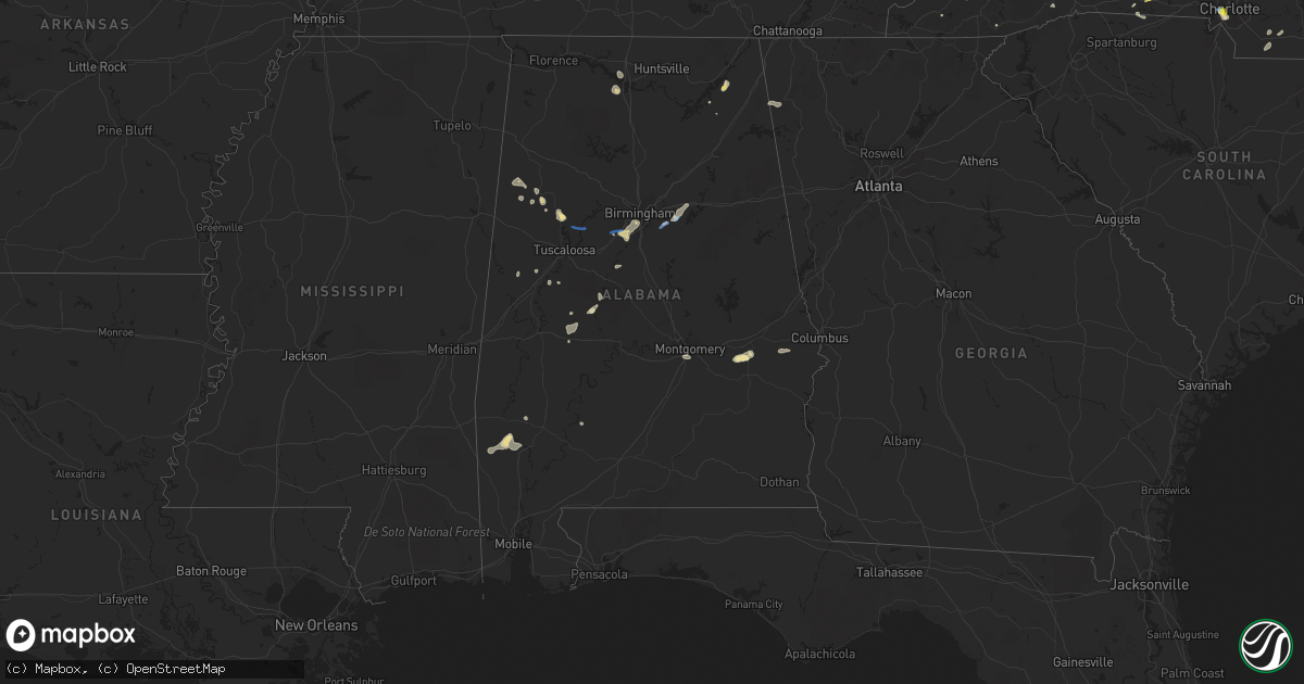
Hail Map in Alabama on August 19, 2019
Get this storm
August 19 map
$229
one time, instant access
Download today. No call, no setup
Keep the $229
Bought the map and want the full workflow? Apply the entire $229 to a subscription within 7 days. None of it is wasted.
Every map, not just this one
This buys you this map. Subscription and you get every map we run, in the markets you choose from a few cities to whole states to nationwide. Plus real-time alerts the moment a storm fires.
Contact data
Name, contact info, occupancy, even credit band for addresses in the footprint. You go from where it hit to who to call.
Become the source they trust
Unlimited branding weather history reports on demand. You already have the documented answer ready for the property owner, and you are the one who showed up with it.
Property data and RoofTrace estimates
Pull up any address you have got, its value and the exact code rules for that jurisdiction, straight from One Click Code. Then RoofTrace estimates the squares, pitch, and roof value, priced the way you price.
Storm reports in Alabama
Alabama
| Date | Description |
|---|---|
| 08/19/20196:46 PM CDT | Trees and power lines down. Time estimated by radar. |
| 08/19/20196:46 PM CDT | Trees and power lines down near hwy 480 and hwy 50. Time estimated by radar. |
| 08/19/20196:45 PM CDT | Tree down on home in lipscomb. Time estimated by radar. |
| 08/19/20196:45 PM CDT | Tree reported down at 400 alexander road. Time estimated by radar. |
| 08/19/20196:41 PM CDT | Trees down along hwy 55 ... Northeast of sterrett... Al. Time estimated by radar. |
| 08/19/20196:17 PM CDT | Corrects previous tstm wnd dmg report from 5 n columbiana. Trees and power lines down near chelsea rd and foster rd. Time estimated by radar and arrival of gust front. |
| 08/19/20196:11 PM CDT | Corrects previous tstm wnd dmg report from 1 s highland lakes. Tree reported down at 299 linwood road. Time estimated by radar. |
| 08/19/20196:03 PM CDT | Corrects previous tstm wnd dmg report from mount laurel. Numerous trees down along hwy 41 near stonegate drive and connemara trail area. Time estimated by radar. |
| 08/19/20195:58 PM CDT | Corrects previous tstm wnd dmg report from 3 e shoal creek golf club. Trees and power lines down along bear creek road. Time estimated by radar. |
| 08/19/20195:55 PM CDT | Ema reports trees down within decatur city limits. |
| 08/19/20195:46 PM CDT | Corrects previous tstm wnd dmg report from 3 nne wehapa lake. Trees and power lines down. Time estimated by radar. |
| 08/19/20195:46 PM CDT | Corrects previous tstm wnd dmg report from 1 nne vandiver. Trees and power lines down near hwy 480 and hwy 50. Time estimated by radar. |
| 08/19/20195:45 PM CDT | Corrects previous tstm wnd dmg report from 2 n vandiver. Tree reported down at 400 alexander road. Time estimated by radar. |
| 08/19/20195:41 PM CDT | Corrects previous tstm wnd dmg report from 3 nne sterrett. Trees down along hwy 55 ... Northeast of sterrett... Al. Time estimated by radar. |
| 08/19/20195:35 PM CDT | Roof and minor structural damage was reported at two neighboring farm buildings on county rd 47. Time estimated by radar. |
| 08/19/20195:30 PM CDT | Trees down on hwy 331 in montgomery. Fire station had minor roof damage. Time estimated. Winds estimated 40-50mph. |
| 08/19/20194:06 PM CDT | Trees were blown down and a roof was blown off a mobile home along shiver de freeze road in far northern tuscaloosa county. |
| 08/19/20193:11 PM CDT | A tree has fallen on a home on 6th ave nw. The home was also hit by lightning. Winds estimated at 50 mph. |
| 08/19/20193:10 PM CDT | A roof was blown off a building on cleveland ave. Winds estimated at 50 mph. |
| 08/19/20193:08 PM CDT | A large tree was blown down near mcdonalds on chestnut in attalla. Winds estimated at 50 mph. |
| 08/19/20193:06 PM CDT | A large tree and power lines were downed near chestnut and cleveland. Winds estimated at 45 mph. |
| 08/19/20193:00 PM CDT | A tree was blown down and into the roadway on cr 52 north of weiss lake. |
| 08/19/20191:42 PM CDT | Several trees were blown down along highway 5 northeast of marion. |
| 08/19/20191:37 PM CDT | Corrects previous tstm wnd dmg report from 3 ssw heiberger. Several trees were blown down along cr 16. Time estimated by radar. |
| 08/19/20191:30 PM CDT | Several trees were blown down along cr 16. |
| 08/19/20191:29 PM CDT | A tree was knocked down onto a residence in pine ridge. |
| 08/19/20191:06 PM CDT | Several trees down onto cr 156 in the section area. Time estimated by radar. |
| 08/19/201912:24 AM CDT | At 523 PM CDT, a severe thunderstorm was located over southwestern Montgomery, and is nearly stationary. HAZARD...60 mph wind gusts and penny size hail. SOURCE...Radar indicated. IMPACT...Expect damage to roofs, siding, and trees. Locations impacted include... Montgomery, Hunter, Dannelly Field, Maxwell Air Force Base, Snowdoun, Hyundai Motors Of Alabama, Alabama State University, Montgomery Riverwalk Stadium, Pinedale, Hope Hull, Woodcrest and Alabama State Capitol. |
| 08/19/201912:12 AM CDT | At 512 PM CDT, a severe thunderstorm was located near Hardaway, or 10 miles northwest of Union Springs, and is nearly stationary. HAZARD...60 mph wind gusts and penny size hail. SOURCE...Radar indicated. IMPACT...Expect damage to roofs, siding, and trees. Locations impacted include... Hardaway, Liverpool, Cross Keys and Fort Davis. |
| 08/19/201912:09 AM CDT | At 509 PM CDT, a severe thunderstorm was located 6 miles north of Chatom, moving west at 15 mph. HAZARD...60 mph wind gusts and penny size hail. SOURCE...Radar indicated. IMPACT...Expect damage to roofs, siding, and trees. Locations impacted include... Chatom, Saint Stephens, Wagarville and Millry. |
| 08/18/201911:51 PM CDT | At 451 PM CDT, a severe thunderstorm was located 5 miles northwest of Saint Stephens, or 10 miles northeast of Chatom, and is nearly stationary. HAZARD...60 mph wind gusts and penny size hail. SOURCE...Radar indicated. IMPACT...Expect damage to roofs, siding, and trees. Locations impacted include... Saint Stephens and Leroy. |
| 08/18/20199:55 PM CDT | At 255 PM CDT, a severe thunderstorm was located over Dothan, moving southwest at 15 mph. HAZARD...60 mph wind gusts and penny size hail. SOURCE...Radar indicated. IMPACT...Expect damage to roofs, siding, and trees. Locations impacted include... Dothan, Headland, Taylor, Midland City, Kinsey, Ashford, Slocomb, Cowarts, Newton, Webb, Pinckard, Malvern, Rehobeth, Grimes, Avon, Napier Field, Memphis, Hollis Dairy Road, Enon and Wilson Mill. |
| 08/18/20198:36 PM CDT | At 136 PM CDT, a severe thunderstorm was located near Marion, moving southwest at 20 mph. HAZARD...60 mph wind gusts and quarter size hail. SOURCE...Radar indicated. IMPACT...Hail damage to vehicles is expected. Expect wind damage to roofs, siding, and trees. Locations impacted include... Marion, Heiberger, Sprott, Folsom and Judson College. |
| 08/18/20198:14 PM CDT | At 114 PM CDT, a severe thunderstorm was located near Powell, or 8 miles north of Rainsville, moving northeast at 10 mph. HAZARD...60 mph wind gusts and quarter size hail. SOURCE...Radar indicated. IMPACT...Hail damage to vehicles is expected. Expect wind damage to roofs, siding, and trees. Locations impacted include... Scottsboro, Rainsville, Henagar, Sylvania, Powell, Section, Pisgah and Dutton. |
| 08/18/20197:15 PM CDT | Tree reported down at 299 linwood road. Time estimated by radar. |
| 08/18/20197:08 PM CDT | Trees and power lines down near chelsea rd and foster rd. Time estimated by radar and arrival of gust front. Winds estimated 40mph. |
| 08/18/20197:00 PM CDT | Trees and power lines down along bear creek road. Time estimated by radar. |
| 08/18/20197:00 PM CDT | Numerous trees and power lines down in bessemer. Time estimated by radar. |
| 08/18/20197:00 PM CDT | Numerous trees down along hwy 41 near stonegate drive and connemara trail area. Time estimated by radar. |
All States Impacted by Hail Map on August 19, 2019
Cities Impacted by Hail Map on August 19, 2019
- Afton, VA
- Greenwood, VA
- Bryson City, NC
- Scottsburg, VA
- Virgilina, VA
- Royston, GA
- Greensboro, NC
- Charlottesville, VA
- Earlysville, VA
- Free Union, VA
- Crozet, VA
- Humboldt, IA
- Hardy, IA
- Dickinson, ND
- Belfield, ND
- Fairfield, ND
- Pennsauken, NJ
- Cherry Hill, NJ
- Merchantville, NJ
- Camden, NJ
- Oberlin, KS
- Sperryville, VA
- Frankville, AL
- Millry, AL
- Chatom, AL
- Sherburn, MN
- Lee, NH
- Georgetown, MN
- Sainte Genevieve, MO
- Farmington, MO
- Hardaway, AL
- Tuskegee, AL
- Charlotte, NC
- Knightdale, NC
- Raleigh, NC
- Goldsboro, NC
- Lewes, DE
- Ramseur, NC
- Liberty, NC
- Staley, NC
- Perley, MN
- Borup, MN
- Hartwell, GA
- Oakton, VA
- Reston, VA
- Vienna, VA
- Devils Lake, ND
- Leeds, ND
- Argusville, ND
- Canton, GA
- Knoxville, AL
- Keystone, IA
- Elberon, IA
- Patoka, IL
- Verndale, MN
- Rehoboth Beach, DE
- Cove City, NC
- Old Fort, NC
- Springfield, MA
- Longmeadow, MA
- Feeding Hills, MA
- Agawam, MA
- Southwick, MA
- Kinston, NC
- Adairsville, GA
- Calhoun, GA
- Jeffers, MN
- Sanborn, MN
- Decatur, AL
- Eastchester, NY
- Tuckahoe, NY
- New Rochelle, NY
- Tuttle, ND
- Wannaska, MN
- Marion, NC
- Easley, SC
- Marshville, NC
- Peachland, NC
- Toledo, IA
- Dysart, IA
- Luzerne, IA
- Belle Plaine, IA
- Clutier, IA
- Geraldine, AL
- Liberty, SC
- Iowa City, IA
- Lone Tree, IA
- Riverside, IA
- Hills, IA
- Fairmont, MN
- Staples, MN
- Aldrich, MN
- Bertha, MN
- Trappe, MD
- Marion, AL
- Philadelphia, PA
- Vredenburgh, AL
- Franklin, AL
- Sterrett, AL
- Vincent, AL
- Woden, IA
- Britt, IA
- Titonka, IA
- Wesley, IA
- Vernon, CO
- Wray, CO
- Pell City, AL
- Vandiver, AL
- Fairmount, GA
- Manning, ND
- Barnegat, NJ
- Beach Haven, NJ
- Waretown, NJ
- Barnegat Light, NJ
- Belleville, IL
- Scott Air Force Base, IL
- O'Fallon, IL
- Freeburg, IL
- Mascoutah, IL
- West Springfield, MA
- Westfield, MA
- East Longmeadow, MA
- Hampden, MA
- Holly, CO
- Blanchard, ND
- Hatton, ND
- Mayville, ND
- Portland, ND
- Northwood, ND
- Windom, MN
- Fenton, IA
- Hendrum, MN
- Harwood, ND
- Gardner, ND
- Ada, MN
- Hobson, MT
- Trimont, MN
- Plains, KS
- Meade, KS
- Cleveland, GA
- Sautee Nacoochee, GA
- Montross, VA
- Pekin, ND
- Petersburg, ND
- Tolna, ND
- Niagara, ND
- Minnewaukan, ND
- Mcville, ND
- Penn, ND
- Churchs Ferry, ND
- Crary, ND
- Aneta, ND
- Larimore, ND
- Lakota, ND
- Michigan, ND
- York, ND
- Seneca, SC
- Woodville, MS
- Saint Stephens, AL
- Rome, GA
- Livermore, IA
- Lu Verne, IA
- Athens, GA
- Watkinsville, GA
- Bogart, GA
- Meherrin, VA
- Rugby, ND
- Georgetown, DE
- Harbeson, DE
- Milton, DE
- Freehold, NJ
- Jefferson, GA
- Summerville, GA
- Scottsville, VA
- Palmyra, VA
- Belchertown, MA
- Algona, IA
- Graettinger, IA
- Bancroft, IA
- Burt, IA
- Cylinder, IA
- Whittemore, IA
- Emmetsburg, IA
- Lone Rock, IA
- Stafford Springs, CT
- Mountain Lake, MN
- Bingham Lake, MN
- Livermore, ME
- Newbern, AL
- Kensett, IA
- Wilton, CT
- New Canaan, CT
- Denton, NC
- Lexington, NC
- Cuthbert, GA
- Chapin, SC
- Little Mountain, SC
- Louisburg, NC
- Cameron, NC
- Sanford, NC
- Section, AL
- Dutton, AL
- Nashua, IA
- Thor, IA
- Badger, IA
- Cumming, GA
- Alpharetta, GA
- Union Mills, NC
- Lake Lure, NC
- Fairfax, IA
- Amana, IA
- Herndon, KS
- Perham, MN
- New York Mills, MN
- Mocksville, NC
- Harmony, NC
- Ringsted, IA
- Wallingford, IA
- Estherville, IA
- Lookout Mountain, GA
- Flintstone, GA
- Menahga, MN
- Newhall, IA
- Watkins, IA
- Lesterville, MO
- Amherst, MA
- Buffalo Junction, VA
- South Boston, VA
- Fayette, AL
- Rutland, IA
- Dakota City, IA
- Eagle Grove, IA
- Goldfield, IA
- Sterling, VA
- McLean, VA
- Dunn Loring, VA
- Falls Church, VA
- Herndon, VA
- Great Falls, VA
- Frazee, MN
- Sebeka, MN
- Keysville, VA
- Green Bay, VA
- Wade, NC
- Linden, NC
- Corwith, IA
- Renwick, IA
- Upper Marlboro, MD
- Moorestown, NJ
- Riverton, NJ
- Maple Shade, NJ
- Wingate, NC
- Monroe, NC
- Marlton, NJ
- Voorhees, NJ
- Gary, MN
- Twin Valley, MN
- Terril, IA
- Pisgah Forest, NC
- Penrose, NC
- Brierfield, AL
- Greenville, IL
- Springfield, MN
- Comfrey, MN
- McCalla, AL
- Birmingham, AL
- Bessemer, AL
- Helena, AL
- Turpin, OK
- Milford, VA
- Walnut Hill, IL
- Centralia, IL
- Yadkinville, NC
- Clare, IA
- Starr, SC
- Iva, SC
- Traer, IA
- Piney Point, MD
- Heathsville, VA
- Northport, AL
- Berry, AL
- Kinards, SC
- Lancaster, MN
- Dewy Rose, GA
- Towner, ND
- Northwood, IA
- Lake Mills, IA
- Badger, MN
- Greenwich, CT
- Nisswa, MN
- Pine River, MN
- Pequot Lakes, MN
- Cushing, MN
- Pillager, MN
- Brainerd, MN
- Motley, MN
- Perryton, TX
- Victoria, VA
- Ackley, IA
- Iowa Falls, IA
- Alden, IA
- Lyerly, GA
- Winnebago, MN
- Delavan, MN
- Storden, MN
- Zebulon, NC
- Middlesex, NC
- Laurens, SC
- Mountville, SC
- Waterloo, SC
- Chicopee, MA
- Oconee, IL
- Lusby, MD
- Birch Tree, MO
- Kenbridge, VA
- Odin, IL
- Sandoval, IL
- Mulberry Grove, IL
- Keyesport, IL
- Carlyle, IL
- Vandalia, IL
- Smithboro, IL
- Hillsboro, ND
- Marengo, IA
- Newberry, SC
- Silverstreet, SC
- Jackson, MN
- Cheltenham, PA
- Merion Station, PA
- Wynnewood, PA
- Norway, IA
- Kenly, NC
- Sims, NC
- Chelsea, IA
- Walsh, CO
- Chantilly, VA
- Catharpin, VA
- Fort Dodge, IA
- Gilmore City, IA
- Vincent, IA
- Spirit Lake, IA
- Dolliver, IA
- Mars Hill, NC
- Buffalo Center, IA
- Thompson, IA
- Dunnell, MN
- Boston, VA
- Groveoak, AL
- West Jefferson, NC
- Bryant Pond, ME
- Hanlontown, IA
- Joice, IA
- Greenbush, MN
- Fayetteville, NC
- Travelers Rest, SC
- Taylors, SC
- Greer, SC
- Marietta, SC
- Trenton, IL
- Aviston, IL
- Highland, IL
- Leland, IA
- Millstone Township, NJ
- Cream Ridge, NJ
- Englishtown, NJ
- Jackson, NJ
- Howell, NJ
- Spring Hope, NC
- Elm City, NC
- Wilson, NC
- Lena, LA
- Flatwoods, LA
- Beaver City, NE
- Hendley, NE
- Pendleton, SC
- Teutopolis, IL
- Kodak, TN
- Sevierville, TN
- Armuchee, GA
- Kingston, OH
- Circleville, OH
- Snow Camp, NC
- Siler City, NC
- Adams, ND
- Spring Lake, NC
- Burkeville, VA
- Avoca, MN
- Gaylesville, AL
- Central, SC
- Fremont, NC
- Pikeville, NC
- Winder, GA
- Reva, VA
- Wendell, NC
- Robinson, ND
- Ninety Six, SC
- Chappells, SC
- Bailey, NC
- Montgomery, AL
- Baxter, MN
- Pocahontas, IL
- Fairdale, ND
- Millstadt, IL
- Smithton, IL
- Wing, ND
- Epping, NH
- Eutaw, AL
- Scarsdale, NY
- Mount Vernon, NY
- Larchmont, NY
- Pelham, NY
- Bronxville, NY
- Yonkers, NY
- Mamaroneck, NY
- Youngsville, NC
- Wake Forest, NC
- Rolesville, NC
- West Union, SC
- Walhalla, SC
- Westminster, SC
- Gladbrook, IA
- Eatontown, NJ
- Colts Neck, NJ
- Trion, GA
- Aldie, VA
- Middleburg, VA
- Leesburg, VA
- Gray Court, SC
- Morganton, NC
- Heron Lake, MN
- Monson, MA
- West Suffield, CT
- Trenton, NC
- Dover, NC
- Huntersville, NC
- Culpeper, VA
- Rocky Mount, NC
- Tarboro, NC
- Pollock, LA
- Welcome, MN
- Blair, SC
- Wadena, MN
- Ceylon, MN
- Lancaster, VA
- Weems, VA
- Kilmarnock, VA
- Caledonia, ND
- Blackstone, VA
- Hampden, ND
- Glassboro, NJ
- Sewell, NJ
- Williamstown, NJ
- Leeds, ME
- Hamptonville, NC
- Forest City, NC
- Ellenboro, NC
- Mooresboro, NC
- Clemson, SC
- Willingboro, NJ
- Burlington, NJ
- Vernon, AL
- Sulligent, AL
- Shelby, NC
- Osage, MN
- Detroit Lakes, MN
- Wheatland, ND
- Casselton, ND
- Saint Peter, IL
- Ware, MA
- Wilbraham, MA
- Wales, MA
- Stewardson, IL
- Shumway, IL
- Plainville, GA
- Effingham, IL
- Dundas, VA
- Cedar Rapids, IA
- Clarksville, VA
- Runnemede, NJ
- Hague, VA
- Chesnee, SC
- Indian Orchard, MA
- Ludlow, MA
- Greenwood, ME
- Radcliffe, IA
- Ellsworth, IA
- Munich, ND
- Ellington, MO
- Kennedy, AL
- Millport, AL
- Seaside Park, NJ
- Forked River, NJ
- Talking Rock, GA
- Jasper, GA
- Ulen, MN
- Waubun, MN
- Spruce Pine, NC
- Moundville, AL
- Milford, IA
- Mchenry, ND
- Durham, NH
- Linton, IN
- Fairview Heights, IL
- Lebanon, IL
- Waterloo, IL
- Robbins, NC
- Nashville, NC
- Van Horne, IA
- Garrison, IA
- Garwin, IA
- Reinbeck, IA
- Hudson, IA
- Buckingham, IA
- Hubbard, IA
- Grace City, ND
- Catawba, NC
- Claremont, NC
- Westport, CT
- Weston, CT
- Fairfield, CT
- Plant City, FL
- Bunnlevel, NC
- Hammonton, NJ
- Thomaston, AL
- Uniontown, AL
- Redding, CT
- Easton, CT
- Idalia, CO
- Chatsworth, NJ
- Vincentown, NJ
- Turner, ME
- Buckfield, ME
- Ironton, MO
- Rockwell, IA
- Felton, MN
- Grandin, ND
- Ogema, MN
- Arthur, ND
- Selbyville, DE
- Alberta, VA
- Tappahannock, VA
- Haymarket, VA
- Andrews, NC
- Bala Cynwyd, PA
- Narberth, PA
- Havertown, PA
- Collingswood, NJ
- Ardmore, PA
- Statesville, NC
- Newton, NC
- Appomattox, VA
- Orlando, FL
- Windermere, FL
- Wayne, ME
- Mount Kisco, NY
- Armonk, NY
- Gaffney, SC
- Augusta, ME
- Kinsale, VA
- West Paris, ME
- Dawsonville, GA
- Marshall, MN
- Cottonwood, MN
- Cave Spring, GA
- Swea City, IA
- Carlisle, SC
- Woolstock, IA
- Ocean City, MD
- Haddonfield, NJ
- Anderson, SC
- Scotland, MD
- Glendora, NJ
- Woodbury, NJ
- Bellmawr, NJ
- Westville, NJ
- Barrington, NJ
- Westbrook, MN
- Butterfield, MN
- Lamberton, MN
- Stantonsburg, NC
- Saint James, MN
- Alma, IL
- Frankford, DE
- Bishopville, MD
- Pittsboro, NC
- Knoxville, TN
- Dix, IL
- Mount Vernon, IL
- Readfield, ME
- Manchester, ME
- Winthrop, ME
- Bennett, NC
- Coffeeville, AL
- Highlands, NC
- Ruckersville, VA
- Pickens, SC
- Hodges, SC
- Pope Army Airfield, NC
- Fort Bragg, NC
- Colonial Beach, VA
- The Plains, VA
- Waleska, GA
- Woodford, VA
- Deep Run, NC
- Lottsburg, VA
- Callao, VA
- Caseyville, IL
- Collinsville, IL
- Troy, IL
- Gainesville, GA
- Athens, AL
- Tanner, AL
- Gainesville, VA
- Bristow, VA
- Manassas, VA
- Greenwood, SC
- Bode, IA
- Ruthven, IA
- Okoboji, IA
- Armstrong, IA
- Arnolds Park, IA
- West Bend, IA
- Beecher City, IL
- Alpha, MN
- Darfur, MN
- Fulda, MN
- Waynesboro, VA
- Lewisville, NC
- Clemmons, NC
- Edmore, ND
- Melbourne, AR
- Lawndale, NC
- Lakota, IA
- Buckatunna, MS
- State Line, MS
- Derry, NH
- Austinville, VA
- Max Meadows, VA
- Chickamauga, GA
- Akron, AL
- Annapolis, MO
- Vulcan, MO
- Forgan, OK
- Advance, NC
- Union Springs, AL
- Browerville, MN
- Hewitt, MN
- Bluffton, MN
- Hatchechubbee, AL
- Madison, GA
- Chester, VA
- Richmond, VA
- Asheboro, NC
- Seagrove, NC
- New Straitsville, OH
- Suffield, CT
- Mahnomen, MN
- Callaway, MN
- Park Rapids, MN
- Walker, MN
- Rochert, MN
- White Earth, MN
- Ponsford, MN
- Laporte, MN
- Hackensack, MN
- Naytahwaush, MN
- Lake George, MN
- Backus, MN
- Nevis, MN
- Bagley, MN
- Akeley, MN
- Fosston, MN
- Bejou, MN
- Fort Ripley, MN
- Lookout Mountain, TN
- Remsen, IA
- Marcus, IA
- Clarion, IA
- Gray, IA
- Templeton, IA
- Audubon, IA
- Kirkman, IA
- Defiance, IA
- Harlan, IA
- Manning, IA
- Manilla, IA
- Irwin, IA
- Auburn, IA
- Lytton, IA
- Lake City, IA
- Vail, IA
- Breda, IA
- Westside, IA
- Carroll, IA
- Rockwell City, IA
- Arcadia, IA
- Quimby, IA
- Cherokee, IA
- Cleghorn, IA
- Scranton, IA
- Glidden, IA
- Ralston, IA
- Coon Rapids, IA
- Earlham, IA
- Van Meter, IA
- Winterset, IA
- Uxbridge, MA
- Slatersville, RI
- Harrisville, RI
- Douglas, MA
- Webster, MA
- Dudley, MA
- North Smithfield, RI
- North Grosvenordale, CT
- Pascoag, RI
- Thompson, CT
- Plainville, MA
- Attleboro Falls, MA
- North Attleboro, MA
- Grass Range, MT
- Lewistown, MT
- Gloucester City, NJ
- Bordentown, NJ
- Columbus, NJ
- Jobstown, NJ
- Wrightstown, NJ
- Medford, NJ
- Farmingdale, NJ
- Waterford Works, NJ
- Knox, ND
- Wolford, ND
- Bowdon, ND
- Buxton, ND
- Strawberry Plains, TN
- Hornick, IA
- Smithland, IA
- Earling, IA
- Panama, IA
- Westphalia, IA
- Danbury, IA
- Anthon, IA
- Battle Creek, IA
- Oto, IA
- Holstein, IA
- Cushing, IA
- Galva, IA
- Washta, IA
- Correctionville, IA
- Kimballton, IA
- Chillicothe, IA
- Milo, IA
- What Cheer, IA
- Packwood, IA
- Ackworth, IA
- Sigourney, IA
- Eldon, IA
- Ollie, IA
- Floris, IA
- Saint Charles, IA
- Melcher Dallas, IA
- Chariton, IA
- New Sharon, IA
- Hayesville, IA
- Eddyville, IA
- Hedrick, IA
- Martensdale, IA
- Cumming, IA
- Udell, IA
- University Park, IA
- Prole, IA
- Lacona, IA
- Agency, IA
- Fairfield, IA
- Williamson, IA
- Indianola, IA
- Bussey, IA
- Pleasantville, IA
- Tracy, IA
- Rose Hill, IA
- Norwalk, IA
- Drakesville, IA
- Woodburn, IA
- Unionville, IA
- Osceola, IA
- Hamilton, IA
- Moravia, IA
- Liberty Center, IA
- Batavia, IA
- Fremont, IA
- New Virginia, IA
- Blakesburg, IA
- Russell, IA
- Bloomfield, IA
- Leighton, IA
- Melrose, IA
- Albia, IA
- Martinsburg, IA
- Bevington, IA
- Beacon, IA
- Cedar, IA
- Knoxville, IA
- Lovilia, IA
- Saint Marys, IA
- Lucas, IA
- Kirkville, IA
- Delta, IA
- Centerville, IA
- Richland, IA
- Oskaloosa, IA
- Ottumwa, IA
- Columbia, IA
- Cambridge, IA
- Maxwell, IA
- Mingo, IA
- Collins, IA
- Adair, IA
- Casey, IA
- Stuart, IA
- Exira, IA
- Redfield, IA
- Menlo, IA
- Panora, IA
- Dexter, IA
- Adel, IA
- Guthrie Center, IA
- Hamlin, IA
- Linden, IA
- West Des Moines, IA
- Berwick, IA
- Johnston, IA
- Mitchellville, IA
- Newton, IA
- Prairie City, IA
- Otley, IA
- Reasnor, IA
- Swan, IA
- Altoona, IA
- Lynnville, IA
- Des Moines, IA
- Killduff, IA
- Carlisle, IA
- Harvey, IA
- Sully, IA
- Runnells, IA
- Elkhart, IA
- Montezuma, IA
- Bondurant, IA
- Hartford, IA
- Pleasant Hill, IA
- Ankeny, IA
- Searsboro, IA
- Monroe, IA
- Grinnell, IA
- Urbandale, IA
- Pella, IA
- Colfax, IA
- Tuscaloosa, AL
- Bantry, ND
- Brocket, ND
- Southport, CT
- Bridgeport, CT
- White Oak, NC
- Madbury, NH
- Nottingham, NH
- Dover, NH
- Elkhart, KS


