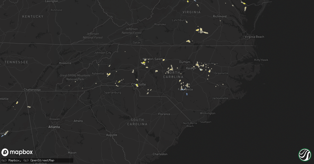
Hail Map in North Carolina on August 19, 2019
Get this storm
August 19 map
$229
one time, instant access
Download today. No call, no setup
Keep the $229
Bought the map and want the full workflow? Apply the entire $229 to a subscription within 7 days. None of it is wasted.
Every map, not just this one
This buys you this map. Subscription and you get every map we run, in the markets you choose from a few cities to whole states to nationwide. Plus real-time alerts the moment a storm fires.
Contact data
Name, contact info, occupancy, even credit band for addresses in the footprint. You go from where it hit to who to call.
Become the source they trust
Unlimited branding weather history reports on demand. You already have the documented answer ready for the property owner, and you are the one who showed up with it.
Property data and RoofTrace estimates
Pull up any address you have got, its value and the exact code rules for that jurisdiction, straight from One Click Code. Then RoofTrace estimates the squares, pitch, and roof value, priced the way you price.
Storm reports in North Carolina
North Carolina
| Date | Description |
|---|---|
| 08/19/20196:00 PM CDT | Hail up to the size of quarters. |
| 08/19/20196:00 PM CDT | 2 trees known to be down from the storm near sheffield. One small tree down from this storm toward farmington. |
| 08/19/20194:55 PM CDT | A dozen trees reported down in lewisville. |
| 08/19/20194:45 PM CDT | Tree down on friendly avenue. |
| 08/19/20194:45 PM CDT | Multiple reports of trees down scattered across greensboro. |
| 08/19/20194:30 PM CDT | Thunderstorm winds downed at least four trees on a homeowners property within the town of staley... Nc. Report relayed via social media. |
| 08/19/20194:02 PM CDT | Tree down near 9100 racine rd in pleasant garden. |
| 08/19/20194:00 PM CDT | Powerline down causing major power outages on knightdale blvd & rose of sharon rd. |
| 08/19/20193:52 PM CDT | Quarter sized hail in lattimore. |
| 08/19/20193:50 PM CDT | Tree reported down on bass mountain road. Other trees down near snow camp. |
| 08/19/20193:44 PM CDT | Tree down on mobley rd @ us 301 south. |
| 08/19/20193:44 PM CDT | Tree down @ us 264 near mm 47. |
| 08/19/20193:44 PM CDT | Multiple trees down @ mm 49 us 264. |
| 08/19/20193:41 PM CDT | Tree down on nc 42 south and us 64. |
| 08/19/20193:33 PM CDT | Tree down on school road and pridgenfarm rd. |
| 08/19/20193:28 PM CDT | Tree down on cabarrus st & s east st. |
| 08/19/20193:26 PM CDT | Tree down on dorthea dr & s saunders st. |
| 08/19/20193:25 PM CDT | Large tree limb down on cabarrus street. |
| 08/19/20193:25 PM CDT | Multiple trees down in west raleigh near dorothea dix park. |
| 08/19/20193:25 PM CDT | Tree reported down at woodburn road and hillsborough street raleigh nc. Report from wral. |
| 08/19/20193:23 PM CDT | Multiple large oak trees down at dorothea dix park. |
| 08/19/20193:23 PM CDT | Powerline down @ troy rd and cedar creek rd. |
| 08/19/20193:17 PM CDT | 65 mph peak wind gust from the southeast. |
| 08/19/20193:11 PM CDT | Half dollar sized hail reported at the charlotte douglas international airport. |
| 08/19/20193:10 PM CDT | Dime to quarter sized hail on wilkinson blvd. |
| 08/19/20192:50 PM CDT | Tree reported down on cliffdale road. |
| 08/19/20192:50 PM CDT | Tree down on christina street. Time estimated by radar. Report from spectrum news. |
| 08/19/20192:20 PM CDT | At least a few trees down around penrose. |
| 08/19/20192:20 PM CDT | Several trees down and a few power lines. |
| 08/19/20191:55 PM CDT | A few trees down near barbecue church road and route 87. Time estimated by radar. |
| 08/19/20191:52 PM CDT | Multiple trees down and a few power lines. |
| 08/19/20191:45 PM CDT | Tree down on a d hall rd. |
| 08/19/20191:10 PM CDT | Up to 20 trees down at lake julian park along with some damage to boats in marina. Nickel size hail covered the ground. |
| 08/19/201912:17 PM CDT | One tree down along the 2800 block of collinstown road. |
| 08/19/20191:40 AM CDT | At 639 PM EDT, a severe thunderstorm was located 5 miles north of Mocksville, moving southwest at 5 mph. HAZARD...60 mph wind gusts and quarter size hail. SOURCE...Radar indicated. IMPACT...Minor hail damage to vehicles is expected. Expect wind damage to trees and power lines. Locations impacted include... Mocksville, Bermuda Run, Harmony, Fork Church, Advance, Sheffield, Farmington and Cool Springs. |
| 08/19/201912:42 AM CDT | At 542 PM EDT, severe thunderstorms were located along a line extending from near Kernersville to 6 miles east of Cooleemee, and are nearly stationary. HAZARD...60 mph wind gusts and quarter size hail. SOURCE...Radar indicated. IMPACT...Hail damage to vehicles is expected. Expect wind damage to roofs, siding, and trees. Locations impacted include... Winston-Salem, Lexington, Thomasville, Kernersville, Clemmons, Bermuda Run, Huntsville, Linwood, Lewisville and Walkertown. |
| 08/19/201912:33 AM CDT | At 533 PM EDT, a severe thunderstorm was located near Greensboro, moving west at 10 mph. HAZARD...60 mph wind gusts and quarter size hail. SOURCE...Radar indicated. IMPACT...Hail damage to vehicles is expected. Expect wind damage to roofs, siding, and trees. Locations impacted include... Greensboro, High Point, Kernersville, McLeansville, Summerfield, Gibsonville, Stokesdale, Pleasant Garden, Jamestown and Lake Guilford Mackintosh Marina. |
| 08/19/201912:30 AM CDT | At 529 PM EDT, a severe thunderstorm was located 9 miles east of Newton, or near Catawba, and is nearly stationary. HAZARD...60 mph wind gusts and quarter size hail. SOURCE...Radar indicated. IMPACT...Minor hail damage to vehicles is expected. Expect wind damage to trees and power lines. Locations impacted include... Newton, Maiden, Troutman, Claremont, Catawba, Lake Norman, Lake Norman State Park, Lookout Shoals Lake, Sherrills Ford and Bandys. |
| 08/19/201912:25 AM CDT | At 525 PM EDT, a severe thunderstorm was located 7 miles west of Siler City, moving west at 20 mph. HAZARD...60 mph wind gusts and quarter size hail. SOURCE...Radar indicated. IMPACT...Hail damage to vehicles is expected. Expect wind damage to roofs, siding, and trees. Locations impacted include... High Point, Asheboro, Randleman, North Carolina Zoo, Siler City, Seagrove, Archdale, Liberty, Ramseur and Franklinville. |
| 08/18/201911:59 PM CDT | At 459 PM EDT, a severe thunderstorm was located 8 miles south of Wake Forest, or 8 miles east of Raleigh, moving northeast at 5 mph. HAZARD...60 mph wind gusts and quarter size hail. SOURCE...Radar indicated. IMPACT...Hail damage to vehicles is expected. Expect wind damage to roofs, siding, and trees. Locations impacted include... Raleigh, Wake Forest, Zebulon, Knightdale, Wendell and Rolesville. |
| 08/18/201911:57 PM CDT | At 456 PM EDT, a cluster of severe thunderstorms were located 8 miles southeast of Wilson, or 14 miles west of Farmville, moving south at 10 mph. HAZARD...60 mph wind gusts and quarter size hail. SOURCE...Radar indicated. IMPACT...Hail damage to vehicles is expected. Expect wind damage to roofs, siding, and trees. Locations impacted include... Kinston, Farmville, Snow Hill, Maury, Institute, Jason, Dawson, Lizzie, Fountain, Castoria, Shine, Fort Run VFD, Bull Head VFD, Walstonburg and Falkland. |
| 08/18/201911:43 PM CDT | At 443 PM EDT, severe thunderstorms were located along a line extending from near Siler City to 7 miles southeast of High Rock Lake, moving south at 10 mph. HAZARD...60 mph wind gusts and penny size hail. SOURCE...Radar indicated. IMPACT...Expect damage to roofs, siding, and trees. Locations impacted include... High Point, Asheboro, Lexington, Albemarle, Randleman, Siler City, Badin Lake, North Carolina Zoo, Thomasville and Goldston. |
| 08/18/201911:31 PM CDT | At 431 PM EDT, a severe thunderstorm was located near Bunn, or 7 miles southwest of Louisburg, and is nearly stationary. HAZARD...60 mph wind gusts and penny size hail. SOURCE...Radar indicated. IMPACT...Expect damage to roofs, siding, and trees. Locations impacted include... Louisburg, Wake Forest, Zebulon, Franklinton, Bunn, Wendell, Rolesville, Youngsville, Centerville and Pilot. |
| 08/18/201911:25 PM CDT | At 425 PM EDT, a severe thunderstorm was located near Wilson, or 18 miles south of Nashville, moving southwest at 10 mph. HAZARD...60 mph wind gusts and quarter size hail. SOURCE...Radar indicated. IMPACT...Hail damage to vehicles is expected. Expect wind damage to roofs, siding, and trees. Locations impacted include... Rocky Mount, Tarboro, Nashville, Wilson, Clayton, Elm City, Fremont, Dortches, Bailey and Micro. |
| 08/18/201911:20 PM CDT | At 420 PM EDT, a severe thunderstorm was located near Garner, or near Raleigh, and is nearly stationary. HAZARD...60 mph wind gusts and quarter size hail. SOURCE...Radar indicated. IMPACT...Hail damage to vehicles is expected. Expect wind damage to roofs, siding, and trees. Locations impacted include... Raleigh, Cary, Garner, Knightdale, Lake Wheeler, Lake Benson and William B Umstead State Park. |
| 08/18/201911:18 PM CDT | At 418 PM EDT, a severe thunderstorm was located 4 miles west of Gaffney, and is nearly stationary. HAZARD...60 mph wind gusts and quarter size hail. SOURCE...Radar indicated. IMPACT...Minor hail damage to vehicles is expected. Expect wind damage to trees and power lines. Locations impacted include... Gaffney, Cowpens, Pacolet Mills, Cowpens National Battlefield, Cliffside, Thicketty and Pacolet. |
| 08/18/201911:15 PM CDT | At 415 PM EDT, a severe thunderstorm was located over Fayetteville, moving south at 10 mph. HAZARD...60 mph wind gusts and quarter size hail. SOURCE...Radar indicated. IMPACT...Hail damage to vehicles is expected. Expect wind damage to roofs, siding, and trees. Locations impacted include... Fayetteville, Fort Bragg, Pope AFB, Hope Mills, Spring Lake, Eastover, Roseboro, Stedman, Wade and Salemburg. |
| 08/18/201911:03 PM CDT | At 403 PM EDT, a severe thunderstorm was located near Uptown Charlotte, or near Charlotte Douglas Airport, and is nearly stationary. HAZARD...60 mph wind gusts and quarter size hail. SOURCE...Radar indicated. IMPACT...Minor hail damage to vehicles is expected. Expect wind damage to trees and power lines. Locations impacted include... Uptown Charlotte, Central Charlotte, Northeast Charlotte, Northwest Charlotte, Freedom Park, University City, Reedy Creek Park, The Plaza, Charlotte Douglas Airport and Paw Creek. |
| 08/18/201910:53 PM CDT | At 353 PM EDT, a severe thunderstorm was located 4 miles southeast of Uptown Charlotte, or near Southpark Mall, and is nearly stationary. HAZARD...60 mph wind gusts and quarter size hail. SOURCE...Radar indicated. IMPACT...Minor hail damage to vehicles is expected. Expect wind damage to trees and power lines. Locations impacted include... Uptown Charlotte, Central Charlotte, South Charlotte, Southwest Charlotte, East Charlotte, Matthews, Mint Hill, Indian Trail, Weddington and Stallings. |
| 08/18/201910:51 PM CDT | At 351 PM EDT, a severe thunderstorm was located 7 miles southeast of Gaffney, and is nearly stationary. HAZARD...60 mph wind gusts and quarter size hail. SOURCE...Radar indicated. IMPACT...Minor hail damage to vehicles is expected. Expect wind damage to trees and power lines. Locations impacted include... Gaffney, Blacksburg, Cherokee Falls and Draytonville. |
| 08/18/201910:37 PM CDT | At 337 PM EDT, a severe thunderstorm was located 13 miles west of Asheboro, moving southeast at 5 mph. HAZARD...60 mph wind gusts and quarter size hail. SOURCE...Radar indicated. IMPACT...Hail damage to vehicles is expected. Expect wind damage to roofs, siding, and trees. Locations impacted include... Asheboro, Denton, Gordontown, Ulah, Martha and High Rock Lake. |
| 08/18/201910:34 PM CDT | At 334 PM EDT, a cluster of severe thunderstorms was located near Fayetteville, moving southwest at 10 mph. HAZARD...60 mph wind gusts and quarter size hail. SOURCE...Radar indicated. IMPACT...Hail damage to vehicles is expected. Expect wind damage to roofs, siding, and trees. Locations impacted include... Fayetteville, Raeford, Fort Bragg, Pope AFB, Hope Mills, Spring Lake, Eastover, Stedman, Wade and Autryville. |
| 08/18/201910:27 PM CDT | At 327 PM EDT, a severe thunderstorm was located over Othello, moving southeast at 5 mph. HAZARD...60 mph wind gusts and quarter size hail. SOURCE...Radar indicated. IMPACT...Hail damage to vehicles is expected. Expect wind damage to roofs, siding, and trees. Locations impacted include... Glendale Springs... Idlewild... Wagoner... Othello... and Fleetwood. |
| 08/18/201910:13 PM CDT | At 313 PM EDT, a severe thunderstorm was located 7 miles east of Brevard, or near Dupont State Forest, moving south at 5 mph. HAZARD...60 mph wind gusts and quarter size hail. SOURCE...Radar indicated. IMPACT...Minor hail damage to vehicles is expected. Expect wind damage to trees and power lines. Locations impacted include... Brevard, Etowah, Dupont State Forest, Little River In Transylvania County, Penrose, Crab Creek, North Transylvania, Valley Hill and Flat Rock. |
| 08/18/201910:08 PM CDT | At 308 PM EDT, a severe thunderstorm was located 9 miles south of Marion, and is nearly stationary. HAZARD...60 mph wind gusts and quarter size hail. SOURCE...Radar indicated. IMPACT...Minor hail damage to vehicles is expected. Expect wind damage to trees and power lines. Locations impacted include... Marion, Old Fort, Shingle Hollow, Green Hill, Sugar Hill, Thermal City, Glenwood, Fero, Union Mills and Pleasant Gardens. |
| 08/18/20199:54 PM CDT | At 254 PM EDT, a severe thunderstorm was located over Godwin, or 11 miles southeast of Lillington, moving northwest at 5 mph. HAZARD...60 mph wind gusts and quarter size hail. SOURCE...Radar indicated. IMPACT...Hail damage to vehicles is expected. Expect wind damage to roofs, siding, and trees. Locations impacted include... Dunn, Godwin, Erwin, Coats, Wade, Falcon, Linden and Spivey's Corner. |
| 08/18/20199:49 PM CDT | At 249 PM EDT, a severe thunderstorm was located 9 miles southeast of Sanford, moving northeast at 10 mph. HAZARD...60 mph wind gusts and quarter size hail. SOURCE...Radar indicated. IMPACT...Hail damage to vehicles is expected. Expect wind damage to roofs, siding, and trees. Locations impacted include... Sanford, Lillington, Broadway, Olivia, Pineview, Anderson Creek, Timberlake, Seminole and Raven Rock State Park. |
| 08/18/20198:23 PM CDT | At 123 PM EDT, a severe thunderstorm was located over Collinstown, moving south at 10 mph. HAZARD...60 mph wind gusts and quarter size hail. SOURCE...Radar indicated. IMPACT...Hail damage to vehicles is expected. Expect wind damage to roofs, siding, and trees. Locations impacted include... Walnut Cove... Danbury... Francisco... King... and Pinnacle. |
All States Impacted by Hail Map on August 19, 2019
Cities Impacted by Hail Map on August 19, 2019
- Afton, VA
- Greenwood, VA
- Bryson City, NC
- Scottsburg, VA
- Virgilina, VA
- Royston, GA
- Greensboro, NC
- Charlottesville, VA
- Earlysville, VA
- Free Union, VA
- Crozet, VA
- Humboldt, IA
- Hardy, IA
- Dickinson, ND
- Belfield, ND
- Fairfield, ND
- Pennsauken, NJ
- Cherry Hill, NJ
- Merchantville, NJ
- Camden, NJ
- Oberlin, KS
- Sperryville, VA
- Frankville, AL
- Millry, AL
- Chatom, AL
- Sherburn, MN
- Lee, NH
- Georgetown, MN
- Sainte Genevieve, MO
- Farmington, MO
- Hardaway, AL
- Tuskegee, AL
- Charlotte, NC
- Knightdale, NC
- Raleigh, NC
- Goldsboro, NC
- Lewes, DE
- Ramseur, NC
- Liberty, NC
- Staley, NC
- Perley, MN
- Borup, MN
- Hartwell, GA
- Oakton, VA
- Reston, VA
- Vienna, VA
- Devils Lake, ND
- Leeds, ND
- Argusville, ND
- Canton, GA
- Knoxville, AL
- Keystone, IA
- Elberon, IA
- Patoka, IL
- Verndale, MN
- Rehoboth Beach, DE
- Cove City, NC
- Old Fort, NC
- Springfield, MA
- Longmeadow, MA
- Feeding Hills, MA
- Agawam, MA
- Southwick, MA
- Kinston, NC
- Adairsville, GA
- Calhoun, GA
- Jeffers, MN
- Sanborn, MN
- Decatur, AL
- Eastchester, NY
- Tuckahoe, NY
- New Rochelle, NY
- Tuttle, ND
- Wannaska, MN
- Marion, NC
- Easley, SC
- Marshville, NC
- Peachland, NC
- Toledo, IA
- Dysart, IA
- Luzerne, IA
- Belle Plaine, IA
- Clutier, IA
- Geraldine, AL
- Liberty, SC
- Iowa City, IA
- Lone Tree, IA
- Riverside, IA
- Hills, IA
- Fairmont, MN
- Staples, MN
- Aldrich, MN
- Bertha, MN
- Trappe, MD
- Marion, AL
- Philadelphia, PA
- Vredenburgh, AL
- Franklin, AL
- Sterrett, AL
- Vincent, AL
- Woden, IA
- Britt, IA
- Titonka, IA
- Wesley, IA
- Vernon, CO
- Wray, CO
- Pell City, AL
- Vandiver, AL
- Fairmount, GA
- Manning, ND
- Barnegat, NJ
- Beach Haven, NJ
- Waretown, NJ
- Barnegat Light, NJ
- Belleville, IL
- Scott Air Force Base, IL
- O'Fallon, IL
- Freeburg, IL
- Mascoutah, IL
- West Springfield, MA
- Westfield, MA
- East Longmeadow, MA
- Hampden, MA
- Holly, CO
- Blanchard, ND
- Hatton, ND
- Mayville, ND
- Portland, ND
- Northwood, ND
- Windom, MN
- Fenton, IA
- Hendrum, MN
- Harwood, ND
- Gardner, ND
- Ada, MN
- Hobson, MT
- Trimont, MN
- Plains, KS
- Meade, KS
- Cleveland, GA
- Sautee Nacoochee, GA
- Montross, VA
- Pekin, ND
- Petersburg, ND
- Tolna, ND
- Niagara, ND
- Minnewaukan, ND
- Mcville, ND
- Penn, ND
- Churchs Ferry, ND
- Crary, ND
- Aneta, ND
- Larimore, ND
- Lakota, ND
- Michigan, ND
- York, ND
- Seneca, SC
- Woodville, MS
- Saint Stephens, AL
- Rome, GA
- Livermore, IA
- Lu Verne, IA
- Athens, GA
- Watkinsville, GA
- Bogart, GA
- Meherrin, VA
- Rugby, ND
- Georgetown, DE
- Harbeson, DE
- Milton, DE
- Freehold, NJ
- Jefferson, GA
- Summerville, GA
- Scottsville, VA
- Palmyra, VA
- Belchertown, MA
- Algona, IA
- Graettinger, IA
- Bancroft, IA
- Burt, IA
- Cylinder, IA
- Whittemore, IA
- Emmetsburg, IA
- Lone Rock, IA
- Stafford Springs, CT
- Mountain Lake, MN
- Bingham Lake, MN
- Livermore, ME
- Newbern, AL
- Kensett, IA
- Wilton, CT
- New Canaan, CT
- Denton, NC
- Lexington, NC
- Cuthbert, GA
- Chapin, SC
- Little Mountain, SC
- Louisburg, NC
- Cameron, NC
- Sanford, NC
- Section, AL
- Dutton, AL
- Nashua, IA
- Thor, IA
- Badger, IA
- Cumming, GA
- Alpharetta, GA
- Union Mills, NC
- Lake Lure, NC
- Fairfax, IA
- Amana, IA
- Herndon, KS
- Perham, MN
- New York Mills, MN
- Mocksville, NC
- Harmony, NC
- Ringsted, IA
- Wallingford, IA
- Estherville, IA
- Lookout Mountain, GA
- Flintstone, GA
- Menahga, MN
- Newhall, IA
- Watkins, IA
- Lesterville, MO
- Amherst, MA
- Buffalo Junction, VA
- South Boston, VA
- Fayette, AL
- Rutland, IA
- Dakota City, IA
- Eagle Grove, IA
- Goldfield, IA
- Sterling, VA
- McLean, VA
- Dunn Loring, VA
- Falls Church, VA
- Herndon, VA
- Great Falls, VA
- Frazee, MN
- Sebeka, MN
- Keysville, VA
- Green Bay, VA
- Wade, NC
- Linden, NC
- Corwith, IA
- Renwick, IA
- Upper Marlboro, MD
- Moorestown, NJ
- Riverton, NJ
- Maple Shade, NJ
- Wingate, NC
- Monroe, NC
- Marlton, NJ
- Voorhees, NJ
- Gary, MN
- Twin Valley, MN
- Terril, IA
- Pisgah Forest, NC
- Penrose, NC
- Brierfield, AL
- Greenville, IL
- Springfield, MN
- Comfrey, MN
- McCalla, AL
- Birmingham, AL
- Bessemer, AL
- Helena, AL
- Turpin, OK
- Milford, VA
- Walnut Hill, IL
- Centralia, IL
- Yadkinville, NC
- Clare, IA
- Starr, SC
- Iva, SC
- Traer, IA
- Piney Point, MD
- Heathsville, VA
- Northport, AL
- Berry, AL
- Kinards, SC
- Lancaster, MN
- Dewy Rose, GA
- Towner, ND
- Northwood, IA
- Lake Mills, IA
- Badger, MN
- Greenwich, CT
- Nisswa, MN
- Pine River, MN
- Pequot Lakes, MN
- Cushing, MN
- Pillager, MN
- Brainerd, MN
- Motley, MN
- Perryton, TX
- Victoria, VA
- Ackley, IA
- Iowa Falls, IA
- Alden, IA
- Lyerly, GA
- Winnebago, MN
- Delavan, MN
- Storden, MN
- Zebulon, NC
- Middlesex, NC
- Laurens, SC
- Mountville, SC
- Waterloo, SC
- Chicopee, MA
- Oconee, IL
- Lusby, MD
- Birch Tree, MO
- Kenbridge, VA
- Odin, IL
- Sandoval, IL
- Mulberry Grove, IL
- Keyesport, IL
- Carlyle, IL
- Vandalia, IL
- Smithboro, IL
- Hillsboro, ND
- Marengo, IA
- Newberry, SC
- Silverstreet, SC
- Jackson, MN
- Cheltenham, PA
- Merion Station, PA
- Wynnewood, PA
- Norway, IA
- Kenly, NC
- Sims, NC
- Chelsea, IA
- Walsh, CO
- Chantilly, VA
- Catharpin, VA
- Fort Dodge, IA
- Gilmore City, IA
- Vincent, IA
- Spirit Lake, IA
- Dolliver, IA
- Mars Hill, NC
- Buffalo Center, IA
- Thompson, IA
- Dunnell, MN
- Boston, VA
- Groveoak, AL
- West Jefferson, NC
- Bryant Pond, ME
- Hanlontown, IA
- Joice, IA
- Greenbush, MN
- Fayetteville, NC
- Travelers Rest, SC
- Taylors, SC
- Greer, SC
- Marietta, SC
- Trenton, IL
- Aviston, IL
- Highland, IL
- Leland, IA
- Millstone Township, NJ
- Cream Ridge, NJ
- Englishtown, NJ
- Jackson, NJ
- Howell, NJ
- Spring Hope, NC
- Elm City, NC
- Wilson, NC
- Lena, LA
- Flatwoods, LA
- Beaver City, NE
- Hendley, NE
- Pendleton, SC
- Teutopolis, IL
- Kodak, TN
- Sevierville, TN
- Armuchee, GA
- Kingston, OH
- Circleville, OH
- Snow Camp, NC
- Siler City, NC
- Adams, ND
- Spring Lake, NC
- Burkeville, VA
- Avoca, MN
- Gaylesville, AL
- Central, SC
- Fremont, NC
- Pikeville, NC
- Winder, GA
- Reva, VA
- Wendell, NC
- Robinson, ND
- Ninety Six, SC
- Chappells, SC
- Bailey, NC
- Montgomery, AL
- Baxter, MN
- Pocahontas, IL
- Fairdale, ND
- Millstadt, IL
- Smithton, IL
- Wing, ND
- Epping, NH
- Eutaw, AL
- Scarsdale, NY
- Mount Vernon, NY
- Larchmont, NY
- Pelham, NY
- Bronxville, NY
- Yonkers, NY
- Mamaroneck, NY
- Youngsville, NC
- Wake Forest, NC
- Rolesville, NC
- West Union, SC
- Walhalla, SC
- Westminster, SC
- Gladbrook, IA
- Eatontown, NJ
- Colts Neck, NJ
- Trion, GA
- Aldie, VA
- Middleburg, VA
- Leesburg, VA
- Gray Court, SC
- Morganton, NC
- Heron Lake, MN
- Monson, MA
- West Suffield, CT
- Trenton, NC
- Dover, NC
- Huntersville, NC
- Culpeper, VA
- Rocky Mount, NC
- Tarboro, NC
- Pollock, LA
- Welcome, MN
- Blair, SC
- Wadena, MN
- Ceylon, MN
- Lancaster, VA
- Weems, VA
- Kilmarnock, VA
- Caledonia, ND
- Blackstone, VA
- Hampden, ND
- Glassboro, NJ
- Sewell, NJ
- Williamstown, NJ
- Leeds, ME
- Hamptonville, NC
- Forest City, NC
- Ellenboro, NC
- Mooresboro, NC
- Clemson, SC
- Willingboro, NJ
- Burlington, NJ
- Vernon, AL
- Sulligent, AL
- Shelby, NC
- Osage, MN
- Detroit Lakes, MN
- Wheatland, ND
- Casselton, ND
- Saint Peter, IL
- Ware, MA
- Wilbraham, MA
- Wales, MA
- Stewardson, IL
- Shumway, IL
- Plainville, GA
- Effingham, IL
- Dundas, VA
- Cedar Rapids, IA
- Clarksville, VA
- Runnemede, NJ
- Hague, VA
- Chesnee, SC
- Indian Orchard, MA
- Ludlow, MA
- Greenwood, ME
- Radcliffe, IA
- Ellsworth, IA
- Munich, ND
- Ellington, MO
- Kennedy, AL
- Millport, AL
- Seaside Park, NJ
- Forked River, NJ
- Talking Rock, GA
- Jasper, GA
- Ulen, MN
- Waubun, MN
- Spruce Pine, NC
- Moundville, AL
- Milford, IA
- Mchenry, ND
- Durham, NH
- Linton, IN
- Fairview Heights, IL
- Lebanon, IL
- Waterloo, IL
- Robbins, NC
- Nashville, NC
- Van Horne, IA
- Garrison, IA
- Garwin, IA
- Reinbeck, IA
- Hudson, IA
- Buckingham, IA
- Hubbard, IA
- Grace City, ND
- Catawba, NC
- Claremont, NC
- Westport, CT
- Weston, CT
- Fairfield, CT
- Plant City, FL
- Bunnlevel, NC
- Hammonton, NJ
- Thomaston, AL
- Uniontown, AL
- Redding, CT
- Easton, CT
- Idalia, CO
- Chatsworth, NJ
- Vincentown, NJ
- Turner, ME
- Buckfield, ME
- Ironton, MO
- Rockwell, IA
- Felton, MN
- Grandin, ND
- Ogema, MN
- Arthur, ND
- Selbyville, DE
- Alberta, VA
- Tappahannock, VA
- Haymarket, VA
- Andrews, NC
- Bala Cynwyd, PA
- Narberth, PA
- Havertown, PA
- Collingswood, NJ
- Ardmore, PA
- Statesville, NC
- Newton, NC
- Appomattox, VA
- Orlando, FL
- Windermere, FL
- Wayne, ME
- Mount Kisco, NY
- Armonk, NY
- Gaffney, SC
- Augusta, ME
- Kinsale, VA
- West Paris, ME
- Dawsonville, GA
- Marshall, MN
- Cottonwood, MN
- Cave Spring, GA
- Swea City, IA
- Carlisle, SC
- Woolstock, IA
- Ocean City, MD
- Haddonfield, NJ
- Anderson, SC
- Scotland, MD
- Glendora, NJ
- Woodbury, NJ
- Bellmawr, NJ
- Westville, NJ
- Barrington, NJ
- Westbrook, MN
- Butterfield, MN
- Lamberton, MN
- Stantonsburg, NC
- Saint James, MN
- Alma, IL
- Frankford, DE
- Bishopville, MD
- Pittsboro, NC
- Knoxville, TN
- Dix, IL
- Mount Vernon, IL
- Readfield, ME
- Manchester, ME
- Winthrop, ME
- Bennett, NC
- Coffeeville, AL
- Highlands, NC
- Ruckersville, VA
- Pickens, SC
- Hodges, SC
- Pope Army Airfield, NC
- Fort Bragg, NC
- Colonial Beach, VA
- The Plains, VA
- Waleska, GA
- Woodford, VA
- Deep Run, NC
- Lottsburg, VA
- Callao, VA
- Caseyville, IL
- Collinsville, IL
- Troy, IL
- Gainesville, GA
- Athens, AL
- Tanner, AL
- Gainesville, VA
- Bristow, VA
- Manassas, VA
- Greenwood, SC
- Bode, IA
- Ruthven, IA
- Okoboji, IA
- Armstrong, IA
- Arnolds Park, IA
- West Bend, IA
- Beecher City, IL
- Alpha, MN
- Darfur, MN
- Fulda, MN
- Waynesboro, VA
- Lewisville, NC
- Clemmons, NC
- Edmore, ND
- Melbourne, AR
- Lawndale, NC
- Lakota, IA
- Buckatunna, MS
- State Line, MS
- Derry, NH
- Austinville, VA
- Max Meadows, VA
- Chickamauga, GA
- Akron, AL
- Annapolis, MO
- Vulcan, MO
- Forgan, OK
- Advance, NC
- Union Springs, AL
- Browerville, MN
- Hewitt, MN
- Bluffton, MN
- Hatchechubbee, AL
- Madison, GA
- Chester, VA
- Richmond, VA
- Asheboro, NC
- Seagrove, NC
- New Straitsville, OH
- Suffield, CT
- Mahnomen, MN
- Callaway, MN
- Park Rapids, MN
- Walker, MN
- Rochert, MN
- White Earth, MN
- Ponsford, MN
- Laporte, MN
- Hackensack, MN
- Naytahwaush, MN
- Lake George, MN
- Backus, MN
- Nevis, MN
- Bagley, MN
- Akeley, MN
- Fosston, MN
- Bejou, MN
- Fort Ripley, MN
- Lookout Mountain, TN
- Remsen, IA
- Marcus, IA
- Clarion, IA
- Gray, IA
- Templeton, IA
- Audubon, IA
- Kirkman, IA
- Defiance, IA
- Harlan, IA
- Manning, IA
- Manilla, IA
- Irwin, IA
- Auburn, IA
- Lytton, IA
- Lake City, IA
- Vail, IA
- Breda, IA
- Westside, IA
- Carroll, IA
- Rockwell City, IA
- Arcadia, IA
- Quimby, IA
- Cherokee, IA
- Cleghorn, IA
- Scranton, IA
- Glidden, IA
- Ralston, IA
- Coon Rapids, IA
- Earlham, IA
- Van Meter, IA
- Winterset, IA
- Uxbridge, MA
- Slatersville, RI
- Harrisville, RI
- Douglas, MA
- Webster, MA
- Dudley, MA
- North Smithfield, RI
- North Grosvenordale, CT
- Pascoag, RI
- Thompson, CT
- Plainville, MA
- Attleboro Falls, MA
- North Attleboro, MA
- Grass Range, MT
- Lewistown, MT
- Gloucester City, NJ
- Bordentown, NJ
- Columbus, NJ
- Jobstown, NJ
- Wrightstown, NJ
- Medford, NJ
- Farmingdale, NJ
- Waterford Works, NJ
- Knox, ND
- Wolford, ND
- Bowdon, ND
- Buxton, ND
- Strawberry Plains, TN
- Hornick, IA
- Smithland, IA
- Earling, IA
- Panama, IA
- Westphalia, IA
- Danbury, IA
- Anthon, IA
- Battle Creek, IA
- Oto, IA
- Holstein, IA
- Cushing, IA
- Galva, IA
- Washta, IA
- Correctionville, IA
- Kimballton, IA
- Chillicothe, IA
- Milo, IA
- What Cheer, IA
- Packwood, IA
- Ackworth, IA
- Sigourney, IA
- Eldon, IA
- Ollie, IA
- Floris, IA
- Saint Charles, IA
- Melcher Dallas, IA
- Chariton, IA
- New Sharon, IA
- Hayesville, IA
- Eddyville, IA
- Hedrick, IA
- Martensdale, IA
- Cumming, IA
- Udell, IA
- University Park, IA
- Prole, IA
- Lacona, IA
- Agency, IA
- Fairfield, IA
- Williamson, IA
- Indianola, IA
- Bussey, IA
- Pleasantville, IA
- Tracy, IA
- Rose Hill, IA
- Norwalk, IA
- Drakesville, IA
- Woodburn, IA
- Unionville, IA
- Osceola, IA
- Hamilton, IA
- Moravia, IA
- Liberty Center, IA
- Batavia, IA
- Fremont, IA
- New Virginia, IA
- Blakesburg, IA
- Russell, IA
- Bloomfield, IA
- Leighton, IA
- Melrose, IA
- Albia, IA
- Martinsburg, IA
- Bevington, IA
- Beacon, IA
- Cedar, IA
- Knoxville, IA
- Lovilia, IA
- Saint Marys, IA
- Lucas, IA
- Kirkville, IA
- Delta, IA
- Centerville, IA
- Richland, IA
- Oskaloosa, IA
- Ottumwa, IA
- Columbia, IA
- Cambridge, IA
- Maxwell, IA
- Mingo, IA
- Collins, IA
- Adair, IA
- Casey, IA
- Stuart, IA
- Exira, IA
- Redfield, IA
- Menlo, IA
- Panora, IA
- Dexter, IA
- Adel, IA
- Guthrie Center, IA
- Hamlin, IA
- Linden, IA
- West Des Moines, IA
- Berwick, IA
- Johnston, IA
- Mitchellville, IA
- Newton, IA
- Prairie City, IA
- Otley, IA
- Reasnor, IA
- Swan, IA
- Altoona, IA
- Lynnville, IA
- Des Moines, IA
- Killduff, IA
- Carlisle, IA
- Harvey, IA
- Sully, IA
- Runnells, IA
- Elkhart, IA
- Montezuma, IA
- Bondurant, IA
- Hartford, IA
- Pleasant Hill, IA
- Ankeny, IA
- Searsboro, IA
- Monroe, IA
- Grinnell, IA
- Urbandale, IA
- Pella, IA
- Colfax, IA
- Tuscaloosa, AL
- Bantry, ND
- Brocket, ND
- Southport, CT
- Bridgeport, CT
- White Oak, NC
- Madbury, NH
- Nottingham, NH
- Dover, NH
- Elkhart, KS


