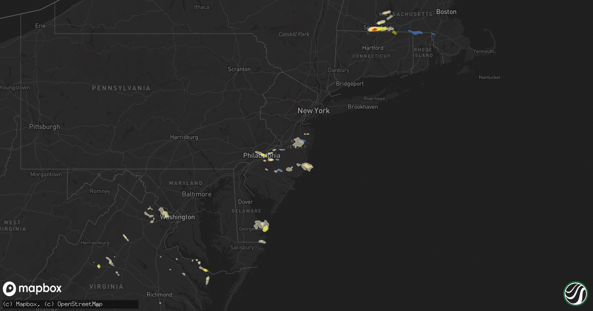
Hail Map in New Jersey on August 19, 2019
Get this storm
August 19 map
$229
one time, instant access
Download today. No call, no setup
Keep the $229
Bought the map and want the full workflow? Apply the entire $229 to a subscription within 7 days. None of it is wasted.
Every map, not just this one
This buys you this map. Subscription and you get every map we run, in the markets you choose from a few cities to whole states to nationwide. Plus real-time alerts the moment a storm fires.
Contact data
Name, contact info, occupancy, even credit band for addresses in the footprint. You go from where it hit to who to call.
Become the source they trust
Unlimited branding weather history reports on demand. You already have the documented answer ready for the property owner, and you are the one who showed up with it.
Property data and RoofTrace estimates
Pull up any address you have got, its value and the exact code rules for that jurisdiction, straight from One Click Code. Then RoofTrace estimates the squares, pitch, and roof value, priced the way you price.
Storm reports in New Jersey
New Jersey
| Date | Description |
|---|---|
| 08/19/20194:00 PM CDT | Delayed report. Barn blown over... Some tree damage and a large farm irrigation system blown over on spring road. Time estimated from radar. |
| 08/19/20193:38 PM CDT | Tree branches and power poles downed in the medford area according to mping. Time estimated from radar. |
| 08/19/20193:37 PM CDT | Tree down in wires with power outages near grassmere avenue and chestnut avenue. Time estimated from radar. |
| 08/19/20193:34 PM CDT | Mping report of large tree limbs snapped and power poles broken. Time estimated from radar. |
| 08/19/20193:24 PM CDT | Downed trees and wires near old farm road and sycamore avenue. Time estimated from radar. |
| 08/19/20193:20 PM CDT | A local report indicates 1.50 inch wind near 1 N ELLISBURG |
| 08/19/20193:14 PM CDT | Spotter estimated 50 kt wind gusts with storm passage. |
| 08/19/20193:13 PM CDT | Wind gusts between 61 and 73 mph. Time estimated from radar. |
| 08/19/20193:13 PM CDT | Downed trees and power lines near woodland avenue and linden avenue. Time estimated from radar. |
| 08/19/20193:13 PM CDT | Multiple trees down with street closures from pennsauken to the cherry hill mall. Power outages in this area... Which are leading to traffic disruptions as well. Time e |
| 08/19/20193:12 PM CDT | Measured at the columbus nj weathernet weather station. |
| 08/19/20193:10 PM CDT | Wires and some tree limbs down. Time estimated from radar. |
| 08/19/20193:04 PM CDT | Downed trees and power lines near hillside avenue and highland avenue. Time estimated from radar. |
| 08/19/20193:04 PM CDT | Tree down onto us 130 both directions approaching south of cr 616/cove road. One lane is closed. Time estimated from radar. |
| 08/19/20193:04 PM CDT | Large tree limbs down. Time estimated from radar. |
| 08/19/20193:03 PM CDT | Numerous trees down in the columbus area especially on jacksonville road. Time estimated from radar. |
| 08/19/20193:00 PM CDT | Trees and poles down on jacksonville road in westampton. Time estimated from radar. |
| 08/19/20193:00 PM CDT | Corrects previous tstm wnd dmg report from 1 n jacksonville. Trees and poles down near burlington jacksonville road in westampton. Time estimated from radar. |
| 08/19/20192:48 PM CDT | Large trees down in the roadway on creek road and also onto some houses between cox road and borton landing road in moorestown. Time estimated from radar. |
| 08/19/201912:34 PM CDT | A local report indicates 75 MPH wind near 2 SE FORKED RIVER |
| 08/19/201912:03 AM CDT | At 503 PM EDT, severe thunderstorms were located along a line extending from near Beachwood to near Clayton, moving southeast at 15 mph. HAZARD...60 mph wind gusts and quarter size hail. SOURCE...Radar indicated. IMPACT...Minor damage to vehicles is possible. Wind damage to roofs, siding, trees, and power lines is possible. Locations impacted include... Toms River, Barnegat, Glassboro, Hammonton, Beachwood, Clayton, Berlin, Tabernacle, Shamong, Buena, Egg Harbor City, Tuckerton, Seaside Heights, Weymouth, Chesilhurst, Surf City, Port Republic, Mantoloking, Elwood-Magnolia and Atsion.This includes the following highways... Atlantic City Expressway between mile markers 16 and 41. Garden State Parkway between mile markers 50 and 88. |
| 08/18/201911:54 PM CDT | At 454 PM EDT, severe thunderstorms were located along a line extending from Cedar Glen West to Adelphia, moving east at 30 mph. HAZARD...60 mph wind gusts and quarter size hail. SOURCE...Radar indicated. IMPACT...Minor damage to vehicles is possible. Wind damage to roofs, siding, trees, and power lines is possible. Locations impacted include... Toms River, Long Branch, Asbury Park, Lakewood, Howell, Tinton Falls, Red Bank, Manasquan, Point Pleasant Beach, Farmingdale, Mantoloking, Allenwood, East Freehold, West Freehold, Adelphia, Elberon, Brick Township, Collingwood Park, Leisure Village and Dover Beaches North.This includes the following highways... Garden State Parkway between mile markers 84 and 110. Interstate 195 in New Jersey between mile markers 23 and 34. |
| 08/18/201911:30 PM CDT | At 429 PM EDT, a cluster of severe thunderstorms was located from West Freehold to Bordentown, moving northeast at 20 mph. HAZARD...60 mph wind gusts and nickel size hail. SOURCE...Radar indicated. IMPACT...Damage to roofs, siding, trees, and power lines is possible. Locations impacted include... Toms River, Lakewood, Jackson, Manasquan, Point Pleasant Beach, Presidential Lakes Estates, Lakehurst, Allentown, Pemberton, Wrightstown, Leisure Village, Allenwood, Six Flags Theme Park, Cedar Glen West, Jacksons Mills, Georgetown, Cassville, Clarksburg, Vista Center and Crosswicks.This includes the following highways... Garden State Parkway between mile markers 89 and 96. Interstate 195 in New Jersey between mile markers 10 and 27. |
| 08/18/201911:21 PM CDT | At 420 PM EDT, a severe thunderstorm was located over Red Bank, or near Long Branch, moving east at 20 mph. HAZARD...60 mph wind gusts and quarter size hail. SOURCE...Radar indicated. IMPACT...Minor damage to vehicles is possible. Wind damage to roofs, siding, trees, and power lines is possible. Locations impacted include... Long Branch, Asbury Park, Sandy Hook, Middletown, Tinton Falls, Red Bank, Manasquan, Highlands, Point Pleasant Beach, Farmingdale, Allenwood, Elberon, Ramtown, Navesink, Collingwood Park, Lincroft, Eatontown, West Long Branch, Rumson and Little Silver.This includes the following highways... Garden State Parkway between mile markers 95 and 115. Interstate 195 in New Jersey between mile markers 31 and 34. |
| 08/18/201911:05 PM CDT | At 405 PM EDT, a severe thunderstorm was located over Barnegat, or 12 miles south of Toms River, and is nearly stationary. HAZARD...60 mph wind gusts and quarter size hail. SOURCE...Radar indicated. IMPACT...Minor damage to vehicles is possible. Wind damage to roofs, siding, trees, and power lines is possible. Locations impacted include... Barnegat, Brookville, Manahawkin, Ocean Acres and Waretown. This includes Garden State Parkway between mile markers 63 and 72. |
| 08/18/201910:58 PM CDT | At 358 PM EDT, a severe thunderstorm was located over West Freehold, or 16 miles south of New Brunswick, moving east at 10 mph. HAZARD...60 mph wind gusts and quarter size hail. SOURCE...Radar indicated. IMPACT...Minor damage to vehicles is possible. Wind damage to roofs, siding, trees, and power lines is possible. Locations impacted include... Howell, Marlboro, Manalapan, Holmdel, Farmingdale, Roosevelt, Adelphia, Yorketown, East Freehold, Lincroft, Freewood Acres, West Freehold, Clarksburg, Morganville, Freehold and Englishtown.This includes the following highways... Garden State Parkway near mile marker 112. Interstate 195 in New Jersey between mile markers 27 and 30. |
All States Impacted by Hail Map on August 19, 2019
Cities Impacted by Hail Map on August 19, 2019
- Afton, VA
- Greenwood, VA
- Bryson City, NC
- Scottsburg, VA
- Virgilina, VA
- Royston, GA
- Greensboro, NC
- Charlottesville, VA
- Earlysville, VA
- Free Union, VA
- Crozet, VA
- Humboldt, IA
- Hardy, IA
- Dickinson, ND
- Belfield, ND
- Fairfield, ND
- Pennsauken, NJ
- Cherry Hill, NJ
- Merchantville, NJ
- Camden, NJ
- Oberlin, KS
- Sperryville, VA
- Frankville, AL
- Millry, AL
- Chatom, AL
- Sherburn, MN
- Lee, NH
- Georgetown, MN
- Sainte Genevieve, MO
- Farmington, MO
- Hardaway, AL
- Tuskegee, AL
- Charlotte, NC
- Knightdale, NC
- Raleigh, NC
- Goldsboro, NC
- Lewes, DE
- Ramseur, NC
- Liberty, NC
- Staley, NC
- Perley, MN
- Borup, MN
- Hartwell, GA
- Oakton, VA
- Reston, VA
- Vienna, VA
- Devils Lake, ND
- Leeds, ND
- Argusville, ND
- Canton, GA
- Knoxville, AL
- Keystone, IA
- Elberon, IA
- Patoka, IL
- Verndale, MN
- Rehoboth Beach, DE
- Cove City, NC
- Old Fort, NC
- Springfield, MA
- Longmeadow, MA
- Feeding Hills, MA
- Agawam, MA
- Southwick, MA
- Kinston, NC
- Adairsville, GA
- Calhoun, GA
- Jeffers, MN
- Sanborn, MN
- Decatur, AL
- Eastchester, NY
- Tuckahoe, NY
- New Rochelle, NY
- Tuttle, ND
- Wannaska, MN
- Marion, NC
- Easley, SC
- Marshville, NC
- Peachland, NC
- Toledo, IA
- Dysart, IA
- Luzerne, IA
- Belle Plaine, IA
- Clutier, IA
- Geraldine, AL
- Liberty, SC
- Iowa City, IA
- Lone Tree, IA
- Riverside, IA
- Hills, IA
- Fairmont, MN
- Staples, MN
- Aldrich, MN
- Bertha, MN
- Trappe, MD
- Marion, AL
- Philadelphia, PA
- Vredenburgh, AL
- Franklin, AL
- Sterrett, AL
- Vincent, AL
- Woden, IA
- Britt, IA
- Titonka, IA
- Wesley, IA
- Vernon, CO
- Wray, CO
- Pell City, AL
- Vandiver, AL
- Fairmount, GA
- Manning, ND
- Barnegat, NJ
- Beach Haven, NJ
- Waretown, NJ
- Barnegat Light, NJ
- Belleville, IL
- Scott Air Force Base, IL
- O'Fallon, IL
- Freeburg, IL
- Mascoutah, IL
- West Springfield, MA
- Westfield, MA
- East Longmeadow, MA
- Hampden, MA
- Holly, CO
- Blanchard, ND
- Hatton, ND
- Mayville, ND
- Portland, ND
- Northwood, ND
- Windom, MN
- Fenton, IA
- Hendrum, MN
- Harwood, ND
- Gardner, ND
- Ada, MN
- Hobson, MT
- Trimont, MN
- Plains, KS
- Meade, KS
- Cleveland, GA
- Sautee Nacoochee, GA
- Montross, VA
- Pekin, ND
- Petersburg, ND
- Tolna, ND
- Niagara, ND
- Minnewaukan, ND
- Mcville, ND
- Penn, ND
- Churchs Ferry, ND
- Crary, ND
- Aneta, ND
- Larimore, ND
- Lakota, ND
- Michigan, ND
- York, ND
- Seneca, SC
- Woodville, MS
- Saint Stephens, AL
- Rome, GA
- Livermore, IA
- Lu Verne, IA
- Athens, GA
- Watkinsville, GA
- Bogart, GA
- Meherrin, VA
- Rugby, ND
- Georgetown, DE
- Harbeson, DE
- Milton, DE
- Freehold, NJ
- Jefferson, GA
- Summerville, GA
- Scottsville, VA
- Palmyra, VA
- Belchertown, MA
- Algona, IA
- Graettinger, IA
- Bancroft, IA
- Burt, IA
- Cylinder, IA
- Whittemore, IA
- Emmetsburg, IA
- Lone Rock, IA
- Stafford Springs, CT
- Mountain Lake, MN
- Bingham Lake, MN
- Livermore, ME
- Newbern, AL
- Kensett, IA
- Wilton, CT
- New Canaan, CT
- Denton, NC
- Lexington, NC
- Cuthbert, GA
- Chapin, SC
- Little Mountain, SC
- Louisburg, NC
- Cameron, NC
- Sanford, NC
- Section, AL
- Dutton, AL
- Nashua, IA
- Thor, IA
- Badger, IA
- Cumming, GA
- Alpharetta, GA
- Union Mills, NC
- Lake Lure, NC
- Fairfax, IA
- Amana, IA
- Herndon, KS
- Perham, MN
- New York Mills, MN
- Mocksville, NC
- Harmony, NC
- Ringsted, IA
- Wallingford, IA
- Estherville, IA
- Lookout Mountain, GA
- Flintstone, GA
- Menahga, MN
- Newhall, IA
- Watkins, IA
- Lesterville, MO
- Amherst, MA
- Buffalo Junction, VA
- South Boston, VA
- Fayette, AL
- Rutland, IA
- Dakota City, IA
- Eagle Grove, IA
- Goldfield, IA
- Sterling, VA
- McLean, VA
- Dunn Loring, VA
- Falls Church, VA
- Herndon, VA
- Great Falls, VA
- Frazee, MN
- Sebeka, MN
- Keysville, VA
- Green Bay, VA
- Wade, NC
- Linden, NC
- Corwith, IA
- Renwick, IA
- Upper Marlboro, MD
- Moorestown, NJ
- Riverton, NJ
- Maple Shade, NJ
- Wingate, NC
- Monroe, NC
- Marlton, NJ
- Voorhees, NJ
- Gary, MN
- Twin Valley, MN
- Terril, IA
- Pisgah Forest, NC
- Penrose, NC
- Brierfield, AL
- Greenville, IL
- Springfield, MN
- Comfrey, MN
- McCalla, AL
- Birmingham, AL
- Bessemer, AL
- Helena, AL
- Turpin, OK
- Milford, VA
- Walnut Hill, IL
- Centralia, IL
- Yadkinville, NC
- Clare, IA
- Starr, SC
- Iva, SC
- Traer, IA
- Piney Point, MD
- Heathsville, VA
- Northport, AL
- Berry, AL
- Kinards, SC
- Lancaster, MN
- Dewy Rose, GA
- Towner, ND
- Northwood, IA
- Lake Mills, IA
- Badger, MN
- Greenwich, CT
- Nisswa, MN
- Pine River, MN
- Pequot Lakes, MN
- Cushing, MN
- Pillager, MN
- Brainerd, MN
- Motley, MN
- Perryton, TX
- Victoria, VA
- Ackley, IA
- Iowa Falls, IA
- Alden, IA
- Lyerly, GA
- Winnebago, MN
- Delavan, MN
- Storden, MN
- Zebulon, NC
- Middlesex, NC
- Laurens, SC
- Mountville, SC
- Waterloo, SC
- Chicopee, MA
- Oconee, IL
- Lusby, MD
- Birch Tree, MO
- Kenbridge, VA
- Odin, IL
- Sandoval, IL
- Mulberry Grove, IL
- Keyesport, IL
- Carlyle, IL
- Vandalia, IL
- Smithboro, IL
- Hillsboro, ND
- Marengo, IA
- Newberry, SC
- Silverstreet, SC
- Jackson, MN
- Cheltenham, PA
- Merion Station, PA
- Wynnewood, PA
- Norway, IA
- Kenly, NC
- Sims, NC
- Chelsea, IA
- Walsh, CO
- Chantilly, VA
- Catharpin, VA
- Fort Dodge, IA
- Gilmore City, IA
- Vincent, IA
- Spirit Lake, IA
- Dolliver, IA
- Mars Hill, NC
- Buffalo Center, IA
- Thompson, IA
- Dunnell, MN
- Boston, VA
- Groveoak, AL
- West Jefferson, NC
- Bryant Pond, ME
- Hanlontown, IA
- Joice, IA
- Greenbush, MN
- Fayetteville, NC
- Travelers Rest, SC
- Taylors, SC
- Greer, SC
- Marietta, SC
- Trenton, IL
- Aviston, IL
- Highland, IL
- Leland, IA
- Millstone Township, NJ
- Cream Ridge, NJ
- Englishtown, NJ
- Jackson, NJ
- Howell, NJ
- Spring Hope, NC
- Elm City, NC
- Wilson, NC
- Lena, LA
- Flatwoods, LA
- Beaver City, NE
- Hendley, NE
- Pendleton, SC
- Teutopolis, IL
- Kodak, TN
- Sevierville, TN
- Armuchee, GA
- Kingston, OH
- Circleville, OH
- Snow Camp, NC
- Siler City, NC
- Adams, ND
- Spring Lake, NC
- Burkeville, VA
- Avoca, MN
- Gaylesville, AL
- Central, SC
- Fremont, NC
- Pikeville, NC
- Winder, GA
- Reva, VA
- Wendell, NC
- Robinson, ND
- Ninety Six, SC
- Chappells, SC
- Bailey, NC
- Montgomery, AL
- Baxter, MN
- Pocahontas, IL
- Fairdale, ND
- Millstadt, IL
- Smithton, IL
- Wing, ND
- Epping, NH
- Eutaw, AL
- Scarsdale, NY
- Mount Vernon, NY
- Larchmont, NY
- Pelham, NY
- Bronxville, NY
- Yonkers, NY
- Mamaroneck, NY
- Youngsville, NC
- Wake Forest, NC
- Rolesville, NC
- West Union, SC
- Walhalla, SC
- Westminster, SC
- Gladbrook, IA
- Eatontown, NJ
- Colts Neck, NJ
- Trion, GA
- Aldie, VA
- Middleburg, VA
- Leesburg, VA
- Gray Court, SC
- Morganton, NC
- Heron Lake, MN
- Monson, MA
- West Suffield, CT
- Trenton, NC
- Dover, NC
- Huntersville, NC
- Culpeper, VA
- Rocky Mount, NC
- Tarboro, NC
- Pollock, LA
- Welcome, MN
- Blair, SC
- Wadena, MN
- Ceylon, MN
- Lancaster, VA
- Weems, VA
- Kilmarnock, VA
- Caledonia, ND
- Blackstone, VA
- Hampden, ND
- Glassboro, NJ
- Sewell, NJ
- Williamstown, NJ
- Leeds, ME
- Hamptonville, NC
- Forest City, NC
- Ellenboro, NC
- Mooresboro, NC
- Clemson, SC
- Willingboro, NJ
- Burlington, NJ
- Vernon, AL
- Sulligent, AL
- Shelby, NC
- Osage, MN
- Detroit Lakes, MN
- Wheatland, ND
- Casselton, ND
- Saint Peter, IL
- Ware, MA
- Wilbraham, MA
- Wales, MA
- Stewardson, IL
- Shumway, IL
- Plainville, GA
- Effingham, IL
- Dundas, VA
- Cedar Rapids, IA
- Clarksville, VA
- Runnemede, NJ
- Hague, VA
- Chesnee, SC
- Indian Orchard, MA
- Ludlow, MA
- Greenwood, ME
- Radcliffe, IA
- Ellsworth, IA
- Munich, ND
- Ellington, MO
- Kennedy, AL
- Millport, AL
- Seaside Park, NJ
- Forked River, NJ
- Talking Rock, GA
- Jasper, GA
- Ulen, MN
- Waubun, MN
- Spruce Pine, NC
- Moundville, AL
- Milford, IA
- Mchenry, ND
- Durham, NH
- Linton, IN
- Fairview Heights, IL
- Lebanon, IL
- Waterloo, IL
- Robbins, NC
- Nashville, NC
- Van Horne, IA
- Garrison, IA
- Garwin, IA
- Reinbeck, IA
- Hudson, IA
- Buckingham, IA
- Hubbard, IA
- Grace City, ND
- Catawba, NC
- Claremont, NC
- Westport, CT
- Weston, CT
- Fairfield, CT
- Plant City, FL
- Bunnlevel, NC
- Hammonton, NJ
- Thomaston, AL
- Uniontown, AL
- Redding, CT
- Easton, CT
- Idalia, CO
- Chatsworth, NJ
- Vincentown, NJ
- Turner, ME
- Buckfield, ME
- Ironton, MO
- Rockwell, IA
- Felton, MN
- Grandin, ND
- Ogema, MN
- Arthur, ND
- Selbyville, DE
- Alberta, VA
- Tappahannock, VA
- Haymarket, VA
- Andrews, NC
- Bala Cynwyd, PA
- Narberth, PA
- Havertown, PA
- Collingswood, NJ
- Ardmore, PA
- Statesville, NC
- Newton, NC
- Appomattox, VA
- Orlando, FL
- Windermere, FL
- Wayne, ME
- Mount Kisco, NY
- Armonk, NY
- Gaffney, SC
- Augusta, ME
- Kinsale, VA
- West Paris, ME
- Dawsonville, GA
- Marshall, MN
- Cottonwood, MN
- Cave Spring, GA
- Swea City, IA
- Carlisle, SC
- Woolstock, IA
- Ocean City, MD
- Haddonfield, NJ
- Anderson, SC
- Scotland, MD
- Glendora, NJ
- Woodbury, NJ
- Bellmawr, NJ
- Westville, NJ
- Barrington, NJ
- Westbrook, MN
- Butterfield, MN
- Lamberton, MN
- Stantonsburg, NC
- Saint James, MN
- Alma, IL
- Frankford, DE
- Bishopville, MD
- Pittsboro, NC
- Knoxville, TN
- Dix, IL
- Mount Vernon, IL
- Readfield, ME
- Manchester, ME
- Winthrop, ME
- Bennett, NC
- Coffeeville, AL
- Highlands, NC
- Ruckersville, VA
- Pickens, SC
- Hodges, SC
- Pope Army Airfield, NC
- Fort Bragg, NC
- Colonial Beach, VA
- The Plains, VA
- Waleska, GA
- Woodford, VA
- Deep Run, NC
- Lottsburg, VA
- Callao, VA
- Caseyville, IL
- Collinsville, IL
- Troy, IL
- Gainesville, GA
- Athens, AL
- Tanner, AL
- Gainesville, VA
- Bristow, VA
- Manassas, VA
- Greenwood, SC
- Bode, IA
- Ruthven, IA
- Okoboji, IA
- Armstrong, IA
- Arnolds Park, IA
- West Bend, IA
- Beecher City, IL
- Alpha, MN
- Darfur, MN
- Fulda, MN
- Waynesboro, VA
- Lewisville, NC
- Clemmons, NC
- Edmore, ND
- Melbourne, AR
- Lawndale, NC
- Lakota, IA
- Buckatunna, MS
- State Line, MS
- Derry, NH
- Austinville, VA
- Max Meadows, VA
- Chickamauga, GA
- Akron, AL
- Annapolis, MO
- Vulcan, MO
- Forgan, OK
- Advance, NC
- Union Springs, AL
- Browerville, MN
- Hewitt, MN
- Bluffton, MN
- Hatchechubbee, AL
- Madison, GA
- Chester, VA
- Richmond, VA
- Asheboro, NC
- Seagrove, NC
- New Straitsville, OH
- Suffield, CT
- Mahnomen, MN
- Callaway, MN
- Park Rapids, MN
- Walker, MN
- Rochert, MN
- White Earth, MN
- Ponsford, MN
- Laporte, MN
- Hackensack, MN
- Naytahwaush, MN
- Lake George, MN
- Backus, MN
- Nevis, MN
- Bagley, MN
- Akeley, MN
- Fosston, MN
- Bejou, MN
- Fort Ripley, MN
- Lookout Mountain, TN
- Remsen, IA
- Marcus, IA
- Clarion, IA
- Gray, IA
- Templeton, IA
- Audubon, IA
- Kirkman, IA
- Defiance, IA
- Harlan, IA
- Manning, IA
- Manilla, IA
- Irwin, IA
- Auburn, IA
- Lytton, IA
- Lake City, IA
- Vail, IA
- Breda, IA
- Westside, IA
- Carroll, IA
- Rockwell City, IA
- Arcadia, IA
- Quimby, IA
- Cherokee, IA
- Cleghorn, IA
- Scranton, IA
- Glidden, IA
- Ralston, IA
- Coon Rapids, IA
- Earlham, IA
- Van Meter, IA
- Winterset, IA
- Uxbridge, MA
- Slatersville, RI
- Harrisville, RI
- Douglas, MA
- Webster, MA
- Dudley, MA
- North Smithfield, RI
- North Grosvenordale, CT
- Pascoag, RI
- Thompson, CT
- Plainville, MA
- Attleboro Falls, MA
- North Attleboro, MA
- Grass Range, MT
- Lewistown, MT
- Gloucester City, NJ
- Bordentown, NJ
- Columbus, NJ
- Jobstown, NJ
- Wrightstown, NJ
- Medford, NJ
- Farmingdale, NJ
- Waterford Works, NJ
- Knox, ND
- Wolford, ND
- Bowdon, ND
- Buxton, ND
- Strawberry Plains, TN
- Hornick, IA
- Smithland, IA
- Earling, IA
- Panama, IA
- Westphalia, IA
- Danbury, IA
- Anthon, IA
- Battle Creek, IA
- Oto, IA
- Holstein, IA
- Cushing, IA
- Galva, IA
- Washta, IA
- Correctionville, IA
- Kimballton, IA
- Chillicothe, IA
- Milo, IA
- What Cheer, IA
- Packwood, IA
- Ackworth, IA
- Sigourney, IA
- Eldon, IA
- Ollie, IA
- Floris, IA
- Saint Charles, IA
- Melcher Dallas, IA
- Chariton, IA
- New Sharon, IA
- Hayesville, IA
- Eddyville, IA
- Hedrick, IA
- Martensdale, IA
- Cumming, IA
- Udell, IA
- University Park, IA
- Prole, IA
- Lacona, IA
- Agency, IA
- Fairfield, IA
- Williamson, IA
- Indianola, IA
- Bussey, IA
- Pleasantville, IA
- Tracy, IA
- Rose Hill, IA
- Norwalk, IA
- Drakesville, IA
- Woodburn, IA
- Unionville, IA
- Osceola, IA
- Hamilton, IA
- Moravia, IA
- Liberty Center, IA
- Batavia, IA
- Fremont, IA
- New Virginia, IA
- Blakesburg, IA
- Russell, IA
- Bloomfield, IA
- Leighton, IA
- Melrose, IA
- Albia, IA
- Martinsburg, IA
- Bevington, IA
- Beacon, IA
- Cedar, IA
- Knoxville, IA
- Lovilia, IA
- Saint Marys, IA
- Lucas, IA
- Kirkville, IA
- Delta, IA
- Centerville, IA
- Richland, IA
- Oskaloosa, IA
- Ottumwa, IA
- Columbia, IA
- Cambridge, IA
- Maxwell, IA
- Mingo, IA
- Collins, IA
- Adair, IA
- Casey, IA
- Stuart, IA
- Exira, IA
- Redfield, IA
- Menlo, IA
- Panora, IA
- Dexter, IA
- Adel, IA
- Guthrie Center, IA
- Hamlin, IA
- Linden, IA
- West Des Moines, IA
- Berwick, IA
- Johnston, IA
- Mitchellville, IA
- Newton, IA
- Prairie City, IA
- Otley, IA
- Reasnor, IA
- Swan, IA
- Altoona, IA
- Lynnville, IA
- Des Moines, IA
- Killduff, IA
- Carlisle, IA
- Harvey, IA
- Sully, IA
- Runnells, IA
- Elkhart, IA
- Montezuma, IA
- Bondurant, IA
- Hartford, IA
- Pleasant Hill, IA
- Ankeny, IA
- Searsboro, IA
- Monroe, IA
- Grinnell, IA
- Urbandale, IA
- Pella, IA
- Colfax, IA
- Tuscaloosa, AL
- Bantry, ND
- Brocket, ND
- Southport, CT
- Bridgeport, CT
- White Oak, NC
- Madbury, NH
- Nottingham, NH
- Dover, NH
- Elkhart, KS


