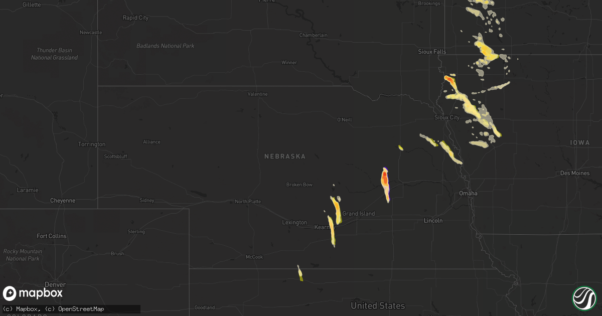
Hail Map in Nebraska on August 18, 2022
Get this storm
August 18 map
$229
one time, instant access
Download today. No call, no setup
Keep the $229
Bought the map and want the full workflow? Apply the entire $229 to a subscription within 7 days. None of it is wasted.
Every map, not just this one
This buys you this map. Subscription and you get every map we run, in the markets you choose from a few cities to whole states to nationwide. Plus real-time alerts the moment a storm fires.
Contact data
Name, contact info, occupancy, even credit band for addresses in the footprint. You go from where it hit to who to call.
Become the source they trust
Unlimited branding weather history reports on demand. You already have the documented answer ready for the property owner, and you are the one who showed up with it.
Property data and RoofTrace estimates
Pull up any address you have got, its value and the exact code rules for that jurisdiction, straight from One Click Code. Then RoofTrace estimates the squares, pitch, and roof value, priced the way you price.
Storm reports in Nebraska
Nebraska
| Date | Description |
|---|---|
| 08/18/20226:55 PM CDT | Pea to quarter sized hail. |
| 08/18/20226:40 PM CDT | Facebook report. |
| 08/18/20226:29 PM CDT | Pea to golf ball sized hail. |
| 08/18/20226:22 PM CDT | Still hailing in genoa with video of up to baseball size hail on facebook. |
| 08/18/20226:13 PM CDT | Quarter sized hail falling over hwy 30. Cars pulled off on the side of the road. |
| 08/18/20226:13 PM CDT | Facebook picture. Time estimated from radar. |
| 08/18/20226:12 PM CDT | Facebook report and video. Time from radar. |
| 08/18/20226:10 PM CDT | A local report indicates 1.00 inch wind near 2 S PENDER |
| 08/18/20226:09 PM CDT | A local report indicates 2.75 inch wind near 2 N GENOA |
| 08/18/20226:06 PM CDT | Quarter to golf ball sized hail. |
| 08/18/20225:56 PM CDT | A local report indicates 2.75 inch wind near 6 E SAINT EDWARD |
| 08/18/20225:51 PM CDT | Report from mping: quarter (1. |
| 08/18/20225:51 PM CDT | Dime to quarter size hail. Time from radar. |
| 08/18/20225:51 PM CDT | Report from mping: quarter |
| 08/18/20225:32 PM CDT | Facebook report of continued quarter size hail. |
| 08/18/20225:27 PM CDT | Facebook report. Time estimated from radar. |
| 08/18/20225:24 PM CDT | Window shattered out of car. Time estimated from radar. |
| 08/18/20225:24 PM CDT | Facebook picture of hail with quarter for comparison. Reported that it hailed for 30 minutes at this location. Time estimated from radar. |
| 08/18/20225:16 PM CDT | Video of hail... With some stones as large as quarters. |
| 08/18/20225:08 PM CDT | Facebook video of what appears to be golf ball size hail. |
| 08/18/20225:03 PM CDT | Picture on facebook. Time estimated from radar. |
| 08/18/20225:15 AM CDT | One public report of hail up to quarter size. Several reports within 1 mile of this location reported pea up to half inch hail. |
| 08/18/20222:11 AM CDT | At 710 PM CDT, a severe thunderstorm was located near Stromsburg, or 20 miles north of York, moving south at 20 mph. HAZARD...60 mph wind gusts and quarter size hail. SOURCE...Radar indicated. IMPACT...Hail damage to vehicles is expected. Expect wind damage to roofs, siding, and trees. This severe thunderstorm will be near... Stromsburg around 720 PM CDT. Polk around 725 PM CDT.Other locations in the path of this severe thunderstorm includeBenedict. |
| 08/18/20221:29 AM CDT | At 627 PM CDT, a severe thunderstorm was located near Genoa, or 19 miles west of Columbus, moving south at 20 mph. THIS IS A DESTRUCTIVE STORM FOR Genoa and Silver Creek! HAZARD...Baseball size hail and 60 mph wind gusts. SOURCE...Trained weather spotters. Baseball size hail has been reported in Genoa. IMPACT...People and animals outdoors will be severely injured. Expect shattered windows, extensive damage to roofs, siding, and vehicles. This severe thunderstorm will be near... Silver Creek around 645 PM CDT.Other locations in the path of this severe thunderstorm includeClarks and Osceola. |
| 08/18/20221:23 AM CDT | At 623 PM CDT, a severe thunderstorm was located 7 miles south of Gibbon, or 10 miles east of Kearney, moving south at 20 mph. HAZARD...Ping pong ball size hail and 60 mph wind gusts. SOURCE...Trained weather spotters. IMPACT...People and animals outdoors will be injured. Expect hail damage to roofs, siding, windows, and vehicles. Expect wind damage to roofs, siding, and trees. This severe thunderstorm will be near... Heartwell around 640 PM CDT.Other locations in the path of this severe thunderstorm includeMinden and Norman.This includes Interstate 80 between mile markers 277 and 286. |
| 08/18/20221:06 AM CDT | At 606 PM CDT, a severe thunderstorm was located over Pender, or 17 miles southeast of Wayne, moving southeast at 15 mph. HAZARD...60 mph wind gusts and quarter size hail. SOURCE...Emergency management. IMPACT...Hail damage to vehicles is expected. Expect wind damage to roofs, siding, and trees. This severe thunderstorm will be near... Pender around 610 PM CDT.Other locations in the path of this severe thunderstorm includeBancroft and Rosalie. |
| 08/18/202212:53 AM CDT | At 552 PM CDT, a severe thunderstorm was located near Genoa, or 21 miles west of Columbus, moving south at 25 mph. HAZARD...60 mph wind gusts and quarter size hail. SOURCE...Radar indicated. IMPACT...Hail damage to vehicles is expected. Expect wind damage to roofs, siding, and trees. This severe thunderstorm will be near... Genoa around 605 PM CDT.Other locations in the path of this severe thunderstorm includeSilver Creek. |
| 08/18/202212:46 AM CDT | At 546 PM CDT, a severe thunderstorm was located 8 miles northwest of Gibbon, or 11 miles northeast of Kearney, moving south at 20 mph. HAZARD...60 mph wind gusts and quarter size hail. SOURCE...Radar indicated. IMPACT...Hail damage to vehicles is expected. Expect wind damage to roofs, siding, and trees. This severe thunderstorm will be near... Gibbon around 605 PM CDT.This includes Interstate 80 between mile markers 276 and 288. |
| 08/18/202212:42 AM CDT | At 542 PM CDT, a severe thunderstorm was located 5 miles south of Lindsay, or 16 miles east of Albion, moving southeast at 20 mph. This storm has produced hail up to nickel size. HAZARD...60 mph wind gusts and quarter size hail. SOURCE...Radar indicated. IMPACT...Hail damage to vehicles is expected. Expect wind damage to roofs, siding, and trees. Locations impacted include... Platte Center, Monroe, Duncan and Lakeview. |
| 08/18/202212:35 AM CDT | At 534 PM CDT, a severe thunderstorm was located 4 miles south of Lindsay, or 15 miles east of Albion, moving southeast at 25 mph. HAZARD...60 mph wind gusts and quarter size hail. SOURCE...Radar indicated. IMPACT...Hail damage to vehicles is expected. Expect wind damage to roofs, siding, and trees. Locations impacted include... Platte Center, Monroe and Duncan. |
| 08/18/202212:27 AM CDT | At 527 PM CDT, a severe thunderstorm was located 8 miles southwest of Cairo, or 20 miles west of Grand Island, moving south at 20 mph. HAZARD...60 mph wind gusts and half dollar size hail. SOURCE...Radar indicated. IMPACT...Hail damage to vehicles is expected. Expect wind damage to roofs, siding, and trees. Locations impacted include... Wood River and Shelton.This includes Interstate 80 between mile markers 286 and 303. |
| 08/18/202212:16 AM CDT | At 516 PM CDT, a severe thunderstorm was located near Wayne, moving southeast at 30 mph. HAZARD...60 mph wind gusts and half dollar size hail. SOURCE...Radar indicated. IMPACT...Hail damage to vehicles is expected. Expect wind damage to roofs, siding, and trees. This severe thunderstorm will be near... Wakefield around 520 PM CDT.Other locations in the path of this severe thunderstorm includeThurston and Pender. |
| 08/17/202211:42 PM CDT | At 442 PM CDT, a severe thunderstorm was located near Rockville, or 31 miles northwest of Grand Island, moving southeast at 25 mph. HAZARD...60 mph wind gusts and quarter size hail. SOURCE...Radar indicated. IMPACT...Hail damage to vehicles is expected. Expect wind damage to roofs, siding, and trees. This severe thunderstorm will be near... Rockville around 450 PM CDT. Ravenna around 455 PM CDT. Boelus around 500 PM CDT. |
| 08/17/20228:15 PM CDT | A local report indicates 1.00 inch wind near 5 SW DECATUR |
| 08/17/20227:12 PM CDT | A local report indicates 1.50 inch wind near 6 W OSCEOLA |
All States Impacted by Hail Map on August 18, 2022
Cities Impacted by Hail Map on August 18, 2022
- Bayfield, WI
- Spencer, IA
- Dickens, IA
- Sibley, IA
- Ashton, IA
- Sheldon, IA
- Sanborn, IA
- Cooperstown, ND
- Hannaford, ND
- Kellogg, MN
- Caldwell, TX
- Rock Valley, IA
- Duson, LA
- Scott, LA
- Rayne, LA
- Walnut Grove, MN
- Beaumont, TX
- Currie, MN
- Revere, MN
- Hawthorne, FL
- Geneva, FL
- Oviedo, FL
- Vidor, TX
- Orange, TX
- Gibbon, NE
- Rockville, NE
- Loup City, NE
- Shelton, NE
- Ravenna, NE
- Rockdale, TX
- Cokato, MN
- Dassel, MN
- Lampasas, TX
- Columbia, SD
- Groton, SD
- Bath, SD
- Wayne, NE
- Bancroft, NE
- Pender, NE
- Wakefield, NE
- Hull, TX
- Palm City, FL
- Lake Placid, FL
- Upland, NE
- Minden, NE
- Kearney, NE
- Pleasanton, NE
- Estherville, IA
- Galesville, WI
- Trempealeau, WI
- Dodge, WI
- George, IA
- Fellsmere, FL
- Palm Bay, FL
- El Campo, TX
- Balaton, MN
- Liberty, TX
- Marcus, IA
- Hartley, IA
- Battle Creek, IA
- Ida Grove, IA
- Schleswig, IA
- Danbury, IA
- Stanton, NE
- Norfolk, NE
- Cleghorn, IA
- Anthon, IA
- Redwood Falls, MN
- Wabasso, MN
- Ghent, MN
- Milroy, MN
- Ivanhoe, MN
- Marshall, MN
- Minneota, MN
- Tracy, MN
- Lucan, MN
- Porter, MN
- Taunton, MN
- Vesta, MN
- Mapleton, IA
- Jeffers, MN
- Tonopah, AZ
- Cherokee, IA
- Buckeye, AZ
- Pekin, ND
- Edgerton, MN
- Harris, IA
- Worthington, MN
- Melvin, IA
- Ocheyedan, IA
- Bigelow, MN
- Reading, MN
- Lake Park, IA
- Brewster, MN
- Lakefield, MN
- Round Lake, MN
- Wilmont, MN
- Rushmore, MN
- Fulda, MN
- Soldier, IA
- Ute, IA
- Charter Oak, IA
- Denison, IA
- Castana, IA
- Dow City, IA
- Woolwine, VA
- Gorham, KS
- Westbrook, MN
- Avoca, MN
- Milford, IA
- Ashton, NE
- White Oak, GA
- Greenville, IA
- Sioux Rapids, IA
- Royal, IA
- Linn Grove, IA
- Peterson, IA
- Le Mars, IA
- Maurice, IA
- Primghar, IA
- Sutherland, IA
- Jackson, MN
- Lexington, TX
- Elgin, TX
- Berlin, ND
- Dickey, ND
- Heron Lake, MN
- Windom, MN
- Hutchinson, MN
- Russell, MN
- Lynd, MN
- Spirit Lake, IA
- Eunice, LA
- Reddick, FL
- Williston, FL
- Lamberton, MN
- Virginia City, NV
- Christmas, FL
- Houghton, SD
- Sugar Land, TX
- Richmond, TX
- River Falls, WI
- Prescott, WI
- Hastings, MN
- Fountain City, WI
- Remsen, IA
- Glen Saint Mary, FL
- Kiron, IA
- Deloit, IA
- Spring, TX
- Hinton, IA
- Merrill, IA
- Seligman, AZ
- Iola, TX
- Bryan, TX
- Clarkfield, MN
- Cottonwood, MN
- Palm Beach Gardens, FL
- Loxahatchee, FL
- West Palm Beach, FL
- Binford, ND
- Mcville, ND
- Paullina, IA
- Larrabee, IA
- Brandt, SD
- Hendricks, MN
- Astoria, SD
- Canby, MN
- Hager City, WI
- Ellsworth, WI
- Beldenville, WI
- Alpine, TX
- Moscow, TX
- Livingston, TX
- Slayton, MN
- Garvin, MN
- Kirkland, AZ
- Kirbyville, TX
- Jasper, TX
- Kingwood, TX
- Warren, TX
- Genoa, NE
- Saint Edward, NE
- Quimby, IA
- Kenedy, TX
- Washta, IA
- Storden, MN
- Pearland, TX
- Lindsay, NE
- Stromsburg, NE
- Newman Grove, NE
- Osceola, NE
- Clarks, NE
- Silver Creek, NE
- Arthur, IA
- Odebolt, IA
- Tekamah, NE
- Rosalie, NE
- Decatur, NE
- Craig, NE
- Lyons, NE
- Long Island, KS
- Prairie View, KS
- Almena, KS
- Sioux Center, IA
- Hawarden, IA
- Pierson, IA
- Crowley, LA
- Mondamin, IA
- Okoboji, IA
- Houston, TX
- Ireton, IA
- Hudson, SD
- Kingsley, IA
- Cushing, IA
- Correctionville, IA
- Dakota, MN
- Holstein, IA
- Bird Island, MN
- Hector, MN
- Beaver City, NE
- Basile, LA
- Oyens, IA
- Akron, IA
- Brunsville, IA
- Galva, IA
- Aurelia, IA
- Manvel, TX
- Rosharon, TX
- Cuero, TX
- Chiefland, FL
- Blythe, CA
- Moville, IA
- Stamford, NE
- Marquette, MI
- Gwinn, MI
- Kingman, AZ
- Oakland, NE
- Boelus, NE
- Goliad, TX
- Missouri City, TX
- Edna, TX
- Citra, FL
- Yoakum, TX
- Cosmos, MN
- Buffalo Lake, MN
- Olivia, MN
- Wellton, AZ
- Arcadia, WI
- Thorndale, TX
- Winona, MN
- Houston, MN
- Sour Lake, TX
- Buffalo, MN
- Adrian, MN
- Jacksonville, FL
- Devers, TX
- Silsbee, TX
- Fred, TX
- Spurger, TX
- Wood River, NE
- Walthill, NE


