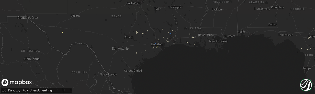
Hail Map on August 18, 2022
The weather event on August 18, 2022 includes Hail and Wind maps. 16 states and 262 cities were impacted and suffered possible damage. The total estimated number of properties impacted is 25,002.
Want more than just the map?
Turn this storm into a full workflow.
- Owner + property data so you know who to knock
- OnDemand branded weather history reports to win the "did we even have hail?" argument
- RoofTrace estimate so reps stop guessing numbers at the door
Bought this map? Upgrade within 7 days and we'll credit the $230. (10-15 min setup call)
Hail
Wind
25,002
Estimated number of impacted properties by a 1.00" hail or larger3,714
Estimated number of impacted properties by a 1.75" hail or larger2,326
Estimated number of impacted properties by a 2.50" hail or largerStates Impacted by Hail Map on August 18, 2022
Storm reports
Louisiana
| Date | Description |
|---|---|
| 08/18/20225:05 PM CDT | Pictures of a roof blown off with tin and wood debris scattered down wind. |
Nebraska
| Date | Description |
|---|---|
| 08/18/20226:55 PM CDT | Pea to quarter sized hail. |
| 08/18/20226:40 PM CDT | Facebook report. |
| 08/18/20226:29 PM CDT | Pea to golf ball sized hail. |
| 08/18/20226:22 PM CDT | Still hailing in genoa with video of up to baseball size hail on facebook. |
| 08/18/20226:13 PM CDT | Facebook picture. Time estimated from radar. |
| 08/18/20226:13 PM CDT | Quarter sized hail falling over hwy 30. Cars pulled off on the side of the road. |
| 08/18/20226:12 PM CDT | Facebook report and video. Time from radar. |
| 08/18/20226:10 PM CDT | A local report indicates 1.00 inch wind near 2 S PENDER |
| 08/18/20226:09 PM CDT | A local report indicates 2.75 inch wind near 2 N GENOA |
| 08/18/20226:06 PM CDT | Quarter to golf ball sized hail. |
| 08/18/20225:56 PM CDT | A local report indicates 2.75 inch wind near 6 E SAINT EDWARD |
| 08/18/20225:51 PM CDT | Report from mping: quarter (1. |
| 08/18/20225:51 PM CDT | Dime to quarter size hail. Time from radar. |
| 08/18/20225:51 PM CDT | Report from mping: quarter |
| 08/18/20225:32 PM CDT | Facebook report of continued quarter size hail. |
| 08/18/20225:27 PM CDT | Facebook report. Time estimated from radar. |
| 08/18/20225:24 PM CDT | Facebook picture of hail with quarter for comparison. Reported that it hailed for 30 minutes at this location. Time estimated from radar. |
| 08/18/20225:24 PM CDT | Window shattered out of car. Time estimated from radar. |
| 08/18/20225:16 PM CDT | Video of hail... With some stones as large as quarters. |
| 08/18/20225:08 PM CDT | Facebook video of what appears to be golf ball size hail. |
| 08/18/20225:03 PM CDT | Picture on facebook. Time estimated from radar. |
| 08/18/20225:15 AM CDT | One public report of hail up to quarter size. Several reports within 1 mile of this location reported pea up to half inch hail. |
| 08/18/20222:11 AM CDT | At 710 PM CDT, a severe thunderstorm was located near Stromsburg, or 20 miles north of York, moving south at 20 mph. HAZARD...60 mph wind gusts and quarter size hail. SOURCE...Radar indicated. IMPACT...Hail damage to vehicles is expected. Expect wind damage to roofs, siding, and trees. This severe thunderstorm will be near... Stromsburg around 720 PM CDT. Polk around 725 PM CDT.Other locations in the path of this severe thunderstorm includeBenedict. |
| 08/18/20221:29 AM CDT | At 627 PM CDT, a severe thunderstorm was located near Genoa, or 19 miles west of Columbus, moving south at 20 mph. THIS IS A DESTRUCTIVE STORM FOR Genoa and Silver Creek! HAZARD...Baseball size hail and 60 mph wind gusts. SOURCE...Trained weather spotters. Baseball size hail has been reported in Genoa. IMPACT...People and animals outdoors will be severely injured. Expect shattered windows, extensive damage to roofs, siding, and vehicles. This severe thunderstorm will be near... Silver Creek around 645 PM CDT.Other locations in the path of this severe thunderstorm includeClarks and Osceola. |
| 08/18/20221:23 AM CDT | At 623 PM CDT, a severe thunderstorm was located 7 miles south of Gibbon, or 10 miles east of Kearney, moving south at 20 mph. HAZARD...Ping pong ball size hail and 60 mph wind gusts. SOURCE...Trained weather spotters. IMPACT...People and animals outdoors will be injured. Expect hail damage to roofs, siding, windows, and vehicles. Expect wind damage to roofs, siding, and trees. This severe thunderstorm will be near... Heartwell around 640 PM CDT.Other locations in the path of this severe thunderstorm includeMinden and Norman.This includes Interstate 80 between mile markers 277 and 286. |
| 08/18/20221:06 AM CDT | At 606 PM CDT, a severe thunderstorm was located over Pender, or 17 miles southeast of Wayne, moving southeast at 15 mph. HAZARD...60 mph wind gusts and quarter size hail. SOURCE...Emergency management. IMPACT...Hail damage to vehicles is expected. Expect wind damage to roofs, siding, and trees. This severe thunderstorm will be near... Pender around 610 PM CDT.Other locations in the path of this severe thunderstorm includeBancroft and Rosalie. |
| 08/18/202212:53 AM CDT | At 552 PM CDT, a severe thunderstorm was located near Genoa, or 21 miles west of Columbus, moving south at 25 mph. HAZARD...60 mph wind gusts and quarter size hail. SOURCE...Radar indicated. IMPACT...Hail damage to vehicles is expected. Expect wind damage to roofs, siding, and trees. This severe thunderstorm will be near... Genoa around 605 PM CDT.Other locations in the path of this severe thunderstorm includeSilver Creek. |
| 08/18/202212:46 AM CDT | At 546 PM CDT, a severe thunderstorm was located 8 miles northwest of Gibbon, or 11 miles northeast of Kearney, moving south at 20 mph. HAZARD...60 mph wind gusts and quarter size hail. SOURCE...Radar indicated. IMPACT...Hail damage to vehicles is expected. Expect wind damage to roofs, siding, and trees. This severe thunderstorm will be near... Gibbon around 605 PM CDT.This includes Interstate 80 between mile markers 276 and 288. |
| 08/18/202212:42 AM CDT | At 542 PM CDT, a severe thunderstorm was located 5 miles south of Lindsay, or 16 miles east of Albion, moving southeast at 20 mph. This storm has produced hail up to nickel size. HAZARD...60 mph wind gusts and quarter size hail. SOURCE...Radar indicated. IMPACT...Hail damage to vehicles is expected. Expect wind damage to roofs, siding, and trees. Locations impacted include... Platte Center, Monroe, Duncan and Lakeview. |
| 08/18/202212:35 AM CDT | At 534 PM CDT, a severe thunderstorm was located 4 miles south of Lindsay, or 15 miles east of Albion, moving southeast at 25 mph. HAZARD...60 mph wind gusts and quarter size hail. SOURCE...Radar indicated. IMPACT...Hail damage to vehicles is expected. Expect wind damage to roofs, siding, and trees. Locations impacted include... Platte Center, Monroe and Duncan. |
| 08/18/202212:27 AM CDT | At 527 PM CDT, a severe thunderstorm was located 8 miles southwest of Cairo, or 20 miles west of Grand Island, moving south at 20 mph. HAZARD...60 mph wind gusts and half dollar size hail. SOURCE...Radar indicated. IMPACT...Hail damage to vehicles is expected. Expect wind damage to roofs, siding, and trees. Locations impacted include... Wood River and Shelton.This includes Interstate 80 between mile markers 286 and 303. |
| 08/18/202212:16 AM CDT | At 516 PM CDT, a severe thunderstorm was located near Wayne, moving southeast at 30 mph. HAZARD...60 mph wind gusts and half dollar size hail. SOURCE...Radar indicated. IMPACT...Hail damage to vehicles is expected. Expect wind damage to roofs, siding, and trees. This severe thunderstorm will be near... Wakefield around 520 PM CDT.Other locations in the path of this severe thunderstorm includeThurston and Pender. |
| 08/17/202211:42 PM CDT | At 442 PM CDT, a severe thunderstorm was located near Rockville, or 31 miles northwest of Grand Island, moving southeast at 25 mph. HAZARD...60 mph wind gusts and quarter size hail. SOURCE...Radar indicated. IMPACT...Hail damage to vehicles is expected. Expect wind damage to roofs, siding, and trees. This severe thunderstorm will be near... Rockville around 450 PM CDT. Ravenna around 455 PM CDT. Boelus around 500 PM CDT. |
| 08/17/20228:15 PM CDT | A local report indicates 1.00 inch wind near 5 SW DECATUR |
| 08/17/20227:12 PM CDT | A local report indicates 1.50 inch wind near 6 W OSCEOLA |
South Dakota
| Date | Description |
|---|---|
| 08/18/20225:15 PM CDT | Photo on facebook just a little larger than a quarter. Time estimated. |
| 08/17/202211:56 PM CDT | At 455 PM CDT, a severe thunderstorm was located near Columbia, or 12 miles northwest of Groton, moving south at 30 mph. HAZARD...60 mph wind gusts and quarter size hail. SOURCE...Radar indicated. IMPACT...Hail damage to vehicles is expected. Expect wind damage to roofs, siding, and trees. This severe thunderstorm will be near... Tacoma Park around 500 PM CDT. Putney around 505 PM CDT.Other locations in the path of this severe thunderstorm includeGroton. |
Florida
| Date | Description |
|---|---|
| 08/18/20224:35 PM CDT | Report of tree down on a powerline. |
| 08/18/20223:00 PM CDT | Report of power lines down cause by thunderstorm winds. |
| 08/18/20222:25 PM CDT | Report of tree down in parking lot of hca orange park hospital across 3 vehicles. |
| 08/18/20221:25 PM CDT | Report of trees down caused by thunderstorm winds. |
| 08/18/202212:38 PM CDT | Duke energy reported damage to utility equipment from downed trees and limbs along nw 165th street. |
| 08/18/202211:00 AM CDT | Traffic light knocked down. |
| 08/18/202211:00 AM CDT | Another tree down... Estimated location in apalachicola. |
| 08/18/202211:00 AM CDT | Tree down on 69 gibson rd. |
| 08/18/20226:53 AM CDT | At 1153 AM EDT, a severe thunderstorm was located over Eastpoint, moving east at 20 mph. HAZARD...60 mph wind gusts. SOURCE...Radar indicated. IMPACT...Expect damage to roofs, siding, and trees. Locations impacted include... Carrabelle, St George Island, Eastpoint, Apalachicola, Franklin, Carrabelle Beach, Royal Bluff, High Bluff, St George Island St Pk, Tilton, Green Point, Bay City, Apalachicola Airport, Creels and Hays Place. |
| 08/17/202210:38 PM CDT | At 338 PM EDT, a severe thunderstorm was located over Nas Jax, or near Mandarin, moving northeast at 10 mph. HAZARD...60 mph wind gusts and penny size hail. SOURCE...Radar indicated. IMPACT...Expect damage to roofs, siding, and trees. Locations impacted include... Mandarin, Unf, Ponte Vedra Beach, Neptune Beach, Palm Valley, Nas Jax, Sawgrass, Baymeadows, Craig Field and San Pablo. |
| 08/17/20229:13 PM CDT | At 213 PM EDT, severe thunderstorms were located along a line extending from Newnans Lake to near Orange Springs, moving northeast at 30 mph. HAZARD...60 mph wind gusts. SOURCE...Radar indicated. IMPACT...Expect damage to roofs, siding, and trees. Locations impacted include... Gainesville, Interlachen, Keystone Heights, Melrose, Hawthorne, University Of Florida, George's Lake, Lake Geneva, Florahome and Rochelle. |
| 08/17/20228:42 PM CDT | At 141 PM EDT, a severe thunderstorm was located near Chiefland, moving east at 10 mph. HAZARD...60 mph wind gusts. SOURCE...Radar indicated. IMPACT...Expect damage to roofs, siding, and trees. Locations impacted include... Chiefland, Manatee Springs State Park, Manattee Road and Andrews. |
| 08/17/20228:26 PM CDT | At 126 PM EDT, a severe thunderstorm was located 8 miles east of Williston, moving northeast at 25 mph. HAZARD...60 mph wind gusts and penny size hail. SOURCE...Radar indicated. IMPACT...Expect damage to roofs, siding, and trees. Locations impacted include... Citra, Hawthorne, Cross Creek, Rochelle, Micanopy, Reddick, McIntosh, Flemington, Lochloosa and Grove Park. |
Nevada
| Date | Description |
|---|---|
| 08/18/202212:20 AM CDT | At 519 PM PDT, a severe thunderstorm was located 13 miles northeast of Garden Pass, moving northeast at 25 mph. HAZARD...60 mph wind gusts and quarter size hail. SOURCE...Radar indicated. IMPACT...Hail damage to vehicles is expected. Expect wind damage to roofs, siding, and trees. This severe thunderstorm will remain over mainly rural areas of east central Eureka County. |
| 08/18/202212:10 AM CDT | At 510 PM PDT, a severe thunderstorm was located 30 miles south of Leonard Creek Ranch, moving northeast at 30 mph. HAZARD...60 mph wind gusts and quarter size hail. SOURCE...Radar indicated. IMPACT...Hail damage to vehicles is expected. Expect wind damage to roofs, siding, and trees. This severe thunderstorm will remain over mainly rural areas of west central Humboldt County. |
| 08/18/202212:04 AM CDT | At 503 PM PDT, a severe thunderstorm was located near Garden Pass, moving northeast at 25 mph. HAZARD...60 mph wind gusts and quarter size hail. SOURCE...Radar indicated. IMPACT...Hail damage to vehicles is expected. Expect wind damage to roofs, siding, and trees. Locations impacted include... Garden Pass. |
| 08/17/20228:17 PM CDT | At 116 PM PDT, a severe thunderstorm was located near Dayton, or 7 miles east of Virginia City, moving southeast at 15 mph towards US-50 . HAZARD...60 mph wind gusts and quarter size hail. SOURCE...Radar indicated. IMPACT...Hail damage to vehicles is expected. Expect wind damage to roofs, siding, fencing and trees. Locations impacted include... Dayton, Stagecoach, Junction U.S 50 And Six Mile Canyon-Ft Churchill Rd, Dayton Valley Airpark and Six Mile Canyon. |
Texas
| Date | Description |
|---|---|
| 08/18/20225:29 PM CDT | Estimated 60mph gusts in video provided by county official near i-610 and i-10w. |
| 08/18/202212:21 AM CDT | At 520 PM CDT, a severe thunderstorm was located over The Galleria, or over Greenway / Upper Kirby Area, moving southeast at 25 mph. HAZARD...60 mph wind gusts. SOURCE...Radar indicated. IMPACT...Expect damage to roofs, siding, and trees. Locations impacted include... Pearland, eastern Missouri City, northern Friendswood, Stafford, South Houston, Bellaire, West University Place, northern Manvel, Hunters Creek Village, Bunker Hill Village, Piney Point Village, Downtown Houston, Greenway / Upper Kirby Area, Spring Branch North, Second Ward, Greater Heights, Fresno, South Belt / Ellington, Neartown / Montrose and Memorial Park. |
| 08/18/202212:02 AM CDT | At 502 PM CDT, a severe thunderstorm was located over Greater Greenspoint, moving southeast at 25 mph. HAZARD...60 mph wind gusts. SOURCE...Radar indicated. IMPACT...Expect damage to roofs, siding, and trees. Locations impacted include... Greater Greenspoint, Aldine, northern Northside / Northline, Hidden Valley, Acres Home, Greater Inwood and Eastex / Jensen Area. |
| 08/17/202211:46 PM CDT | At 446 PM CDT, a severe thunderstorm was located over northeastern Pearland, moving north at 10 mph. HAZARD...60 mph wind gusts and quarter size hail. SOURCE...Radar indicated. IMPACT...Hail damage to vehicles is expected. Expect wind damage to roofs, siding, and trees. Locations impacted include... Western Pasadena, Pearland, Friendswood, South Houston, northern Manvel, Greater Hobby Area, South Belt / Ellington, western Clear Lake, Brookside Village, Golfcrest / Bellfort / Reveille, Edgebrook Area, South Park, Minnetex, South Acres / Crestmont Park, Sunnyside, Hobby Airport, Ellington Field and Meadowbrook / Allendale. |
| 08/17/202211:27 PM CDT | At 427 PM CDT, a severe thunderstorm was located over Caney Head, or near Fred, moving southeast at 25 mph. HAZARD...60 mph wind gusts. SOURCE...Radar indicated. IMPACT...Expect damage to roofs, siding, and trees. Locations impacted include... Buna, Evadale, Fred and Caney Head. |
| 08/17/20229:22 PM CDT | At 222 PM CDT, a severe thunderstorm was located near Daisetta, or 9 miles northeast of Liberty, moving southeast at 10 mph. HAZARD...60 mph wind gusts and penny size hail. SOURCE...Radar indicated. IMPACT...Expect damage to roofs, siding, and trees. Locations impacted include... Northeastern Liberty, Ames, Daisetta, Hardin and Devers. |
Arizona
| Date | Description |
|---|---|
| 08/18/20226:55 AM CDT | At 1153 PM PDT/1153 PM MST/, a severe thunderstorm was located 8 miles north of Las Vegas Bay Campground, or 9 miles north of Las Vegas Bay, moving southeast at 20 mph. HAZARD...60 mph wind gusts. SOURCE...Radar indicated. IMPACT...Expect damage to roofs and trees. Locations impacted include... Henderson, Boulder City, Las Vegas Bay, Echo Bay, Boulder Beach, Railroad Pass, Boulder Beach Campground, Echo Bay Campground, Callville Bay, Hoover Dam, Valley Of Fire, Callville Bay Campground, Lake Mead National Recreation Area, Temple Bar Campground, Overton Beach, South Cove and Temple Bar. |
| 08/18/20226:36 AM CDT | At 1133 PM PDT/1133 PM MST/, a severe thunderstorm was located over The Motor Speedway, moving southeast at 30 mph. HAZARD...60 mph wind gusts. SOURCE...Radar indicated. IMPACT...Expect damage to roofs and trees. Locations impacted include... Las Vegas, North Las Vegas, Las Vegas Bay, Lake Las Vegas, Nellis AFB, East Las Vegas, The Motor Speedway, Boulder Beach, Boulder Beach Campground, Las Vegas Bay Campground, Callville Bay, Hoover Dam, Callville Bay Campground, Sunrise Mtn and Frenchman Mtn.This includes Interstate 15 in Nevada between mile markers 60 and 66. |
| 08/18/20223:43 AM CDT | At 842 PM MST, a severe thunderstorm was located over Downtown Peoria, or over Sun City, moving southwest at 5 mph. HAZARD...60 mph wind gusts. SOURCE...Radar indicated. IMPACT...Expect damage to roofs, siding, and trees. Locations impacted include... Glendale, Surprise, Avondale, El Mirage, Tolleson, Youngtown, Sun City, Waddell, and PeoriaThis includes the following highways...AZ Interstate 10 between mile markers 132 and 134.US Highway 60 between mile markers 142 and 157.AZ Route 101 between mile markers 2 and 16. |
| 08/18/20223:26 AM CDT | At 826 PM MST/826 PM PDT/, a severe thunderstorm was located near Blythe, or 35 miles south of Parker, moving south at 5 mph. HAZARD...60 mph wind gusts. SOURCE...Radar indicated. IMPACT...Expect damage to roofs, siding, and trees. Locations impacted include... Blythe, Ripley, Ehrenberg and East Blythe. This includes the following highways...AZ Interstate 10 between mile markers 1 and 10.CA Interstate 10 between mile markers 150 and 156.CA Route 95 between mile markers 1 and 12. |
| 08/18/20222:42 AM CDT | At 742 PM MST/742 PM PDT/, a severe thunderstorm was located 12 miles southwest of Big River, or 15 miles southwest of Parker, moving south at 10 mph. HAZARD...60 mph wind gusts and penny size hail. SOURCE...Radar indicated. IMPACT...Expect damage to roofs, siding, and trees. Locations impacted include... Midland and Poston. This includes CA Route 95 between mile markers 16 and 36. |
| 08/18/20222:08 AM CDT | At 707 PM PDT/707 PM MST/, a severe thunderstorm was located near Buckskin Mountain Park, or near Parker, moving southeast at 15 mph. HAZARD...60 mph wind gusts. SOURCE...Radar indicated. IMPACT...Expect damage to roofs and trees. Locations impacted include... Parker Dam, Three Dunes Campground, Cattail Cove State Park, Black Meadow Landing Campground, Earp and Big River. |
| 08/18/20221:52 AM CDT | At 651 PM MST, a severe thunderstorm was located 9 miles southwest of Palo Verde Nuclear Generation Station, or 14 miles south of Tonopah, moving south at 30 mph. HAZARD...60 mph wind gusts. SOURCE...Radar indicated. IMPACT...Expect damage to roofs, siding, and trees. This severe thunderstorm will remain over mainly rural areas of Maricopa County. |
| 08/18/20221:37 AM CDT | At 637 PM MST, a severe thunderstorm was located over Desert Ridge Marketplace, or near Scottsdale, moving southwest at 25 mph. HAZARD...60 mph wind gusts. SOURCE...Radar indicated. IMPACT...Expect damage to roofs, siding, and trees. Locations impacted include... Phoenix, Glendale, Scottsdale, Paradise Valley, Sun City, Papago Park, Piestewa Peak Park, Deer Valley Airport, North Mountain Park, Downtown Scottsdale, Arrowhead Mall, Metro Center, Scottsdale Airport, Camelback Mountain and Desert Ridge Marketplace.This includes the following highways...AZ Interstate 17 between mile markers 206 and 218.AZ Route 51 between mile markers 3 and 15.AZ Route 101 between mile markers 12 and 16, and between mile markers18 and 45. |
| 08/18/20221:35 AM CDT | At 635 PM MST, a severe thunderstorm was located near Magma, or 10 miles north of Florence, moving west at 25 mph. HAZARD...60 mph wind gusts. SOURCE...Radar indicated. IMPACT...Expect damage to roofs, siding, and trees. Locations impacted include... Chandler, Florence, Coolidge, Queen Creek, Florence Junction, Blackwater, Chandler Heights, San Tan Mountain Park, Magma, San Tan Valley, Seville and Sacaton.This includes the following highways...US Highway 60 between mile markers 209 and 212.AZ Route 87 between mile markers 133 and 154.AZ Route 79 between mile markers 136 and 150. |
| 08/18/20221:32 AM CDT | At 632 PM MST, a severe thunderstorm was located near Paloma, or 48 miles west of Gila Bend, moving southeast at 10 mph. HAZARD...60 mph wind gusts. SOURCE...Radar indicated. IMPACT...Expect damage to roofs, siding, and trees. Locations impacted include... Dateland, Sentinel, Paloma and Hyder. This includes AZ Interstate 8 between mile markers 59 and 88. |
| 08/18/20221:24 AM CDT | At 624 PM MST, a severe thunderstorm was located 12 miles north of Bouse, or 14 miles southeast of Parker Dam, moving southeast at 10 mph. HAZARD...60 mph wind gusts and penny size hail. SOURCE...Radar indicated. IMPACT...Expect damage to roofs, siding, and trees. Locations impacted include... Bouse.This includes AZ Route 72 between mile markers 17 and 32. |
| 08/18/202212:39 AM CDT | At 539 PM MST, a severe thunderstorm was located 8 miles northwest of Buckeye, moving northeast at 5 mph. HAZARD...60 mph wind gusts. SOURCE...Radar indicated. IMPACT...Expect damage to roofs, siding, and trees. Locations impacted include... Buckeye and Hassayampa. This includes the following highways...AZ Interstate 10 between mile markers 101 and 119.AZ Route 85 between mile markers 151 and 154. |
| 08/18/202212:18 AM CDT | At 518 PM MST, a severe thunderstorm was located over Aguila, or 25 miles west of Wickenburg, moving south at 15 mph. HAZARD...60 mph wind gusts. SOURCE...Radar indicated. IMPACT...Expect damage to roofs, siding, and trees. Locations impacted include... Gladden and Aguila. This includes US Highway 60 between mile markers 76 and 91. |
| 08/18/202212:15 AM CDT | At 515 PM MST, a severe thunderstorm was located over Camp Creek, or 17 miles north of Scottsdale, moving south at 25 mph. HAZARD...60 mph wind gusts. SOURCE...Radar indicated. IMPACT...Expect damage to roofs, siding, and trees. Locations impacted include... Scottsdale, New River, Cave Creek, Carefree, Desert Mountain, Camp Creek, McDowell Mountain Park, Horseshoe Reservoir and Seven Springs. |
| 08/17/202210:45 PM CDT | Report and picture via twitter of powerlines broken along cactus rd between 91st ave and 83rd ave. Time estimated based on radar. |
| 08/17/202210:45 PM CDT | Report and picture via tw |
| 08/17/202210:30 PM CDT | At 329 PM PDT/329 PM MST/, a severe thunderstorm was located over old Henderson, moving northeast at 10 mph. This storm will impact far southern Henderson and Boulder Beach through the upcoming hour. HAZARD...60 mph wind gusts. SOURCE...Radar indicated. IMPACT...Expect damage to roofs and trees. Locations impacted include... Las Vegas, Henderson, Boulder City, Anthem, East Las Vegas, Sam Boyd Stadium, Las Vegas Bay, Southern Highlands, Lake Las Vegas, Green Valley, Paradise, Nellis AFB, Enterprise, Sloan, Railroad Pass, Boulder Beach Campground, Las Vegas Bay Campground, Seven Hills, Hoover Dam and Silverado Ranch.This includes Interstate 15 in Nevada between mile markers 22 and 25. |
| 08/17/202210:22 PM CDT | Several small trees knocked over near reems rd and cactus rd. Time estimated via radar. Report via twitter. |
| 08/17/20229:12 PM CDT | At 212 PM MST, a severe thunderstorm was located over Skull Valley, or 10 miles west of Prescott, and is nearly stationary. HAZARD...60 mph wind gusts and quarter size hail. SOURCE...Radar indicated. IMPACT...Hail damage to vehicles is expected. Expect wind damage to roofs, siding, and trees. Locations impacted include... Skull Valley. |
| 08/17/20228:38 PM CDT | A wind sensor near the london bridge in lake havasu city measured a 58 mph wind gust at 6:38 pm. Data courtesy of earth networks. |
California
| Date | Description |
|---|---|
| 08/18/20225:12 AM CDT | At 1012 PM MST/1012 PM PDT/, a severe thunderstorm was located 8 miles west of Martinez Lake, moving south at 20 mph. HAZARD...60 mph wind gusts. SOURCE...Radar indicated. IMPACT...Expect damage to roofs, siding, and trees. Locations impacted include... Martinez Lake and Winterhaven. This includes CA Interstate 8 between mile markers 90 and 94. |
| 08/18/20221:34 AM CDT | At 633 PM PDT/633 PM MST/, a severe thunderstorm was located over Lake Havasu City, moving southeast at 55 mph. HAZARD...60 mph wind gusts. SOURCE...Radar indicated. IMPACT...Expect damage to roofs and trees. Locations impacted include... Lake Havasu City and Desert Hills. |
| 08/17/20229:30 PM CDT | Chp reports power lines down from high winds along parker dam road. Time estimated by radar. |
Utah
| Date | Description |
|---|---|
| 08/17/202211:55 PM CDT | At 455 PM MDT, a severe thunderstorm was located 17 miles northeast of Beaver Dam, moving east at 10 mph. HAZARD...60 mph wind gusts and quarter size hail. SOURCE...Radar indicated. IMPACT...Hail damage to vehicles is expected. Expect wind damage to roofs, siding, and trees. Locations impacted include... Enterprise.This includes the following highways... Utah Route 18 between mile markers 38 and 51. Utah Route 56 between mile markers 22 and 29. |
Wisconsin
| Date | Description |
|---|---|
| 08/18/20225:31 PM CDT | Several trees down on property. Time estimated from radar. |
Mississippi
| Date | Description |
|---|---|
| 08/18/202212:20 AM CDT | At 519 AM CDT, a severe thunderstorm was located over Arm, or 20 miles northwest of Columbia, moving south at 25 mph. HAZARD...60 mph wind gusts. SOURCE...Radar indicated. IMPACT...Expect damage to roofs, siding, and trees. This severe thunderstorm will be near... Oak Vale and Tilton around 535 AM CDT. Society Hill around 540 AM CDT. Goss around 550 AM CDT. Holly Springs around 555 AM CDT. |
Kansas
| Date | Description |
|---|---|
| 08/18/20223:33 AM CDT | At 832 PM CDT, a severe thunderstorm was located near Long Island, or 16 miles northeast of Norton, moving south at 30 mph. HAZARD...60 mph wind gusts and quarter size hail. SOURCE...Radar indicated. IMPACT...Hail damage to vehicles is expected. Expect wind damage to roofs, siding, and trees. This severe thunderstorm will be near... Prairie View around 850 PM CDT.Other locations in the path of this severe thunderstorm include Loganand Speed. |
| 08/17/20228:55 PM CDT | Hail up to quarter size reported by react spotter. |
Minnesota
| Date | Description |
|---|---|
| 08/18/20226:45 PM CDT | A local report indicates 1.00 inch wind near 8 NW OCHEYEDAN |
| 08/18/20226:23 PM CDT | A local report indicates 1.75 inch wind near 5 SSW WORTHINGTON |
| 08/18/20226:17 PM CDT | Large tree down blocking road. Winds estimated 60 mph. |
| 08/18/20226:12 PM CDT | . |
| 08/18/20223:34 PM CDT | Picture via social media. Time estimated via radar. |
| 08/18/20223:19 PM CDT | A local report indicates 1.50 inch wind near 2 NE MARSHALL |
| 08/18/20223:19 PM CDT | Several 3 to 4 inch branches down. 5 acres of beans damaged. |
| 08/18/20223:18 PM CDT | A local report indicates 1.00 inch wind near 2 NNW MARSHALL |
| 08/18/202212:15 AM CDT | At 514 PM CDT, a cluster of severe thunderstorms was located over Storden, or 12 miles northwest of Windom, moving east at 40 mph. HAZARD...60 mph wind gusts and half dollar size hail. SOURCE...Radar indicated. IMPACT...Hail damage to vehicles is expected. Expect wind damage to roofs, siding, and trees. These severe thunderstorms will be near... Jeffers around 520 PM CDT. Windom around 530 PM CDT. Bingham Lake around 535 PM CDT. Mountain Lake around 545 PM CDT.Other locations impacted by this severe thunderstorm include Kinbrae,Wilder, Dundee, Delft, Okabena and Avoca. |
| 08/17/202211:22 PM CDT | At 421 PM CDT, a severe thunderstorm was located near Balaton, or 14 miles north of Slayton, moving southeast at 25 mph. HAZARD...60 mph wind gusts and half dollar size hail. SOURCE...Radar indicated. IMPACT...Hail damage to vehicles is expected. Expect wind damage to roofs, siding, and trees. This severe thunderstorm will be near... Tracy and Lake Shetek State Park around 445 PM CDT. Currie around 455 PM CDT. Westbrook and Dovray around 500 PM CDT.Other locations impacted by this severe thunderstorm include Garvin. |
| 08/17/202210:16 PM CDT | At 315 PM CDT, a severe thunderstorm was located 8 miles east of Marshall, slowly moving east at 20 mph. HAZARD...60 mph wind gusts and quarter size hail. SOURCE...Radar indicated. IMPACT...Hail damage to vehicles is expected. Expect wind damage to roofs, siding, and trees. This severe thunderstorm will remain over mainly rural areas of west central Redwood County, including the following locations... Seaforth, Vesta, Lucan and Milroy. |
| 08/17/202210:09 PM CDT | At 309 PM CDT, a severe thunderstorm was located near Marshall, moving east at 20 mph. HAZARD...60 mph wind gusts and half dollar size hail. SOURCE...Radar indicated. IMPACT...Hail damage to vehicles is expected. Expect wind damage to roofs, siding, and trees. This severe thunderstorm will remain over mainly rural areas of northeastern Lyon County. |
| 08/17/20229:50 PM CDT | At 250 PM CDT, two severe thunderstorms were located near Taunton, or 18 miles northwest of Marshall, moving east at 20 mph. HAZARD...60 mph wind gusts and half dollar size hail. SOURCE...Radar indicated. IMPACT...Hail damage to vehicles is expected. Expect wind damage to roofs, siding, and trees. These severe thunderstorms will be near... Taunton around 300 PM CDT. Minneota around 310 PM CDT. Ghent around 325 PM CDT. |
Virginia
| Date | Description |
|---|---|
| 08/18/20222:24 PM CDT | Thunderstorm winds blew down multiple trees that also took down power lines along the 2700 block of creekside drive. |
North Dakota
| Date | Description |
|---|---|
| 08/18/20227:59 AM CDT | At 1259 AM CDT, a severe thunderstorm was located 6 miles northeast of Karlsruhe, or 28 miles southwest of Rugby, moving east at 45 mph. HAZARD...60 mph wind gusts. SOURCE...Radar indicated. IMPACT...Expect damage to roofs, siding, and trees. This severe thunderstorm will be near... Balta around 130 AM CDT.Other locations impacted by this severe thunderstorm include Orrin,Silva, George Lake and Selz. |
| 08/18/20227:43 AM CDT | At 1243 AM CDT, a severe thunderstorm was located near Sarles, or 33 miles west of Langdon, and is nearly stationary. HAZARD...Ping pong ball size hail and 60 mph wind gusts. SOURCE...Radar indicated. IMPACT...People and animals outdoors will be injured. Expect hail damage to roofs, siding, windows, and vehicles. Expect wind damage to roofs, siding, and trees. Locations impacted include... Calvin. |
| 08/17/20229:31 PM CDT | At 231 AM CDT, a severe thunderstorm was located over Churchs Ferry, or 20 miles northwest of Devils Lake, moving east at 30 mph. At 221 AM CDT, a 60 mph wind gust was reported 3 miles SE of Niles. HAZARD...60 mph wind gusts and quarter size hail. SOURCE...Mesonet IMPACT...Hail damage to vehicles is expected. Expect wind damage to roofs, siding, and trees. This severe thunderstorm will be near... Churchs Ferry around 235 AM CDT. Maza around 240 AM CDT. Penn around 245 AM CDT.Other locations in the path of this severe thunderstorm includeGarske, Webster and Starkweather. |
| 08/17/20228:12 PM CDT | At 111 AM CDT, severe thunderstorms were located along a line extending from Calvin to Agate, moving southeast at 10 mph. HAZARD...Ping pong ball size hail and 60 mph wind gusts. SOURCE...Radar indicated. IMPACT...People and animals outdoors will be injured. Expect hail damage to roofs, siding, windows, and vehicles. Expect wind damage to roofs, siding, and trees. Severe thunderstorms will be near... Calvin around 115 AM CDT. Clyde around 130 AM CDT.Other locations in the path of these severe thunderstorms includeConsidine, Arndt and Cando. |
Iowa
| Date | Description |
|---|---|
| 08/18/20226:56 PM CDT | A local report indicates 1.25 inch wind near LAKE PARK |
| 08/18/20226:45 PM CDT | Corrects previous hail report from 8 nw ocheyedan. |
| 08/18/20226:30 PM CDT | Social media report of quarter sized hail shortly after 7:00. Timed out using radar data. |
| 08/18/20226:30 PM CDT | Social media report of quarter sized hail around 6:40 pm. Times out using radar data. |
| 08/18/20225:58 PM CDT | Report from mping: half dollar |
| 08/18/20225:56 PM CDT | Mostly nickel... But a few quarter size hailstones. |
| 08/18/20225:44 PM CDT | Report from mping: tennis ball |
| 08/18/20225:42 PM CDT | A local report indicates 1.75 inch wind near 8 SSW ROCK VALLEY |
| 08/18/20224:39 AM CDT | At 939 PM CDT, a severe thunderstorm was located near Odebolt, or 10 miles southeast of Ida Grove, moving southeast at 35 mph. HAZARD...60 mph wind gusts and half dollar size hail. SOURCE...Radar indicated. IMPACT...Hail damage to vehicles is expected. Expect wind damage to roofs, siding, and trees. This severe thunderstorm will be near... Deloit around 955 PM CDT.Other locations in the path of this severe thunderstorm include Vailand Westside. |
| 08/18/20223:58 AM CDT | At 858 PM CDT, a severe thunderstorm was located 3 miles southwest of Little Sioux, or 7 miles east of Tekamah, moving southeast at 20 mph. HAZARD...60 mph wind gusts and quarter size hail. SOURCE...Radar indicated. IMPACT...Hail damage to vehicles is expected. Expect wind damage to roofs, siding, and trees. This severe thunderstorm will be near... Mondamin around 915 PM CDT.Other locations in the path of this severe thunderstorm includeModale, Logan and Magnolia.This includes Interstate 29 between mile markers 75 and 99. |
| 08/18/20223:29 AM CDT | At 828 PM CDT, a severe thunderstorm was located over Ida Grove, moving east at 30 mph. HAZARD...Half dollar size hail. SOURCE...Radar indicated. IMPACT...Damage to vehicles is expected. This severe thunderstorm will be near... Arthur around 840 PM CDT. |
| 08/18/20223:10 AM CDT | At 810 PM CDT, a severe thunderstorm was located 6 miles southwest of Decatur, or 11 miles northwest of Tekamah, moving southeast at 25 mph. HAZARD...60 mph wind gusts and quarter size hail. SOURCE...Radar indicated. IMPACT...Hail damage to vehicles is expected. Expect wind damage to roofs, siding, and trees. Locations impacted include... Tekamah and Mondamin.This includes Interstate 29 between mile markers 89 and 99. |
| 08/18/20222:42 AM CDT | At 741 PM CDT, a severe thunderstorm was located 4 miles east of Rosalie, or 21 miles northeast of West Point, moving southeast at 25 mph. HAZARD...60 mph wind gusts and half dollar size hail. SOURCE...Radar indicated. IMPACT...Hail damage to vehicles is expected. Expect wind damage to roofs, siding, and trees. This severe thunderstorm will be near... Macy around 745 PM CDT.Other locations in the path of this severe thunderstorm includeDecatur.This includes Interstate 29 between mile markers 115 and 120. |
| 08/18/20222:41 AM CDT | At 740 PM CDT, a cluster of severe thunderstorms was located near Hartley, or 13 miles west of Spencer In Clay County, moving southeast at 40 mph. Additional severe thunderstorms are located ahead of this cluster in eastern Clay county. HAZARD...Ping pong ball size hail and 60 mph wind gusts. SOURCE...Radar indicated. IMPACT...People and animals outdoors will be injured. Expect hail damage to roofs, siding, windows, and vehicles. Expect wind damage to roofs, siding, and trees. This severe thunderstorm will be near... Everly around 745 PM CDT. Fostoria around 750 PM CDT. Spencer In Clay County and Royal around 755 PM CDT. Peterson around 800 PM CDT. Linn Grove and Greenville around 805 PM CDT. Sioux Rapids around 810 PM CDT. Lost Island Lake around 815 PM CDT. Webb around 820 PM CDT.Other locations impacted by this severe thunderstorm include GillettGrove, Moneta, Dickens, Calumet and Rossie. |
| 08/18/20222:27 AM CDT | At 727 PM CDT, a severe thunderstorm was located near Washta, or 15 miles southwest of Cherokee, moving east at 35 mph. HAZARD...60 mph wind gusts and half dollar size hail. SOURCE...Radar indicated. IMPACT...Hail damage to vehicles is expected. Expect wind damage to roofs, siding, and trees. This severe thunderstorm will be near... Correctionville and Washta around 735 PM CDT. Quimby around 740 PM CDT. Cushing around 745 PM CDT. Holstein around 755 PM CDT. Galva around 800 PM CDT. |
| 08/18/20222:23 AM CDT | At 723 PM CDT, a severe thunderstorm was located near Terril, or near Estherville, moving east at 35 mph. HAZARD...60 mph wind gusts and quarter size hail. SOURCE...Radar indicated. IMPACT...Hail damage to vehicles is expected. Expect wind damage to roofs, siding, and trees. This severe thunderstorm will remain over mainly rural areas of eastern Dickinson and northeastern Clay Counties. |
| 08/18/20222:21 AM CDT | At 721 PM CDT, a severe thunderstorm was located over Estherville, moving east at 40 mph. HAZARD...60 mph wind gusts and nickel size hail. SOURCE...Radar indicated. IMPACT...Expect damage to roofs, siding, and trees. This severe thunderstorm will be near... Wallingford and Estherville Municipal Airport around 730 PM CDT. Ingham Lake, High Lake, Gruver and Wolden County Park around 735 PM CDT. Swan Lake and Dolliver around 740 PM CDT.Other locations in the path of this severe thunderstorm includeArmstrong and Ringsted. |
| 08/18/20222:03 AM CDT | At 703 PM CDT, a severe thunderstorm was located over Remsen, or 11 miles east of Le Mars, moving east at 30 mph. HAZARD...60 mph wind gusts and quarter size hail. SOURCE...Radar indicated. IMPACT...Hail damage to vehicles is expected. Expect wind damage to roofs, siding, and trees. This severe thunderstorm will be near... Marcus around 715 PM CDT. Cleghorn around 725 PM CDT.Other locations impacted by this severe thunderstorm include Oyensand Meriden. |
| 08/18/20221:56 AM CDT | At 656 PM CDT, a severe thunderstorm was located near Ashton, or near Sibley, moving east at 35 mph. HAZARD...60 mph wind gusts and quarter size hail. SOURCE...Radar indicated. IMPACT...Hail damage to vehicles is expected. Expect wind damage to roofs, siding, and trees. This severe thunderstorm will be near... Sanborn, Ocheyedan and Melvin around 705 PM CDT. Hartley around 720 PM CDT. Everly around 735 PM CDT.Other locations impacted by this severe thunderstorm include Moneta. |
| 08/18/20221:52 AM CDT | At 652 PM CDT, a severe thunderstorm was located over Kingsley, or 16 miles southeast of Le Mars, moving east at 20 mph. HAZARD...60 mph wind gusts and half dollar size hail. SOURCE...Radar indicated. IMPACT...Hail damage to vehicles is expected. Expect wind damage to roofs, siding, and trees. This severe thunderstorm will be near... Pierson around 710 PM CDT. Correctionville and Washta around 725 PM CDT. Quimby and Cushing around 730 PM CDT. |
| 08/18/20221:45 AM CDT | At 645 PM CDT, a severe thunderstorm was located near Lake Park, or 13 miles west of Spirit Lake, moving southeast at 20 mph. HAZARD...60 mph wind gusts and quarter size hail. SOURCE...Radar indicated. IMPACT...Hail damage to vehicles is expected. Expect wind damage to roofs, siding, and trees. This severe thunderstorm will be near... Lake Park around 655 PM CDT. Orleans around 715 PM CDT. Okoboji and Wahpeton around 720 PM CDT. Spirit Lake, Milford and West Okoboji around 725 PM CDT. Arnolds Park, Fostoria and Superior around 730 PM CDT. |
| 08/18/20221:23 AM CDT | At 622 PM CDT, a severe thunderstorm was located near Le Mars, moving east at 20 mph. HAZARD...60 mph wind gusts and half dollar size hail. SOURCE...Radar indicated. IMPACT...Hail damage to vehicles is expected. Expect wind damage to roofs, siding, and trees. This severe thunderstorm will be near... Remsen around 645 PM CDT.Other locations impacted by this severe thunderstorm include Oyens. |
| 08/18/20221:15 AM CDT | At 615 PM CDT, a severe thunderstorm was located near Maurice, or near Sioux Center, moving east at 15 mph. HAZARD...Golf ball size hail and 60 mph wind gusts. SOURCE...Radar indicated. IMPACT...People and animals outdoors will be injured. Expect hail damage to roofs, siding, windows, and vehicles. Expect wind damage to roofs, siding, and trees. This severe thunderstorm will be near... Sioux Center around 620 PM CDT. Maurice around 625 PM CDT. Orange City around 645 PM CDT. Alton and Granville around 700 PM CDT. |
| 08/18/20221:09 AM CDT | At 609 PM CDT, a severe thunderstorm was located near Worthington, moving east at 25 mph. HAZARD...60 mph wind gusts and half dollar size hail. SOURCE...Radar indicated. IMPACT...Hail damage to vehicles is expected. Expect wind damage to roofs, siding, and trees. This severe thunderstorm will be near... Worthington around 620 PM CDT. Brewster around 630 PM CDT. Round Lake around 640 PM CDT. Harris around 650 PM CDT. Lakefield around 700 PM CDT.Other locations impacted by this severe thunderstorm include Okabena. |
| 08/18/202212:55 AM CDT | At 555 PM CDT, a severe thunderstorm was located over Craig, or 8 miles northwest of Le Mars, moving east at 20 mph. HAZARD...Ping pong ball size hail and 60 mph wind gusts. SOURCE...Radar indicated. IMPACT...People and animals outdoors will be injured. Expect hail damage to roofs, siding, windows, and vehicles. Expect wind damage to roofs, siding, and trees. This severe thunderstorm will be near... Merrill around 600 PM CDT. Struble around 610 PM CDT. Maurice around 615 PM CDT. Le Mars around 620 PM CDT. Remsen around 630 PM CDT.Other locations impacted by this severe thunderstorm includeBrunsville and Oyens. |
| 08/18/202212:41 AM CDT | At 541 PM CDT, a severe thunderstorm was located near Rushmore, or near Worthington, moving east at 20 mph. HAZARD...60 mph wind gusts and quarter size hail. SOURCE...Radar indicated. IMPACT...Hail damage to vehicles is expected. Expect wind damage to roofs, siding, and trees. This severe thunderstorm will be near... Worthington around 600 PM CDT. Brewster and Round Lake around 615 PM CDT. |
| 08/18/202212:32 AM CDT | At 531 PM CDT, a severe thunderstorm was located near Rock Valley, or 9 miles northwest of Sioux Center, moving east at 25 mph. HAZARD...60 mph wind gusts and half dollar size hail. SOURCE...Radar indicated. IMPACT...Hail damage to vehicles is expected. Expect wind damage to roofs, siding, and trees. This severe thunderstorm will be near... Rock Valley around 535 PM CDT. Sioux Center and Hull around 555 PM CDT. Orange City around 610 PM CDT. Alton, Boyden and Hospers around 615 PM CDT. |
| 08/17/20227:35 PM CDT | Measured by a personal weather station. |
| 08/17/20227:28 PM CDT | A local report indicates 1.00 inch wind near SANBORN |
| 08/17/20227:22 PM CDT | A local report indicates 1.50 inch wind near 7 NE KINGSLEY |
Cities Impacted by Hail Map on August 18, 2022
- Bayfield, WI
- Spencer, IA
- Dickens, IA
- Sibley, IA
- Ashton, IA
- Sheldon, IA
- Sanborn, IA
- Cooperstown, ND
- Hannaford, ND
- Kellogg, MN
- Caldwell, TX
- Rock Valley, IA
- Duson, LA
- Scott, LA
- Rayne, LA
- Walnut Grove, MN
- Beaumont, TX
- Currie, MN
- Revere, MN
- Hawthorne, FL
- Geneva, FL
- Oviedo, FL
- Vidor, TX
- Orange, TX
- Gibbon, NE
- Rockville, NE
- Loup City, NE
- Shelton, NE
- Ravenna, NE
- Rockdale, TX
- Cokato, MN
- Dassel, MN
- Lampasas, TX
- Columbia, SD
- Groton, SD
- Bath, SD
- Wayne, NE
- Bancroft, NE
- Pender, NE
- Wakefield, NE
- Hull, TX
- Palm City, FL
- Lake Placid, FL
- Upland, NE
- Minden, NE
- Kearney, NE
- Pleasanton, NE
- Estherville, IA
- Galesville, WI
- Trempealeau, WI
- Dodge, WI
- George, IA
- Fellsmere, FL
- Palm Bay, FL
- El Campo, TX
- Balaton, MN
- Liberty, TX
- Marcus, IA
- Hartley, IA
- Battle Creek, IA
- Ida Grove, IA
- Schleswig, IA
- Danbury, IA
- Stanton, NE
- Norfolk, NE
- Cleghorn, IA
- Anthon, IA
- Redwood Falls, MN
- Wabasso, MN
- Ghent, MN
- Milroy, MN
- Ivanhoe, MN
- Marshall, MN
- Minneota, MN
- Tracy, MN
- Lucan, MN
- Porter, MN
- Taunton, MN
- Vesta, MN
- Mapleton, IA
- Jeffers, MN
- Tonopah, AZ
- Cherokee, IA
- Buckeye, AZ
- Pekin, ND
- Edgerton, MN
- Harris, IA
- Worthington, MN
- Melvin, IA
- Ocheyedan, IA
- Bigelow, MN
- Reading, MN
- Lake Park, IA
- Brewster, MN
- Lakefield, MN
- Round Lake, MN
- Wilmont, MN
- Rushmore, MN
- Fulda, MN
- Soldier, IA
- Ute, IA
- Charter Oak, IA
- Denison, IA
- Castana, IA
- Dow City, IA
- Woolwine, VA
- Gorham, KS
- Westbrook, MN
- Avoca, MN
- Milford, IA
- Ashton, NE
- White Oak, GA
- Greenville, IA
- Sioux Rapids, IA
- Royal, IA
- Linn Grove, IA
- Peterson, IA
- Le Mars, IA
- Maurice, IA
- Primghar, IA
- Sutherland, IA
- Jackson, MN
- Lexington, TX
- Elgin, TX
- Berlin, ND
- Dickey, ND
- Heron Lake, MN
- Windom, MN
- Hutchinson, MN
- Russell, MN
- Lynd, MN
- Spirit Lake, IA
- Eunice, LA
- Reddick, FL
- Williston, FL
- Lamberton, MN
- Virginia City, NV
- Christmas, FL
- Houghton, SD
- Sugar Land, TX
- Richmond, TX
- River Falls, WI
- Prescott, WI
- Hastings, MN
- Fountain City, WI
- Remsen, IA
- Glen Saint Mary, FL
- Kiron, IA
- Deloit, IA
- Spring, TX
- Hinton, IA
- Merrill, IA
- Seligman, AZ
- Iola, TX
- Bryan, TX
- Clarkfield, MN
- Cottonwood, MN
- Palm Beach Gardens, FL
- Loxahatchee, FL
- West Palm Beach, FL
- Binford, ND
- Mcville, ND
- Paullina, IA
- Larrabee, IA
- Brandt, SD
- Hendricks, MN
- Astoria, SD
- Canby, MN
- Hager City, WI
- Ellsworth, WI
- Beldenville, WI
- Alpine, TX
- Moscow, TX
- Livingston, TX
- Slayton, MN
- Garvin, MN
- Kirkland, AZ
- Kirbyville, TX
- Jasper, TX
- Kingwood, TX
- Warren, TX
- Genoa, NE
- Saint Edward, NE
- Quimby, IA
- Kenedy, TX
- Washta, IA
- Storden, MN
- Pearland, TX
- Lindsay, NE
- Stromsburg, NE
- Newman Grove, NE
- Osceola, NE
- Clarks, NE
- Silver Creek, NE
- Arthur, IA
- Odebolt, IA
- Tekamah, NE
- Rosalie, NE
- Decatur, NE
- Craig, NE
- Lyons, NE
- Long Island, KS
- Prairie View, KS
- Almena, KS
- Sioux Center, IA
- Hawarden, IA
- Pierson, IA
- Crowley, LA
- Mondamin, IA
- Okoboji, IA
- Houston, TX
- Ireton, IA
- Hudson, SD
- Kingsley, IA
- Cushing, IA
- Correctionville, IA
- Dakota, MN
- Holstein, IA
- Bird Island, MN
- Hector, MN
- Beaver City, NE
- Basile, LA
- Oyens, IA
- Akron, IA
- Brunsville, IA
- Galva, IA
- Aurelia, IA
- Manvel, TX
- Rosharon, TX
- Cuero, TX
- Chiefland, FL
- Blythe, CA
- Moville, IA
- Stamford, NE
- Marquette, MI
- Gwinn, MI
- Kingman, AZ
- Oakland, NE
- Boelus, NE
- Goliad, TX
- Missouri City, TX
- Edna, TX
- Citra, FL
- Yoakum, TX
- Cosmos, MN
- Buffalo Lake, MN
- Olivia, MN
- Wellton, AZ
- Arcadia, WI
- Thorndale, TX
- Winona, MN
- Houston, MN
- Sour Lake, TX
- Buffalo, MN
- Adrian, MN
- Jacksonville, FL
- Devers, TX
- Silsbee, TX
- Fred, TX
- Spurger, TX
- Wood River, NE
- Walthill, NE