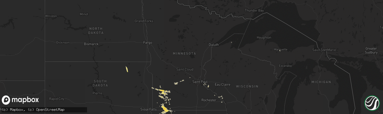
Hail Map in Minnesota on August 18, 2022
The weather event in Minnesota on August 18, 2022 includes Hail and Wind maps. 16 states and 262 cities were impacted and suffered possible damage. The total estimated number of properties impacted is 5,777.
Want more than just the map?
Turn this storm into a full workflow.
- Owner + property data so you know who to knock
- OnDemand branded weather history reports to win the "did we even have hail?" argument
- RoofTrace estimate so reps stop guessing numbers at the door
Bought this map? Upgrade within 7 days and we'll credit the $230. (10-15 min setup call)
Hail
Wind
5,777
Estimated number of impacted properties by a 1.00" hail or larger157
Estimated number of impacted properties by a 1.75" hail or larger0
Estimated number of impacted properties by a 2.50" hail or largerStorm reports in Minnesota
Minnesota
| Date | Description |
|---|---|
| 08/18/20226:45 PM CDT | A local report indicates 1.00 inch wind near 8 NW OCHEYEDAN |
| 08/18/20226:23 PM CDT | A local report indicates 1.75 inch wind near 5 SSW WORTHINGTON |
| 08/18/20226:17 PM CDT | Large tree down blocking road. Winds estimated 60 mph. |
| 08/18/20226:12 PM CDT | . |
| 08/18/20223:34 PM CDT | Picture via social media. Time estimated via radar. |
| 08/18/20223:19 PM CDT | A local report indicates 1.50 inch wind near 2 NE MARSHALL |
| 08/18/20223:19 PM CDT | Several 3 to 4 inch branches down. 5 acres of beans damaged. |
| 08/18/20223:18 PM CDT | A local report indicates 1.00 inch wind near 2 NNW MARSHALL |
| 08/18/202212:15 AM CDT | At 514 PM CDT, a cluster of severe thunderstorms was located over Storden, or 12 miles northwest of Windom, moving east at 40 mph. HAZARD...60 mph wind gusts and half dollar size hail. SOURCE...Radar indicated. IMPACT...Hail damage to vehicles is expected. Expect wind damage to roofs, siding, and trees. These severe thunderstorms will be near... Jeffers around 520 PM CDT. Windom around 530 PM CDT. Bingham Lake around 535 PM CDT. Mountain Lake around 545 PM CDT.Other locations impacted by this severe thunderstorm include Kinbrae,Wilder, Dundee, Delft, Okabena and Avoca. |
| 08/17/202211:22 PM CDT | At 421 PM CDT, a severe thunderstorm was located near Balaton, or 14 miles north of Slayton, moving southeast at 25 mph. HAZARD...60 mph wind gusts and half dollar size hail. SOURCE...Radar indicated. IMPACT...Hail damage to vehicles is expected. Expect wind damage to roofs, siding, and trees. This severe thunderstorm will be near... Tracy and Lake Shetek State Park around 445 PM CDT. Currie around 455 PM CDT. Westbrook and Dovray around 500 PM CDT.Other locations impacted by this severe thunderstorm include Garvin. |
| 08/17/202210:16 PM CDT | At 315 PM CDT, a severe thunderstorm was located 8 miles east of Marshall, slowly moving east at 20 mph. HAZARD...60 mph wind gusts and quarter size hail. SOURCE...Radar indicated. IMPACT...Hail damage to vehicles is expected. Expect wind damage to roofs, siding, and trees. This severe thunderstorm will remain over mainly rural areas of west central Redwood County, including the following locations... Seaforth, Vesta, Lucan and Milroy. |
| 08/17/202210:09 PM CDT | At 309 PM CDT, a severe thunderstorm was located near Marshall, moving east at 20 mph. HAZARD...60 mph wind gusts and half dollar size hail. SOURCE...Radar indicated. IMPACT...Hail damage to vehicles is expected. Expect wind damage to roofs, siding, and trees. This severe thunderstorm will remain over mainly rural areas of northeastern Lyon County. |
| 08/17/20229:50 PM CDT | At 250 PM CDT, two severe thunderstorms were located near Taunton, or 18 miles northwest of Marshall, moving east at 20 mph. HAZARD...60 mph wind gusts and half dollar size hail. SOURCE...Radar indicated. IMPACT...Hail damage to vehicles is expected. Expect wind damage to roofs, siding, and trees. These severe thunderstorms will be near... Taunton around 300 PM CDT. Minneota around 310 PM CDT. Ghent around 325 PM CDT. |
All States Impacted by Hail Map on August 18, 2022
Cities Impacted by Hail Map on August 18, 2022
- Bayfield, WI
- Spencer, IA
- Dickens, IA
- Sibley, IA
- Ashton, IA
- Sheldon, IA
- Sanborn, IA
- Cooperstown, ND
- Hannaford, ND
- Kellogg, MN
- Caldwell, TX
- Rock Valley, IA
- Duson, LA
- Scott, LA
- Rayne, LA
- Walnut Grove, MN
- Beaumont, TX
- Currie, MN
- Revere, MN
- Hawthorne, FL
- Geneva, FL
- Oviedo, FL
- Vidor, TX
- Orange, TX
- Gibbon, NE
- Rockville, NE
- Loup City, NE
- Shelton, NE
- Ravenna, NE
- Rockdale, TX
- Cokato, MN
- Dassel, MN
- Lampasas, TX
- Columbia, SD
- Groton, SD
- Bath, SD
- Wayne, NE
- Bancroft, NE
- Pender, NE
- Wakefield, NE
- Hull, TX
- Palm City, FL
- Lake Placid, FL
- Upland, NE
- Minden, NE
- Kearney, NE
- Pleasanton, NE
- Estherville, IA
- Galesville, WI
- Trempealeau, WI
- Dodge, WI
- George, IA
- Fellsmere, FL
- Palm Bay, FL
- El Campo, TX
- Balaton, MN
- Liberty, TX
- Marcus, IA
- Hartley, IA
- Battle Creek, IA
- Ida Grove, IA
- Schleswig, IA
- Danbury, IA
- Stanton, NE
- Norfolk, NE
- Cleghorn, IA
- Anthon, IA
- Redwood Falls, MN
- Wabasso, MN
- Ghent, MN
- Milroy, MN
- Ivanhoe, MN
- Marshall, MN
- Minneota, MN
- Tracy, MN
- Lucan, MN
- Porter, MN
- Taunton, MN
- Vesta, MN
- Mapleton, IA
- Jeffers, MN
- Tonopah, AZ
- Cherokee, IA
- Buckeye, AZ
- Pekin, ND
- Edgerton, MN
- Harris, IA
- Worthington, MN
- Melvin, IA
- Ocheyedan, IA
- Bigelow, MN
- Reading, MN
- Lake Park, IA
- Brewster, MN
- Lakefield, MN
- Round Lake, MN
- Wilmont, MN
- Rushmore, MN
- Fulda, MN
- Soldier, IA
- Ute, IA
- Charter Oak, IA
- Denison, IA
- Castana, IA
- Dow City, IA
- Woolwine, VA
- Gorham, KS
- Westbrook, MN
- Avoca, MN
- Milford, IA
- Ashton, NE
- White Oak, GA
- Greenville, IA
- Sioux Rapids, IA
- Royal, IA
- Linn Grove, IA
- Peterson, IA
- Le Mars, IA
- Maurice, IA
- Primghar, IA
- Sutherland, IA
- Jackson, MN
- Lexington, TX
- Elgin, TX
- Berlin, ND
- Dickey, ND
- Heron Lake, MN
- Windom, MN
- Hutchinson, MN
- Russell, MN
- Lynd, MN
- Spirit Lake, IA
- Eunice, LA
- Reddick, FL
- Williston, FL
- Lamberton, MN
- Virginia City, NV
- Christmas, FL
- Houghton, SD
- Sugar Land, TX
- Richmond, TX
- River Falls, WI
- Prescott, WI
- Hastings, MN
- Fountain City, WI
- Remsen, IA
- Glen Saint Mary, FL
- Kiron, IA
- Deloit, IA
- Spring, TX
- Hinton, IA
- Merrill, IA
- Seligman, AZ
- Iola, TX
- Bryan, TX
- Clarkfield, MN
- Cottonwood, MN
- Palm Beach Gardens, FL
- Loxahatchee, FL
- West Palm Beach, FL
- Binford, ND
- Mcville, ND
- Paullina, IA
- Larrabee, IA
- Brandt, SD
- Hendricks, MN
- Astoria, SD
- Canby, MN
- Hager City, WI
- Ellsworth, WI
- Beldenville, WI
- Alpine, TX
- Moscow, TX
- Livingston, TX
- Slayton, MN
- Garvin, MN
- Kirkland, AZ
- Kirbyville, TX
- Jasper, TX
- Kingwood, TX
- Warren, TX
- Genoa, NE
- Saint Edward, NE
- Quimby, IA
- Kenedy, TX
- Washta, IA
- Storden, MN
- Pearland, TX
- Lindsay, NE
- Stromsburg, NE
- Newman Grove, NE
- Osceola, NE
- Clarks, NE
- Silver Creek, NE
- Arthur, IA
- Odebolt, IA
- Tekamah, NE
- Rosalie, NE
- Decatur, NE
- Craig, NE
- Lyons, NE
- Long Island, KS
- Prairie View, KS
- Almena, KS
- Sioux Center, IA
- Hawarden, IA
- Pierson, IA
- Crowley, LA
- Mondamin, IA
- Okoboji, IA
- Houston, TX
- Ireton, IA
- Hudson, SD
- Kingsley, IA
- Cushing, IA
- Correctionville, IA
- Dakota, MN
- Holstein, IA
- Bird Island, MN
- Hector, MN
- Beaver City, NE
- Basile, LA
- Oyens, IA
- Akron, IA
- Brunsville, IA
- Galva, IA
- Aurelia, IA
- Manvel, TX
- Rosharon, TX
- Cuero, TX
- Chiefland, FL
- Blythe, CA
- Moville, IA
- Stamford, NE
- Marquette, MI
- Gwinn, MI
- Kingman, AZ
- Oakland, NE
- Boelus, NE
- Goliad, TX
- Missouri City, TX
- Edna, TX
- Citra, FL
- Yoakum, TX
- Cosmos, MN
- Buffalo Lake, MN
- Olivia, MN
- Wellton, AZ
- Arcadia, WI
- Thorndale, TX
- Winona, MN
- Houston, MN
- Sour Lake, TX
- Buffalo, MN
- Adrian, MN
- Jacksonville, FL
- Devers, TX
- Silsbee, TX
- Fred, TX
- Spurger, TX
- Wood River, NE
- Walthill, NE


