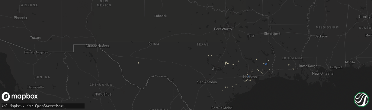
Hail Map in Texas on August 18, 2022
The weather event in Texas on August 18, 2022 includes Hail and Wind maps. 16 states and 262 cities were impacted and suffered possible damage. The total estimated number of properties impacted is 4,031.
Want more than just the map?
Turn this storm into a full workflow.
- Owner + property data so you know who to knock
- OnDemand branded weather history reports to win the "did we even have hail?" argument
- RoofTrace estimate so reps stop guessing numbers at the door
Bought this map? Upgrade within 7 days and we'll credit the $230. (10-15 min setup call)
Hail
Wind
4,031
Estimated number of impacted properties by a 1.00" hail or larger0
Estimated number of impacted properties by a 1.75" hail or larger0
Estimated number of impacted properties by a 2.50" hail or largerStorm reports in Texas
Texas
| Date | Description |
|---|---|
| 08/18/20225:29 PM CDT | Estimated 60mph gusts in video provided by county official near i-610 and i-10w. |
| 08/18/202212:21 AM CDT | At 520 PM CDT, a severe thunderstorm was located over The Galleria, or over Greenway / Upper Kirby Area, moving southeast at 25 mph. HAZARD...60 mph wind gusts. SOURCE...Radar indicated. IMPACT...Expect damage to roofs, siding, and trees. Locations impacted include... Pearland, eastern Missouri City, northern Friendswood, Stafford, South Houston, Bellaire, West University Place, northern Manvel, Hunters Creek Village, Bunker Hill Village, Piney Point Village, Downtown Houston, Greenway / Upper Kirby Area, Spring Branch North, Second Ward, Greater Heights, Fresno, South Belt / Ellington, Neartown / Montrose and Memorial Park. |
| 08/18/202212:02 AM CDT | At 502 PM CDT, a severe thunderstorm was located over Greater Greenspoint, moving southeast at 25 mph. HAZARD...60 mph wind gusts. SOURCE...Radar indicated. IMPACT...Expect damage to roofs, siding, and trees. Locations impacted include... Greater Greenspoint, Aldine, northern Northside / Northline, Hidden Valley, Acres Home, Greater Inwood and Eastex / Jensen Area. |
| 08/17/202211:46 PM CDT | At 446 PM CDT, a severe thunderstorm was located over northeastern Pearland, moving north at 10 mph. HAZARD...60 mph wind gusts and quarter size hail. SOURCE...Radar indicated. IMPACT...Hail damage to vehicles is expected. Expect wind damage to roofs, siding, and trees. Locations impacted include... Western Pasadena, Pearland, Friendswood, South Houston, northern Manvel, Greater Hobby Area, South Belt / Ellington, western Clear Lake, Brookside Village, Golfcrest / Bellfort / Reveille, Edgebrook Area, South Park, Minnetex, South Acres / Crestmont Park, Sunnyside, Hobby Airport, Ellington Field and Meadowbrook / Allendale. |
| 08/17/202211:27 PM CDT | At 427 PM CDT, a severe thunderstorm was located over Caney Head, or near Fred, moving southeast at 25 mph. HAZARD...60 mph wind gusts. SOURCE...Radar indicated. IMPACT...Expect damage to roofs, siding, and trees. Locations impacted include... Buna, Evadale, Fred and Caney Head. |
| 08/17/20229:22 PM CDT | At 222 PM CDT, a severe thunderstorm was located near Daisetta, or 9 miles northeast of Liberty, moving southeast at 10 mph. HAZARD...60 mph wind gusts and penny size hail. SOURCE...Radar indicated. IMPACT...Expect damage to roofs, siding, and trees. Locations impacted include... Northeastern Liberty, Ames, Daisetta, Hardin and Devers. |
All States Impacted by Hail Map on August 18, 2022
Cities Impacted by Hail Map on August 18, 2022
- Bayfield, WI
- Spencer, IA
- Dickens, IA
- Sibley, IA
- Ashton, IA
- Sheldon, IA
- Sanborn, IA
- Cooperstown, ND
- Hannaford, ND
- Kellogg, MN
- Caldwell, TX
- Rock Valley, IA
- Duson, LA
- Scott, LA
- Rayne, LA
- Walnut Grove, MN
- Beaumont, TX
- Currie, MN
- Revere, MN
- Hawthorne, FL
- Geneva, FL
- Oviedo, FL
- Vidor, TX
- Orange, TX
- Gibbon, NE
- Rockville, NE
- Loup City, NE
- Shelton, NE
- Ravenna, NE
- Rockdale, TX
- Cokato, MN
- Dassel, MN
- Lampasas, TX
- Columbia, SD
- Groton, SD
- Bath, SD
- Wayne, NE
- Bancroft, NE
- Pender, NE
- Wakefield, NE
- Hull, TX
- Palm City, FL
- Lake Placid, FL
- Upland, NE
- Minden, NE
- Kearney, NE
- Pleasanton, NE
- Estherville, IA
- Galesville, WI
- Trempealeau, WI
- Dodge, WI
- George, IA
- Fellsmere, FL
- Palm Bay, FL
- El Campo, TX
- Balaton, MN
- Liberty, TX
- Marcus, IA
- Hartley, IA
- Battle Creek, IA
- Ida Grove, IA
- Schleswig, IA
- Danbury, IA
- Stanton, NE
- Norfolk, NE
- Cleghorn, IA
- Anthon, IA
- Redwood Falls, MN
- Wabasso, MN
- Ghent, MN
- Milroy, MN
- Ivanhoe, MN
- Marshall, MN
- Minneota, MN
- Tracy, MN
- Lucan, MN
- Porter, MN
- Taunton, MN
- Vesta, MN
- Mapleton, IA
- Jeffers, MN
- Tonopah, AZ
- Cherokee, IA
- Buckeye, AZ
- Pekin, ND
- Edgerton, MN
- Harris, IA
- Worthington, MN
- Melvin, IA
- Ocheyedan, IA
- Bigelow, MN
- Reading, MN
- Lake Park, IA
- Brewster, MN
- Lakefield, MN
- Round Lake, MN
- Wilmont, MN
- Rushmore, MN
- Fulda, MN
- Soldier, IA
- Ute, IA
- Charter Oak, IA
- Denison, IA
- Castana, IA
- Dow City, IA
- Woolwine, VA
- Gorham, KS
- Westbrook, MN
- Avoca, MN
- Milford, IA
- Ashton, NE
- White Oak, GA
- Greenville, IA
- Sioux Rapids, IA
- Royal, IA
- Linn Grove, IA
- Peterson, IA
- Le Mars, IA
- Maurice, IA
- Primghar, IA
- Sutherland, IA
- Jackson, MN
- Lexington, TX
- Elgin, TX
- Berlin, ND
- Dickey, ND
- Heron Lake, MN
- Windom, MN
- Hutchinson, MN
- Russell, MN
- Lynd, MN
- Spirit Lake, IA
- Eunice, LA
- Reddick, FL
- Williston, FL
- Lamberton, MN
- Virginia City, NV
- Christmas, FL
- Houghton, SD
- Sugar Land, TX
- Richmond, TX
- River Falls, WI
- Prescott, WI
- Hastings, MN
- Fountain City, WI
- Remsen, IA
- Glen Saint Mary, FL
- Kiron, IA
- Deloit, IA
- Spring, TX
- Hinton, IA
- Merrill, IA
- Seligman, AZ
- Iola, TX
- Bryan, TX
- Clarkfield, MN
- Cottonwood, MN
- Palm Beach Gardens, FL
- Loxahatchee, FL
- West Palm Beach, FL
- Binford, ND
- Mcville, ND
- Paullina, IA
- Larrabee, IA
- Brandt, SD
- Hendricks, MN
- Astoria, SD
- Canby, MN
- Hager City, WI
- Ellsworth, WI
- Beldenville, WI
- Alpine, TX
- Moscow, TX
- Livingston, TX
- Slayton, MN
- Garvin, MN
- Kirkland, AZ
- Kirbyville, TX
- Jasper, TX
- Kingwood, TX
- Warren, TX
- Genoa, NE
- Saint Edward, NE
- Quimby, IA
- Kenedy, TX
- Washta, IA
- Storden, MN
- Pearland, TX
- Lindsay, NE
- Stromsburg, NE
- Newman Grove, NE
- Osceola, NE
- Clarks, NE
- Silver Creek, NE
- Arthur, IA
- Odebolt, IA
- Tekamah, NE
- Rosalie, NE
- Decatur, NE
- Craig, NE
- Lyons, NE
- Long Island, KS
- Prairie View, KS
- Almena, KS
- Sioux Center, IA
- Hawarden, IA
- Pierson, IA
- Crowley, LA
- Mondamin, IA
- Okoboji, IA
- Houston, TX
- Ireton, IA
- Hudson, SD
- Kingsley, IA
- Cushing, IA
- Correctionville, IA
- Dakota, MN
- Holstein, IA
- Bird Island, MN
- Hector, MN
- Beaver City, NE
- Basile, LA
- Oyens, IA
- Akron, IA
- Brunsville, IA
- Galva, IA
- Aurelia, IA
- Manvel, TX
- Rosharon, TX
- Cuero, TX
- Chiefland, FL
- Blythe, CA
- Moville, IA
- Stamford, NE
- Marquette, MI
- Gwinn, MI
- Kingman, AZ
- Oakland, NE
- Boelus, NE
- Goliad, TX
- Missouri City, TX
- Edna, TX
- Citra, FL
- Yoakum, TX
- Cosmos, MN
- Buffalo Lake, MN
- Olivia, MN
- Wellton, AZ
- Arcadia, WI
- Thorndale, TX
- Winona, MN
- Houston, MN
- Sour Lake, TX
- Buffalo, MN
- Adrian, MN
- Jacksonville, FL
- Devers, TX
- Silsbee, TX
- Fred, TX
- Spurger, TX
- Wood River, NE
- Walthill, NE


