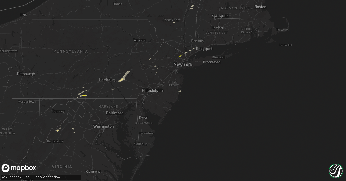
Hail Map in New Jersey on August 17, 2018
Get this storm
August 17 map
$229
one time, instant access
Download today. No call, no setup
Keep the $229
Bought the map and want the full workflow? Apply the entire $229 to a subscription within 7 days. None of it is wasted.
Every map, not just this one
This buys you this map. Subscription and you get every map we run, in the markets you choose from a few cities to whole states to nationwide. Plus real-time alerts the moment a storm fires.
Contact data
Name, contact info, occupancy, even credit band for addresses in the footprint. You go from where it hit to who to call.
Become the source they trust
Unlimited branding weather history reports on demand. You already have the documented answer ready for the property owner, and you are the one who showed up with it.
Property data and RoofTrace estimates
Pull up any address you have got, its value and the exact code rules for that jurisdiction, straight from One Click Code. Then RoofTrace estimates the squares, pitch, and roof value, priced the way you price.
Storm reports in New Jersey
New Jersey
| Date | Description |
|---|---|
| 08/17/20185:50 PM CDT | A local report indicates 1.00 inch wind near GLEN ROCK |
| 08/17/20185:48 PM CDT | A local report indicates 1.00 inch wind near RIDGEWOOD |
| 08/17/20185:47 PM CDT | A tree and wires down on mt. Pleasant avenue |
| 08/17/20185:34 PM CDT | Reports of a few trees and large branches down in belvidere. Time estimated from radar. |
| 08/17/20185:18 PM CDT | Several reports of tree damage near and northwest of harmony near the delaware river. Time estimated from radar. |
| 08/17/20186:41 AM CDT | At 1141 PM EDT, a severe thunderstorm was located over Millington, or near Plainfield, moving northeast at 35 mph. HAZARD...60 mph wind gusts and penny size hail. SOURCE...Radar indicated. IMPACT...Damage to roofs, siding, trees, and power lines is possible. Locations impacted include... Madison, Middlesex, Florham Park, East Hanover, Bound Brook, Chatham, Far Hills, Millington, Basking Ridge, Society Hill, South Plainfield, North Plainfield, Bernardsville, Dunellen and Watchung. |
| 08/17/20183:05 AM CDT | A local report indicates 66 MPH wind near SEASIDE PARK |
| 08/17/20182:29 AM CDT | At 729 PM EDT, severe thunderstorms were located along a line extending from near Yorktown Heights to Greenwich, moving northeast at 40 mph. HAZARD...60 mph wind gusts and quarter size hail. SOURCE...Radar indicated. IMPACT...Minor hail damage to vehicles is possible. Expect wind damage to trees and power lines. Severe thunderstorms will be near... Norwalk and New Canaan around 745 PM EDT. Westport and Wilton around 755 PM EDT. Ridgefield and Weston around 800 PM EDT. Danbury and Redding around 805 PM EDT. Bethel around 810 PM EDT. |
| 08/17/20182:03 AM CDT | At 702 PM EDT, severe thunderstorms were located along a line extending from Upper Nyack to near Yonkers, moving northeast at 40 mph. HAZARD...60 mph wind gusts and quarter size hail. SOURCE...Radar indicated. IMPACT...Minor hail damage to vehicles is possible. Expect wind damage to trees and power lines. Severe thunderstorms will be near... Ossining and Tarrytown around 705 PM EDT. White Plains around 710 PM EDT. Harrison and Hawthorne around 715 PM EDT. Mount Kisco around 720 PM EDT. Stamford and Greenwich around 730 PM EDT. |
| 08/17/20181:55 AM CDT | A local report indicates 61 MPH wind near SEASIDE HEIGHTS |
| 08/17/201812:59 AM CDT | At 558 PM EDT, a severe thunderstorm was located over Bath, or 9 miles northwest of Easton, moving northeast at 40 mph. HAZARD...60 mph wind gusts and penny size hail. SOURCE...Radar indicated. IMPACT...Damage to roofs, siding, trees, and power lines is possible. Locations impacted include... Bethlehem, Northampton, East Stroudsburg, Nazareth, Bangor, Pen Argyl, Wind Gap, Bath, Belvidere, Oxford, Belfast, Tatamy, East Bangor, Steuben, Stormville, Rossland, Saylorsburg, Roxburg, Beersville and Stroudsburg. |
| 08/16/20188:05 PM CDT | Report of some trees down. Time estimated from radar. |
| 08/16/20187:50 PM CDT | Report of trees down in far hills and bridgewater township. Time estimated from radar. |
| 08/16/20187:35 PM CDT | A local report indicates 65 MPH wind near LEBANON |
| 08/16/20187:23 PM CDT | Trees down onto wires. Wires downed. |
| 08/16/20187:19 PM CDT | Downed tree near intersection of allen road and sunnyview avenue in mansfield twp. Another downed tree at route 57 near watters road. Time estimated from radar. |
| 08/16/20187:19 PM CDT | Several reports of large trees down in washington twp...including on brass castle road and on bartely road. Time estimated from radar. |
| 08/16/20187:17 PM CDT | Tree down near intersection of rt 57 and watters rd. Time estimated from radar. |
| 08/16/20187:07 PM CDT | Downed tree near intersection of rt. 46 and manunka chunk rd. Time estimated from radar. |
All States Impacted by Hail Map on August 17, 2018
Cities Impacted by Hail Map on August 17, 2018
- Woodrow, CO
- Dalhart, TX
- Mountain Park, OK
- Snyder, OK
- Frederick, OK
- Loveland, OK
- Hollister, OK
- Micanopy, FL
- Williston, FL
- Lockney, TX
- Parker, CO
- Newmanstown, PA
- Lebanon, PA
- Cove, AR
- Hatfield, AR
- Stoneham, CO
- Matador, TX
- Lititz, PA
- Manheim, PA
- Stinnett, TX
- Wiggins, CO
- Westcliffe, CO
- Louann, AR
- Smackover, AR
- Bear Lake, MI
- Saddle Brook, NJ
- Paramus, NJ
- Fair Lawn, NJ
- Elmwood Park, NJ
- Nowata, OK
- Vinita, OK
- Foster, OK
- Elmore City, OK
- Gould, OK
- Colorado Springs, CO
- Fountain, CO
- Rogers, NM
- Breaux Bridge, LA
- Chugwater, WY
- Rye, CO
- Colorado City, CO
- Pueblo, CO
- Pearl, MS
- Strasburg, CO
- Roggen, CO
- Bennett, CO
- Wheatland, WY
- Grenville, NM
- Kenton, OK
- Duke, OK
- Fort White, FL
- Branford, FL
- Weldona, CO
- Talala, OK
- Plainview, TX
- Petersburg, TX
- Gainesville, FL
- Rocky Ford, CO
- Nazareth, TX
- Ludowici, GA
- Greencastle, PA
- Texico, NM
- Friona, TX
- Bovina, TX
- Floydada, TX
- Sunray, TX
- Stratford, TX
- Yoder, WY
- Quanah, TX
- Chattanooga, OK
- Orchard, CO
- Kersey, CO
- Crosbyton, TX
- Roaring Springs, TX
- Manitou Springs, CO
- Cascade, CO
- Usaf Academy, CO
- Muleshoe, TX
- Crowell, TX
- Alex, OK
- Blanchard, OK
- Pauls Valley, OK
- Mercersburg, PA
- Chambersburg, PA
- Childress, TX
- Elk City, ID
- McGehee, AR
- Lewisville, AR
- Yoder, CO
- Lake City, FL
- Randlett, OK
- Wichita Falls, TX
- Elizabeth, CO
- Mount Jackson, VA
- Ashuelot, NH
- Winchester, NH
- Headrick, OK
- Morse, TX
- Cache, OK
- Upperstrasburg, PA
- Fort Loudon, PA
- Broken Bow, OK
- Chiefland, FL
- Agate, CO
- La Junta, CO
- Las Animas, CO
- Schaefferstown, PA
- Shartlesville, PA
- Richland, PA
- Stevens, PA
- Mohrsville, PA
- Denver, PA
- Bernville, PA
- Robesonia, PA
- Hamburg, PA
- Myerstown, PA
- Womelsdorf, PA
- La Veta, CO
- Fort Morgan, CO
- Buford, WY
- Granite Canon, WY
- Lodge, SC
- Chickasha, OK
- Amber, OK
- Pocasset, OK
- Dickens, TX
- Borger, TX
- Limon, CO
- Ralls, TX
- Westford, MA
- Acton, MA
- Littleton, MA
- Boxborough, MA
- Boise City, OK
- Arlington, CO
- Haswell, CO
- Eads, CO
- Cheyenne, WY
- Lindon, CO
- Dunnellon, FL
- Ramah, CO
- Thompsonville, MI
- Albin, WY
- Lagrange, WY
- Tulia, TX
- Mena, AR
- High Springs, FL
- Bard, NM
- Huntington, OR
- Lawton, OK
- Saint Thomas, PA
- Valhalla, NY
- Armonk, NY
- Thornwood, NY
- Stratford, OK
- Fargo, GA
- White Springs, FL
- Grahamsville, NY
- Bell, FL
- Frenchtown, NJ
- Stockton, NJ
- Model, CO
- Palatka, FL
- White Post, VA
- Front Royal, VA
- Wynnewood, OK
- Joseph, OR
- Guyton, GA
- Springfield, GA
- Washington, VA
- Throckmorton, TX
- Estill, SC
- Garnett, SC
- Walsenburg, CO
- Littlefield, AZ
- Stonewall, OK
- Tishomingo, OK
- Mccurtain, OK
- Roosevelt, OK
- Hobart, OK
- Goodman, MS
- Sallis, MS
- Tulsa, OK
- Indiahoma, OK
- Edinburg, VA
- Mill River, MA
- Great Barrington, MA
- Camden, AR
- Mathias, WV
- Paoli, OK
- Florissant, CO
- Palisades, NY
- Tarrytown, NY
- Northvale, NJ
- Piermont, NY
- Sparkill, NY
- Kiowa, CO
- Brooklet, GA
- Kaleva, MI
- Lost City, WV
- Eldorado, OK
- Olney, TX
- Fayette, MS
- Roxie, MS
- Byers, TX
- Paducah, TX
- Imnaha, OR
- Canon City, CO
- New Raymer, CO
- Flomot, TX
- Saint Augustine, FL
- Monument, CO
- Middleburg, FL
- Green Cove Springs, FL
- Shamrock, TX
- Roff, OK
- Brandon, MS
- Northampton, PA
- York, PA
- Timberville, VA
- Quicksburg, VA
- Hilliard, FL
- Folkston, GA
- Jemez Springs, NM
- Bentonville, VA
- Boone, CO
- Lafayette, LA
- Copemish, MI
- Arkadelphia, AR
- Sparkman, AR
- Charles Town, WV
- Shenandoah Junction, WV
- Kearneysville, WV
- Woodland Park, CO
- Ocean Gate, NJ
- Seaside Park, NJ
- Bayville, NJ
- Faxon, OK
- Walters, OK
- Keota, OK
- Asbury, NJ
- Bloomsbury, NJ
- Stigler, OK
- Effingham, SC
- Eupora, MS
- Peyton, CO
- Spiro, OK
- Bedford, NY
- Marion, NC
- Reevesville, SC
- Saint George, SC
- Altus, OK
- Tipton, OK
- Hudson, NY
- Ghent, NY
- Hollandale, MS
- Pittstown, NJ
- Florence, SC
- Palmer Lake, CO
- Deming, NM
- Ellisville, MS
- Wind Gap, PA
- Pen Argyl, PA
- Mosquero, NM
- Cameron, OK
- Pocola, OK
- Big Cove Tannery, PA
- Keenesburg, CO
- Divide, CO
- Pampa, TX
- Twin Falls, ID
- Castle Rock, CO
- Bowman, SC
- Canton, MS
- Jacksonville, FL
- Blackshear, GA
- Waycross, GA
- Vernon, VT
- Hinsdale, NH
- Swanzey, NH
- Dermott, AR
- Shady Point, OK
- Valatie, NY
- Kinderhook, NY
- Chatham, NY
- Stamford, CT
- Pound Ridge, NY
- Pineland, SC
- Islandton, SC
- Williams, SC
- Ruffin, SC
- Smoaks, SC
- Bokoshe, OK
- Glen Rock, NJ
- Township Of Washington, NJ
- Emerson, NJ
- Westwood, NJ
- Ridgewood, NJ
- Paterson, NJ


