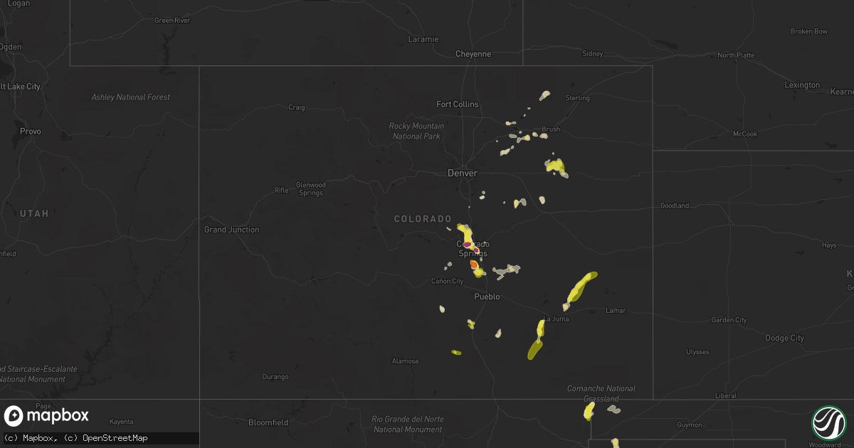
Hail Map in Colorado on August 17, 2018
Get this storm
August 17 map
$229
one time, instant access
Download today. No call, no setup
Keep the $229
Bought the map and want the full workflow? Apply the entire $229 to a subscription within 7 days. None of it is wasted.
Every map, not just this one
This buys you this map. Subscription and you get every map we run, in the markets you choose from a few cities to whole states to nationwide. Plus real-time alerts the moment a storm fires.
Contact data
Name, contact info, occupancy, even credit band for addresses in the footprint. You go from where it hit to who to call.
Become the source they trust
Unlimited branding weather history reports on demand. You already have the documented answer ready for the property owner, and you are the one who showed up with it.
Property data and RoofTrace estimates
Pull up any address you have got, its value and the exact code rules for that jurisdiction, straight from One Click Code. Then RoofTrace estimates the squares, pitch, and roof value, priced the way you price.
Storm reports in Colorado
Colorado
| Date | Description |
|---|---|
| 08/17/20186:49 PM CDT | A local report indicates 1.00 inch wind near 6 WNW WOODLIN SCHOOL |
| 08/17/20186:42 PM CDT | Mesonet station co046... 4 wnw woodlin school. |
| 08/17/20184:57 PM CDT | A local report indicates 60 MPH wind near 3 W FOUNTAIN |
| 08/17/20184:50 PM CDT | A local report indicates 1.75 inch wind near 3 SE COLORADO SPRINGS |
| 08/17/20184:24 PM CDT | A local report indicates 1.50 inch wind near 3 ENE MANITOU SPRINGS |
| 08/17/20184:23 PM CDT | A local report indicates 1.50 inch wind near 5 NE MANITOU SPRINGS |
| 08/17/20184:22 PM CDT | A local report indicates 1.00 inch wind near 2 WSW COLORADO SPRINGS |
| 08/17/20184:22 PM CDT | A local report indicates 1.00 inch wind near 1 WNW COLORADO SPRINGS |
| 08/17/20184:21 PM CDT | Reported at memorial park and briarhurst... Manitou springs. |
| 08/17/20184:19 PM CDT | Reported at memorial park and briarhurst... Manitou springs. |
| 08/17/20184:18 PM CDT | A local report indicates 1.00 inch wind near 5 SSE AIR FORCE ACADEMY |
| 08/17/20184:10 PM CDT | Mostly quarter to half dollar sized hail with a few up to 1.5 inch. |
| 08/17/20183:51 PM CDT | A local report indicates 1.00 inch wind near 3 SSW MONUMENT |
| 08/17/20182:05 AM CDT | At 704 PM MDT, a severe thunderstorm was located near Haswell, or 37 miles northwest of Lamar, moving northeast at 35 mph. HAZARD...60 mph wind gusts and half dollar size hail. SOURCE...Radar indicated. IMPACT...Hail damage to vehicles is expected. Expect wind damage to roofs, siding, and trees. Locations impacted include... Areas east and northeast of Haswell. |
| 08/17/20181:24 AM CDT | At 624 PM MDT, a severe thunderstorm was located near Blue Lake, or 22 miles northeast of North La Junta, moving northeast at 20 mph. HAZARD...60 mph wind gusts and half dollar size hail. SOURCE...Radar indicated. IMPACT...Hail damage to vehicles is expected. Expect wind damage to roofs, siding, and trees. Locations impacted include... Haswell, Blue Lake and Arlington. |
| 08/17/201812:45 AM CDT | At 545 PM MDT, a severe thunderstorm was located over Woodlin School, or 30 miles southwest of Akron, moving east at 15 mph. HAZARD...60 mph wind gusts and quarter size hail. SOURCE...Radar indicated. IMPACT...Expect damage to roofs, siding, and trees. Hail damage to vehicles is expected. Locations impacted include... Woodlin School, Last Chance and Lindon. |
| 08/16/201811:34 PM CDT | At 434 PM MDT, a severe thunderstorm was located near Victor, or 23 miles southwest of Colorado Springs, moving southeast at 5 mph. HAZARD...60 mph wind gusts and quarter size hail. SOURCE...Radar indicated. IMPACT...Hail damage to vehicles is expected. Expect wind damage to roofs, siding, and trees. Locations impacted include... Cripple Creek and Victor areas. |
| 08/16/201811:27 PM CDT | At 427 PM MDT, a severe thunderstorm was located near Fountain, or 16 miles south of Colorado Springs, moving south at 10 mph. HAZARD...Golf ball size hail and 60 mph wind gusts. SOURCE...Radar indicated. IMPACT...People and animals outdoors will be injured. Expect hail damage to roofs, siding, windows, and vehicles. Expect wind damage to roofs, siding, and trees. Locations impacted include... Fountain and Security-Widefield. |
| 08/16/201811:26 PM CDT | At 425 PM MDT, a severe thunderstorm was located near Timpas, or 14 miles southwest of La Junta, moving north at 30 mph. HAZARD...60 mph wind gusts and quarter size hail. SOURCE...Radar indicated. IMPACT...Hail damage to vehicles is expected. Expect wind damage to roofs, siding, and trees. Locations impacted include... Rocky Ford, Ordway, Swink, Manzanola, Crowley and Timpas. |
| 08/16/201811:02 PM CDT | At 401 PM MDT, a severe thunderstorm was located near Fountain, or 13 miles south of Colorado Springs, moving south at 5 mph. HAZARD...Golf ball size hail and 60 mph wind gusts. SOURCE...Radar indicated. IMPACT...People and animals outdoors will be injured. Expect hail damage to roofs, siding, windows, and vehicles. Expect wind damage to roofs, siding, and trees. Locations impacted include... Fountain and Security-Widefield. |
| 08/16/201810:40 PM CDT | At 340 PM MDT, a severe thunderstorm was located over southern Colorado Springs, moving southeast at 10 mph. HAZARD...Quarter size hail. SOURCE...Radar indicated. IMPACT...Damage to vehicles is expected. Locations impacted include... Colorado Springs, Fountain, Stratmoor, Fort Carson, Security, Peterson AFB, Security-Widefield and Cimarron Hills. |
| 08/16/201810:32 PM CDT | At 332 PM MDT, a severe thunderstorm was located 8 miles southwest of Kenton, or 24 miles north of Clayton, moving north at 15 mph. HAZARD...60 mph wind gusts and quarter size hail. SOURCE...Radar indicated. IMPACT...Hail damage to vehicles is expected. Expect wind damage to roofs, siding, and trees. This severe thunderstorm will remain over mainly rural areas of northeastern Union County. |
| 08/16/201810:10 PM CDT | At 310 PM MDT, a severe thunderstorm was located over western Colorado Springs, moving southeast at 10 mph. HAZARD...Quarter size hail. SOURCE...Radar indicated. IMPACT...Damage to vehicles is expected. Locations impacted include... Colorado Springs, Air Force Academy, Manitou Springs, Stratmoor, Fort Carson, Security, Peterson AFB, Cimarron Hills, Cascade, Chipita Park and Security-Widefield. |
| 08/16/20189:56 PM CDT | At 256 PM MDT, a severe thunderstorm was located 11 miles northeast of Greenhorn Mountain, or 24 miles southwest of Pueblo, moving east at 10 mph. HAZARD...Quarter size hail. SOURCE...Radar indicated. IMPACT...Damage to vehicles is expected. Locations impacted include... Colorado City. |
| 08/16/20189:38 PM CDT | At 238 PM MDT, a severe thunderstorm was located near Palmer Lake, or 18 miles northwest of Colorado Springs, moving southeast at 20 mph. HAZARD...Half dollar size hail. SOURCE...Radar indicated. IMPACT...Damage to vehicles is expected. Locations impacted include... Colorado Springs, Woodland Park, Monument, Air Force Academy, Palmer Lake, Black Forest and Gleneagle. |
| 08/16/20188:04 PM CDT | A local report indicates 1.00 inch wind near 3 ENE HASWELL |
All States Impacted by Hail Map on August 17, 2018
Cities Impacted by Hail Map on August 17, 2018
- Woodrow, CO
- Dalhart, TX
- Mountain Park, OK
- Snyder, OK
- Frederick, OK
- Loveland, OK
- Hollister, OK
- Micanopy, FL
- Williston, FL
- Lockney, TX
- Parker, CO
- Newmanstown, PA
- Lebanon, PA
- Cove, AR
- Hatfield, AR
- Stoneham, CO
- Matador, TX
- Lititz, PA
- Manheim, PA
- Stinnett, TX
- Wiggins, CO
- Westcliffe, CO
- Louann, AR
- Smackover, AR
- Bear Lake, MI
- Saddle Brook, NJ
- Paramus, NJ
- Fair Lawn, NJ
- Elmwood Park, NJ
- Nowata, OK
- Vinita, OK
- Foster, OK
- Elmore City, OK
- Gould, OK
- Colorado Springs, CO
- Fountain, CO
- Rogers, NM
- Breaux Bridge, LA
- Chugwater, WY
- Rye, CO
- Colorado City, CO
- Pueblo, CO
- Pearl, MS
- Strasburg, CO
- Roggen, CO
- Bennett, CO
- Wheatland, WY
- Grenville, NM
- Kenton, OK
- Duke, OK
- Fort White, FL
- Branford, FL
- Weldona, CO
- Talala, OK
- Plainview, TX
- Petersburg, TX
- Gainesville, FL
- Rocky Ford, CO
- Nazareth, TX
- Ludowici, GA
- Greencastle, PA
- Texico, NM
- Friona, TX
- Bovina, TX
- Floydada, TX
- Sunray, TX
- Stratford, TX
- Yoder, WY
- Quanah, TX
- Chattanooga, OK
- Orchard, CO
- Kersey, CO
- Crosbyton, TX
- Roaring Springs, TX
- Manitou Springs, CO
- Cascade, CO
- Usaf Academy, CO
- Muleshoe, TX
- Crowell, TX
- Alex, OK
- Blanchard, OK
- Pauls Valley, OK
- Mercersburg, PA
- Chambersburg, PA
- Childress, TX
- Elk City, ID
- McGehee, AR
- Lewisville, AR
- Yoder, CO
- Lake City, FL
- Randlett, OK
- Wichita Falls, TX
- Elizabeth, CO
- Mount Jackson, VA
- Ashuelot, NH
- Winchester, NH
- Headrick, OK
- Morse, TX
- Cache, OK
- Upperstrasburg, PA
- Fort Loudon, PA
- Broken Bow, OK
- Chiefland, FL
- Agate, CO
- La Junta, CO
- Las Animas, CO
- Schaefferstown, PA
- Shartlesville, PA
- Richland, PA
- Stevens, PA
- Mohrsville, PA
- Denver, PA
- Bernville, PA
- Robesonia, PA
- Hamburg, PA
- Myerstown, PA
- Womelsdorf, PA
- La Veta, CO
- Fort Morgan, CO
- Buford, WY
- Granite Canon, WY
- Lodge, SC
- Chickasha, OK
- Amber, OK
- Pocasset, OK
- Dickens, TX
- Borger, TX
- Limon, CO
- Ralls, TX
- Westford, MA
- Acton, MA
- Littleton, MA
- Boxborough, MA
- Boise City, OK
- Arlington, CO
- Haswell, CO
- Eads, CO
- Cheyenne, WY
- Lindon, CO
- Dunnellon, FL
- Ramah, CO
- Thompsonville, MI
- Albin, WY
- Lagrange, WY
- Tulia, TX
- Mena, AR
- High Springs, FL
- Bard, NM
- Huntington, OR
- Lawton, OK
- Saint Thomas, PA
- Valhalla, NY
- Armonk, NY
- Thornwood, NY
- Stratford, OK
- Fargo, GA
- White Springs, FL
- Grahamsville, NY
- Bell, FL
- Frenchtown, NJ
- Stockton, NJ
- Model, CO
- Palatka, FL
- White Post, VA
- Front Royal, VA
- Wynnewood, OK
- Joseph, OR
- Guyton, GA
- Springfield, GA
- Washington, VA
- Throckmorton, TX
- Estill, SC
- Garnett, SC
- Walsenburg, CO
- Littlefield, AZ
- Stonewall, OK
- Tishomingo, OK
- Mccurtain, OK
- Roosevelt, OK
- Hobart, OK
- Goodman, MS
- Sallis, MS
- Tulsa, OK
- Indiahoma, OK
- Edinburg, VA
- Mill River, MA
- Great Barrington, MA
- Camden, AR
- Mathias, WV
- Paoli, OK
- Florissant, CO
- Palisades, NY
- Tarrytown, NY
- Northvale, NJ
- Piermont, NY
- Sparkill, NY
- Kiowa, CO
- Brooklet, GA
- Kaleva, MI
- Lost City, WV
- Eldorado, OK
- Olney, TX
- Fayette, MS
- Roxie, MS
- Byers, TX
- Paducah, TX
- Imnaha, OR
- Canon City, CO
- New Raymer, CO
- Flomot, TX
- Saint Augustine, FL
- Monument, CO
- Middleburg, FL
- Green Cove Springs, FL
- Shamrock, TX
- Roff, OK
- Brandon, MS
- Northampton, PA
- York, PA
- Timberville, VA
- Quicksburg, VA
- Hilliard, FL
- Folkston, GA
- Jemez Springs, NM
- Bentonville, VA
- Boone, CO
- Lafayette, LA
- Copemish, MI
- Arkadelphia, AR
- Sparkman, AR
- Charles Town, WV
- Shenandoah Junction, WV
- Kearneysville, WV
- Woodland Park, CO
- Ocean Gate, NJ
- Seaside Park, NJ
- Bayville, NJ
- Faxon, OK
- Walters, OK
- Keota, OK
- Asbury, NJ
- Bloomsbury, NJ
- Stigler, OK
- Effingham, SC
- Eupora, MS
- Peyton, CO
- Spiro, OK
- Bedford, NY
- Marion, NC
- Reevesville, SC
- Saint George, SC
- Altus, OK
- Tipton, OK
- Hudson, NY
- Ghent, NY
- Hollandale, MS
- Pittstown, NJ
- Florence, SC
- Palmer Lake, CO
- Deming, NM
- Ellisville, MS
- Wind Gap, PA
- Pen Argyl, PA
- Mosquero, NM
- Cameron, OK
- Pocola, OK
- Big Cove Tannery, PA
- Keenesburg, CO
- Divide, CO
- Pampa, TX
- Twin Falls, ID
- Castle Rock, CO
- Bowman, SC
- Canton, MS
- Jacksonville, FL
- Blackshear, GA
- Waycross, GA
- Vernon, VT
- Hinsdale, NH
- Swanzey, NH
- Dermott, AR
- Shady Point, OK
- Valatie, NY
- Kinderhook, NY
- Chatham, NY
- Stamford, CT
- Pound Ridge, NY
- Pineland, SC
- Islandton, SC
- Williams, SC
- Ruffin, SC
- Smoaks, SC
- Bokoshe, OK
- Glen Rock, NJ
- Township Of Washington, NJ
- Emerson, NJ
- Westwood, NJ
- Ridgewood, NJ
- Paterson, NJ


