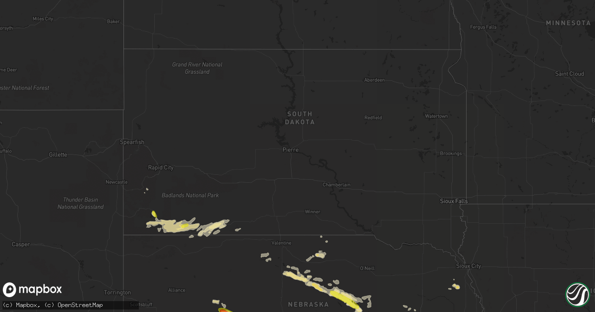
Hail Map in South Dakota on August 15, 2018
Get this storm
August 15 map
$229
one time, instant access
Download today. No call, no setup
Keep the $229
Bought the map and want the full workflow? Apply the entire $229 to a subscription within 7 days. None of it is wasted.
Every map, not just this one
This buys you this map. Subscription and you get every map we run, in the markets you choose from a few cities to whole states to nationwide. Plus real-time alerts the moment a storm fires.
Contact data
Name, contact info, occupancy, even credit band for addresses in the footprint. You go from where it hit to who to call.
Become the source they trust
Unlimited branding weather history reports on demand. You already have the documented answer ready for the property owner, and you are the one who showed up with it.
Property data and RoofTrace estimates
Pull up any address you have got, its value and the exact code rules for that jurisdiction, straight from One Click Code. Then RoofTrace estimates the squares, pitch, and roof value, priced the way you price.
Storm reports in South Dakota
South Dakota
| Date | Description |
|---|---|
| 08/15/20184:45 PM CDT | Delayed report. Time estimated from radar. |
| 08/15/20184:28 PM CDT | A local report indicates 60 MPH wind near 3 NE ANGOSTURA RESERVOI |
| 08/15/20188:55 AM CDT | Time estimated from radar and spotters location on her way to work |
| 08/15/20182:25 AM CDT | At 725 AM MDT, a severe thunderstorm was located near Swett, or 8 miles west of Martin, moving east at 40 mph. HAZARD...Quarter size hail. SOURCE...Radar indicated. IMPACT...Damage to vehicles is expected. Locations impacted include... Martin, Allen, Tuthill, Harrington, Swett, Vetal and northeastern Lacreek Wildlife Refuge. |
| 08/15/20181:54 AM CDT | At 654 AM MDT, a severe thunderstorm was located 10 miles southeast of Oelrichs, or 25 miles west of Pine Ridge, moving east at 45 mph. HAZARD...Half dollar size hail. SOURCE...Radar indicated. IMPACT...Damage to vehicles is expected. Locations impacted include... Pine Ridge, Oglala, Porcupine, Manderson, Wounded Knee and Slim Buttes. |
| 08/14/201810:27 PM CDT | At 327 PM MDT, a severe thunderstorm was located near Angostura Reservoir, or 7 miles southeast of Hot Springs, moving south at 15 mph. HAZARD...Half dollar size hail. SOURCE...Radar indicated. IMPACT...Damage to vehicles is expected. Locations impacted include... Oelrichs, Smithwick, Hay Canyon Butte and Angostura Reservoir. |
All States Impacted by Hail Map on August 15, 2018
Cities Impacted by Hail Map on August 15, 2018
- Bartlett, NE
- Ericson, NE
- Chambers, NE
- Sundance, WY
- Mountain Center, CA
- Ainsworth, NE
- Johnstown, NE
- Lake Clear, NY
- Saranac Lake, NY
- Thurston, NE
- Pender, NE
- Hereford, TX
- Tulia, TX
- Kress, TX
- Plainview, TX
- Clayton, NY
- Scotia, NE
- Ord, NE
- Silverton, TX
- Burwell, NE
- Saint Paul, NE
- Farwell, NE
- Dannebrog, NE
- Happy, TX
- Baton Rouge, LA
- Arthur, NE
- Wagon Mound, NM
- Houlton, ME
- Sutherland, NE
- Saint Libory, NE
- Grand Island, NE
- Theresa, NY
- La Fargeville, NY
- Alexandria Bay, NY
- Bristol, VT
- New Haven, VT
- Middlebury, VT
- Okabena, MN
- Lakefield, MN
- North Platte, NE
- Tell City, IN
- Weston, CO
- Friona, TX
- Summerfield, TX
- Loup City, NE
- Wood Lake, NE
- Greeley, NE
- Taylor, NE
- Hayes Center, NE
- Osseo, WI
- Martin, SD
- Allen, SD
- Batesland, SD
- Elsmere, NE
- Eagle Lake, ME
- Conchas Dam, NM
- Trementina, NM
- Eustis, NE
- Maxwell, NE
- Hershey, NE
- Farnam, NE
- Moorefield, NE
- Brady, NE
- Paxton, NE
- Kevil, KY
- Grand Chain, IL
- La Center, KY
- High Springs, FL
- Limestone, ME
- Des Moines, NM
- Brule, NE
- Ogallala, NE
- Big Springs, NE
- Spearman, TX
- Peyton, CO
- Calhan, CO
- Hot Springs, SD
- Bassett, NE
- Long Pine, NE
- Ashby, NE
- Hyannis, NE
- Pine Valley, CA
- Karval, CO
- Colorado Springs, CO
- Reed, KY
- Bucksport, ME
- Wayside, TX
- Comstock, NE
- Sargent, NE
- Broken Bow, NE
- Orland, ME
- Harned, KY
- Hawesville, KY
- Cannelton, IN
- Dimmitt, TX
- Dickens, NE
- Wallace, NE
- Custer, SD
- Mills, NE
- Falls Of Rough, KY
- Adrian, MN
- Oelrichs, SD
- Elba, NE
- Ashton, NE
- Nara Visa, NM
- Campo, CA
- Boulevard, CA
- Edgemont, SD
- Bingham, NE
- Saint Gabriel, LA
- Grand Isle, ME
- Pine Ridge, SD
- Smithwick, SD
- Ashland, ME
- Oxford, AL
- Texhoma, OK
- Goodwell, OK
- Reynolds Station, KY
- Cloverport, KY
- Sikeston, MO
- Bushnell, FL
- Gothenburg, NE
- Lincolnville, ME
- Islesboro, ME
- Emerson, NE
- Cozad, NE
- Humphrey, NE
- Leigh, NE
- Creston, NE
- Platte Center, NE
- Columbus, NE
- Lindsay, NE
- Broadview, NM
- Nebo, KY
- Broseley, MO
- Ambrose, GA
- Wray, GA
- Broxton, GA
- Springview, NE
- Fairchild, WI
- Wilmington, NY
- Hardinsburg, KY
- Surry, ME
- Ellsworth, ME
- Trenton, FL
- Kim, CO
- Madison, NE
- Van Buren, ME
- Hammond, NY
- Redwood, NY
- Thedford, NE
- Las Animas, CO
- Oral, SD
- Whitesville, KY
- Fordsville, KY
- Canadian, TX
- Wounded Knee, SD
- Oglala, SD
- Manderson, SD
- Edgerton, MN
- Amelia, NE
- Gouverneur, NY
- Newman Grove, NE
- Palmer, NE
- Boelus, NE
- North Loup, NE
- Perryton, TX
- Cape Vincent, NY
- Arcadia, NE
- Fredonia, KY
- Marion, KY
- Brooksville, FL
- Chapman, NE
- Winterport, ME
- Rushville, NE
- Newberry, FL
- Bloomingdale, NY
- Westview, KY
- Metropolis, IL
- Belknap, IL
- Punta Gorda, FL
- Cairo, NE
- Childress, TX
- Qulin, MO
- Tuthill, SD
- Danville, AR
- Valentine, NE
- Palomar Mountain, CA
- Willsboro, NY
- Edgewood, NM
- Parker, AZ
- Morrill, ME
- Grenville, NM
- Newport, NE
- Dexter, NY
- Chaumont, NY
- Watertown, NY
- Caribou, ME
- Gordon, NE
- Lewisport, KY
- Maceo, KY
- Philpot, KY
- Tryon, NE


