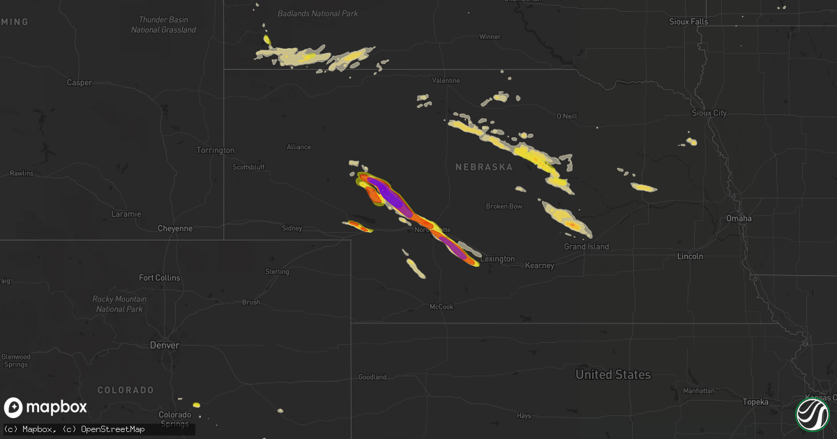
Hail Map on August 15, 2018
Get this storm
August 15 map
$229
one time, instant access
Download today. No call, no setup
Keep the $229
Bought the map and want the full workflow? Apply the entire $229 to a subscription within 7 days. None of it is wasted.
Every map, not just this one
This buys you this map. Subscription and you get every map we run, in the markets you choose from a few cities to whole states to nationwide. Plus real-time alerts the moment a storm fires.
Contact data
Name, contact info, occupancy, even credit band for addresses in the footprint. You go from where it hit to who to call.
Become the source they trust
Unlimited branding weather history reports on demand. You already have the documented answer ready for the property owner, and you are the one who showed up with it.
Property data and RoofTrace estimates
Pull up any address you have got, its value and the exact code rules for that jurisdiction, straight from One Click Code. Then RoofTrace estimates the squares, pitch, and roof value, priced the way you price.
States Impacted by Hail Map on August 15, 2018
Storm reports
Nebraska
| Date | Description |
|---|---|
| 08/15/20186:50 PM CDT | A local report indicates 60 MPH wind near 2 NE HERSHEY |
| 08/15/20186:11 PM CDT | Ping pong to golf ball hail at largest. Wind gusts of 25 mph or less. Time estimated from radar. |
| 08/15/20186:08 PM CDT | A local report indicates 1.00 inch wind near 23 NW SUTHERLAND |
| 08/15/20185:51 PM CDT | Quarter size hail reported at arthur high school. |
| 08/15/20185:35 PM CDT | Quarter size hail and 0.60 inches of rainfall in 30 minutes. |
| 08/15/20185:34 PM CDT | Wide assortment of hail with largest being baseball size. |
| 08/15/20185:22 PM CDT | A local report indicates 1.75 inch wind near 8 N BRULE |
| 08/15/20184:51 PM CDT | Winds maxed at 40mph. Hail accumulated on the property. |
| 08/15/20184:14 AM CDT | Em reported crop damage approximately 2 w of the intersection of highways 281 and 58. Time estimated from radar. |
| 08/15/20184:06 AM CDT | At least 3 pivots knocked over. Time estimated from radar. |
| 08/15/20184:03 AM CDT | Delayed report via social media of golf ball size hail. Report also noted broken windshields...siding....and extensive damage to crops. |
| 08/15/20184:03 AM CDT | Received report from facebook. Time estimated from radar. |
| 08/15/20184:02 AM CDT | Spotter estimates 1000 acres of crops destroyed...corn is now knee-high. An auger was flipped...at least 3 nearby pivots were damaged. Two miles west of this location.. |
| 08/15/20183:58 AM CDT | Spotter estimates winds were at least 70 mph. At their location...large tree branches were downed...a carport was destroyed and a barn door was ripped off. Nearby...piv |
| 08/15/20183:58 AM CDT | Significant amount of hail up to quarter size. Time estimated from radar. |
| 08/15/20183:56 AM CDT | Report received from facebook of damage to a pivot and crop damage from the east edge of farwell to approx 3 miles east of farwell. Time estimated from radar. |
| 08/15/20183:56 AM CDT | Time estimated from radar. |
| 08/15/20183:56 AM CDT | Report received from facebook. Time estimated from radar. |
| 08/15/20182:50 AM CDT | At 750 PM CDT, a severe thunderstorm was located 9 miles southwest of Gothenburg, or 18 miles northeast of Curtis, moving southeast at 35 mph. HAZARD...70 mph wind gusts and half dollar size hail. SOURCE...Radar indicated. IMPACT...Hail damage to vehicles is expected. Expect considerable tree damage. Wind damage is also likely to mobile homes, roofs, and outbuildings. Locations impacted include... Lexington, Cozad, Gothenburg, Willow Island, Johnson Lake and Farnam.This includes Interstate 80 between mile markers 209 and 238. |
| 08/15/20182:45 AM CDT | At 744 PM CDT, a severe thunderstorm was located near Brady, or 21 miles north of Curtis, moving southeast at 35 mph. This is a very dangerous storm. HAZARD...Baseball size hail and 60 mph wind gusts. SOURCE...Radar indicated. IMPACT...People and animals outdoors will be severely injured. Expect shattered windows, extensive damage to roofs, siding, and vehicles. Locations impacted include... Brady, Moorefield, Jeffrey Canyon State Wildlife Management Area, Cottonwood Canyon State Wildlife Management Area and Vroman.This includes Interstate 80 in Nebraska between mile markers 193 and207. |
| 08/15/20182:11 AM CDT | At 711 PM CDT, a severe thunderstorm was located over North Platte Airport, or near North Platte, moving southeast at 35 mph. This is a very dangerous storm. HAZARD...80 mph wind gusts and half dollar size hail. SOURCE...Radar indicated. IMPACT...Flying debris will be dangerous to those caught without shelter. Mobile homes will be heavily damaged. Expect considerable damage to roofs, windows, and vehicles. Extensive tree damage and power outages are likely. Locations impacted include... North Platte, Brady, Maxwell, Lake Maloney State Recreation Area, North Platte Airport, Keith, Cottonwood Canyon State Wildlife Management Area and Jeffrey Canyon State Wildlife Management Area.This includes the following highways... Highway 97 between mile markers 1 and 2. Interstate 80 in Nebraska between mile markers 172 and 202. Highway 83 between mile markers 70 and 94. |
| 08/15/20181:40 AM CDT | At 639 PM CDT, a severe thunderstorm was located near Sutherland, or 17 miles northwest of North Platte, moving southeast at 30 mph. HAZARD...Golf ball size hail. SOURCE...Radar indicated. IMPACT...People and animals outdoors will be injured. Expect damage to roofs, siding, windows, and vehicles. Locations impacted include... North Platte, Sutherland, Hershey, Sutherland Reservoir State Recreation Area, North Platte Airport, Coker, O'Fallons and Birdwood.This includes the following highways... Highway 97 between mile markers 1 and 2. Interstate 80 in Nebraska between mile markers 155 and 181. Highway 83 between mile markers 78 and 87. |
| 08/15/20181:17 AM CDT | At 616 PM CDT/516 PM MDT/, a severe thunderstorm was located 10 miles southeast of Arthur, moving southeast at 30 mph. HAZARD...Quarter size hail. SOURCE...Radar indicated. IMPACT...Damage to vehicles is expected. Locations impacted include... Bucktail Lake.This includes Highway 61 between mile markers 115 and 116. |
| 08/15/20181:01 AM CDT | At 600 PM CDT/500 PM MDT/, a severe thunderstorm was located 18 miles north of Sarben, or 20 miles southeast of Arthur, moving southeast at 35 mph. HAZARD...Tennis ball size hail and 60 mph wind gusts. SOURCE...Radar indicated. IMPACT...People and animals outdoors will be injured. Expect hail damage to roofs, siding, windows, and vehicles. Expect wind damage to roofs, siding, and trees. Locations impacted include... Sutherland, Hershey, Sutherland Reservoir State Recreation Area, Sarben, Big Bald Hill, Coker, O'Fallons and Diamond Bar Lake.This includes the following highways... Highway 92 between mile markers 185 and 187. Interstate 80 in Nebraska between mile markers 149 and 165. |
| 08/15/201812:23 AM CDT | At 522 PM CDT/422 PM MDT/, a severe thunderstorm was located near Arthur, moving southeast at 35 mph. HAZARD...Tennis ball size hail. SOURCE...Radar indicated. IMPACT...People and animals outdoors will be injured. Expect damage to roofs, siding, windows, and vehicles. Locations impacted include... Arthur, Bucktail Lake, Lena, Three Mile Lake, Flatts, Diamond Bar Lake, Bucktail, Calora and Big Bald Hill.This includes the following highways... Highway 61 between mile markers 123 and 128. Highway 92 between mile markers 165 and 185. |
| 08/14/201811:28 PM CDT | At 427 PM MDT, a severe thunderstorm was located 11 miles northwest of Arthur, moving southeast at 30 mph. HAZARD...Two inch hail. SOURCE...Radar indicated. IMPACT...People and animals outdoors will be injured. Expect damage to roofs, siding, windows, and vehicles. Locations impacted include... Arthur, Velma, Haythorn Lake, Jensen Lake and McKeag. This includes the following highways... Highway 61 between mile markers 111 and 130. Highway 92 between mile markers 165 and 167. |
| 08/14/201811:26 PM CDT | At 426 PM MDT, a severe thunderstorm was located near Brule, or near Ogallala, moving east at 25 mph. HAZARD...60 mph wind gusts and half dollar size hail. SOURCE...Radar indicated. IMPACT...Hail damage to vehicles is expected. Expect wind damage to roofs, siding, and trees. Locations impacted include... Ogallala, Paxton, Brule and Roscoe. This includes the following highways... Highway 61 between mile markers 78 and 94. Interstate 80 in Nebraska between mile markers 115 and 147. |
| 08/14/201810:45 PM CDT | At 345 PM MDT, a severe thunderstorm was located 12 miles north of Arthur, moving east at 30 mph. HAZARD...Golf ball size hail. SOURCE...Radar indicated. IMPACT...People and animals outdoors will be injured. Expect damage to roofs, siding, windows, and vehicles. Locations impacted include... Arthur, Jensen Lake, Green Lake, Lena, Sand Puddin Lake, Three Mile Lake and Calora.This includes the following highways... Highway 61 between mile markers 123 and 145. Highway 92 between mile markers 165 and 178. |
| 08/14/20187:39 PM CDT | Accumulating hail with largest being quarter size. Up to 2 inches deep in places. Time estimate from radar. |
| 08/14/20187:36 PM CDT | Hail accumulations covering the ground. Measured 1 inch plus rain in 15 to 20 minutes. Time estimated from radar. |
| 08/14/20187:20 PM CDT | Wind driven hail resulted in crop damage... Corn stalks snapped and leaves shredded. |
| 08/14/20187:11 PM CDT | Reported at the 2800 block of west 6th street. |
| 08/14/20187:09 PM CDT | A local report indicates 1.00 inch wind near NORTH PLATTE |
| 08/14/20187:05 PM CDT | A local report indicates 1.00 inch wind near 1 W NORTH PLATTE |
| 08/14/20187:05 PM CDT | Estimated 70-80 mph wind gusts on west side of north platte. Large tree branch down |
| 08/14/20187:00 PM CDT | Report via social media of golf ball size hail and 0.50 inches of rainfall. |
Indiana
| Date | Description |
|---|---|
| 08/15/20186:55 PM CDT | Tree down at the 6300 block of circle road. |
| 08/15/20186:08 PM CDT | Multiple trees down on the western side of paoli. Also many power outages. |
| 08/15/20186:01 PM CDT | Power line down. |
| 08/15/20185:55 PM CDT | French lick asos. |
| 08/15/20184:55 PM CDT | Numerous trees down. Power lines down also. |
| 08/15/20183:31 AM CDT | At 830 PM EDT, severe thunderstorms were located along a line extending from Jeffersontown to near Elizabethtown, moving east at 40 mph. HAZARD...60 mph wind gusts. SOURCE...A 53 mph wind gust was recroded at Louisville International Airport at 826 pm. IMPACT...Expect damage to roofs, siding, and trees. Locations impacted include... Louisville, Elizabethtown, Jeffersontown, Shepherdsville, Pioneer Village, Hurstbourne Acres, West Buechel, Watterson Park, Lynnview and Hollow Creek. |
| 08/15/20183:07 AM CDT | At 807 PM EDT, severe thunderstorms were located along a line extending from St. Dennis to 11 miles north of Leitchfield, moving east at 40 mph. HAZARD...60 mph wind gusts. SOURCE...Radar indicated. IMPACT...Expect damage to roofs, siding, and trees. Locations impacted include... Louisville, Elizabethtown, Jeffersontown, Shively, Shepherdsville, Pioneer Village, Hurstbourne Acres, Audubon Park, West Buechel and Watterson Park. |
| 08/15/20182:49 AM CDT | At 748 PM EDT/648 PM CDT/, severe thunderstorms were located along a line extending from near Seymour to New Providence Town to 10 miles southeast of Hardinsburg, moving northeast at 45 mph. HAZARD...60 mph wind gusts. SOURCE...Radar indicated. IMPACT...Expect damage to roofs, siding, and trees. Locations impacted include... Louisville, New Albany, Scottsburg, Corydon, Brandenburg, Hardinsburg, New Providence Town, Clarksville, Webster and Vienna. |
| 08/15/20182:17 AM CDT | At 717 PM EDT, a severe thunderstorm was located 8 miles northeast of Paoli, or 14 miles southeast of Bedford, moving northeast at 45 mph. HAZARD...60 mph wind gusts. SOURCE...Radar indicated. IMPACT...Expect damage to roofs, siding, and trees. Locations impacted include... Mitchell, Tunnelton and Spring Mill State Park. |
| 08/15/20182:09 AM CDT | At 709 PM EDT/609 PM CDT/, severe thunderstorms were located along a line extending from 11 miles northeast of Tell City to 11 miles southeast of Whitesville, moving east at 40 mph. HAZARD...70 mph wind gusts. SOURCE...Radar indicated. IMPACT...Expect considerable tree damage. Damage is likely to mobile homes, roofs, and outbuildings. Locations impacted include... Tell City, Corydon, Brandenburg, Hardinsburg, Hawesville, Webster, Cannelton, Irvington, Cloverport and Fordsville. |
| 08/15/201812:29 AM CDT | At 528 PM CDT, severe thunderstorms were located along a line extending from 8 miles east of Winslow to near Jasper to 8 miles northeast of Holiday World, moving northeast at 30 mph. Winds gusted to 43 mph as the storm passed the Huntingburg airport HAZARD...60 mph wind gusts. SOURCE...Radar indicated. IMPACT...Expect damage to roofs, siding, and trees. Locations impacted include... Jasper, Huntingburg, Ferdinand, Birdseye, Dubois, Hillham, Celestine, Millersport, Bretzville and Mentor. |
| 08/14/20187:07 PM CDT | Tree down on highway 11 at morgan lane. |
Maine
| Date | Description |
|---|---|
| 08/15/20184:56 PM CDT | Over a dozen trees snapped or uprooted along a three quarter mile stretch of ogren rd... Some being large trees. Flagpole downed as well. |
| 08/15/20182:46 PM CDT | Corrects previous tstm wnd dmg report from limestone. Trees down. One on east side of route 1a blocked the highway. Two more trees on the west side snapped off. Locatio |
| 08/15/20182:06 PM CDT | Trees down. One on east side of route 1a blocked the highway. Two more trees on the west side snapped off. Location approximately 3.5 miles south of limestone. |
| 08/15/201812:26 AM CDT | A local report indicates 1.00 inch wind near BUCKSPORT |
| 08/15/201812:18 AM CDT | At 518 PM EDT, a severe thunderstorm was located near Madawaska Lake, or 14 miles east of Eagle Lake, moving southeast at 30 mph. HAZARD...60 mph wind gusts and quarter size hail. SOURCE...Radar indicated. IMPACT...Minor hail damage to vehicles is possible. Expect wind damage to trees and power lines. Locations impacted include... Presque Isle, Caribou, Fort Fairfield, Limestone, Mapleton, Washburn, Easton, Woodland, Madawaska Lake, New Sweden, Connor, Perham, Wade, Stockholm and Westmanland. |
| 08/15/201812:15 AM CDT | Hail ranged up to quarter size. The duration of the hail event was 10 minutes. |
| 08/14/201810:44 PM CDT | At 344 PM EDT, a severe thunderstorm was located near 30 15 mph. HAZARD...60 mph wind gusts and quarter size hail. SOURCE...Radar indicated. IMPACT...Minor hail damage to vehicles is possible. Expect wind damage to trees and power lines. Locations impacted include... Presque Isle, Caribou, Fort Fairfield, Mapleton, Washburn, Mars Hill, Easton, Westfield, Chapman, Castle Hill and Wade.Dime size hail has been reported in Mapleton. |
| 08/14/201810:20 PM CDT | At 319 PM EDT, a severe thunderstorm was located near Oxbow, or 26 miles north of Patten, moving southeast at 30 mph. HAZARD...60 mph wind gusts and quarter size hail. SOURCE...Radar indicated. IMPACT...Minor hail damage to vehicles is possible. Expect wind damage to trees and power lines. Locations impacted include... Smyrna, Oxbow, Dudley Township, Smyrna Mills, Oakfield, Merrill, Dyer Brook, Hersey, Dudley, Webbertown, Grand Lake Seboeis, Saint Croix and Moro Plantation.This storm is also producing torrential rain that may result in ponding of water in low lying areas. |
| 08/14/201810:09 PM CDT | At 309 PM EDT, a severe thunderstorm was located 20 miles east of Jackman, moving southeast at 30 mph. HAZARD...60 mph wind gusts and nickel size hail. SOURCE...Radar indicated. IMPACT...Expect damage to roofs, siding, and trees. Locations impacted include... Sapling, Indian Stream, Misery Gore, Misery, Sandwich Academy Grant, Taunton And Raynham Academy Grant, Chase Stream, Rockwood Strip, Squaretown, Long Pond and Parlin Pond. |
Colorado
| Date | Description |
|---|---|
| 08/15/20186:40 PM CDT | From media video. |
| 08/15/201812:22 AM CDT | At 522 PM MDT, a severe thunderstorm was located near Black Forest, or 13 miles northeast of Colorado Springs, moving southeast at 20 mph. HAZARD...60 mph wind gusts and quarter size hail. SOURCE...Radar indicated. IMPACT...Hail damage to vehicles is expected. Expect wind damage to roofs, siding, and trees. Locations impacted include... Northeastern Colorado Springs, Black Forest, Ellicott, Peyton and Falcon. |
| 08/14/20187:24 PM CDT | A local report indicates 1.25 inch wind near 1 S PEYTON |
New Hampshire
| Date | Description |
|---|---|
| 08/15/20183:58 AM CDT | At 858 PM EDT, a severe thunderstorm was located 7 miles east of Bethlehem, moving east at 30 mph. HAZARD...60 mph wind gusts and quarter size hail. SOURCE...Radar indicated. IMPACT...Hail damage to vehicles is expected. Expect wind damage to roofs, siding, and trees. Locations impacted include... Conway, Bethlehem, Lincoln, Franconia, Pinkham Notch, Mount Washington, Carroll, Gorham, Bartlett, Jefferson, Jackson, Chatham, Whitefield, Hart's Location, Randolph, and Livermore.This also includes... Crawford Notch State Park, North Twin Mountain, Mount Jefferson,Mount Madison, and Mount Eisenhower. |
| 08/14/20188:00 PM CDT | Trees and wires down at rt. 3/115 parker rd |
| 08/14/20187:58 PM CDT | Trees down along rt 3. |
South Dakota
| Date | Description |
|---|---|
| 08/15/20184:45 PM CDT | Delayed report. Time estimated from radar. |
| 08/15/20184:28 PM CDT | A local report indicates 60 MPH wind near 3 NE ANGOSTURA RESERVOI |
| 08/15/20188:55 AM CDT | Time estimated from radar and spotters location on her way to work |
| 08/15/20182:25 AM CDT | At 725 AM MDT, a severe thunderstorm was located near Swett, or 8 miles west of Martin, moving east at 40 mph. HAZARD...Quarter size hail. SOURCE...Radar indicated. IMPACT...Damage to vehicles is expected. Locations impacted include... Martin, Allen, Tuthill, Harrington, Swett, Vetal and northeastern Lacreek Wildlife Refuge. |
| 08/15/20181:54 AM CDT | At 654 AM MDT, a severe thunderstorm was located 10 miles southeast of Oelrichs, or 25 miles west of Pine Ridge, moving east at 45 mph. HAZARD...Half dollar size hail. SOURCE...Radar indicated. IMPACT...Damage to vehicles is expected. Locations impacted include... Pine Ridge, Oglala, Porcupine, Manderson, Wounded Knee and Slim Buttes. |
| 08/14/201810:27 PM CDT | At 327 PM MDT, a severe thunderstorm was located near Angostura Reservoir, or 7 miles southeast of Hot Springs, moving south at 15 mph. HAZARD...Half dollar size hail. SOURCE...Radar indicated. IMPACT...Damage to vehicles is expected. Locations impacted include... Oelrichs, Smithwick, Hay Canyon Butte and Angostura Reservoir. |
Florida
| Date | Description |
|---|---|
| 08/14/201810:48 PM CDT | At 348 PM EDT, a severe thunderstorm was located over Unf, moving northeast at 15 mph. HAZARD...60 mph wind gusts. SOURCE...Radar indicated. IMPACT...Expect damage to roofs, siding, and trees. Locations impacted include... Unf, Arlington, Neptune Beach, Baymeadows, San Pablo, Craig Field, Little Talbot Island and Fort Caroline. |
California
| Date | Description |
|---|---|
| 08/14/201810:37 PM CDT | At 337 PM PDT, a severe thunderstorm was located over Palomar Mountain State Park, or 12 miles northeast of Valley Center. This storm is nearly stationary. HAZARD...60 mph wind gusts and nickel size hail. SOURCE...Radar indicated. IMPACT...Expect damage to roofs, siding, and trees. Locations impacted include... Valley Center, Aguanga, Hwy 79 Between Warner Springs And Oak Grove, Palomar Mountain State Park, Palomar Mountain, S7 - East Grade Rd, Hwy 79 Between Oak Grove And Aguanga, La Jolla Indian Reservation, Pauma Valley, Pauma Indian Reservation, Oak Grove and Rincon Indian Reservation. |
| 08/14/201810:30 PM CDT | At 324 PM PDT, a severe thunderstorm was located near Boulevard, or 7 miles northwest of I-8 between Boulevard and Imperial County line moving southeast at about 5 mph. HAZARD...60 mph wind gusts. SOURCE...Radar indicated. IMPACT...Expect damage to roofs, siding, and trees. Locations impacted include... I-8 between Pine Valley and Boulevard, I-8 between Boulevard and Imperial County Line, Campo, Hwy S2 between Canebrake and Imperial County Line, Boulevard, Lake Morena, Tierra Del Sol, Campo Indian Reservation, La Posta Indian Reservation, Live Oak Springs, Jacumba and Manzanita Indian Reservation. |
| 08/14/20189:59 PM CDT | At 258 PM PDT, a severe thunderstorm was located over Hwy 74 Between Mountain Center And Anza and nearly stationary. HAZARD...60 mph wind gusts and quarter size hail. SOURCE...Radar indicated. IMPACT...Hail damage to vehicles is expected. Expect wind damage to roofs, siding, and trees. Locations impacted include... Idyllwild-Pine Cove, Anza, Hwy 243 Between Banning And Idyllwild, Mt San Jacinto State Park, Hwy 74 Between Hemet And Mountain Center, Hwy 74 Between Mountain Center And Anza, Mountain Center, Lake Hemet, Cahuilla Indian Reservation and Santa Rosa Mountain. |
| 08/14/20189:09 PM CDT | At 208 PM PDT, a severe thunderstorm was located near Hwy 79 Between Warner Springs And Oak Grove, or 12 miles south of Anza. This storm was nearly stationary. HAZARD...60 mph wind gusts and penny size hail. SOURCE...Radar indicated. IMPACT...Expect damage to roofs, siding, and trees. Locations impacted include... Southeastern Anza, Warner Springs, Hwy 79 Between Warner Springs And Oak Grove, Lake Henshaw, Hwy 74 Between Anza And Palm Desert, S7 - East Grade Rd, Hwy 79 Between Oak Grove And Aguanga, Borrego Palm Canyon, Hwy 79 Between Santa Ysabel And Warner Springs, Aguanga, Hwy S2 Between Hwy 79 And Hwy 78, Cahuilla Indian Reservation, Oak Grove, Los Coyotes Indian Reservation and Santa Rosa Mountain. |
| 08/14/20188:59 PM CDT | At 157 PM PDT, a severe thunderstorm was located near Hwy 78 Between S2 And Borrego Springs Rd, and nearly stationary. HAZARD...60 mph wind gusts. SOURCE...Radar indicated. IMPACT...Expect damage to roofs, siding, and trees. Locations impacted include... Alpine, Hwy 78 Between Banner And S2, I-8 Between Pine Valley And Boulevard, Mount Laguna, Cuyamaca Rancho State Park, Julian, Hwy 78 Between S2 And Borrego Springs Rd, Hwy S2 Between Shelter Valley And Agua Caliente, Ranchita, Lake Morena, Lake Cuyamaca, Pine Valley, Hwy S1 Between Lake Cuyamaca And Mount Laguna, Hwy 79 Between Julian And Lake Cuyamaca, Descanso, Hwy S2 Between Hwy 79 And Hwy 78, Hwy 78 Between Ramona And Santa Ysabel, San Diego Country Estates, Potrero and Hwy S22 Between Ranchita And Borrego Springs. |
| 08/14/20187:40 PM CDT | Delayed report. Time is estimated from radar. Spotter reported 8 power lines down. 3 mobile trailers were flipped over with one being completely destroyed. |
| 08/14/20187:18 PM CDT | *** 1 inj *** california highway patrol reported two overturned semis and one milage sign blown over due to thunderstorm related winds. Time estimated from radar. |
| 08/14/20187:11 PM CDT | Chp reports two semis overturned. 1 minor injury. Large mileage sign blown down. |
Alabama
| Date | Description |
|---|---|
| 08/14/20187:04 PM CDT | Couple of trees and power poles down. |
New York
| Date | Description |
|---|---|
| 08/15/20184:06 PM CDT | Estimated just smaller than a golf ball... Cars dented. Time estimated from radar. |
| 08/15/20181:57 AM CDT | At 656 PM EDT, a severe thunderstorm was located near Cranberry Lake, moving east at 35 mph. HAZARD...60 mph wind gusts and quarter size hail. SOURCE...Radar indicated. IMPACT...Minor hail damage to vehicles is possible. Expect wind damage to trees and powerlines. Locations impacted include... Tupper Lake, Piercefield, Carry Falls Reservoir, Wawbeek, Cranberry Lake, Conifer, Saranac Inn, St. Regis Mountain, Gale, Childwold, Shurtleff, Axton Landing and Coreys. |
| 08/14/201811:52 PM CDT | At 451 PM EDT, a severe thunderstorm was located near Lewey Lake Campground, or 7 miles northwest of Speculator, moving southeast at 15 mph. HAZARD...60 mph wind gusts and quarter size hail. SOURCE...Radar indicated. IMPACT...Hail damage to vehicles is expected. Expect wind damage to roofs, siding, and trees. This severe thunderstorm will be near... Lewey Lake Campground around 510 PM EDT. Speculator around 535 PM EDT.Other locations impacted by this severe thunderstorm include SledHarbor, Bakers Mills, Sabael, Perkins Clearing, West Canada Lakes,Edwards Hill and Christian Hill. |
| 08/14/201811:48 PM CDT | At 447 PM EDT, a severe thunderstorm was located near Clayton, or 25 miles northwest of Fort Drum, moving east at 25 mph. HAZARD...Golf ball size hail and 60 mph wind gusts. SOURCE...Radar indicated. IMPACT...People and animals outdoors will be injured. Expect hail damage to roofs, siding, windows, and vehicles. Expect wind damage to roofs, siding, and trees. Locations impacted include... Kring Point State Park, Wellesley Island State Park, Redwood, Alexandria Bay, Theresa, Plessis, Oxbow and Muskellunge Lake.This includes Interstate 81 between exits 50 and 52. |
| 08/14/201811:29 PM CDT | At 429 PM EDT, a severe thunderstorm was located 10 miles west of Cedar Point State Park, or 29 miles northwest of Watertown, moving southeast at 20 mph. HAZARD...60 mph wind gusts and quarter size hail. SOURCE...Radar indicated. IMPACT...Minor damage to vehicles is possible. Expect wind damage to roofs, siding, and trees. Locations impacted include... Stony Point, Clayton, Dexter, Glen Park, Henderson Harbor, Cedar Point State Park, Sackets Harbor and Henderson.This includes Interstate 81 between exits 48 and 49. |
| 08/14/20187:03 PM CDT | A few downed trees were reported along old military rd. And deerwood trails. |
Oklahoma
| Date | Description |
|---|---|
| 08/15/20187:00 AM CDT | At 1200 AM CDT, severe thunderstorms were located along a line extending from 3 miles north of Roosevelt to near Warren to 3 miles northwest of Mangum, moving southeast at 25 mph. HAZARD...Ping pong ball size hail and 60 mph wind gusts. SOURCE...Radar indicated. IMPACT...People and animals outdoors will be injured. Expect hail damage to roofs, siding, windows, and vehicles. Expect wind damage to roofs, siding, and trees. Locations impacted include... Altus, Mangum, Snyder, Blair, Olustee, Mountain Park, Roosevelt, Manitou, Martha, Headrick, Friendship, Cooperton, Altus Air Force Base, Tom Steed Reservoir, Warren, Humphreys, Hester and Altus-Lugert Lake. |
| 08/15/20185:35 AM CDT | Photo of hail stone relayed via social media. |
| 08/15/20185:00 AM CDT | Large tree limb on vehicle near broken arrow expressway and south 145th ave. Via video. |
Illinois
| Date | Description |
|---|---|
| 08/15/20182:23 PM CDT | More than 10 trees down some of which brought power lines down and caused power outages in mounds. |
| 08/15/20182:18 PM CDT | Large trees down just northwest of cairo along route 3. |
Kentucky
| Date | Description |
|---|---|
| 08/15/20186:57 PM CDT | Power pole down along highway 477. |
| 08/15/20186:45 PM CDT | Trees down along highway 261 and over much of the western part of the county. |
| 08/15/20186:35 PM CDT | Metal roof blown off barn... Shed completely blown apart... Several chicken coops completely flattened... Multiple trees in a row blown over all in same direction. |
| 08/15/20186:28 PM CDT | Trees down. Dryer lifted and landed on car. |
| 08/15/20185:31 PM CDT | Trees and power lines down. |
| 08/15/20185:26 PM CDT | Trees down. |
| 08/15/20186:30 AM CDT | At 1130 PM CDT, a severe thunderstorm was located 12 miles northeast of Hartford, moving northeast at 40 mph. HAZARD...60 mph wind gusts. SOURCE...Automated Observing Station. At 1125 PM CDT...the Ohio County Kentucky Mesonet station reported a 60 mph wind gust. IMPACT...Expect damage to roofs, siding, and trees. Locations impacted include... Hardinsburg, Fordsville, Concord, Horse Branch, Mcquady, Se Ree, Shreve, Westview, Tousey and Magan. |
| 08/15/20183:12 AM CDT | At 811 PM EDT/711 PM CDT/, a severe thunderstorm was located 9 miles north of Leitchfield, moving east at 30 mph. HAZARD...60 mph wind gusts. SOURCE...Radar indicated. IMPACT...Expect damage to roofs, siding, and trees. Locations impacted include... Leitchfield, Mcdaniels, Indian Valley, Constantine, Limp, Saint Paul, Hudson, Cobblers Knob, Solway and Tar Hill. |
| 08/15/20182:22 AM CDT | At 721 PM EDT, severe thunderstorms were located along a line extending from near Bedford to 10 miles west of Salem to 9 miles east of English to 6 miles south of Carefree Town, moving northeast at 35 mph. HAZARD...60 mph wind gusts. SOURCE...Radar indicated. IMPACT...Expect damage to roofs, siding, and trees. Locations impacted include... Salem, Carefree Town, Palmyra, Milltown, Campbellsburg, Hardinsburg, Leavenworth, Livonia, Saltillo and Fredericksburg. |
| 08/15/20182:05 AM CDT | At 703 PM EDT/603 PM CDT/, severe thunderstorms were located along a line extending from near Shoals to near Paoli to 6 miles southwest of English to near Tell City, moving northeast at 30 mph. Winds gusted to 67 mph at French Lick as the storm went through. HAZARD...70 mph wind gusts. SOURCE...Radar indicated. IMPACT...Expect considerable tree damage. Damage is likely to mobile homes, roofs, and outbuildings. Locations impacted include... Tell City, Paoli, English, Carefree Town, Mount Pleasant, Orleans, French Lick, Stampers Creek, Marengo and Milltown. |
| 08/14/201811:47 PM CDT | At 447 PM CDT, severe thunderstorms were located along a line extending from near Lynnville to Stanley, moving east at 35 mph. HAZARD...60 mph wind gusts and penny size hail. SOURCE...Radar indicated. IMPACT...Expect damage to roofs, siding, and trees. Locations impacted include... Evansville, Owensboro, Boonville, Newburgh, Chandler, Rockport, Dale, Lynnville, Grandview, Knottsville, Folsomville, Stanley, Holiday World, Eureka, Elberfeld, Chrisney, Tennyson and Gentryville. |
| 08/14/201811:25 PM CDT | Measured at ohio county mesonet station. |
| 08/14/201810:02 PM CDT | At 302 PM CDT, a severe thunderstorm was located near Rosiclare, or 17 miles northwest of Marion, moving northeast at 35 mph. HAZARD...60 mph wind gusts and penny size hail. SOURCE...Radar indicated. IMPACT...Expect damage to roofs, siding, and trees. Locations impacted include... Rosiclare, Cave-in-Rock, Elizabethtown, Carrsville and Gross. |
| 08/14/20189:14 PM CDT | At 213 PM CDT, a severe thunderstorm was located near Charleston, moving northeast at 50 mph. HAZARD...60 mph wind gusts. SOURCE...Radar indicated. IMPACT...Expect damage to roofs, siding, and trees. Locations impacted include... Charleston, Cairo, Wickliffe, Mounds, Mound City, Horseshoe Lake Conservation Area, Diehlstadt and Wilson City. |
| 08/14/20187:27 PM CDT | Trees down in the 1600 block of loney lane. |
Texas
| Date | Description |
|---|---|
| 08/15/20186:10 PM CDT | A local report indicates 69 MPH wind near 2 ENE TULIA |
| 08/15/20187:38 AM CDT | At 1238 AM CDT, severe thunderstorms were located along a line extending from 4 miles northeast of Headrick to 3 miles west of Tipton to near Olustee, moving southeast at 20 mph. HAZARD...60 mph wind gusts and quarter size hail. SOURCE...Radar indicated. IMPACT...Hail damage to vehicles is expected. Expect wind damage to roofs, siding, and trees. Locations impacted include... Altus, Frederick, Snyder, Tipton, Olustee, Manitou, Elmer, Headrick, Friendship, Altus Air Force Base, Humphreys and Hess. |
| 08/15/20183:44 AM CDT | At 844 PM CDT, a severe thunderstorm was located over Summerfield, or 10 miles southwest of Hereford, moving northwest at 10 mph. HAZARD...70 mph wind gusts and quarter size hail. SOURCE...Radar indicated. IMPACT...Hail damage to vehicles is expected. Expect considerable tree damage. Wind damage is also likely to mobile homes, roofs, and outbuildings. Locations impacted include... Summerfield and Black. |
| 08/15/20183:31 AM CDT | At 830 PM CDT, a severe thunderstorm was located 4 miles northeast of Rhea, or 10 miles northwest of Friona, moving northwest at 15 mph. HAZARD...70 mph wind gusts and quarter size hail. SOURCE...Radar indicated. IMPACT...Hail damage to vehicles is expected. Expect considerable tree damage. Wind damage is also likely to mobile homes, roofs, and outbuildings. Locations impacted include... Friona and Rhea. |
| 08/15/20182:07 AM CDT | At 706 PM CDT, a severe thunderstorm was located 4 miles southeast of Kress, or 8 miles north of Plainview, moving south at 15 mph. HAZARD...70 mph wind gusts and quarter size hail. SOURCE...Radar indicated. IMPACT...Hail damage to vehicles is expected. Expect considerable tree damage. Wind damage is also likely to mobile homes, roofs, and outbuildings. Locations impacted include... Plainview and Seth Ward. |
| 08/15/20181:32 AM CDT | At 632 PM CDT, a severe thunderstorm was located 7 miles northeast of Kress, or 7 miles southeast of Tulia, moving south at 15 mph. HAZARD...70 mph wind gusts and quarter size hail. SOURCE...Radar indicated. IMPACT...Hail damage to vehicles is expected. Expect considerable tree damage. Wind damage is also likely to mobile homes, roofs, and outbuildings. Locations impacted include... Kress and Claytonville. |
| 08/15/20181:08 AM CDT | At 607 PM CDT, a severe thunderstorm was located 4 miles east of Tulia, moving southeast at 20 mph. HAZARD...60 mph wind gusts and quarter size hail. SOURCE...Radar indicated. IMPACT...Hail damage to vehicles is expected. Expect wind damage to roofs, siding, and trees. This severe thunderstorm will remain over mainly rural areas of east central Swisher County. |
| 08/15/201812:32 AM CDT | At 532 PM CDT, a severe thunderstorm was located 6 miles northeast of Happy, or 14 miles southeast of Canyon, moving northeast at 5 mph. HAZARD...60 mph wind gusts and half dollar size hail. SOURCE...Radar indicated. IMPACT...Minor damage to roofs, siding, and trees is possible. Hail damage to vehicles is expected. Locations impacted include... Wayside and Palo Duro Canyon. |
| 08/14/201810:00 PM CDT | A local report indicates 74 MPH wind near 2 NE FRIONA |
| 08/14/20188:45 PM CDT | A local report indicates 1.25 inch wind near SUMMERFIELD |
Nevada
| Date | Description |
|---|---|
| 08/15/20184:39 PM CDT | Combs canyon raws. |
Michigan
| Date | Description |
|---|---|
| 08/15/201812:13 AM CDT | At 513 PM EDT, a severe thunderstorm was located near Mio, moving east at 15 mph. HAZARD...60 mph wind gusts and quarter size hail. SOURCE...Radar indicated. IMPACT...Hail damage to vehicles is expected. Expect wind damage to roofs, siding, and trees. Locations impacted include... Mio, Fairview and Red Oak. |
Mississippi
| Date | Description |
|---|---|
| 08/14/201811:53 PM CDT | At 453 PM CDT, a severe thunderstorm was located near Edwards, or 13 miles west of Clinton, and is nearly stationary. HAZARD...60 mph wind gusts and half dollar size hail. SOURCE...Radar indicated. IMPACT...Hail damage to vehicles is expected. Expect wind damage to roofs, siding, and trees. Locations impacted include... Edwards, Bolton and Learned. |
Louisiana
| Date | Description |
|---|---|
| 08/15/20181:06 AM CDT | At 606 PM CDT, a severe thunderstorm was located over Village St. George, or near Oak Hills Place, and is nearly stationary. HAZARD...60 mph wind gusts and nickel size hail. SOURCE...Radar indicated. IMPACT...Expect damage to roofs, siding, and trees. Locations impacted include... Baton Rouge, Denham Springs, Oak Hills Place, Westminster, Old Jefferson, Village St. George, Inniswold, Shenandoah and Gardere. |
New Mexico
| Date | Description |
|---|---|
| 08/14/201811:42 PM CDT | At 441 PM MDT, a severe thunderstorm was located 12 miles east of Wagon Mound, moving east at 25 mph. HAZARD...60 mph wind gusts and quarter size hail. SOURCE...Radar indicated. IMPACT...Hail damage to vehicles is expected. Expect wind damage to roofs, siding, and trees. Locations impacted include... Chicosa Lake State Park. |
| 08/14/201811:30 PM CDT | At 430 PM MDT, a severe thunderstorm was located near Grenville, or 12 miles southeast of Des Moines, moving southeast at 10 mph. HAZARD...60 mph wind gusts and quarter size hail. SOURCE...Radar indicated. IMPACT...Hail damage to vehicles is expected. Expect wind damage to roofs, siding, and trees. Locations impacted include... Grenville. |
| 08/14/201810:32 PM CDT | At 332 PM MDT, a severe thunderstorm was located 19 miles north of Clayton Lake State Park, or 24 miles east of Des Moines, moving southeast at 10 mph. HAZARD...60 mph wind gusts and quarter size hail. SOURCE...Radar indicated. IMPACT...Hail damage to vehicles is expected. Expect wind damage to roofs, siding, and trees. This severe thunderstorm will remain over mainly rural areas of northeastern Union County. |
| 08/14/20188:52 PM CDT | At 151 PM MDT, a severe thunderstorm was located near Cokedale, or 9 miles southwest of Trinidad, moving east at 15 mph. HAZARD...60 mph wind gusts and half dollar size hail. SOURCE...Radar indicated. IMPACT...Hail damage to vehicles is expected. Expect wind damage to roofs, siding, and trees. Locations impacted include... Trinidad, Aguilar, Cokedale, Starkville, Gulnare, Boncarbo, Segundo and Raton Pass. |
Vermont
| Date | Description |
|---|---|
| 08/15/20182:56 AM CDT | At 756 PM EDT, severe thunderstorms were located along a line extending from near Bloomingdale to near North Elba, moving east at 30 mph. HAZARD...60 mph wind gusts and quarter size hail. SOURCE...Radar indicated. IMPACT...Minor hail damage to vehicles is possible. Expect wind damage to trees and powerlines. Locations impacted include... Lake Placid, Saranac Lake, Westport, Wilmington, Elizabethtown, Keene, Au Sable Forks, Jay In Essex County, Keene Valley, North Elba, Lewis, Upper Jay, Young Bay, Ray Brook, North West Bay, Clintonville, Mount Van Hoevenberg, Deerhead, New Russia and South Bay In Essex County. |
Cities Impacted by Hail Map on August 15, 2018
- Bartlett, NE
- Ericson, NE
- Chambers, NE
- Sundance, WY
- Mountain Center, CA
- Ainsworth, NE
- Johnstown, NE
- Lake Clear, NY
- Saranac Lake, NY
- Thurston, NE
- Pender, NE
- Hereford, TX
- Tulia, TX
- Kress, TX
- Plainview, TX
- Clayton, NY
- Scotia, NE
- Ord, NE
- Silverton, TX
- Burwell, NE
- Saint Paul, NE
- Farwell, NE
- Dannebrog, NE
- Happy, TX
- Baton Rouge, LA
- Arthur, NE
- Wagon Mound, NM
- Houlton, ME
- Sutherland, NE
- Saint Libory, NE
- Grand Island, NE
- Theresa, NY
- La Fargeville, NY
- Alexandria Bay, NY
- Bristol, VT
- New Haven, VT
- Middlebury, VT
- Okabena, MN
- Lakefield, MN
- North Platte, NE
- Tell City, IN
- Weston, CO
- Friona, TX
- Summerfield, TX
- Loup City, NE
- Wood Lake, NE
- Greeley, NE
- Taylor, NE
- Hayes Center, NE
- Osseo, WI
- Martin, SD
- Allen, SD
- Batesland, SD
- Elsmere, NE
- Eagle Lake, ME
- Conchas Dam, NM
- Trementina, NM
- Eustis, NE
- Maxwell, NE
- Hershey, NE
- Farnam, NE
- Moorefield, NE
- Brady, NE
- Paxton, NE
- Kevil, KY
- Grand Chain, IL
- La Center, KY
- High Springs, FL
- Limestone, ME
- Des Moines, NM
- Brule, NE
- Ogallala, NE
- Big Springs, NE
- Spearman, TX
- Peyton, CO
- Calhan, CO
- Hot Springs, SD
- Bassett, NE
- Long Pine, NE
- Ashby, NE
- Hyannis, NE
- Pine Valley, CA
- Karval, CO
- Colorado Springs, CO
- Reed, KY
- Bucksport, ME
- Wayside, TX
- Comstock, NE
- Sargent, NE
- Broken Bow, NE
- Orland, ME
- Harned, KY
- Hawesville, KY
- Cannelton, IN
- Dimmitt, TX
- Dickens, NE
- Wallace, NE
- Custer, SD
- Mills, NE
- Falls Of Rough, KY
- Adrian, MN
- Oelrichs, SD
- Elba, NE
- Ashton, NE
- Nara Visa, NM
- Campo, CA
- Boulevard, CA
- Edgemont, SD
- Bingham, NE
- Saint Gabriel, LA
- Grand Isle, ME
- Pine Ridge, SD
- Smithwick, SD
- Ashland, ME
- Oxford, AL
- Texhoma, OK
- Goodwell, OK
- Reynolds Station, KY
- Cloverport, KY
- Sikeston, MO
- Bushnell, FL
- Gothenburg, NE
- Lincolnville, ME
- Islesboro, ME
- Emerson, NE
- Cozad, NE
- Humphrey, NE
- Leigh, NE
- Creston, NE
- Platte Center, NE
- Columbus, NE
- Lindsay, NE
- Broadview, NM
- Nebo, KY
- Broseley, MO
- Ambrose, GA
- Wray, GA
- Broxton, GA
- Springview, NE
- Fairchild, WI
- Wilmington, NY
- Hardinsburg, KY
- Surry, ME
- Ellsworth, ME
- Trenton, FL
- Kim, CO
- Madison, NE
- Van Buren, ME
- Hammond, NY
- Redwood, NY
- Thedford, NE
- Las Animas, CO
- Oral, SD
- Whitesville, KY
- Fordsville, KY
- Canadian, TX
- Wounded Knee, SD
- Oglala, SD
- Manderson, SD
- Edgerton, MN
- Amelia, NE
- Gouverneur, NY
- Newman Grove, NE
- Palmer, NE
- Boelus, NE
- North Loup, NE
- Perryton, TX
- Cape Vincent, NY
- Arcadia, NE
- Fredonia, KY
- Marion, KY
- Brooksville, FL
- Chapman, NE
- Winterport, ME
- Rushville, NE
- Newberry, FL
- Bloomingdale, NY
- Westview, KY
- Metropolis, IL
- Belknap, IL
- Punta Gorda, FL
- Cairo, NE
- Childress, TX
- Qulin, MO
- Tuthill, SD
- Danville, AR
- Valentine, NE
- Palomar Mountain, CA
- Willsboro, NY
- Edgewood, NM
- Parker, AZ
- Morrill, ME
- Grenville, NM
- Newport, NE
- Dexter, NY
- Chaumont, NY
- Watertown, NY
- Caribou, ME
- Gordon, NE
- Lewisport, KY
- Maceo, KY
- Philpot, KY
- Tryon, NE