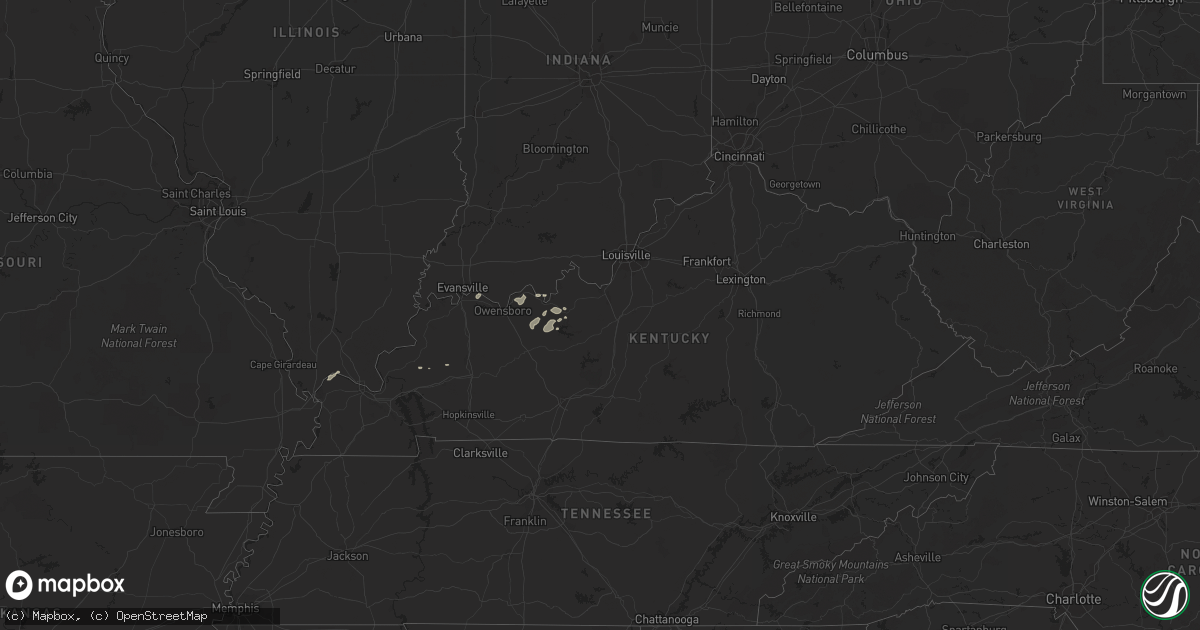
Hail Map in Kentucky on August 15, 2018
Get this storm
August 15 map
$229
one time, instant access
Download today. No call, no setup
Keep the $229
Bought the map and want the full workflow? Apply the entire $229 to a subscription within 7 days. None of it is wasted.
Every map, not just this one
This buys you this map. Subscription and you get every map we run, in the markets you choose from a few cities to whole states to nationwide. Plus real-time alerts the moment a storm fires.
Contact data
Name, contact info, occupancy, even credit band for addresses in the footprint. You go from where it hit to who to call.
Become the source they trust
Unlimited branding weather history reports on demand. You already have the documented answer ready for the property owner, and you are the one who showed up with it.
Property data and RoofTrace estimates
Pull up any address you have got, its value and the exact code rules for that jurisdiction, straight from One Click Code. Then RoofTrace estimates the squares, pitch, and roof value, priced the way you price.
Storm reports in Kentucky
Kentucky
| Date | Description |
|---|---|
| 08/15/20186:57 PM CDT | Power pole down along highway 477. |
| 08/15/20186:45 PM CDT | Trees down along highway 261 and over much of the western part of the county. |
| 08/15/20186:35 PM CDT | Metal roof blown off barn... Shed completely blown apart... Several chicken coops completely flattened... Multiple trees in a row blown over all in same direction. |
| 08/15/20186:28 PM CDT | Trees down. Dryer lifted and landed on car. |
| 08/15/20185:31 PM CDT | Trees and power lines down. |
| 08/15/20185:26 PM CDT | Trees down. |
| 08/15/20186:30 AM CDT | At 1130 PM CDT, a severe thunderstorm was located 12 miles northeast of Hartford, moving northeast at 40 mph. HAZARD...60 mph wind gusts. SOURCE...Automated Observing Station. At 1125 PM CDT...the Ohio County Kentucky Mesonet station reported a 60 mph wind gust. IMPACT...Expect damage to roofs, siding, and trees. Locations impacted include... Hardinsburg, Fordsville, Concord, Horse Branch, Mcquady, Se Ree, Shreve, Westview, Tousey and Magan. |
| 08/15/20183:12 AM CDT | At 811 PM EDT/711 PM CDT/, a severe thunderstorm was located 9 miles north of Leitchfield, moving east at 30 mph. HAZARD...60 mph wind gusts. SOURCE...Radar indicated. IMPACT...Expect damage to roofs, siding, and trees. Locations impacted include... Leitchfield, Mcdaniels, Indian Valley, Constantine, Limp, Saint Paul, Hudson, Cobblers Knob, Solway and Tar Hill. |
| 08/15/20182:22 AM CDT | At 721 PM EDT, severe thunderstorms were located along a line extending from near Bedford to 10 miles west of Salem to 9 miles east of English to 6 miles south of Carefree Town, moving northeast at 35 mph. HAZARD...60 mph wind gusts. SOURCE...Radar indicated. IMPACT...Expect damage to roofs, siding, and trees. Locations impacted include... Salem, Carefree Town, Palmyra, Milltown, Campbellsburg, Hardinsburg, Leavenworth, Livonia, Saltillo and Fredericksburg. |
| 08/15/20182:05 AM CDT | At 703 PM EDT/603 PM CDT/, severe thunderstorms were located along a line extending from near Shoals to near Paoli to 6 miles southwest of English to near Tell City, moving northeast at 30 mph. Winds gusted to 67 mph at French Lick as the storm went through. HAZARD...70 mph wind gusts. SOURCE...Radar indicated. IMPACT...Expect considerable tree damage. Damage is likely to mobile homes, roofs, and outbuildings. Locations impacted include... Tell City, Paoli, English, Carefree Town, Mount Pleasant, Orleans, French Lick, Stampers Creek, Marengo and Milltown. |
| 08/14/201811:47 PM CDT | At 447 PM CDT, severe thunderstorms were located along a line extending from near Lynnville to Stanley, moving east at 35 mph. HAZARD...60 mph wind gusts and penny size hail. SOURCE...Radar indicated. IMPACT...Expect damage to roofs, siding, and trees. Locations impacted include... Evansville, Owensboro, Boonville, Newburgh, Chandler, Rockport, Dale, Lynnville, Grandview, Knottsville, Folsomville, Stanley, Holiday World, Eureka, Elberfeld, Chrisney, Tennyson and Gentryville. |
| 08/14/201811:25 PM CDT | Measured at ohio county mesonet station. |
| 08/14/201810:02 PM CDT | At 302 PM CDT, a severe thunderstorm was located near Rosiclare, or 17 miles northwest of Marion, moving northeast at 35 mph. HAZARD...60 mph wind gusts and penny size hail. SOURCE...Radar indicated. IMPACT...Expect damage to roofs, siding, and trees. Locations impacted include... Rosiclare, Cave-in-Rock, Elizabethtown, Carrsville and Gross. |
| 08/14/20189:14 PM CDT | At 213 PM CDT, a severe thunderstorm was located near Charleston, moving northeast at 50 mph. HAZARD...60 mph wind gusts. SOURCE...Radar indicated. IMPACT...Expect damage to roofs, siding, and trees. Locations impacted include... Charleston, Cairo, Wickliffe, Mounds, Mound City, Horseshoe Lake Conservation Area, Diehlstadt and Wilson City. |
| 08/14/20187:27 PM CDT | Trees down in the 1600 block of loney lane. |
All States Impacted by Hail Map on August 15, 2018
Cities Impacted by Hail Map on August 15, 2018
- Bartlett, NE
- Ericson, NE
- Chambers, NE
- Sundance, WY
- Mountain Center, CA
- Ainsworth, NE
- Johnstown, NE
- Lake Clear, NY
- Saranac Lake, NY
- Thurston, NE
- Pender, NE
- Hereford, TX
- Tulia, TX
- Kress, TX
- Plainview, TX
- Clayton, NY
- Scotia, NE
- Ord, NE
- Silverton, TX
- Burwell, NE
- Saint Paul, NE
- Farwell, NE
- Dannebrog, NE
- Happy, TX
- Baton Rouge, LA
- Arthur, NE
- Wagon Mound, NM
- Houlton, ME
- Sutherland, NE
- Saint Libory, NE
- Grand Island, NE
- Theresa, NY
- La Fargeville, NY
- Alexandria Bay, NY
- Bristol, VT
- New Haven, VT
- Middlebury, VT
- Okabena, MN
- Lakefield, MN
- North Platte, NE
- Tell City, IN
- Weston, CO
- Friona, TX
- Summerfield, TX
- Loup City, NE
- Wood Lake, NE
- Greeley, NE
- Taylor, NE
- Hayes Center, NE
- Osseo, WI
- Martin, SD
- Allen, SD
- Batesland, SD
- Elsmere, NE
- Eagle Lake, ME
- Conchas Dam, NM
- Trementina, NM
- Eustis, NE
- Maxwell, NE
- Hershey, NE
- Farnam, NE
- Moorefield, NE
- Brady, NE
- Paxton, NE
- Kevil, KY
- Grand Chain, IL
- La Center, KY
- High Springs, FL
- Limestone, ME
- Des Moines, NM
- Brule, NE
- Ogallala, NE
- Big Springs, NE
- Spearman, TX
- Peyton, CO
- Calhan, CO
- Hot Springs, SD
- Bassett, NE
- Long Pine, NE
- Ashby, NE
- Hyannis, NE
- Pine Valley, CA
- Karval, CO
- Colorado Springs, CO
- Reed, KY
- Bucksport, ME
- Wayside, TX
- Comstock, NE
- Sargent, NE
- Broken Bow, NE
- Orland, ME
- Harned, KY
- Hawesville, KY
- Cannelton, IN
- Dimmitt, TX
- Dickens, NE
- Wallace, NE
- Custer, SD
- Mills, NE
- Falls Of Rough, KY
- Adrian, MN
- Oelrichs, SD
- Elba, NE
- Ashton, NE
- Nara Visa, NM
- Campo, CA
- Boulevard, CA
- Edgemont, SD
- Bingham, NE
- Saint Gabriel, LA
- Grand Isle, ME
- Pine Ridge, SD
- Smithwick, SD
- Ashland, ME
- Oxford, AL
- Texhoma, OK
- Goodwell, OK
- Reynolds Station, KY
- Cloverport, KY
- Sikeston, MO
- Bushnell, FL
- Gothenburg, NE
- Lincolnville, ME
- Islesboro, ME
- Emerson, NE
- Cozad, NE
- Humphrey, NE
- Leigh, NE
- Creston, NE
- Platte Center, NE
- Columbus, NE
- Lindsay, NE
- Broadview, NM
- Nebo, KY
- Broseley, MO
- Ambrose, GA
- Wray, GA
- Broxton, GA
- Springview, NE
- Fairchild, WI
- Wilmington, NY
- Hardinsburg, KY
- Surry, ME
- Ellsworth, ME
- Trenton, FL
- Kim, CO
- Madison, NE
- Van Buren, ME
- Hammond, NY
- Redwood, NY
- Thedford, NE
- Las Animas, CO
- Oral, SD
- Whitesville, KY
- Fordsville, KY
- Canadian, TX
- Wounded Knee, SD
- Oglala, SD
- Manderson, SD
- Edgerton, MN
- Amelia, NE
- Gouverneur, NY
- Newman Grove, NE
- Palmer, NE
- Boelus, NE
- North Loup, NE
- Perryton, TX
- Cape Vincent, NY
- Arcadia, NE
- Fredonia, KY
- Marion, KY
- Brooksville, FL
- Chapman, NE
- Winterport, ME
- Rushville, NE
- Newberry, FL
- Bloomingdale, NY
- Westview, KY
- Metropolis, IL
- Belknap, IL
- Punta Gorda, FL
- Cairo, NE
- Childress, TX
- Qulin, MO
- Tuthill, SD
- Danville, AR
- Valentine, NE
- Palomar Mountain, CA
- Willsboro, NY
- Edgewood, NM
- Parker, AZ
- Morrill, ME
- Grenville, NM
- Newport, NE
- Dexter, NY
- Chaumont, NY
- Watertown, NY
- Caribou, ME
- Gordon, NE
- Lewisport, KY
- Maceo, KY
- Philpot, KY
- Tryon, NE


