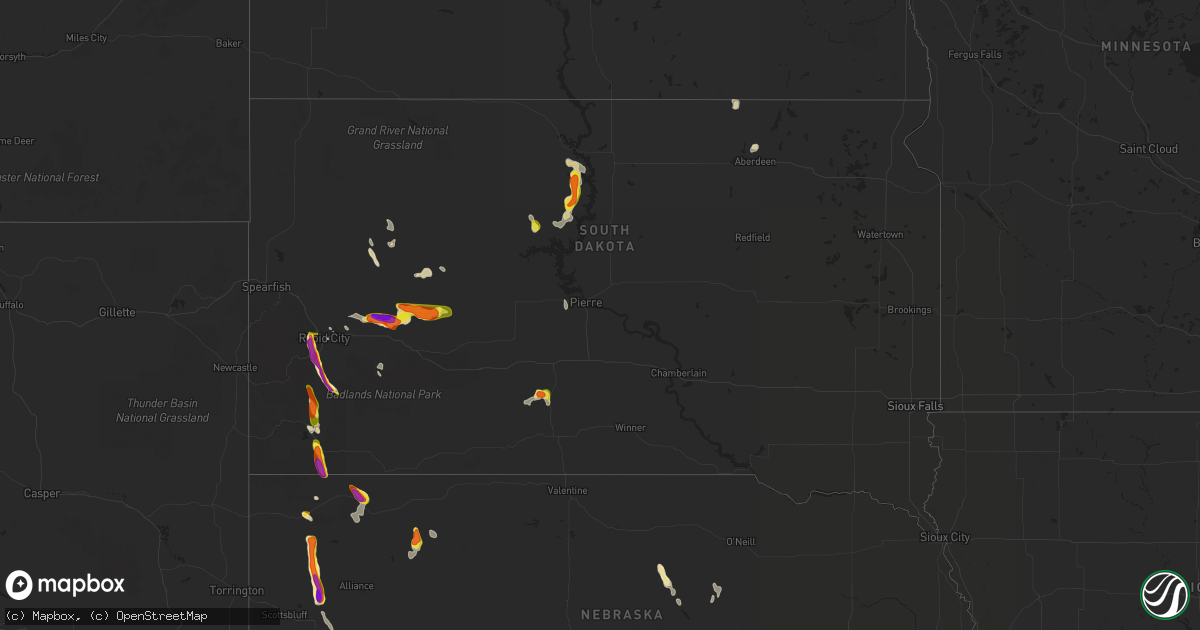
Hail Map in South Dakota on August 14, 2021
Get this storm
August 14 map
$229
one time, instant access
Download today. No call, no setup
Keep the $229
Bought the map and want the full workflow? Apply the entire $229 to a subscription within 7 days. None of it is wasted.
Every map, not just this one
This buys you this map. Subscription and you get every map we run, in the markets you choose from a few cities to whole states to nationwide. Plus real-time alerts the moment a storm fires.
Contact data
Name, contact info, occupancy, even credit band for addresses in the footprint. You go from where it hit to who to call.
Become the source they trust
Unlimited branding weather history reports on demand. You already have the documented answer ready for the property owner, and you are the one who showed up with it.
Property data and RoofTrace estimates
Pull up any address you have got, its value and the exact code rules for that jurisdiction, straight from One Click Code. Then RoofTrace estimates the squares, pitch, and roof value, priced the way you price.
Storm reports in South Dakota
South Dakota
| Date | Description |
|---|---|
| 08/14/20216:57 PM CDT | A local report indicates 1.00 inch wind near 8 SW WEST SHORE REC ARE |
| 08/14/20216:50 PM CDT | Still hailing |
| 08/14/20215:50 PM CDT | Quarter to half dollar sized hail |
| 08/14/20215:20 PM CDT | A local report indicates 1.50 inch wind near 3 NNE CREIGHTON |
| 08/14/20214:46 PM CDT | A local report indicates 2.00 inch wind near 5 NNW FAIRBURN |
| 08/14/20214:40 PM CDT | A local report indicates 1.50 inch wind near 6 SSW ELM SPRINGS |
| 08/14/20214:30 PM CDT | Lots of damage to vehicles. Hail began around 330 pm and continued until 345 pm. |
| 08/14/20214:25 PM CDT | A local report indicates 1.10 inch wind near 3 WSW HERMOSA |
| 08/14/20214:15 PM CDT | A local report indicates 1.00 inch wind near 11 WSW ELM SPRINGS |
| 08/14/20214:15 PM CDT | Hail lasted 15-20 minutes. Began around 315 pm and ended 330 pm. |
| 08/14/20213:49 PM CDT | No rain |
| 08/14/20213:40 PM CDT | A local report indicates 2.00 inch wind near 2 E ROCKERVILLE |
| 08/14/20213:40 PM CDT | A local report indicates 1.00 inch wind near 2 ENE ROCKERVILLE |
| 08/14/20213:38 PM CDT | A local report indicates 1.75 inch wind near 4 NE ROCKERVILLE |
| 08/14/20213:33 PM CDT | A local report indicates 1.00 inch wind near 4 NE ROCKERVILLE |
| 08/14/20213:25 PM CDT | Nickel to quarter hail |
| 08/14/20213:10 PM CDT | A local report indicates 1.00 inch wind near 3 SSW ORAL |
| 08/14/20212:35 PM CDT | Ground is white from the hail |
| 08/14/20212:20 PM CDT | Dime to nickel hail. |
| 08/14/20217:45 AM CDT | At 1245 PM MDT, a severe thunderstorm was located 5 miles southeast of Buffalo Corrals, or 13 miles northeast of Hot Springs, moving southeast at 15 mph. HAZARD...Ping pong ball size hail and 60 mph wind gusts. SOURCE...Radar indicated. IMPACT...People and animals outdoors will be injured. Expect hail damage to roofs, siding, windows, and vehicles. Expect wind damage to roofs, siding, and trees. Locations impacted include... Buffalo Gap. |
| 08/14/20213:48 AM CDT | At 847 PM CDT/747 PM MDT/, a severe thunderstorm was located 13 miles south of Ridgeview, or 18 miles east of Eagle Butte, moving south at 20 mph. HAZARD...Ping pong ball size hail and 60 mph wind gusts. SOURCE...Radar indicated. IMPACT...People and animals outdoors will be injured. Expect hail damage to roofs, siding, windows, and vehicles. Expect wind damage to roofs, siding, and trees. This severe thunderstorm will be near... Mission Ridge around 830 PM MDT.Other locations impacted by this severe thunderstorm include easternCheyenne River Reservation. |
| 08/14/20213:15 AM CDT | At 814 PM CDT/714 PM MDT/, a severe thunderstorm was located near Swiftbird Day School, or 27 miles west of Gettysburg, moving south at 15 mph. HAZARD...60 mph wind gusts and half dollar size hail. SOURCE...Radar indicated. IMPACT...Hail damage to vehicles is expected. Expect wind damage to roofs, siding, and trees. This severe thunderstorm will be near... Swiftbird Day School around 730 PM MDT.Other locations in the path of this severe thunderstorm includeSwiftbird. |
| 08/14/20212:29 AM CDT | At 729 PM CDT/629 PM MDT/, a severe thunderstorm was located near Blackfoot, or 17 miles south of Mobridge, moving south at 15 mph. HAZARD...Ping pong ball size hail and 60 mph wind gusts. SOURCE...Radar indicated. IMPACT...People and animals outdoors will be injured. Expect hail damage to roofs, siding, windows, and vehicles. Expect wind damage to roofs, siding, and trees. This severe thunderstorm will remain over mainly rural areas of northwestern Potter and northeastern Dewey Counties. |
| 08/14/20212:12 AM CDT | At 712 PM CDT, a severe thunderstorm was located 8 miles northwest of Swift Bear, or 9 miles northwest of White River, moving west at 5 mph. HAZARD...Quarter size hail. SOURCE...Radar indicated. IMPACT...Damage to vehicles is expected. This severe thunderstorm will remain over mainly rural areas of central Mellette County, between Cedar Butte and Wood. |
| 08/14/20211:47 AM CDT | At 646 PM CDT/546 PM MDT/, a severe thunderstorm was located near Blackfoot, or 11 miles southeast of Mobridge, moving east at 20 mph. HAZARD...60 mph wind gusts and quarter size hail. SOURCE...Radar indicated. IMPACT...Hail damage to vehicles is expected. Expect wind damage to roofs, siding, and trees. This severe thunderstorm will be near... New Everets Resort around 655 PM CDT. Swan Creek Rec Area around 705 PM CDT.Other locations in the path of this severe thunderstorm includeAkaska. |
| 08/14/20211:34 AM CDT | At 634 PM CDT, a severe thunderstorm was located 5 miles east of White River, and is nearly stationary. HAZARD...Quarter size hail. SOURCE...Radar indicated. IMPACT...Damage to vehicles is expected. Locations impacted include... Wood and Butte Creek. |
| 08/13/202111:40 PM CDT | At 440 PM MDT, a severe thunderstorm was located 9 miles north of Grindstone, or 22 miles northwest of Philip, moving east at 20 mph. HAZARD...Ping pong ball size hail. SOURCE...Trained weather spotters. IMPACT...People and animals outdoors will be injured. Expect damage to roofs, siding, windows, and vehicles. Locations impacted include... Grindstone Butte. |
| 08/13/202111:04 PM CDT | At 404 PM MDT, a severe thunderstorm was located 3 miles northwest of Creighton, or 33 miles northwest of Philip, moving east at 15 mph. HAZARD...Ping pong ball size hail and 60 mph wind gusts. SOURCE...Radar indicated. IMPACT...People and animals outdoors will be injured. Expect hail damage to roofs, siding, windows, and vehicles. Expect wind damage to roofs, siding, and trees. This severe thunderstorm will be near... Creighton around 415 PM MDT. |
| 08/13/202110:30 PM CDT | At 329 PM MDT, a severe thunderstorm was located 5 miles south of Elm Springs, or 36 miles east of Rapid City, moving east at 15 mph. HAZARD...Two inch hail. SOURCE...Radar indicated. IMPACT...People and animals outdoors will be injured. Expect damage to roofs, siding, windows, and vehicles. This severe thunderstorm will be near... Elm Springs around 335 PM MDT. |
| 08/13/202110:24 PM CDT | At 324 PM MDT, a severe thunderstorm was located 5 miles southwest of Hermosa, or 18 miles east of Custer, moving south at 20 mph. HAZARD...Two inch hail. SOURCE...Radar indicated. IMPACT...People and animals outdoors will be injured. Expect damage to roofs, siding, windows, and vehicles. Locations impacted include... Fairburn. |
| 08/13/202110:05 PM CDT | At 305 PM MDT, a severe thunderstorm was located near Curlew Lake, or 27 miles northeast of Rapid City, moving east at 15 mph. HAZARD...Quarter size hail. SOURCE...Radar indicated. IMPACT...Damage to vehicles is expected. This severe thunderstorm will remain over mainly rural areas of south central Meade County, just west of Elm Springs. |
| 08/13/20219:44 PM CDT | At 243 PM MDT, a severe thunderstorm was located 6 miles southwest of Viewfield, or 16 miles northeast of Rapid City, moving southeast at 15 mph. HAZARD...60 mph wind gusts and quarter size hail. SOURCE...Radar indicated. IMPACT...Hail damage to vehicles is expected. Expect wind damage to roofs, siding, and trees. Locations impacted include... New Underwood and Caputa.This includes Interstate 90 in South Dakota between Mile Markers 69and 89. |
| 08/13/20219:37 PM CDT | At 236 PM MDT, a severe thunderstorm was located near Rockerville, or 9 miles southwest of Rapid City, moving south at 15 mph. HAZARD...60 mph wind gusts and half dollar size hail. SOURCE...Radar indicated. IMPACT...Hail damage to vehicles is expected. Expect wind damage to roofs, siding, and trees. This severe thunderstorm will be near... Hayward around 255 PM MDT.Other locations in the path of this severe thunderstorm includeHermosa and State Game Lodge. |
| 08/13/20219:06 PM CDT | At 206 PM MDT, a severe thunderstorm was located 3 miles northwest of Smithwick, or 12 miles southeast of Hot Springs, moving south at 15 mph. HAZARD...60 mph wind gusts and quarter size hail. SOURCE...Radar indicated. IMPACT...Hail damage to vehicles is expected. Expect wind damage to roofs, siding, and trees. This severe thunderstorm will be near... Smithwick around 220 PM MDT.Other locations in the path of this severe thunderstorm include HayCanyon Butte and Oelrichs. |
| 08/13/20218:57 PM CDT | At 157 PM MDT, a severe thunderstorm was located 4 miles south of Black Hawk, or 4 miles northwest of Rapid City, and is nearly stationary. HAZARD...60 mph wind gusts and quarter size hail. SOURCE...Radar indicated. IMPACT...Hail damage to vehicles is expected. Expect wind damage to roofs, siding, and trees. Locations impacted include... Rapid City, southwestern Rapid Valley, Reptile Gardens and Bear Country.This includes Interstate 90 in South Dakota between Mile Markers 49and 60. |
| 08/13/20218:40 PM CDT | A local report indicates 1.50 inch wind near 5 ESE LAPLANT |
| 08/13/20218:28 PM CDT | At 128 PM MDT, a severe thunderstorm was located over Buffalo Gap, or 9 miles northeast of Hot Springs, moving south at 10 mph. HAZARD...60 mph wind gusts and half dollar size hail. SOURCE...Radar indicated. IMPACT...Hail damage to vehicles is expected. Expect wind damage to roofs, siding, and trees. Locations impacted include... Maverick Junction and Oral. |
| 08/13/20217:25 PM CDT | Dime to quarter hail |
| 08/13/20217:00 PM CDT | Pea hail to ping pong ball sized... Irregular shape. |
All States Impacted by Hail Map on August 14, 2021
Cities Impacted by Hail Map on August 14, 2021
- Arcadia, NE
- Minden, NE
- Fredonia, ND
- Lehr, ND
- Middlesboro, KY
- Chadron, NE
- Wall, SD
- Hermosa, SD
- Waxhaw, NC
- Owanka, SD
- Rapid City, SD
- Juniata, NE
- Wood River, NE
- Hastings, NE
- Wasta, SD
- Nacogdoches, TX
- Cheyenne, WY
- Marion, NC
- Union Mills, NC
- Sedgwick, CO
- Oshkosh, NE
- Keystone, SD
- Hillsdale, WY
- Nunn, CO
- Bogue, KS
- Palco, KS
- Eagle Butte, SD
- Elm Creek, NE
- Charles City, VA
- Petersburg, VA
- Bridgeport, NE
- Ashley, ND
- Ellerbe, NC
- Elsie, NE
- Madrid, NE
- Hayes Center, NE
- Hildreth, NE
- Ellis, KS
- Brownell, KS
- Ogallah, KS
- Wakeeney, KS
- Hill City, KS
- Fort Pierre, SD
- Cary, NC
- Morrisville, NC
- Oelrichs, SD
- Bayard, NE
- Hemingford, NE
- Alliance, NE
- Keysville, VA
- Statesville, NC
- Olin, NC
- Harmony, NC
- Ogallala, NE
- Milesville, SD
- New Underwood, SD
- Philip, SD
- Paxton, NE
- Wallace, NE
- Frederick, SD
- Leola, SD
- Mud Butte, SD
- Grand Island, NE
- Monticello, GA
- Burwell, NE
- Gary, TX
- Timpson, TX
- Ansley, NE
- Buckingham, VA
- Charlotte, NC
- Fort Mill, SC
- Pineville, NC
- Williamsburg, VA
- Alton, VA
- South Boston, VA
- Miller, NE
- Amherst, NE
- Bassett, NE
- Haddock, GA
- Lake Village, AR
- Dermott, AR
- Dillwyn, VA
- White River, SD
- Emporia, VA
- Charlottesville, VA
- Afton, VA
- North Garden, VA
- Crozet, VA
- Greenwood, VA
- Pendleton, SC
- Naytahwaush, MN
- Waubun, MN
- Merriman, NE
- Meherrin, VA
- Norton, TX
- Ballinger, TX
- Sterling, CO
- Merino, CO
- Russellville, KY
- Bucksport, ME
- Chapman, NE
- Bangs, TX
- Ivor, VA
- Smithfield, VA
- Windsor, VA
- Scottsville, KY
- Max Meadows, VA
- Colorado City, AZ
- Union Center, SD
- Browns Summit, NC
- Hot Springs, SD
- Oral, SD
- Whitney, NE
- Chappell, NE
- Ovid, CO
- Phillipsburg, KS
- Scenic, SD
- Kenesaw, NE
- Hay Springs, NE
- Hawley, MN
- Lenoir, NC
- Granite Falls, NC
- Hudson, NC
- Morganton, NC
- Youngstown, FL
- Orleans, NE
- Central, UT
- Newberry, SC
- Pomaria, SC
- Whitmire, SC
- Raleigh, NC
- Jamestown, KY
- Quinlan, TX
- Panama City Beach, FL
- Ebro, FL
- Oak Grove, LA
- Pine Valley, UT
- Mooresburg, TN
- Rogersville, TN
- Poquoson, VA
- Hampton, VA
- Leslie, GA
- Americus, GA
- Onset, MA
- Buzzards Bay, MA
- East Wareham, MA
- Carpenter, WY
- Akron, CO
- Atwood, CO
- Gackle, ND
- Fairburn, SD
- Buffalo Gap, SD
- Holdrege, NE
- Padroni, CO
- Ville Platte, LA
- Gloucester, VA
- Hayes, VA
- Spring Hope, NC
- Middlesex, NC
- Overton, NE
- York, SC
- Rock Hill, SC
- Rice, VA
- Farmville, VA
- Green Bay, VA
- Ivanhoe, VA
- Fries, VA
- Auburn, KY
- Knightdale, NC
- Hays, KS
- Bronte, TX
- Saint George, UT
- Washington, UT
- Drakes Branch, VA
- Saxe, VA
- Monroe, NC
- Long Branch, TX
- Carthage, TX
- Aberdeen, SD
- White Plains, MD
- La Plata, MD
- Pomfret, MD
- Belton, KY
- Durham, NC
- Ponce De Leon, FL
- Vernon, FL
- Bowling Green, KY
- Bingham, NE
- Gordon, NE
- Winston Salem, NC
- Peachland, NC
- Loomis, NE
- Sutherland, NE
- Saint Libory, NE
- Nebo, NC
- Wendell, NC
- Richmond, VA
- Fletcher, NC
- Fairview, NC
- Asheville, NC
- Greenwood, SC
- Prince George, VA
- Hopewell, VA
- Prairie View, KS
- Long Island, KS
- Hermitage, AR
- Norwood, GA
- Warrenton, GA
- Sparta, GA
- Stamford, NE
- Sedley, VA
- Courtland, VA
- May, TX
- North Loup, NE
- Lincolnton, NC
- Box Elder, SD
- Heartwell, NE
- Wakefield, VA
- Dalton, NE
- McCracken, KS
- Caputa, SD
- Burkeville, VA
- Wilcox, NE
- Capron, VA
- Victoria, VA
- Elberon, VA
- Burns, WY
- Abbeville, SC
- Calhoun Falls, SC
- Iva, SC
- Milton, FL
- Spring Grove, VA
- Almena, KS
- Marshville, NC
- Rockfield, KY
- Crewe, VA
- Piedmont, SC
- Gray Court, SC
- Enoree, SC
- Walland, TN
- Fort Worth, TX
- Huntington, TX
- Waldorf, MD
- Crawford, NE
- Tenaha, TX
- Grover, CO
- Bristol, FL
- Enterprise, UT
- Eaton, CO
- Greeley, CO
- Gill, CO
- Ault, CO
- Litchfield, NE
- Mason City, NE
- Marsland, NE
- Ashton, NE
- Trumbull, NE
- Disputanta, VA
- Carson, VA
- Fort Eustis, VA
- Newport News, VA
- Cherry Creek, SD
- Union, SC
- Angora, NE
- Eagle Springs, NC
- Albany, GA
- Leesburg, GA
- McKenney, VA
- Zebulon, NC
- Sanford, NC
- Freeport, FL
- Barnesville, MN
- Winters, TX
- Virginia Beach, VA
- Candor, NC
- Tellico Plains, TN
- Washington, GA
- Crawfordville, GA
- Panama City, FL
- Reidsville, NC
- Wewahitchka, FL
- Howes, SD
- Monticello, AR
- Polkton, NC
- Logan, KS
- Franklin, VA
- Zuni, VA
- Chester, SC
- Graham, NC
- Mebane, NC
- Haw River, NC
- Ruther Glen, VA
- Center, TX
- Ord, NE
- Plum Branch, SC
- Pageland, SC
- Streeter, ND
- Stockton Springs, ME
- Frankfort, ME
- Smithville, GA
- Amelia, NE
- Athens, TX
- El Dorado, AR
- Norfolk, VA
- Providence Forge, VA
- Waverly, VA
- Yale, VA
- Sidney, NE
- Apex, NC
- Holly Springs, NC
- Elba, NE
- Chappell, KY
- Bledsoe, KY
- Baxter, KY
- Chase City, VA
- Williamston, SC
- Easley, SC
- Pelzer, SC
- Oxford, NE
- Santa Anna, TX
- Brownwood, TX
- Draper, VA
- Pamplin, VA
- Waxahachie, TX
- State Road, NC
- Duffield, VA
- Dallas, TX
- Dobson, NC
- Sheridan, AR
- Oakland, KY
- Smiths Grove, KY
- Cleveland, SC
- Upland, NE
- Blair, SC
- Branchville, VA
- Maryville, TN
- Rockford, TN
- Carthage, NC
- Hampden Sydney, VA
- Jay, FL
- Laurens, SC
- Sumner, NE
- Surry, VA
- Dendron, VA
- Campti, LA
- Yorktown, VA
- Scottsville, VA
- Ellsworth, NE
- Wake Forest, NC
- Trinity, TX
- Henrico, VA
- Matthews, NC
- Indian Trail, NC
- Randolph, VA
- Knoxville, TN
- Keystone, NE
- Grant, NE
- Suffolk, VA


