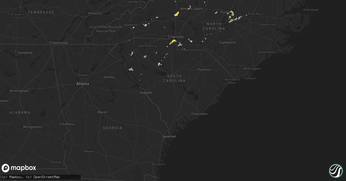
Hail Map in South Carolina on August 14, 2021
Get this storm
August 14 map
$229
one time, instant access
Download today. No call, no setup
Keep the $229
Bought the map and want the full workflow? Apply the entire $229 to a subscription within 7 days. None of it is wasted.
Every map, not just this one
This buys you this map. Subscription and you get every map we run, in the markets you choose from a few cities to whole states to nationwide. Plus real-time alerts the moment a storm fires.
Contact data
Name, contact info, occupancy, even credit band for addresses in the footprint. You go from where it hit to who to call.
Become the source they trust
Unlimited branding weather history reports on demand. You already have the documented answer ready for the property owner, and you are the one who showed up with it.
Property data and RoofTrace estimates
Pull up any address you have got, its value and the exact code rules for that jurisdiction, straight from One Click Code. Then RoofTrace estimates the squares, pitch, and roof value, priced the way you price.
Storm reports in South Carolina
South Carolina
| Date | Description |
|---|---|
| 08/14/20214:12 PM CDT | Newberry co sheriffs office reports tree down on whitmire hwy and beth eden rd. |
| 08/14/20213:20 PM CDT | 911 call center reported trees and powerlines down on mcfadden st |
| 08/14/20212:53 PM CDT | Amateur radio reported tree down on a house on malvern rd. |
| 08/14/20212:45 PM CDT | 911 call center reported trees down on liberty hwy near i-85 |
| 08/14/20212:45 PM CDT | A few trees blown down in the county. No area with a concentration of trees down. The point was under where the strongest storm core occurred. |
| 08/14/20212:41 PM CDT | Emergency mngr reported trees down on morgan st. |
| 08/14/20212:41 PM CDT | Emergency mngr reported trees down on blue jay pass. |
| 08/14/20212:40 PM CDT | 911 call center reported trees down on edgewood ave and glenwood ave |
| 08/14/20212:30 PM CDT | 911 call center reported powerlines down on rm boseman rd off of hwy 252 |
| 08/14/20212:30 PM CDT | Public reported trees snapped and uprooted on spinnaker dr |
| 08/14/20212:30 PM CDT | Public reported trees down on lake wylie dr at ebenezer park. |
| 08/14/20212:23 PM CDT | 911 call center reported trees down on ora rd & us-221 |
| 08/14/20212:20 PM CDT | Public reported large tree limbs down on hart st. |
| 08/14/20212:19 PM CDT | Emergency mngr reported tree down on a house on creek bluff rd. |
| 08/14/20212:15 PM CDT | 911 call center reported trees down on cherokee rd |
| 08/14/20212:15 PM CDT | 911 call center reported trees and powerlines down on osborne st |
| 08/14/20212:15 PM CDT | 911 call center reported a tree down on a home on beltline rd |
| 08/14/20212:09 PM CDT | Emergency mngr reported tree down on a house on sweetgum dr |
| 08/14/20211:50 PM CDT | 911 call center reported powerlines down on mayfield heights rd |
| 08/13/202111:45 PM CDT | At 444 PM EDT, a severe thunderstorm was located near Blair, or 10 miles northwest of VC Summer Nuclear Station, moving north at 10 mph. HAZARD...60 mph wind gusts and penny size hail. SOURCE...Radar indicated. IMPACT...Expect damage to roofs, siding, and trees. Locations impacted include... Whitmire, Blair, Maybington Fire Station, US-176 and SC- 34 Crossroads, Feasterville Fire Station, Henderson Island and Enoree Ranger District Office. |
| 08/13/202110:56 PM CDT | At 356 PM EDT, a severe thunderstorm was located 8 miles south of Chester, or 5 miles northwest of Blackstock, moving north at 5 mph. HAZARD...60 mph wind gusts and quarter size hail. SOURCE...Radar indicated. IMPACT...Minor hail damage to vehicles is expected. Expect wind damage to trees and power lines. Locations impacted include... Chester, Richburg, Chester State Park, Blackstock, Cornwell and Lowrys. |
| 08/13/202110:39 PM CDT | At 339 PM EDT, a severe thunderstorm was located 4 miles west of Monroe, or near Wesley Chapel, moving west at 5 mph. HAZARD...60 mph wind gusts and quarter size hail. SOURCE...Radar indicated. IMPACT...Minor hail damage to vehicles is expected. Expect wind damage to trees and power lines. Locations impacted include... Monroe, Matthews, Indian Trail, Weddington, Stallings, Unionville, Wesley Chapel, Wingate, Waxhaw and Lake Park. |
| 08/13/202110:22 PM CDT | At 322 PM EDT, a severe thunderstorm was located 9 miles south of Easley, or 8 miles southeast of Liberty, moving east at 5 mph. HAZARD...60 mph wind gusts and quarter size hail. SOURCE...Radar indicated. IMPACT...Minor hail damage to vehicles is expected. Expect wind damage to trees and power lines. Locations impacted include... Anderson, Piedmont, Belton, Williamston, Northlake, West Pelzer, Sandy Springs, Pendleton, Homeland Park and Powdersville. |
| 08/13/202110:18 PM CDT | At 318 PM EDT, a severe thunderstorm was located 6 miles north of Laurens, or 5 miles east of Gray Court, moving east at 5 mph. HAZARD...60 mph wind gusts and quarter size hail. SOURCE...Radar indicated. IMPACT...Minor hail damage to vehicles is expected. Expect wind damage to trees and power lines. Locations impacted include... Laurens, Woodruff, Gray Court, Mountville, Cross Keys, Cross Anchor, Enoree, Ora and Clinton. |
| 08/13/202110:13 PM CDT | At 313 PM EDT, a severe thunderstorm was located 7 miles northwest of Indian Land, or near Tega Cay, moving southwest at 10 mph. HAZARD...60 mph wind gusts and quarter size hail. SOURCE...Radar indicated. IMPACT...Minor hail damage to vehicles is expected. Expect wind damage to trees and power lines. Locations impacted include... Rock Hill, South Charlotte, Southwest Charlotte, Fort Mill, Pineville, Tega Cay, Newport, Lesslie, Steele Creek and The Arboretum. |
| 08/13/202110:11 PM CDT | At 311 PM EDT, a severe thunderstorm was located 7 miles northwest of Abbeville, or 6 miles southeast of Lake Secession, moving northeast at 10 mph. HAZARD...60 mph wind gusts and quarter size hail. SOURCE...Radar indicated. IMPACT...Minor hail damage to vehicles is expected. Expect wind damage to trees and power lines. Locations impacted include... Abbeville, Due West, Lake Secession, Donalds, Shoals Junction, Antreville and Hodges. |
| 08/13/202110:09 PM CDT | At 309 PM EDT, a severe thunderstorm was located near Union, or over Monarch Mill, and is nearly stationary. HAZARD...60 mph wind gusts and quarter size hail. SOURCE...Radar indicated. IMPACT...Minor hail damage to vehicles is expected. Expect wind damage to trees and power lines. Locations impacted include... Union, Monarch Mill, Buffalo, Lockhart, Adamsburg and Santuc. |
| 08/13/202110:04 PM CDT | At 304 PM EDT, a severe thunderstorm was located 10 miles southeast of Brevard, or near Jones Gap State Park, moving east at 10 mph. HAZARD...60 mph wind gusts and quarter size hail. SOURCE...Radar indicated. IMPACT...Minor hail damage to vehicles is expected. Expect wind damage to trees and power lines. Locations impacted include... Flat Rock, Tigerville, Pleasant Ridge State Park, Jones Gap State Park, Dupont State Forest, Caesars Head State Park, Tuxedo, North Saluda Reservoir, Glassy Mountain and Crab Creek. |
| 08/13/20219:47 PM CDT | At 247 PM EDT, a severe thunderstorm was located 10 miles southeast of Easley, or near Piedmont, moving south at 10 mph. HAZARD...60 mph wind gusts and quarter size hail. SOURCE...Radar indicated. IMPACT...Minor hail damage to vehicles is expected. Expect wind damage to trees and power lines. Locations impacted include... Piedmont, Belton, Williamston, West Pelzer, Anderson, Donaldson Center and Powdersville. |
| 08/13/20219:33 PM CDT | At 233 PM EDT, a severe thunderstorm was located 6 miles northeast of Indian Land, or near The Arboretum, moving west at 10 mph. HAZARD...60 mph wind gusts and quarter size hail. SOURCE...Radar indicated. IMPACT...Minor hail damage to vehicles is expected. Expect wind damage to trees and power lines. Locations impacted include... Central Charlotte, South Charlotte, Southwest Charlotte, Matthews, Weddington, Pineville, Freedom Park, Steele Creek, The Arboretum and Carowinds. |
| 08/13/20219:28 PM CDT | At 228 PM EDT, a severe thunderstorm was located 10 miles south of Greenwood, or 8 miles northeast of Troy, moving west at 10 mph. HAZARD...60 mph wind gusts and quarter size hail. SOURCE...Radar indicated. IMPACT...Minor hail damage to vehicles is expected. Expect wind damage to trees and power lines. Locations impacted include... Troy, Promised Land, Bradley, Kirksey, Callison, Epworth, Ninety Six and Greenwood. |
| 08/13/20219:13 PM CDT | At 213 PM EDT, a severe thunderstorm was located 8 miles northwest of Union, or near Jonesville, moving south at 10 mph. HAZARD...60 mph wind gusts and quarter size hail. SOURCE...Radar indicated. IMPACT...Minor hail damage to vehicles is expected. Expect wind damage to trees and power lines. Locations impacted include... Union, Buffalo, Jonesville, Rose Hill State Park, Cross Keys, Cross Anchor, Sedalia, Pacolet and Croft State Park. |
All States Impacted by Hail Map on August 14, 2021
Cities Impacted by Hail Map on August 14, 2021
- Arcadia, NE
- Minden, NE
- Fredonia, ND
- Lehr, ND
- Middlesboro, KY
- Chadron, NE
- Wall, SD
- Hermosa, SD
- Waxhaw, NC
- Owanka, SD
- Rapid City, SD
- Juniata, NE
- Wood River, NE
- Hastings, NE
- Wasta, SD
- Nacogdoches, TX
- Cheyenne, WY
- Marion, NC
- Union Mills, NC
- Sedgwick, CO
- Oshkosh, NE
- Keystone, SD
- Hillsdale, WY
- Nunn, CO
- Bogue, KS
- Palco, KS
- Eagle Butte, SD
- Elm Creek, NE
- Charles City, VA
- Petersburg, VA
- Bridgeport, NE
- Ashley, ND
- Ellerbe, NC
- Elsie, NE
- Madrid, NE
- Hayes Center, NE
- Hildreth, NE
- Ellis, KS
- Brownell, KS
- Ogallah, KS
- Wakeeney, KS
- Hill City, KS
- Fort Pierre, SD
- Cary, NC
- Morrisville, NC
- Oelrichs, SD
- Bayard, NE
- Hemingford, NE
- Alliance, NE
- Keysville, VA
- Statesville, NC
- Olin, NC
- Harmony, NC
- Ogallala, NE
- Milesville, SD
- New Underwood, SD
- Philip, SD
- Paxton, NE
- Wallace, NE
- Frederick, SD
- Leola, SD
- Mud Butte, SD
- Grand Island, NE
- Monticello, GA
- Burwell, NE
- Gary, TX
- Timpson, TX
- Ansley, NE
- Buckingham, VA
- Charlotte, NC
- Fort Mill, SC
- Pineville, NC
- Williamsburg, VA
- Alton, VA
- South Boston, VA
- Miller, NE
- Amherst, NE
- Bassett, NE
- Haddock, GA
- Lake Village, AR
- Dermott, AR
- Dillwyn, VA
- White River, SD
- Emporia, VA
- Charlottesville, VA
- Afton, VA
- North Garden, VA
- Crozet, VA
- Greenwood, VA
- Pendleton, SC
- Naytahwaush, MN
- Waubun, MN
- Merriman, NE
- Meherrin, VA
- Norton, TX
- Ballinger, TX
- Sterling, CO
- Merino, CO
- Russellville, KY
- Bucksport, ME
- Chapman, NE
- Bangs, TX
- Ivor, VA
- Smithfield, VA
- Windsor, VA
- Scottsville, KY
- Max Meadows, VA
- Colorado City, AZ
- Union Center, SD
- Browns Summit, NC
- Hot Springs, SD
- Oral, SD
- Whitney, NE
- Chappell, NE
- Ovid, CO
- Phillipsburg, KS
- Scenic, SD
- Kenesaw, NE
- Hay Springs, NE
- Hawley, MN
- Lenoir, NC
- Granite Falls, NC
- Hudson, NC
- Morganton, NC
- Youngstown, FL
- Orleans, NE
- Central, UT
- Newberry, SC
- Pomaria, SC
- Whitmire, SC
- Raleigh, NC
- Jamestown, KY
- Quinlan, TX
- Panama City Beach, FL
- Ebro, FL
- Oak Grove, LA
- Pine Valley, UT
- Mooresburg, TN
- Rogersville, TN
- Poquoson, VA
- Hampton, VA
- Leslie, GA
- Americus, GA
- Onset, MA
- Buzzards Bay, MA
- East Wareham, MA
- Carpenter, WY
- Akron, CO
- Atwood, CO
- Gackle, ND
- Fairburn, SD
- Buffalo Gap, SD
- Holdrege, NE
- Padroni, CO
- Ville Platte, LA
- Gloucester, VA
- Hayes, VA
- Spring Hope, NC
- Middlesex, NC
- Overton, NE
- York, SC
- Rock Hill, SC
- Rice, VA
- Farmville, VA
- Green Bay, VA
- Ivanhoe, VA
- Fries, VA
- Auburn, KY
- Knightdale, NC
- Hays, KS
- Bronte, TX
- Saint George, UT
- Washington, UT
- Drakes Branch, VA
- Saxe, VA
- Monroe, NC
- Long Branch, TX
- Carthage, TX
- Aberdeen, SD
- White Plains, MD
- La Plata, MD
- Pomfret, MD
- Belton, KY
- Durham, NC
- Ponce De Leon, FL
- Vernon, FL
- Bowling Green, KY
- Bingham, NE
- Gordon, NE
- Winston Salem, NC
- Peachland, NC
- Loomis, NE
- Sutherland, NE
- Saint Libory, NE
- Nebo, NC
- Wendell, NC
- Richmond, VA
- Fletcher, NC
- Fairview, NC
- Asheville, NC
- Greenwood, SC
- Prince George, VA
- Hopewell, VA
- Prairie View, KS
- Long Island, KS
- Hermitage, AR
- Norwood, GA
- Warrenton, GA
- Sparta, GA
- Stamford, NE
- Sedley, VA
- Courtland, VA
- May, TX
- North Loup, NE
- Lincolnton, NC
- Box Elder, SD
- Heartwell, NE
- Wakefield, VA
- Dalton, NE
- McCracken, KS
- Caputa, SD
- Burkeville, VA
- Wilcox, NE
- Capron, VA
- Victoria, VA
- Elberon, VA
- Burns, WY
- Abbeville, SC
- Calhoun Falls, SC
- Iva, SC
- Milton, FL
- Spring Grove, VA
- Almena, KS
- Marshville, NC
- Rockfield, KY
- Crewe, VA
- Piedmont, SC
- Gray Court, SC
- Enoree, SC
- Walland, TN
- Fort Worth, TX
- Huntington, TX
- Waldorf, MD
- Crawford, NE
- Tenaha, TX
- Grover, CO
- Bristol, FL
- Enterprise, UT
- Eaton, CO
- Greeley, CO
- Gill, CO
- Ault, CO
- Litchfield, NE
- Mason City, NE
- Marsland, NE
- Ashton, NE
- Trumbull, NE
- Disputanta, VA
- Carson, VA
- Fort Eustis, VA
- Newport News, VA
- Cherry Creek, SD
- Union, SC
- Angora, NE
- Eagle Springs, NC
- Albany, GA
- Leesburg, GA
- McKenney, VA
- Zebulon, NC
- Sanford, NC
- Freeport, FL
- Barnesville, MN
- Winters, TX
- Virginia Beach, VA
- Candor, NC
- Tellico Plains, TN
- Washington, GA
- Crawfordville, GA
- Panama City, FL
- Reidsville, NC
- Wewahitchka, FL
- Howes, SD
- Monticello, AR
- Polkton, NC
- Logan, KS
- Franklin, VA
- Zuni, VA
- Chester, SC
- Graham, NC
- Mebane, NC
- Haw River, NC
- Ruther Glen, VA
- Center, TX
- Ord, NE
- Plum Branch, SC
- Pageland, SC
- Streeter, ND
- Stockton Springs, ME
- Frankfort, ME
- Smithville, GA
- Amelia, NE
- Athens, TX
- El Dorado, AR
- Norfolk, VA
- Providence Forge, VA
- Waverly, VA
- Yale, VA
- Sidney, NE
- Apex, NC
- Holly Springs, NC
- Elba, NE
- Chappell, KY
- Bledsoe, KY
- Baxter, KY
- Chase City, VA
- Williamston, SC
- Easley, SC
- Pelzer, SC
- Oxford, NE
- Santa Anna, TX
- Brownwood, TX
- Draper, VA
- Pamplin, VA
- Waxahachie, TX
- State Road, NC
- Duffield, VA
- Dallas, TX
- Dobson, NC
- Sheridan, AR
- Oakland, KY
- Smiths Grove, KY
- Cleveland, SC
- Upland, NE
- Blair, SC
- Branchville, VA
- Maryville, TN
- Rockford, TN
- Carthage, NC
- Hampden Sydney, VA
- Jay, FL
- Laurens, SC
- Sumner, NE
- Surry, VA
- Dendron, VA
- Campti, LA
- Yorktown, VA
- Scottsville, VA
- Ellsworth, NE
- Wake Forest, NC
- Trinity, TX
- Henrico, VA
- Matthews, NC
- Indian Trail, NC
- Randolph, VA
- Knoxville, TN
- Keystone, NE
- Grant, NE
- Suffolk, VA


