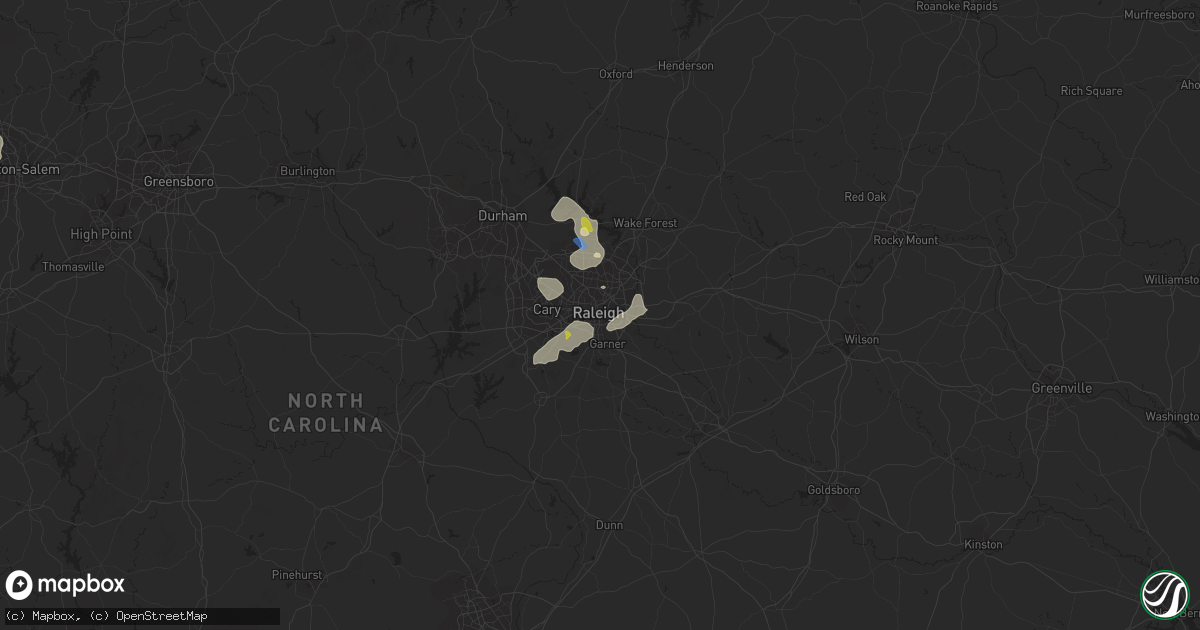
Hail Map in Raleigh, NC on August 14, 2021
Get this storm
August 14 map
$229
one time, instant access
Download today. No call, no setup
Keep the $229
Bought the map and want the full workflow? Apply the entire $229 to a subscription within 7 days. None of it is wasted.
Every map, not just this one
This buys you this map. Subscription and you get every map we run, in the markets you choose from a few cities to whole states to nationwide. Plus real-time alerts the moment a storm fires.
Contact data
Name, contact info, occupancy, even credit band for addresses in the footprint. You go from where it hit to who to call.
Become the source they trust
Unlimited branding weather history reports on demand. You already have the documented answer ready for the property owner, and you are the one who showed up with it.
Property data and RoofTrace estimates
Pull up any address you have got, its value and the exact code rules for that jurisdiction, straight from One Click Code. Then RoofTrace estimates the squares, pitch, and roof value, priced the way you price.
Storm reports in Raleigh, NC
Raleigh, NC
| Date | Description |
|---|---|
| 08/14/20212:10 PM CDT | Large tree down on pembridge lane in raleigh. Time approximated by radar. |
| 08/14/20212:10 PM CDT | A tree was reported down near the intersection of norwood rd and mt. Vernon church rd. Time estimated by radar. |
| 08/14/20212:09 PM CDT | A tree was reported down near the intersection of n falls dr and creedmoor rd. Time estimated by radar. |
| 08/14/20212:08 PM CDT | A tree was reported down near the intersection of fall line ct and old creedmoor rd. Time estimated by radar. |
All States Impacted by Hail Map on August 14, 2021
All Cities Impacted by Hail Map on August 14, 2021
- Arcadia, NE
- Minden, NE
- Fredonia, ND
- Lehr, ND
- Middlesboro, KY
- Chadron, NE
- Wall, SD
- Hermosa, SD
- Waxhaw, NC
- Owanka, SD
- Rapid City, SD
- Juniata, NE
- Wood River, NE
- Hastings, NE
- Wasta, SD
- Nacogdoches, TX
- Cheyenne, WY
- Marion, NC
- Union Mills, NC
- Sedgwick, CO
- Oshkosh, NE
- Keystone, SD
- Hillsdale, WY
- Nunn, CO
- Bogue, KS
- Palco, KS
- Eagle Butte, SD
- Elm Creek, NE
- Charles City, VA
- Petersburg, VA
- Bridgeport, NE
- Ashley, ND
- Ellerbe, NC
- Elsie, NE
- Madrid, NE
- Hayes Center, NE
- Hildreth, NE
- Ellis, KS
- Brownell, KS
- Ogallah, KS
- Wakeeney, KS
- Hill City, KS
- Fort Pierre, SD
- Cary, NC
- Morrisville, NC
- Oelrichs, SD
- Bayard, NE
- Hemingford, NE
- Alliance, NE
- Keysville, VA
- Statesville, NC
- Olin, NC
- Harmony, NC
- Ogallala, NE
- Milesville, SD
- New Underwood, SD
- Philip, SD
- Paxton, NE
- Wallace, NE
- Frederick, SD
- Leola, SD
- Mud Butte, SD
- Grand Island, NE
- Monticello, GA
- Burwell, NE
- Gary, TX
- Timpson, TX
- Ansley, NE
- Buckingham, VA
- Charlotte, NC
- Fort Mill, SC
- Pineville, NC
- Williamsburg, VA
- Alton, VA
- South Boston, VA
- Miller, NE
- Amherst, NE
- Bassett, NE
- Haddock, GA
- Lake Village, AR
- Dermott, AR
- Dillwyn, VA
- White River, SD
- Emporia, VA
- Charlottesville, VA
- Afton, VA
- North Garden, VA
- Crozet, VA
- Greenwood, VA
- Pendleton, SC
- Naytahwaush, MN
- Waubun, MN
- Merriman, NE
- Meherrin, VA
- Norton, TX
- Ballinger, TX
- Sterling, CO
- Merino, CO
- Russellville, KY
- Bucksport, ME
- Chapman, NE
- Bangs, TX
- Ivor, VA
- Smithfield, VA
- Windsor, VA
- Scottsville, KY
- Max Meadows, VA
- Colorado City, AZ
- Union Center, SD
- Browns Summit, NC
- Hot Springs, SD
- Oral, SD
- Whitney, NE
- Chappell, NE
- Ovid, CO
- Phillipsburg, KS
- Scenic, SD
- Kenesaw, NE
- Hay Springs, NE
- Hawley, MN
- Lenoir, NC
- Granite Falls, NC
- Hudson, NC
- Morganton, NC
- Youngstown, FL
- Orleans, NE
- Central, UT
- Newberry, SC
- Pomaria, SC
- Whitmire, SC
- Raleigh, NC
- Jamestown, KY
- Quinlan, TX
- Panama City Beach, FL
- Ebro, FL
- Oak Grove, LA
- Pine Valley, UT
- Mooresburg, TN
- Rogersville, TN
- Poquoson, VA
- Hampton, VA
- Leslie, GA
- Americus, GA
- Onset, MA
- Buzzards Bay, MA
- East Wareham, MA
- Carpenter, WY
- Akron, CO
- Atwood, CO
- Gackle, ND
- Fairburn, SD
- Buffalo Gap, SD
- Holdrege, NE
- Padroni, CO
- Ville Platte, LA
- Gloucester, VA
- Hayes, VA
- Spring Hope, NC
- Middlesex, NC
- Overton, NE
- York, SC
- Rock Hill, SC
- Rice, VA
- Farmville, VA
- Green Bay, VA
- Ivanhoe, VA
- Fries, VA
- Auburn, KY
- Knightdale, NC
- Hays, KS
- Bronte, TX
- Saint George, UT
- Washington, UT
- Drakes Branch, VA
- Saxe, VA
- Monroe, NC
- Long Branch, TX
- Carthage, TX
- Aberdeen, SD
- White Plains, MD
- La Plata, MD
- Pomfret, MD
- Belton, KY
- Durham, NC
- Ponce De Leon, FL
- Vernon, FL
- Bowling Green, KY
- Bingham, NE
- Gordon, NE
- Winston Salem, NC
- Peachland, NC
- Loomis, NE
- Sutherland, NE
- Saint Libory, NE
- Nebo, NC
- Wendell, NC
- Richmond, VA
- Fletcher, NC
- Fairview, NC
- Asheville, NC
- Greenwood, SC
- Prince George, VA
- Hopewell, VA
- Prairie View, KS
- Long Island, KS
- Hermitage, AR
- Norwood, GA
- Warrenton, GA
- Sparta, GA
- Stamford, NE
- Sedley, VA
- Courtland, VA
- May, TX
- North Loup, NE
- Lincolnton, NC
- Box Elder, SD
- Heartwell, NE
- Wakefield, VA
- Dalton, NE
- McCracken, KS
- Caputa, SD
- Burkeville, VA
- Wilcox, NE
- Capron, VA
- Victoria, VA
- Elberon, VA
- Burns, WY
- Abbeville, SC
- Calhoun Falls, SC
- Iva, SC
- Milton, FL
- Spring Grove, VA
- Almena, KS
- Marshville, NC
- Rockfield, KY
- Crewe, VA
- Piedmont, SC
- Gray Court, SC
- Enoree, SC
- Walland, TN
- Fort Worth, TX
- Huntington, TX
- Waldorf, MD
- Crawford, NE
- Tenaha, TX
- Grover, CO
- Bristol, FL
- Enterprise, UT
- Eaton, CO
- Greeley, CO
- Gill, CO
- Ault, CO
- Litchfield, NE
- Mason City, NE
- Marsland, NE
- Ashton, NE
- Trumbull, NE
- Disputanta, VA
- Carson, VA
- Fort Eustis, VA
- Newport News, VA
- Cherry Creek, SD
- Union, SC
- Angora, NE
- Eagle Springs, NC
- Albany, GA
- Leesburg, GA
- McKenney, VA
- Zebulon, NC
- Sanford, NC
- Freeport, FL
- Barnesville, MN
- Winters, TX
- Virginia Beach, VA
- Candor, NC
- Tellico Plains, TN
- Washington, GA
- Crawfordville, GA
- Panama City, FL
- Reidsville, NC
- Wewahitchka, FL
- Howes, SD
- Monticello, AR
- Polkton, NC
- Logan, KS
- Franklin, VA
- Zuni, VA
- Chester, SC
- Graham, NC
- Mebane, NC
- Haw River, NC
- Ruther Glen, VA
- Center, TX
- Ord, NE
- Plum Branch, SC
- Pageland, SC
- Streeter, ND
- Stockton Springs, ME
- Frankfort, ME
- Smithville, GA
- Amelia, NE
- Athens, TX
- El Dorado, AR
- Norfolk, VA
- Providence Forge, VA
- Waverly, VA
- Yale, VA
- Sidney, NE
- Apex, NC
- Holly Springs, NC
- Elba, NE
- Chappell, KY
- Bledsoe, KY
- Baxter, KY
- Chase City, VA
- Williamston, SC
- Easley, SC
- Pelzer, SC
- Oxford, NE
- Santa Anna, TX
- Brownwood, TX
- Draper, VA
- Pamplin, VA
- Waxahachie, TX
- State Road, NC
- Duffield, VA
- Dallas, TX
- Dobson, NC
- Sheridan, AR
- Oakland, KY
- Smiths Grove, KY
- Cleveland, SC
- Upland, NE
- Blair, SC
- Branchville, VA
- Maryville, TN
- Rockford, TN
- Carthage, NC
- Hampden Sydney, VA
- Jay, FL
- Laurens, SC
- Sumner, NE
- Surry, VA
- Dendron, VA
- Campti, LA
- Yorktown, VA
- Scottsville, VA
- Ellsworth, NE
- Wake Forest, NC
- Trinity, TX
- Henrico, VA
- Matthews, NC
- Indian Trail, NC
- Randolph, VA
- Knoxville, TN
- Keystone, NE
- Grant, NE
- Suffolk, VA


