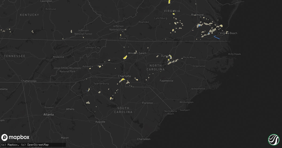
Hail Map in North Carolina on August 14, 2021
Get this storm
August 14 map
$229
one time, instant access
Download today. No call, no setup
Keep the $229
Bought the map and want the full workflow? Apply the entire $229 to a subscription within 7 days. None of it is wasted.
Every map, not just this one
This buys you this map. Subscription and you get every map we run, in the markets you choose from a few cities to whole states to nationwide. Plus real-time alerts the moment a storm fires.
Contact data
Name, contact info, occupancy, even credit band for addresses in the footprint. You go from where it hit to who to call.
Become the source they trust
Unlimited branding weather history reports on demand. You already have the documented answer ready for the property owner, and you are the one who showed up with it.
Property data and RoofTrace estimates
Pull up any address you have got, its value and the exact code rules for that jurisdiction, straight from One Click Code. Then RoofTrace estimates the squares, pitch, and roof value, priced the way you price.
Storm reports in North Carolina
North Carolina
| Date | Description |
|---|---|
| 08/14/20214:17 PM CDT | Tree down at bentley ct. And westhaven cir. |
| 08/14/20214:15 PM CDT | A couple of trees down on country club rd. Between queensbury rd. And ryandale rd. |
| 08/14/20214:13 PM CDT | Tree down at knob view dr. And mountain view rd nw. |
| 08/14/20214:05 PM CDT | Emergency mngr reported trees down on old us hwy 221 |
| 08/14/20214:00 PM CDT | Emergency mngr reported trees down on sugar hill rd. |
| 08/14/20214:00 PM CDT | Fire dept reported trees down on lentz rd |
| 08/14/20214:00 PM CDT | Emergency mngr reported a barn was destroyed and trees down. |
| 08/14/20213:56 PM CDT | Tree down and across shore rd.... Near beaver dam ln. |
| 08/14/20213:50 PM CDT | 911 call center reported trees and power lines down on clarks chapel rd. |
| 08/14/20213:45 PM CDT | Numerous trees down in the harmony and turnersburg area. Fire department crew spent hours cutting up trees to get them out of the roadway. |
| 08/14/20213:45 PM CDT | Fire dept reported rv flipped over on i77 at tomlin mill rd. |
| 08/14/20213:45 PM CDT | Trees and power lines down on on calico rd. |
| 08/14/20213:40 PM CDT | Fire dept reported powerlines down on tomlin mill rd. |
| 08/14/20213:35 PM CDT | Emergency mngr reported power lines down |
| 08/14/20213:35 PM CDT | Emergency mngr reported trees down on fairmount rd |
| 08/14/20213:35 PM CDT | Broadcast media reported multiple trees and powerlines down along frank whisnant rd. |
| 08/14/20213:30 PM CDT | Some trees and numerous tree limbs down across the fire department district. |
| 08/14/20213:25 PM CDT | Emergency mngr reported trees down on tabor rd. |
| 08/14/20213:25 PM CDT | Emergency mngr reported trees down on powell bridge rd |
| 08/14/20213:25 PM CDT | Emergency mngr reported trees down on stack rd |
| 08/14/20213:15 PM CDT | Trees down near cuthbertson rd & s providence rd. |
| 08/14/20212:48 PM CDT | Public reports up to quarter sized hail at the raleigh durham international airport. Time estimated by radar. |
| 08/14/20212:36 PM CDT | A large tree was reported down near the intersection of avent ferry rd and center hill dr. The road is closed between center hill dr and new hill holleman rd. Time esti |
| 08/14/20212:10 PM CDT | A tree was reported down near the intersection of norwood rd and mt. Vernon church rd. Time estimated by radar. |
| 08/14/20212:10 PM CDT | Large tree down on pembridge lane in raleigh. Time approximated by radar. |
| 08/14/20212:09 PM CDT | A tree was reported down near the intersection of n falls dr and creedmoor rd. Time estimated by radar. |
| 08/14/20212:08 PM CDT | A tree was reported down near the intersection of fall line ct and old creedmoor rd. Time estimated by radar. |
| 08/14/20212:00 PM CDT | Trees and power lines down on sharon road west. |
| 08/14/20211:59 PM CDT | Public reported large trees down and a demolished shed on eva ct |
| 08/14/20211:35 PM CDT | A tree was reported down at highway 64 west near zebulon. Time estimated by radar. |
| 08/14/20217:37 AM CDT | At 1236 AM EDT, severe thunderstorms were located along a line extending from near Spencer to High Rock Lake to near Mt Pleasant, moving northeast at 10 mph. HAZARD...60 mph wind gusts and quarter size hail. SOURCE...Radar indicated. IMPACT...Hail damage to vehicles is expected. Expect wind damage to roofs, siding, and trees. Locations impacted include... Lexington, Albemarle, Badin Lake, Thomasville, Linwood, Plyler, Badin, Denton, Richfield and New London. |
| 08/14/20217:33 AM CDT | At 1232 AM EDT, a severe thunderstorm was located 6 miles east of Downtown Concord, or near Mt Pleasant, moving east at 20 mph. HAZARD...60 mph wind gusts and quarter size hail. SOURCE...Radar indicated. IMPACT...Minor hail damage to vehicles is expected. Expect wind damage to trees and power lines. Locations impacted include... Rockwell, Mt Pleasant, High Rock Lake, Gold Hill, Finger, Faith, Granite Quarry, Downtown Concord and Kannapolis. |
| 08/14/202112:19 AM CDT | At 518 PM EDT, a severe thunderstorm was located 7 miles southeast of Graham, moving north at 10 mph. HAZARD...60 mph wind gusts and penny size hail. SOURCE...Radar indicated. IMPACT...Expect damage to roofs, siding, and trees. Locations impacted include... Burlington, Graham, Mebane, Elon, Gibsonville, Haw River, Swepsonville, Alamance, Snow Camp and Lake Burlington. |
| 08/13/202111:55 PM CDT | At 455 PM EDT, a severe thunderstorm was located 5 miles southwest of Marion, and is nearly stationary. HAZARD...60 mph wind gusts and quarter size hail. SOURCE...Radar indicated. IMPACT...Minor hail damage to vehicles is expected. Expect wind damage to trees and power lines. Locations impacted include... Marion, Old Fort, Lake James State Park, Lake James, Nebo, Sugar Hill, Thermal City, Pleasant Gardens, Glenwood and Fero. |
| 08/13/202111:50 PM CDT | At 450 PM EDT, a severe thunderstorm was located near Winston-Salem, and is nearly stationary. HAZARD...60 mph wind gusts and quarter size hail. SOURCE...Radar indicated. IMPACT...Hail damage to vehicles is expected. Expect wind damage to roofs, siding, and trees. Locations impacted include... Winston-Salem, Kernersville, Clemmons, Lewisville, Walkertown, Rural Hall, Pfafftown, Stanleyville, Sedge Garden and Donnaha. |
| 08/13/202111:35 PM CDT | At 435 PM EDT, a severe thunderstorm was located 12 miles northwest of Rutherfordton, or 5 miles northeast of Lake Lure, and is nearly stationary. HAZARD...60 mph wind gusts and quarter size hail. SOURCE...Radar indicated. IMPACT...Minor hail damage to vehicles is expected. Expect wind damage to trees and power lines. Locations impacted include... Lake Lure, Chimney Rock Village, Chimney Rock State Park, Shingle Hollow, Green Hill, Sugar Hill, Thermal City, Fero, Union Mills and Rutherfordton. |
| 08/13/202111:34 PM CDT | At 434 PM EDT, a severe thunderstorm was located 7 miles southeast of Marion, and is nearly stationary. HAZARD...60 mph wind gusts and quarter size hail. SOURCE...Radar indicated. IMPACT...Minor hail damage to vehicles is expected. Expect wind damage to trees and power lines. Locations impacted include... Thermal City, Glenwood, Sunshine, Fero, Dysartsville, Union Mills and South Mountains State Park. |
| 08/13/202111:33 PM CDT | At 433 PM EDT, a severe thunderstorm was located 8 miles northeast of Statesville, or 5 miles southwest of Harmony, and is nearly stationary. HAZARD...60 mph wind gusts and quarter size hail. SOURCE...Radar indicated. IMPACT...Minor hail damage to vehicles is expected. Expect wind damage to trees and power lines. Locations impacted include... Statesville, Harmony, Turnersburg, Olin, Sheffield, Woodleaf, Cool Springs, Mocksville and Union Grove. |
| 08/13/202111:25 PM CDT | At 424 PM EDT, a severe thunderstorm was located near Morganton, moving east at 5 mph. HAZARD...60 mph wind gusts and quarter size hail. SOURCE...Radar indicated. IMPACT...Minor hail damage to vehicles is expected. Expect wind damage to trees and power lines. Locations impacted include... Morganton, Sawmills, Valdese, Gamewell, Hudson, Icard, Cajah's Mountain, Drexel, Connelly Springs and Rutherford College. |
| 08/13/202111:22 PM CDT | At 422 PM EDT, a severe thunderstorm was located 9 miles southeast of Downtown Asheville, or near Fairview In Buncombe County, moving south at 10 mph. HAZARD...60 mph wind gusts and quarter size hail. SOURCE...Radar indicated. IMPACT...Minor hail damage to vehicles is expected. Expect wind damage to trees and power lines. Locations impacted include... East Asheville, Arden, Black Mountain, Mills River, Fletcher, Swannanoa, Fairview In Buncombe County, Mountain Home, Biltmore Forest and Bat Cave. |
| 08/13/202111:00 PM CDT | At 400 PM EDT, a severe thunderstorm was located 8 miles south of Yadkinville, or 4 miles south of Lone Hickory, and is nearly stationary. HAZARD...60 mph wind gusts and quarter size hail. SOURCE...Radar indicated. IMPACT...Minor hail damage to vehicles is expected. Expect wind damage to trees and power lines. Locations impacted include... Mocksville, Bermuda Run, Cooleemee, Harmony, Turnersburg, Olin, Sheffield, Farmington, Woodleaf and Cool Springs. |
| 08/13/202110:53 PM CDT | At 353 PM EDT, a severe thunderstorm was located near Creedmoor, moving north at 15 mph. HAZARD...60 mph wind gusts. SOURCE...Radar indicated. IMPACT...Expect damage to roofs, siding, and trees. Locations impacted include... Durham, Creedmoor, Butner, Stem, Falls Lake, Lake Michie, Lake Butner, Falls Lake State Rec Area, Falls Lake Boat Ramp and Purnell. |
| 08/13/202110:39 PM CDT | At 339 PM EDT, a severe thunderstorm was located over RDU International, or near Cary, and is nearly stationary. HAZARD...60 mph wind gusts and quarter size hail. SOURCE...Radar indicated. IMPACT...Hail damage to vehicles is expected. Expect wind damage to roofs, siding, and trees. Locations impacted include... Raleigh, Durham, Cary, RDU International, Morrisville, Research Triangle, William B Umstead State Park, Parkwood, Bethesda and Carpenter. |
| 08/13/202110:27 PM CDT | At 327 PM EDT, a severe thunderstorm was located near Fuquay-Varina, or 8 miles south of Cary, moving southwest at 10 mph. HAZARD...60 mph wind gusts and nickel size hail. SOURCE...Radar indicated. IMPACT...Expect damage to roofs, siding, and trees. Locations impacted include... Cary, Fuquay-Varina, Apex, Holly Springs, New Hill, Lake Wheeler, Harris Lake Boat Launch, Shearon Harris Reservoir and Duncan. |
| 08/13/202110:17 PM CDT | At 316 PM EDT, a severe thunderstorm was located over Carowinds, or 8 miles northwest of Indian Land, moving west at 20 mph. HAZARD...60 mph wind gusts. SOURCE...Radar indicated. IMPACT...Expect damage to roofs, siding, and trees. Locations impacted include... Indian Land and Community of Almond Glen. |
| 08/13/202110:15 PM CDT | At 315 PM EDT, a severe thunderstorm was located 11 miles northeast of Pickens, or 4 miles east of Table Rock State Park, moving south at 10 mph. HAZARD...60 mph wind gusts and quarter size hail. SOURCE...Radar indicated. IMPACT...Minor hail damage to vehicles is expected. Expect wind damage to trees and power lines. Locations impacted include... Pickens, Berea, Slater-Marietta, Table Rock State Park, Jones Gap State Park, Caesars Head State Park, Pumpkintown, Dacusville and Cleveland. |
| 08/13/202110:01 PM CDT | At 301 PM EDT, a severe thunderstorm was located 7 miles northeast of RDU International, or 7 miles north of Raleigh, moving north at 10 mph. HAZARD...60 mph wind gusts and quarter size hail. SOURCE...Radar indicated. IMPACT...Hail damage to vehicles is expected. Expect wind damage to roofs, siding, and trees. Locations impacted include... Raleigh, Durham, Cary, Wake Forest, RDU International, Morrisville, Falls Lake State Rec Area, Gorman, William B Umstead State Park and Research Triangle. |
| 08/13/20219:53 PM CDT | At 253 PM EDT, a severe thunderstorm was located near Lincolnton, moving north at 10 mph. HAZARD...60 mph wind gusts and quarter size hail. SOURCE...Radar indicated. IMPACT...Minor hail damage to vehicles is expected. Expect wind damage to trees and power lines. Locations impacted include... Newton, Lincolnton, St. Stephens, Conover, Maiden, Claremont, Boger City, Iron Station, Sherrills Ford and Bandys. |
| 08/13/20219:52 PM CDT | At 251 PM EDT, a severe thunderstorm was located over State Road, or near Mountain Park, moving southeast at 10 mph. HAZARD...60 mph wind gusts and half dollar size hail. SOURCE...Radar indicated. IMPACT...Hail damage to vehicles is expected. Expect wind damage to roofs, siding, and trees. Locations impacted include... Elkin... Fairview... Dobson... Mountain Park... State Road... Benham... and Burch. |
| 08/13/20219:50 PM CDT | At 250 PM EDT, a severe thunderstorm was located near Garner, or near Raleigh, moving southwest at 10 mph. HAZARD...60 mph wind gusts and quarter size hail. SOURCE...Radar indicated. IMPACT...Hail damage to vehicles is expected. Expect wind damage to roofs, siding, and trees. Locations impacted include... Raleigh, Cary, Garner, Fuquay-Varina, Apex, Holly Springs, Morrisville, New Hill, Lake Wheeler and William B Umstead State Park. |
| 08/13/20219:43 PM CDT | At 243 PM EDT, a severe thunderstorm was located 13 miles northeast of Monroe, or 7 miles north of Marshville, and is nearly stationary. HAZARD...60 mph wind gusts and quarter size hail. SOURCE...Radar indicated. IMPACT...Minor hail damage to vehicles is expected. Expect wind damage to trees and power lines. Locations impacted include... Monroe, Unionville, Wingate, Marshville, New Salem and Fairview In Union County. |
| 08/13/20219:15 PM CDT | At 215 PM EDT, a severe thunderstorm was located 8 miles west of Zebulon, or 10 miles east of Raleigh, moving east at 5 mph. HAZARD...60 mph wind gusts and quarter size hail. SOURCE...Radar indicated. IMPACT...Hail damage to vehicles is expected. Expect wind damage to roofs, siding, and trees. Locations impacted include... Raleigh, Wake Forest, Garner, Clayton, Zebulon, Bunn, Knightdale, Wendell, Rolesville and Middlesex. |
| 08/13/20219:09 PM CDT | At 209 PM EDT, a severe thunderstorm was located 7 miles west of Ansonville, or 12 miles northwest of Wadesboro, moving northeast at 5 mph. HAZARD...60 mph wind gusts and quarter size hail. SOURCE...Radar indicated. IMPACT...Hail damage to vehicles is expected. Expect wind damage to roofs, siding, and trees. Locations impacted include... Ansonville, Polkton, Norwood and Lake Tillery. |
All States Impacted by Hail Map on August 14, 2021
Cities Impacted by Hail Map on August 14, 2021
- Arcadia, NE
- Minden, NE
- Fredonia, ND
- Lehr, ND
- Middlesboro, KY
- Chadron, NE
- Wall, SD
- Hermosa, SD
- Waxhaw, NC
- Owanka, SD
- Rapid City, SD
- Juniata, NE
- Wood River, NE
- Hastings, NE
- Wasta, SD
- Nacogdoches, TX
- Cheyenne, WY
- Marion, NC
- Union Mills, NC
- Sedgwick, CO
- Oshkosh, NE
- Keystone, SD
- Hillsdale, WY
- Nunn, CO
- Bogue, KS
- Palco, KS
- Eagle Butte, SD
- Elm Creek, NE
- Charles City, VA
- Petersburg, VA
- Bridgeport, NE
- Ashley, ND
- Ellerbe, NC
- Elsie, NE
- Madrid, NE
- Hayes Center, NE
- Hildreth, NE
- Ellis, KS
- Brownell, KS
- Ogallah, KS
- Wakeeney, KS
- Hill City, KS
- Fort Pierre, SD
- Cary, NC
- Morrisville, NC
- Oelrichs, SD
- Bayard, NE
- Hemingford, NE
- Alliance, NE
- Keysville, VA
- Statesville, NC
- Olin, NC
- Harmony, NC
- Ogallala, NE
- Milesville, SD
- New Underwood, SD
- Philip, SD
- Paxton, NE
- Wallace, NE
- Frederick, SD
- Leola, SD
- Mud Butte, SD
- Grand Island, NE
- Monticello, GA
- Burwell, NE
- Gary, TX
- Timpson, TX
- Ansley, NE
- Buckingham, VA
- Charlotte, NC
- Fort Mill, SC
- Pineville, NC
- Williamsburg, VA
- Alton, VA
- South Boston, VA
- Miller, NE
- Amherst, NE
- Bassett, NE
- Haddock, GA
- Lake Village, AR
- Dermott, AR
- Dillwyn, VA
- White River, SD
- Emporia, VA
- Charlottesville, VA
- Afton, VA
- North Garden, VA
- Crozet, VA
- Greenwood, VA
- Pendleton, SC
- Naytahwaush, MN
- Waubun, MN
- Merriman, NE
- Meherrin, VA
- Norton, TX
- Ballinger, TX
- Sterling, CO
- Merino, CO
- Russellville, KY
- Bucksport, ME
- Chapman, NE
- Bangs, TX
- Ivor, VA
- Smithfield, VA
- Windsor, VA
- Scottsville, KY
- Max Meadows, VA
- Colorado City, AZ
- Union Center, SD
- Browns Summit, NC
- Hot Springs, SD
- Oral, SD
- Whitney, NE
- Chappell, NE
- Ovid, CO
- Phillipsburg, KS
- Scenic, SD
- Kenesaw, NE
- Hay Springs, NE
- Hawley, MN
- Lenoir, NC
- Granite Falls, NC
- Hudson, NC
- Morganton, NC
- Youngstown, FL
- Orleans, NE
- Central, UT
- Newberry, SC
- Pomaria, SC
- Whitmire, SC
- Raleigh, NC
- Jamestown, KY
- Quinlan, TX
- Panama City Beach, FL
- Ebro, FL
- Oak Grove, LA
- Pine Valley, UT
- Mooresburg, TN
- Rogersville, TN
- Poquoson, VA
- Hampton, VA
- Leslie, GA
- Americus, GA
- Onset, MA
- Buzzards Bay, MA
- East Wareham, MA
- Carpenter, WY
- Akron, CO
- Atwood, CO
- Gackle, ND
- Fairburn, SD
- Buffalo Gap, SD
- Holdrege, NE
- Padroni, CO
- Ville Platte, LA
- Gloucester, VA
- Hayes, VA
- Spring Hope, NC
- Middlesex, NC
- Overton, NE
- York, SC
- Rock Hill, SC
- Rice, VA
- Farmville, VA
- Green Bay, VA
- Ivanhoe, VA
- Fries, VA
- Auburn, KY
- Knightdale, NC
- Hays, KS
- Bronte, TX
- Saint George, UT
- Washington, UT
- Drakes Branch, VA
- Saxe, VA
- Monroe, NC
- Long Branch, TX
- Carthage, TX
- Aberdeen, SD
- White Plains, MD
- La Plata, MD
- Pomfret, MD
- Belton, KY
- Durham, NC
- Ponce De Leon, FL
- Vernon, FL
- Bowling Green, KY
- Bingham, NE
- Gordon, NE
- Winston Salem, NC
- Peachland, NC
- Loomis, NE
- Sutherland, NE
- Saint Libory, NE
- Nebo, NC
- Wendell, NC
- Richmond, VA
- Fletcher, NC
- Fairview, NC
- Asheville, NC
- Greenwood, SC
- Prince George, VA
- Hopewell, VA
- Prairie View, KS
- Long Island, KS
- Hermitage, AR
- Norwood, GA
- Warrenton, GA
- Sparta, GA
- Stamford, NE
- Sedley, VA
- Courtland, VA
- May, TX
- North Loup, NE
- Lincolnton, NC
- Box Elder, SD
- Heartwell, NE
- Wakefield, VA
- Dalton, NE
- McCracken, KS
- Caputa, SD
- Burkeville, VA
- Wilcox, NE
- Capron, VA
- Victoria, VA
- Elberon, VA
- Burns, WY
- Abbeville, SC
- Calhoun Falls, SC
- Iva, SC
- Milton, FL
- Spring Grove, VA
- Almena, KS
- Marshville, NC
- Rockfield, KY
- Crewe, VA
- Piedmont, SC
- Gray Court, SC
- Enoree, SC
- Walland, TN
- Fort Worth, TX
- Huntington, TX
- Waldorf, MD
- Crawford, NE
- Tenaha, TX
- Grover, CO
- Bristol, FL
- Enterprise, UT
- Eaton, CO
- Greeley, CO
- Gill, CO
- Ault, CO
- Litchfield, NE
- Mason City, NE
- Marsland, NE
- Ashton, NE
- Trumbull, NE
- Disputanta, VA
- Carson, VA
- Fort Eustis, VA
- Newport News, VA
- Cherry Creek, SD
- Union, SC
- Angora, NE
- Eagle Springs, NC
- Albany, GA
- Leesburg, GA
- McKenney, VA
- Zebulon, NC
- Sanford, NC
- Freeport, FL
- Barnesville, MN
- Winters, TX
- Virginia Beach, VA
- Candor, NC
- Tellico Plains, TN
- Washington, GA
- Crawfordville, GA
- Panama City, FL
- Reidsville, NC
- Wewahitchka, FL
- Howes, SD
- Monticello, AR
- Polkton, NC
- Logan, KS
- Franklin, VA
- Zuni, VA
- Chester, SC
- Graham, NC
- Mebane, NC
- Haw River, NC
- Ruther Glen, VA
- Center, TX
- Ord, NE
- Plum Branch, SC
- Pageland, SC
- Streeter, ND
- Stockton Springs, ME
- Frankfort, ME
- Smithville, GA
- Amelia, NE
- Athens, TX
- El Dorado, AR
- Norfolk, VA
- Providence Forge, VA
- Waverly, VA
- Yale, VA
- Sidney, NE
- Apex, NC
- Holly Springs, NC
- Elba, NE
- Chappell, KY
- Bledsoe, KY
- Baxter, KY
- Chase City, VA
- Williamston, SC
- Easley, SC
- Pelzer, SC
- Oxford, NE
- Santa Anna, TX
- Brownwood, TX
- Draper, VA
- Pamplin, VA
- Waxahachie, TX
- State Road, NC
- Duffield, VA
- Dallas, TX
- Dobson, NC
- Sheridan, AR
- Oakland, KY
- Smiths Grove, KY
- Cleveland, SC
- Upland, NE
- Blair, SC
- Branchville, VA
- Maryville, TN
- Rockford, TN
- Carthage, NC
- Hampden Sydney, VA
- Jay, FL
- Laurens, SC
- Sumner, NE
- Surry, VA
- Dendron, VA
- Campti, LA
- Yorktown, VA
- Scottsville, VA
- Ellsworth, NE
- Wake Forest, NC
- Trinity, TX
- Henrico, VA
- Matthews, NC
- Indian Trail, NC
- Randolph, VA
- Knoxville, TN
- Keystone, NE
- Grant, NE
- Suffolk, VA


