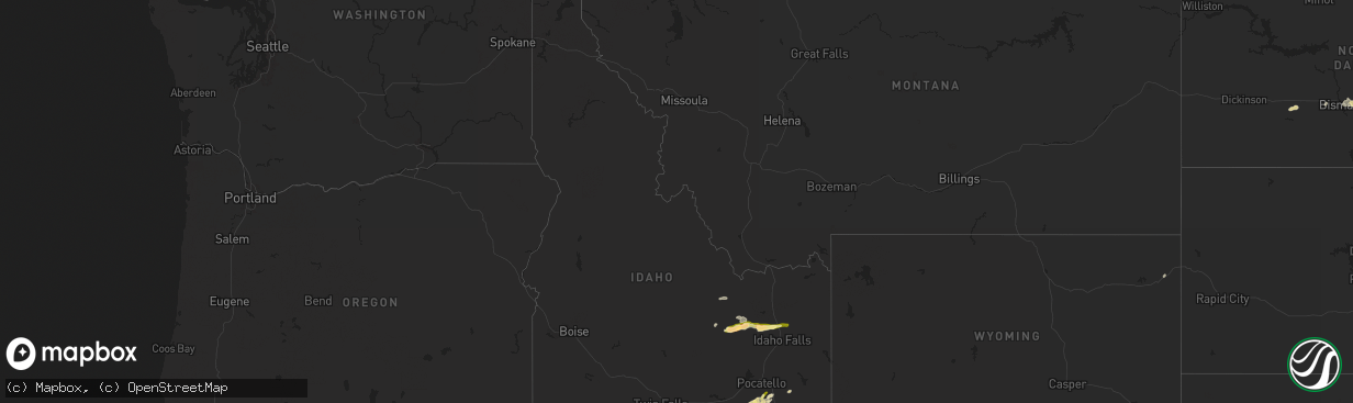
Hail Map in Idaho on August 13, 2024
The weather event in Idaho on August 13, 2024 includes Hail and Wind maps. 14 states and 262 cities were impacted and suffered possible damage. The total estimated number of properties impacted is 1,623.
Want more than just the map?
Turn this storm into a full workflow.
- Owner + property data so you know who to knock
- OnDemand branded weather history reports to win the "did we even have hail?" argument
- RoofTrace estimate so reps stop guessing numbers at the door
Bought this map? Upgrade within 7 days and we'll credit the $230. (10-15 min setup call)
Hail
Wind
1,623
Estimated number of impacted properties by a 1.00" hail or larger56
Estimated number of impacted properties by a 1.75" hail or larger0
Estimated number of impacted properties by a 2.50" hail or largerStorm reports in Idaho
Idaho
| Date | Description |
|---|---|
| 08/13/20246:10 PM CDT | Sheep creek hills id pacficorp mesonet. |
| 08/13/20244:42 PM CDT | A local report indicates 1.00 inch wind near 3 WNW Lewisville |
| 08/13/20244:41 PM CDT | Rocky mountain power reports power outage in the area due to thunderstorm winds. |
| 08/13/20244:35 PM CDT | Large tree limb snapped off. Time estimated based on radar. |
| 08/13/20243:00 PM CDT | Measured at the scout mountain campground. Hail was ongoing at the time of the report. |
| 08/13/20242:58 PM CDT | Multiple reports via social media of quarter size hail at idaho national laboratory. Report of significant ground accumulation. Time estimated based on radar. |
| 08/13/20242:45 PM CDT | Delayed report passed along from butte county em of crop damage from hail of unknown size. Time estimated. |
| 08/13/202411:15 AM CDT | A local report indicates 59 MPH wind near 14 SSE Malta |
All States Impacted by Hail Map on August 13, 2024
Cities Impacted by Hail Map on August 13, 2024
- Oswego, KS
- Malta, ID
- Bancroft, ID
- Bamberg, SC
- Moore, ID
- Rockland, ID
- Arimo, ID
- Aguilar, CO
- Ruffin, SC
- Arbon, ID
- Pocatello, ID
- Howe, ID
- Mccammon, ID
- Terreton, ID
- Glen Ullin, ND
- Trinidad, CO
- Harrisburg, NE
- Holbrook, ID
- Wendover, UT
- Randolph, UT
- Malad City, ID
- Cokeville, WY
- Pueblo, CO
- Gulfport, MS
- Long Beach, MS
- Mandan, ND
- Payson, AZ
- Franktown, CO
- Avondale, CO
- Roberts, ID
- Port Allen, LA
- Loveland, CO
- Parker, CO
- Kimball, NE
- Kanab, UT
- Menan, ID
- Lewisville, ID
- Rigby, ID
- Dugway, UT
- Elizabeth, CO
- Kiowa, CO
- Kemmerer, WY
- Hanksville, UT
- Bridgeport, NE
- Bayard, NE
- Antimony, UT
- Lamar, CO
- Ault, CO
- Bennett, CO
- Grover, CO
- Keenesburg, CO
- Bismarck, ND
- La Junta, CO
- Kersey, CO
- Briggsdale, CO
- La Salle, CO
- Deer Trail, CO
- Dalton, NE
- Menoken, ND
- Clifton, ID
- Holly, CO
- Las Animas, CO
- Byers, CO
- Broadwater, NE
- Grantsville, UT
- Rush Valley, UT
- Stockton, UT
- Roggen, CO
- Dayton, ID
- Bushnell, NE
- Tribune, KS
- Tooele, UT
- Clearfield, UT
- Sheridan Lake, CO
- Sterling, ND
- Agate, CO
- Winslow, AZ
- Hill Afb, UT
- Magna, UT
- Layton, UT
- Ogden, UT
- Centerville, UT
- Kaysville, UT
- Farmington, UT
- Strasburg, CO
- Fort Morgan, CO
- Stoneham, CO
- Weskan, KS
- Cornish, UT
- Clarkston, UT
- Dix, NE
- Herriman, UT
- Driscoll, ND
- Oshkosh, NE
- Lisco, NE
- Eagle Mountain, UT
- Akron, CO
- Woodrow, CO
- Saratoga Springs, UT
- Cedar Valley, UT
- Trenton, UT
- Brush, CO
- Lehi, UT
- Vineyard, UT
- Orem, UT
- American Fork, UT
- Lindon, UT
- Pleasant Grove, UT
- Riverton, UT
- Draper, UT
- Sundance, WY
- Newton, UT
- Iliff, CO
- Steele, ND
- Dawson, ND
- Gurley, NE
- Sterling, CO
- Limon, CO
- Salt Lake City, UT
- Provo, UT
- Otis, CO
- Lewellen, NE
- Goodland, KS
- Peetz, CO
- Logan, UT
- Alpine, UT
- Merino, CO
- Atwood, CO
- Fleming, CO
- Haxtun, CO
- Yuma, CO
- Cope, CO
- Eckley, CO
- Anton, CO
- Flagler, CO
- Wray, CO
- Paoli, CO
- Amherst, CO
- Holyoke, CO
- Venango, NE
- Vernon, CO
- Idalia, CO
- Joes, CO
- Big Springs, NE
- Grinnell, KS
- Brule, NE
- Hoxie, KS
- Parks, NE
- Haigler, NE
- Palisade, NE
- Culbertson, NE
- Champion, NE
- Oakley, KS
- Imperial, NE
- Wauneta, NE
- Enders, NE
- Benkelman, NE
- Hayes Center, NE
- McCook, NE
- Maywood, NE
- Saint Francis, KS
- Beaver City, NE
- Arapahoe, NE
- Curtis, NE
- Bartley, NE
- Indianola, NE
- Cambridge, NE
- Moorefield, NE
- Max, NE
- Trenton, NE
- Stratton, NE
- Elsie, NE
- Eustis, NE
- Stockville, NE
- Edison, NE
- Lebanon, NE
- Danbury, NE
- Lindon, CO
- New Raymer, CO
- Colorado Springs, CO
- Seibert, CO
- Oxford, NE
- Yoder, CO
- Castle Rock, CO
- Holbrook, NE
- Elwood, NE
- Farnam, NE
- Wallace, NE
- Dickens, NE
- Bertrand, NE
- Smithfield, NE
- Lexington, NE
- Eddyville, NE
- Sumner, NE
- Overton, NE
- Miller, NE
- Ludell, KS
- Atwood, KS
- Wilsonville, NE
- Hendley, NE
- Ravenna, NE
- Hazard, NE
- Pleasanton, NE
- Oberlin, KS
- Mason City, NE
- Grand Island, NE
- Saint Libory, NE
- Herndon, KS
- Loomis, NE
- Grant, NE
- Hampton, NE
- Chapman, NE
- Rockville, NE
- Saint Paul, NE
- Lame Deer, MT
- Marquette, NE
- Central City, NE
- Bradshaw, NE
- Polk, NE
- Archer, NE
- Dannebrog, NE
- Palmer, NE
- Benedict, NE
- Stromsburg, NE
- Arcadia, NE
- Loup City, NE
- Clarks, NE
- Gresham, NE
- Osceola, NE
- Wolbach, NE
- Shelby, NE
- Otter, MT
- Greenwood, NE
- Waverly, NE
- Nebraska City, NE
- Avoca, NE
- Ashland, NE
- Weeping Water, NE
- Hamburg, IA
- Rock Port, MO
- Louisville, NE
- Plattsmouth, NE
- Springfield, NE
- Westboro, MO
- Maryville, MO
- Ravenwood, MO
- Stanberry, MO
- Clyde, MO
- Gretna, NE
- Cedar Creek, NE
- Elkland, MO
- McFall, MO
- Darlington, MO
- Albany, MO
- Coin, IA
- Pattonsburg, MO
- Pickering, MO
- Hopkins, MO
- Stanton, NE
- Wisner, NE
- Pilger, NE
- Breckenridge, MO


