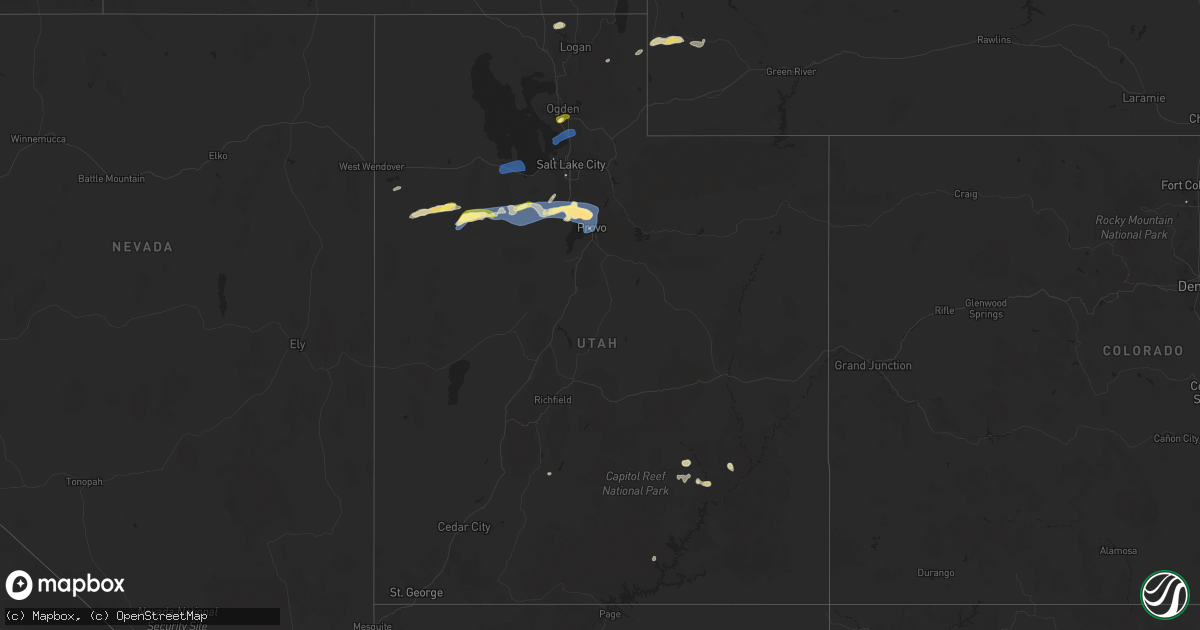
Hail Map in Utah on August 13, 2024
Get this storm
August 13 map
$229
one time, instant access
Download today. No call, no setup
Keep the $229
Bought the map and want the full workflow? Apply the entire $229 to a subscription within 7 days. None of it is wasted.
Every map, not just this one
This buys you this map. Subscription and you get every map we run, in the markets you choose from a few cities to whole states to nationwide. Plus real-time alerts the moment a storm fires.
Contact data
Name, contact info, occupancy, even credit band for addresses in the footprint. You go from where it hit to who to call.
Become the source they trust
Unlimited branding weather history reports on demand. You already have the documented answer ready for the property owner, and you are the one who showed up with it.
Property data and RoofTrace estimates
Pull up any address you have got, its value and the exact code rules for that jurisdiction, straight from One Click Code. Then RoofTrace estimates the squares, pitch, and roof value, priced the way you price.
Storm reports in Utah
Utah
| Date | Description |
|---|---|
| 08/13/20246:55 PM CDT | Measured at a personal weather station in saratoga springs. |
| 08/13/20246:48 PM CDT | Quarter sized hail estimates from a photo received via social media. Time estimated by radar. |
| 08/13/20246:25 PM CDT | A social media post showed pictures of a large tree snapped in half in magna. |
| 08/13/20246:10 PM CDT | Measured at the sr-177 at mp 5 udot rwis site in kaysville. |
| 08/13/20246:10 PM CDT | Photo of hail from social media at 650 n in clearfield. |
| 08/13/20246:06 PM CDT | Social media report of 1 inch hail in sunset. Time estimated by radar. |
| 08/13/20246:04 PM CDT | A local report indicates 62 MPH wind near 5 SE Clover |
| 08/13/20246:04 PM CDT | Measured at the clover upr site. |
| 08/13/20245:55 PM CDT | Measured at the cedar mountain raws site. |
| 08/13/20245:20 PM CDT | A local report indicates 59 MPH wind near 10 NNW Grantsville |
| 08/13/20245:20 PM CDT | Measured at the dolomite udot rwis site along interstate 80. |
| 08/13/20244:55 PM CDT | A local report indicates 64 MPH wind near 12 W Dugway |
| 08/13/20244:40 PM CDT | Mesonet station dpg09 playa station. |
| 08/13/20244:20 PM CDT | A local report indicates 58 MPH wind near 25 SSW Clive |
| 08/12/20247:51 PM CDT | A local report indicates 1.00 inch wind near 2 W Lindon |
| 08/12/20247:32 PM CDT | Measured at the orem udot rwis site along interstate 15. Visibility at the time of observation was one third of a mile. |
| 08/12/20247:30 PM CDT | Measured at the provo canyon pacificorp site. |
| 08/12/20247:30 PM CDT | Measured at the provo canyon pacificorp site. |
| 08/12/20247:20 PM CDT | Measured at the udot rwis site at provo. |
| 08/12/20247:18 PM CDT | Received via social media. Location approximate. |
| 08/12/20247:10 PM CDT | Measured at the wanship pacificorp site. |
| 08/12/20247:06 PM CDT | Received via social media. Location approximate and time estimated by radar. |
| 08/12/20247:01 PM CDT | A local report indicates 1.00 inch wind near 3 SE Saratoga Springs |
All States Impacted by Hail Map on August 13, 2024
Cities Impacted by Hail Map on August 13, 2024
- Oswego, KS
- Malta, ID
- Bancroft, ID
- Bamberg, SC
- Moore, ID
- Rockland, ID
- Arimo, ID
- Aguilar, CO
- Ruffin, SC
- Arbon, ID
- Pocatello, ID
- Howe, ID
- Mccammon, ID
- Terreton, ID
- Glen Ullin, ND
- Trinidad, CO
- Harrisburg, NE
- Holbrook, ID
- Wendover, UT
- Randolph, UT
- Malad City, ID
- Cokeville, WY
- Pueblo, CO
- Gulfport, MS
- Long Beach, MS
- Mandan, ND
- Payson, AZ
- Franktown, CO
- Avondale, CO
- Roberts, ID
- Port Allen, LA
- Loveland, CO
- Parker, CO
- Kimball, NE
- Kanab, UT
- Menan, ID
- Lewisville, ID
- Rigby, ID
- Dugway, UT
- Elizabeth, CO
- Kiowa, CO
- Kemmerer, WY
- Hanksville, UT
- Bridgeport, NE
- Bayard, NE
- Antimony, UT
- Lamar, CO
- Ault, CO
- Bennett, CO
- Grover, CO
- Keenesburg, CO
- Bismarck, ND
- La Junta, CO
- Kersey, CO
- Briggsdale, CO
- La Salle, CO
- Deer Trail, CO
- Dalton, NE
- Menoken, ND
- Clifton, ID
- Holly, CO
- Las Animas, CO
- Byers, CO
- Broadwater, NE
- Grantsville, UT
- Rush Valley, UT
- Stockton, UT
- Roggen, CO
- Dayton, ID
- Bushnell, NE
- Tribune, KS
- Tooele, UT
- Clearfield, UT
- Sheridan Lake, CO
- Sterling, ND
- Agate, CO
- Winslow, AZ
- Hill Afb, UT
- Magna, UT
- Layton, UT
- Ogden, UT
- Centerville, UT
- Kaysville, UT
- Farmington, UT
- Strasburg, CO
- Fort Morgan, CO
- Stoneham, CO
- Weskan, KS
- Cornish, UT
- Clarkston, UT
- Dix, NE
- Herriman, UT
- Driscoll, ND
- Oshkosh, NE
- Lisco, NE
- Eagle Mountain, UT
- Akron, CO
- Woodrow, CO
- Saratoga Springs, UT
- Cedar Valley, UT
- Trenton, UT
- Brush, CO
- Lehi, UT
- Vineyard, UT
- Orem, UT
- American Fork, UT
- Lindon, UT
- Pleasant Grove, UT
- Riverton, UT
- Draper, UT
- Sundance, WY
- Newton, UT
- Iliff, CO
- Steele, ND
- Dawson, ND
- Gurley, NE
- Sterling, CO
- Limon, CO
- Salt Lake City, UT
- Provo, UT
- Otis, CO
- Lewellen, NE
- Goodland, KS
- Peetz, CO
- Logan, UT
- Alpine, UT
- Merino, CO
- Atwood, CO
- Fleming, CO
- Haxtun, CO
- Yuma, CO
- Cope, CO
- Eckley, CO
- Anton, CO
- Flagler, CO
- Wray, CO
- Paoli, CO
- Amherst, CO
- Holyoke, CO
- Venango, NE
- Vernon, CO
- Idalia, CO
- Joes, CO
- Big Springs, NE
- Grinnell, KS
- Brule, NE
- Hoxie, KS
- Parks, NE
- Haigler, NE
- Palisade, NE
- Culbertson, NE
- Champion, NE
- Oakley, KS
- Imperial, NE
- Wauneta, NE
- Enders, NE
- Benkelman, NE
- Hayes Center, NE
- McCook, NE
- Maywood, NE
- Saint Francis, KS
- Beaver City, NE
- Arapahoe, NE
- Curtis, NE
- Bartley, NE
- Indianola, NE
- Cambridge, NE
- Moorefield, NE
- Max, NE
- Trenton, NE
- Stratton, NE
- Elsie, NE
- Eustis, NE
- Stockville, NE
- Edison, NE
- Lebanon, NE
- Danbury, NE
- Lindon, CO
- New Raymer, CO
- Colorado Springs, CO
- Seibert, CO
- Oxford, NE
- Yoder, CO
- Castle Rock, CO
- Holbrook, NE
- Elwood, NE
- Farnam, NE
- Wallace, NE
- Dickens, NE
- Bertrand, NE
- Smithfield, NE
- Lexington, NE
- Eddyville, NE
- Sumner, NE
- Overton, NE
- Miller, NE
- Ludell, KS
- Atwood, KS
- Wilsonville, NE
- Hendley, NE
- Ravenna, NE
- Hazard, NE
- Pleasanton, NE
- Oberlin, KS
- Mason City, NE
- Grand Island, NE
- Saint Libory, NE
- Herndon, KS
- Loomis, NE
- Grant, NE
- Hampton, NE
- Chapman, NE
- Rockville, NE
- Saint Paul, NE
- Lame Deer, MT
- Marquette, NE
- Central City, NE
- Bradshaw, NE
- Polk, NE
- Archer, NE
- Dannebrog, NE
- Palmer, NE
- Benedict, NE
- Stromsburg, NE
- Arcadia, NE
- Loup City, NE
- Clarks, NE
- Gresham, NE
- Osceola, NE
- Wolbach, NE
- Shelby, NE
- Otter, MT
- Greenwood, NE
- Waverly, NE
- Nebraska City, NE
- Avoca, NE
- Ashland, NE
- Weeping Water, NE
- Hamburg, IA
- Rock Port, MO
- Louisville, NE
- Plattsmouth, NE
- Springfield, NE
- Westboro, MO
- Maryville, MO
- Ravenwood, MO
- Stanberry, MO
- Clyde, MO
- Gretna, NE
- Cedar Creek, NE
- Elkland, MO
- McFall, MO
- Darlington, MO
- Albany, MO
- Coin, IA
- Pattonsburg, MO
- Pickering, MO
- Hopkins, MO
- Stanton, NE
- Wisner, NE
- Pilger, NE
- Breckenridge, MO


