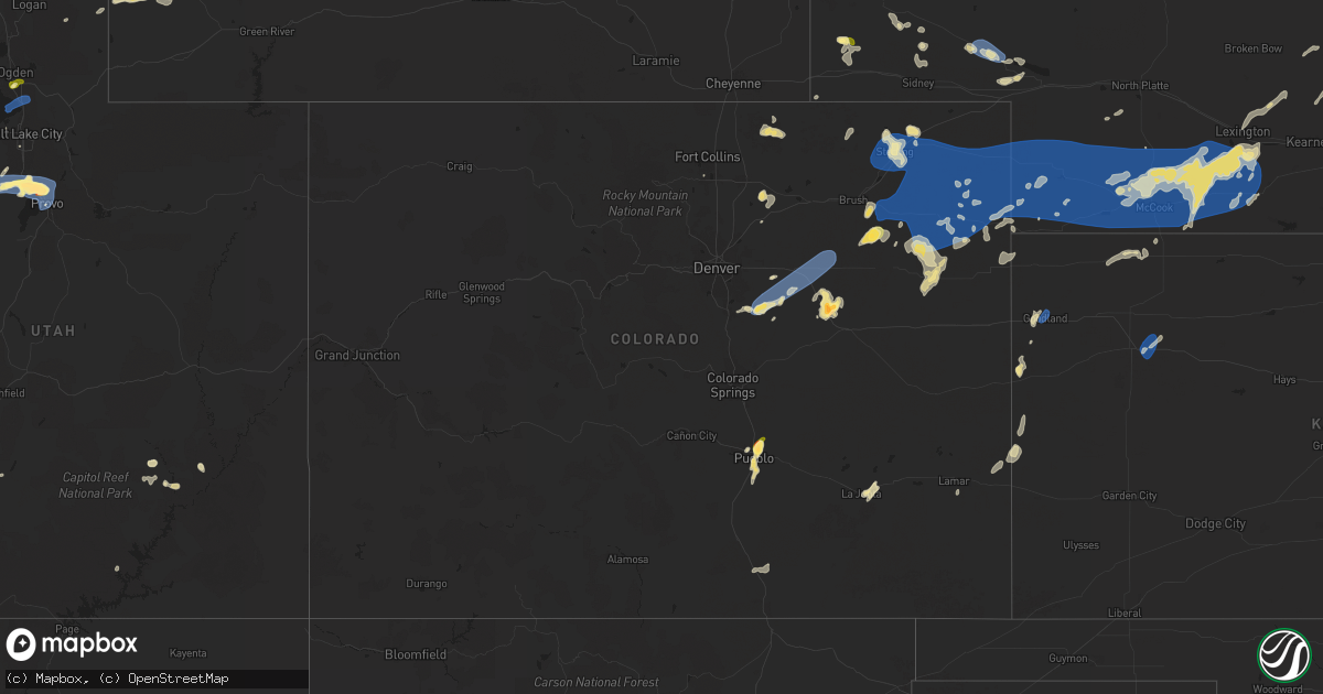
Hail Map in Colorado on August 13, 2024
Get this storm
August 13 map
$229
one time, instant access
Download today. No call, no setup
Keep the $229
Bought the map and want the full workflow? Apply the entire $229 to a subscription within 7 days. None of it is wasted.
Every map, not just this one
This buys you this map. Subscription and you get every map we run, in the markets you choose from a few cities to whole states to nationwide. Plus real-time alerts the moment a storm fires.
Contact data
Name, contact info, occupancy, even credit band for addresses in the footprint. You go from where it hit to who to call.
Become the source they trust
Unlimited branding weather history reports on demand. You already have the documented answer ready for the property owner, and you are the one who showed up with it.
Property data and RoofTrace estimates
Pull up any address you have got, its value and the exact code rules for that jurisdiction, straight from One Click Code. Then RoofTrace estimates the squares, pitch, and roof value, priced the way you price.
Storm reports in Colorado
Colorado
| Date | Description |
|---|---|
| 08/13/20246:28 PM CDT | A local report indicates 60 MPH wind near 2 ENE Deer Trail |
| 08/13/20245:50 PM CDT | A local report indicates 58 MPH wind near 8 WNW Hoyt Beet Dump |
| 08/13/20245:48 PM CDT | A local report indicates 73 MPH wind near 6 ESE Byers |
| 08/13/20245:15 PM CDT | A local report indicates 59 MPH wind near 2 WNW Cornish |
| 08/13/20245:04 PM CDT | Branches snapped on some smaller trees... And one window broken on the front of a convenience store. |
| 08/13/20244:50 PM CDT | Mesonet station dw4786 elizabeth. |
| 08/13/20244:46 PM CDT | A local report indicates 83 MPH wind near 4 NNE Elizabeth |
| 08/13/20244:46 PM CDT | A local report indicates 65 MPH wind near 5 NE Ponderosa Park |
| 08/13/20244:46 PM CDT | Fire department reported a collapsed outbuilding due to wind damage near intersection of private road 160 and county road 21. |
| 08/13/20244:44 PM CDT | A local report indicates 67 MPH wind near 4 NE Elizabeth |
| 08/13/20244:37 PM CDT | Wind gust is estimated. No damage aside from some leaves getting stripped off of trees. |
| 08/13/20244:30 PM CDT | Blown down trees and limbs up to 16 inches in diameter. Time estimated by radar. |
| 08/13/20244:30 PM CDT | Roof blown off of building. Time is estimated based on radar. |
| 08/13/20244:23 PM CDT | Tree down in a backyard. Extensive damage to the tree and branches. The tree came down on and destroyed a wooden fence. |
| 08/13/20244:20 PM CDT | Trees down mineral palace park. |
| 08/12/20248:54 PM CDT | Corrects previous non-tstm wnd gst report from 8 s holyoke. Mesonet station co048 us 385 holyoke. |
| 08/12/20248:30 PM CDT | Hail lasted 3-4 minutes according to spotter. |
| 08/12/20248:22 PM CDT | A local report indicates 63 MPH wind near 4 W Fairfield |
| 08/12/20247:32 PM CDT | A local report indicates 70 MPH wind near 4 NNW Iliff |
| 08/12/20247:24 PM CDT | Awos station kako akron. |
All States Impacted by Hail Map on August 13, 2024
Cities Impacted by Hail Map on August 13, 2024
- Oswego, KS
- Malta, ID
- Bancroft, ID
- Bamberg, SC
- Moore, ID
- Rockland, ID
- Arimo, ID
- Aguilar, CO
- Ruffin, SC
- Arbon, ID
- Pocatello, ID
- Howe, ID
- Mccammon, ID
- Terreton, ID
- Glen Ullin, ND
- Trinidad, CO
- Harrisburg, NE
- Holbrook, ID
- Wendover, UT
- Randolph, UT
- Malad City, ID
- Cokeville, WY
- Pueblo, CO
- Gulfport, MS
- Long Beach, MS
- Mandan, ND
- Payson, AZ
- Franktown, CO
- Avondale, CO
- Roberts, ID
- Port Allen, LA
- Loveland, CO
- Parker, CO
- Kimball, NE
- Kanab, UT
- Menan, ID
- Lewisville, ID
- Rigby, ID
- Dugway, UT
- Elizabeth, CO
- Kiowa, CO
- Kemmerer, WY
- Hanksville, UT
- Bridgeport, NE
- Bayard, NE
- Antimony, UT
- Lamar, CO
- Ault, CO
- Bennett, CO
- Grover, CO
- Keenesburg, CO
- Bismarck, ND
- La Junta, CO
- Kersey, CO
- Briggsdale, CO
- La Salle, CO
- Deer Trail, CO
- Dalton, NE
- Menoken, ND
- Clifton, ID
- Holly, CO
- Las Animas, CO
- Byers, CO
- Broadwater, NE
- Grantsville, UT
- Rush Valley, UT
- Stockton, UT
- Roggen, CO
- Dayton, ID
- Bushnell, NE
- Tribune, KS
- Tooele, UT
- Clearfield, UT
- Sheridan Lake, CO
- Sterling, ND
- Agate, CO
- Winslow, AZ
- Hill Afb, UT
- Magna, UT
- Layton, UT
- Ogden, UT
- Centerville, UT
- Kaysville, UT
- Farmington, UT
- Strasburg, CO
- Fort Morgan, CO
- Stoneham, CO
- Weskan, KS
- Cornish, UT
- Clarkston, UT
- Dix, NE
- Herriman, UT
- Driscoll, ND
- Oshkosh, NE
- Lisco, NE
- Eagle Mountain, UT
- Akron, CO
- Woodrow, CO
- Saratoga Springs, UT
- Cedar Valley, UT
- Trenton, UT
- Brush, CO
- Lehi, UT
- Vineyard, UT
- Orem, UT
- American Fork, UT
- Lindon, UT
- Pleasant Grove, UT
- Riverton, UT
- Draper, UT
- Sundance, WY
- Newton, UT
- Iliff, CO
- Steele, ND
- Dawson, ND
- Gurley, NE
- Sterling, CO
- Limon, CO
- Salt Lake City, UT
- Provo, UT
- Otis, CO
- Lewellen, NE
- Goodland, KS
- Peetz, CO
- Logan, UT
- Alpine, UT
- Merino, CO
- Atwood, CO
- Fleming, CO
- Haxtun, CO
- Yuma, CO
- Cope, CO
- Eckley, CO
- Anton, CO
- Flagler, CO
- Wray, CO
- Paoli, CO
- Amherst, CO
- Holyoke, CO
- Venango, NE
- Vernon, CO
- Idalia, CO
- Joes, CO
- Big Springs, NE
- Grinnell, KS
- Brule, NE
- Hoxie, KS
- Parks, NE
- Haigler, NE
- Palisade, NE
- Culbertson, NE
- Champion, NE
- Oakley, KS
- Imperial, NE
- Wauneta, NE
- Enders, NE
- Benkelman, NE
- Hayes Center, NE
- McCook, NE
- Maywood, NE
- Saint Francis, KS
- Beaver City, NE
- Arapahoe, NE
- Curtis, NE
- Bartley, NE
- Indianola, NE
- Cambridge, NE
- Moorefield, NE
- Max, NE
- Trenton, NE
- Stratton, NE
- Elsie, NE
- Eustis, NE
- Stockville, NE
- Edison, NE
- Lebanon, NE
- Danbury, NE
- Lindon, CO
- New Raymer, CO
- Colorado Springs, CO
- Seibert, CO
- Oxford, NE
- Yoder, CO
- Castle Rock, CO
- Holbrook, NE
- Elwood, NE
- Farnam, NE
- Wallace, NE
- Dickens, NE
- Bertrand, NE
- Smithfield, NE
- Lexington, NE
- Eddyville, NE
- Sumner, NE
- Overton, NE
- Miller, NE
- Ludell, KS
- Atwood, KS
- Wilsonville, NE
- Hendley, NE
- Ravenna, NE
- Hazard, NE
- Pleasanton, NE
- Oberlin, KS
- Mason City, NE
- Grand Island, NE
- Saint Libory, NE
- Herndon, KS
- Loomis, NE
- Grant, NE
- Hampton, NE
- Chapman, NE
- Rockville, NE
- Saint Paul, NE
- Lame Deer, MT
- Marquette, NE
- Central City, NE
- Bradshaw, NE
- Polk, NE
- Archer, NE
- Dannebrog, NE
- Palmer, NE
- Benedict, NE
- Stromsburg, NE
- Arcadia, NE
- Loup City, NE
- Clarks, NE
- Gresham, NE
- Osceola, NE
- Wolbach, NE
- Shelby, NE
- Otter, MT
- Greenwood, NE
- Waverly, NE
- Nebraska City, NE
- Avoca, NE
- Ashland, NE
- Weeping Water, NE
- Hamburg, IA
- Rock Port, MO
- Louisville, NE
- Plattsmouth, NE
- Springfield, NE
- Westboro, MO
- Maryville, MO
- Ravenwood, MO
- Stanberry, MO
- Clyde, MO
- Gretna, NE
- Cedar Creek, NE
- Elkland, MO
- McFall, MO
- Darlington, MO
- Albany, MO
- Coin, IA
- Pattonsburg, MO
- Pickering, MO
- Hopkins, MO
- Stanton, NE
- Wisner, NE
- Pilger, NE
- Breckenridge, MO


