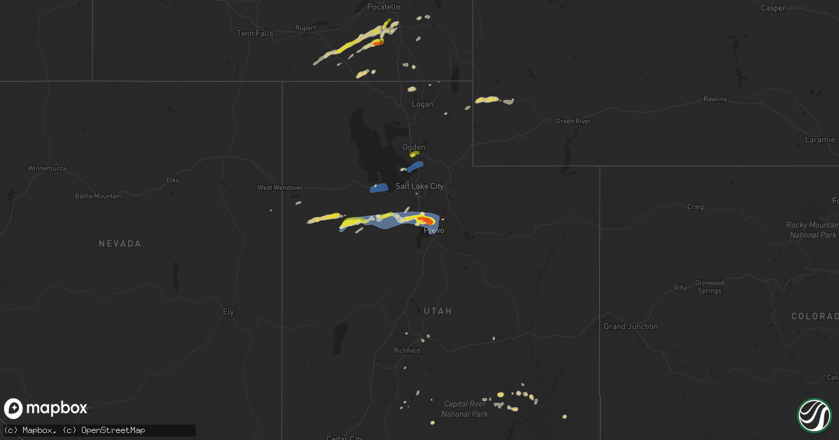
Hail Map on August 13, 2024
Get this storm
August 13 map
$229
one time, instant access
Download today. No call, no setup
Keep the $229
Bought the map and want the full workflow? Apply the entire $229 to a subscription within 7 days. None of it is wasted.
Every map, not just this one
This buys you this map. Subscription and you get every map we run, in the markets you choose from a few cities to whole states to nationwide. Plus real-time alerts the moment a storm fires.
Contact data
Name, contact info, occupancy, even credit band for addresses in the footprint. You go from where it hit to who to call.
Become the source they trust
Unlimited branding weather history reports on demand. You already have the documented answer ready for the property owner, and you are the one who showed up with it.
Property data and RoofTrace estimates
Pull up any address you have got, its value and the exact code rules for that jurisdiction, straight from One Click Code. Then RoofTrace estimates the squares, pitch, and roof value, priced the way you price.
States Impacted by Hail Map on August 13, 2024
Storm reports
Idaho
| Date | Description |
|---|---|
| 08/13/20246:10 PM CDT | Sheep creek hills id pacficorp mesonet. |
| 08/13/20244:42 PM CDT | A local report indicates 1.00 inch wind near 3 WNW Lewisville |
| 08/13/20244:41 PM CDT | Rocky mountain power reports power outage in the area due to thunderstorm winds. |
| 08/13/20244:35 PM CDT | Large tree limb snapped off. Time estimated based on radar. |
| 08/13/20243:00 PM CDT | Measured at the scout mountain campground. Hail was ongoing at the time of the report. |
| 08/13/20242:58 PM CDT | Multiple reports via social media of quarter size hail at idaho national laboratory. Report of significant ground accumulation. Time estimated based on radar. |
| 08/13/20242:45 PM CDT | Delayed report passed along from butte county em of crop damage from hail of unknown size. Time estimated. |
| 08/13/202411:15 AM CDT | A local report indicates 59 MPH wind near 14 SSE Malta |
Colorado
| Date | Description |
|---|---|
| 08/13/20246:28 PM CDT | A local report indicates 60 MPH wind near 2 ENE Deer Trail |
| 08/13/20245:50 PM CDT | A local report indicates 58 MPH wind near 8 WNW Hoyt Beet Dump |
| 08/13/20245:48 PM CDT | A local report indicates 73 MPH wind near 6 ESE Byers |
| 08/13/20245:15 PM CDT | A local report indicates 59 MPH wind near 2 WNW Cornish |
| 08/13/20245:04 PM CDT | Branches snapped on some smaller trees... And one window broken on the front of a convenience store. |
| 08/13/20244:50 PM CDT | Mesonet station dw4786 elizabeth. |
| 08/13/20244:46 PM CDT | A local report indicates 83 MPH wind near 4 NNE Elizabeth |
| 08/13/20244:46 PM CDT | Fire department reported a collapsed outbuilding due to wind damage near intersection of private road 160 and county road 21. |
| 08/13/20244:46 PM CDT | A local report indicates 65 MPH wind near 5 NE Ponderosa Park |
| 08/13/20244:44 PM CDT | A local report indicates 67 MPH wind near 4 NE Elizabeth |
| 08/13/20244:37 PM CDT | Wind gust is estimated. No damage aside from some leaves getting stripped off of trees. |
| 08/13/20244:30 PM CDT | Roof blown off of building. Time is estimated based on radar. |
| 08/13/20244:30 PM CDT | Blown down trees and limbs up to 16 inches in diameter. Time estimated by radar. |
| 08/13/20244:23 PM CDT | Tree down in a backyard. Extensive damage to the tree and branches. The tree came down on and destroyed a wooden fence. |
| 08/13/20244:20 PM CDT | Trees down mineral palace park. |
| 08/12/20248:54 PM CDT | Corrects previous non-tstm wnd gst report from 8 s holyoke. Mesonet station co048 us 385 holyoke. |
| 08/12/20248:30 PM CDT | Hail lasted 3-4 minutes according to spotter. |
| 08/12/20248:22 PM CDT | A local report indicates 63 MPH wind near 4 W Fairfield |
| 08/12/20247:32 PM CDT | A local report indicates 70 MPH wind near 4 NNW Iliff |
| 08/12/20247:24 PM CDT | Awos station kako akron. |
South Carolina
| Date | Description |
|---|---|
| 08/13/20241:08 PM CDT | Corrects previous tstm wnd dmg report from 5 nnw edisto. Orangeburg county dispatch reported trees down along shillings bridge rd. Time estimated by radar. |
| 08/13/20241:05 PM CDT | Orangeburg county dispatch reported trees down along shillings bridge rd. Time estimated by radar. |
North Dakota
| Date | Description |
|---|---|
| 08/12/20247:16 PM CDT | Broadcast media relayed a photo of a large tree that had broken off at its base and fallen over. Viewer estimated time of the damage to be some time before 6:45 pm cdt. |
Mississippi
| Date | Description |
|---|---|
| 08/13/20243:59 PM CDT | Asos station kgpt gulfport-biloxi intl airport. |
Nebraska
| Date | Description |
|---|---|
| 08/13/202412:45 AM CDT | Corrects time and type of of report from 5 se kearney. Social media mage of a part of an old barn that collapsed. |
| 08/13/202412:10 AM CDT | Several branches down across a yard including a 10-12 inch diameter branch. |
| 08/12/202411:47 PM CDT | Image of several branches across the road. |
| 08/12/202411:16 PM CDT | A local report indicates 69 MPH wind near 1 E Mccook |
| 08/12/202410:24 PM CDT | Tree broke off in their yard. |
| 08/12/202410:15 PM CDT | A local report indicates 75 MPH wind near Madrid |
| 08/12/20249:58 PM CDT | A local report indicates 58 MPH wind near 12 N Imperial |
| 08/12/20249:47 PM CDT | A local report indicates 58 MPH wind near 1 ESE Imperial |
| 08/12/20247:23 PM CDT | A local report indicates 62 MPH wind near 6 ESE Oshkosh |
Utah
| Date | Description |
|---|---|
| 08/13/20246:55 PM CDT | Measured at a personal weather station in saratoga springs. |
| 08/13/20246:48 PM CDT | Quarter sized hail estimates from a photo received via social media. Time estimated by radar. |
| 08/13/20246:25 PM CDT | A social media post showed pictures of a large tree snapped in half in magna. |
| 08/13/20246:10 PM CDT | Measured at the sr-177 at mp 5 udot rwis site in kaysville. |
| 08/13/20246:10 PM CDT | Photo of hail from social media at 650 n in clearfield. |
| 08/13/20246:06 PM CDT | Social media report of 1 inch hail in sunset. Time estimated by radar. |
| 08/13/20246:04 PM CDT | A local report indicates 62 MPH wind near 5 SE Clover |
| 08/13/20246:04 PM CDT | Measured at the clover upr site. |
| 08/13/20245:55 PM CDT | Measured at the cedar mountain raws site. |
| 08/13/20245:20 PM CDT | A local report indicates 59 MPH wind near 10 NNW Grantsville |
| 08/13/20245:20 PM CDT | Measured at the dolomite udot rwis site along interstate 80. |
| 08/13/20244:55 PM CDT | A local report indicates 64 MPH wind near 12 W Dugway |
| 08/13/20244:40 PM CDT | Mesonet station dpg09 playa station. |
| 08/13/20244:20 PM CDT | A local report indicates 58 MPH wind near 25 SSW Clive |
| 08/12/20247:51 PM CDT | A local report indicates 1.00 inch wind near 2 W Lindon |
| 08/12/20247:32 PM CDT | Measured at the orem udot rwis site along interstate 15. Visibility at the time of observation was one third of a mile. |
| 08/12/20247:30 PM CDT | Measured at the provo canyon pacificorp site. |
| 08/12/20247:30 PM CDT | Measured at the provo canyon pacificorp site. |
| 08/12/20247:20 PM CDT | Measured at the udot rwis site at provo. |
| 08/12/20247:18 PM CDT | Received via social media. Location approximate. |
| 08/12/20247:10 PM CDT | Measured at the wanship pacificorp site. |
| 08/12/20247:06 PM CDT | Received via social media. Location approximate and time estimated by radar. |
| 08/12/20247:01 PM CDT | A local report indicates 1.00 inch wind near 3 SE Saratoga Springs |
Kansas
| Date | Description |
|---|---|
| 08/12/20249:53 PM CDT | Asos station kgld goodland. |
| 08/12/20249:12 PM CDT | Wxlink site wpeweather. |
| 08/12/20247:40 PM CDT | Hail ranged from penny to nickel in size. |
Wyoming
| Date | Description |
|---|---|
| 08/13/20246:53 PM CDT | Asos station kriw riverton airport ; t-storm outflow. |
Cities Impacted by Hail Map on August 13, 2024
- Oswego, KS
- Malta, ID
- Bancroft, ID
- Bamberg, SC
- Moore, ID
- Rockland, ID
- Arimo, ID
- Aguilar, CO
- Ruffin, SC
- Arbon, ID
- Pocatello, ID
- Howe, ID
- Mccammon, ID
- Terreton, ID
- Glen Ullin, ND
- Trinidad, CO
- Harrisburg, NE
- Holbrook, ID
- Wendover, UT
- Randolph, UT
- Malad City, ID
- Cokeville, WY
- Pueblo, CO
- Gulfport, MS
- Long Beach, MS
- Mandan, ND
- Payson, AZ
- Franktown, CO
- Avondale, CO
- Roberts, ID
- Port Allen, LA
- Loveland, CO
- Parker, CO
- Kimball, NE
- Kanab, UT
- Menan, ID
- Lewisville, ID
- Rigby, ID
- Dugway, UT
- Elizabeth, CO
- Kiowa, CO
- Kemmerer, WY
- Hanksville, UT
- Bridgeport, NE
- Bayard, NE
- Antimony, UT
- Lamar, CO
- Ault, CO
- Bennett, CO
- Grover, CO
- Keenesburg, CO
- Bismarck, ND
- La Junta, CO
- Kersey, CO
- Briggsdale, CO
- La Salle, CO
- Deer Trail, CO
- Dalton, NE
- Menoken, ND
- Clifton, ID
- Holly, CO
- Las Animas, CO
- Byers, CO
- Broadwater, NE
- Grantsville, UT
- Rush Valley, UT
- Stockton, UT
- Roggen, CO
- Dayton, ID
- Bushnell, NE
- Tribune, KS
- Tooele, UT
- Clearfield, UT
- Sheridan Lake, CO
- Sterling, ND
- Agate, CO
- Winslow, AZ
- Hill Afb, UT
- Magna, UT
- Layton, UT
- Ogden, UT
- Centerville, UT
- Kaysville, UT
- Farmington, UT
- Strasburg, CO
- Fort Morgan, CO
- Stoneham, CO
- Weskan, KS
- Cornish, UT
- Clarkston, UT
- Dix, NE
- Herriman, UT
- Driscoll, ND
- Oshkosh, NE
- Lisco, NE
- Eagle Mountain, UT
- Akron, CO
- Woodrow, CO
- Saratoga Springs, UT
- Cedar Valley, UT
- Trenton, UT
- Brush, CO
- Lehi, UT
- Vineyard, UT
- Orem, UT
- American Fork, UT
- Lindon, UT
- Pleasant Grove, UT
- Riverton, UT
- Draper, UT
- Sundance, WY
- Newton, UT
- Iliff, CO
- Steele, ND
- Dawson, ND
- Gurley, NE
- Sterling, CO
- Limon, CO
- Salt Lake City, UT
- Provo, UT
- Otis, CO
- Lewellen, NE
- Goodland, KS
- Peetz, CO
- Logan, UT
- Alpine, UT
- Merino, CO
- Atwood, CO
- Fleming, CO
- Haxtun, CO
- Yuma, CO
- Cope, CO
- Eckley, CO
- Anton, CO
- Flagler, CO
- Wray, CO
- Paoli, CO
- Amherst, CO
- Holyoke, CO
- Venango, NE
- Vernon, CO
- Idalia, CO
- Joes, CO
- Big Springs, NE
- Grinnell, KS
- Brule, NE
- Hoxie, KS
- Parks, NE
- Haigler, NE
- Palisade, NE
- Culbertson, NE
- Champion, NE
- Oakley, KS
- Imperial, NE
- Wauneta, NE
- Enders, NE
- Benkelman, NE
- Hayes Center, NE
- McCook, NE
- Maywood, NE
- Saint Francis, KS
- Beaver City, NE
- Arapahoe, NE
- Curtis, NE
- Bartley, NE
- Indianola, NE
- Cambridge, NE
- Moorefield, NE
- Max, NE
- Trenton, NE
- Stratton, NE
- Elsie, NE
- Eustis, NE
- Stockville, NE
- Edison, NE
- Lebanon, NE
- Danbury, NE
- Lindon, CO
- New Raymer, CO
- Colorado Springs, CO
- Seibert, CO
- Oxford, NE
- Yoder, CO
- Castle Rock, CO
- Holbrook, NE
- Elwood, NE
- Farnam, NE
- Wallace, NE
- Dickens, NE
- Bertrand, NE
- Smithfield, NE
- Lexington, NE
- Eddyville, NE
- Sumner, NE
- Overton, NE
- Miller, NE
- Ludell, KS
- Atwood, KS
- Wilsonville, NE
- Hendley, NE
- Ravenna, NE
- Hazard, NE
- Pleasanton, NE
- Oberlin, KS
- Mason City, NE
- Grand Island, NE
- Saint Libory, NE
- Herndon, KS
- Loomis, NE
- Grant, NE
- Hampton, NE
- Chapman, NE
- Rockville, NE
- Saint Paul, NE
- Lame Deer, MT
- Marquette, NE
- Central City, NE
- Bradshaw, NE
- Polk, NE
- Archer, NE
- Dannebrog, NE
- Palmer, NE
- Benedict, NE
- Stromsburg, NE
- Arcadia, NE
- Loup City, NE
- Clarks, NE
- Gresham, NE
- Osceola, NE
- Wolbach, NE
- Shelby, NE
- Otter, MT
- Greenwood, NE
- Waverly, NE
- Nebraska City, NE
- Avoca, NE
- Ashland, NE
- Weeping Water, NE
- Hamburg, IA
- Rock Port, MO
- Louisville, NE
- Plattsmouth, NE
- Springfield, NE
- Westboro, MO
- Maryville, MO
- Ravenwood, MO
- Stanberry, MO
- Clyde, MO
- Gretna, NE
- Cedar Creek, NE
- Elkland, MO
- McFall, MO
- Darlington, MO
- Albany, MO
- Coin, IA
- Pattonsburg, MO
- Pickering, MO
- Hopkins, MO
- Stanton, NE
- Wisner, NE
- Pilger, NE
- Breckenridge, MO