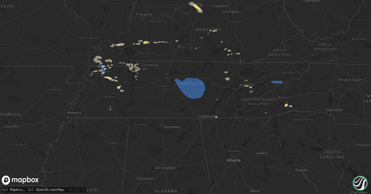
Hail Map in Tennessee on August 12, 2023
Get this storm
August 12 map
$229
one time, instant access
Download today. No call, no setup
Keep the $229
Bought the map and want the full workflow? Apply the entire $229 to a subscription within 7 days. None of it is wasted.
Every map, not just this one
This buys you this map. Subscription and you get every map we run, in the markets you choose from a few cities to whole states to nationwide. Plus real-time alerts the moment a storm fires.
Contact data
Name, contact info, occupancy, even credit band for addresses in the footprint. You go from where it hit to who to call.
Become the source they trust
Unlimited branding weather history reports on demand. You already have the documented answer ready for the property owner, and you are the one who showed up with it.
Property data and RoofTrace estimates
Pull up any address you have got, its value and the exact code rules for that jurisdiction, straight from One Click Code. Then RoofTrace estimates the squares, pitch, and roof value, priced the way you price.
Storm reports in Tennessee
Tennessee
| Date | Description |
|---|---|
| 08/12/20234:55 PM CDT | Large tree along the side of mcguire rd near the intersection of shields ridge rd. |
| 08/12/20234:26 PM CDT | Several trees down along with a sign blown over. |
| 08/12/20233:47 PM CDT | Trees down blocking traffic... Curly lane @ garners landing. |
| 08/12/20233:45 PM CDT | A few trees down. |
| 08/12/20233:42 PM CDT | Trees and power lines down. |
| 08/12/20233:20 PM CDT | A few trees down across the area. |
| 08/12/20233:20 PM CDT | Tree down blocking lane of traffic near s chilhowee dr and green valley dr. |
| 08/12/20233:15 PM CDT | Trees down. |
| 08/12/20233:04 PM CDT | Tree down blocking skyview dr. |
| 08/12/20233:02 PM CDT | Multiple trees down. |
| 08/12/20232:55 PM CDT | Recorded on a tempest home weather station. |
| 08/12/20232:51 PM CDT | Several trees down artella dr and brown rd. |
| 08/12/20232:48 PM CDT | Tree down blocking traffic on glenoaks dr and coster rd. |
| 08/12/20232:48 PM CDT | Tree down blocking traffic at bays mtn rd and pratt rd. Several trees down. |
| 08/12/20232:45 PM CDT | Several trees down. |
| 08/12/20232:39 PM CDT | A few trees down. |
| 08/12/20232:34 PM CDT | Multiple trees down. |
| 08/12/20232:32 PM CDT | Report from mping: 1-inch tree limbs broken; shingles blown off. Several trees down. |
| 08/12/20232:30 PM CDT | A few trees down. |
| 08/12/20232:25 PM CDT | Several trees down across the area. |
| 08/12/20232:20 PM CDT | Multiple trees down. |
| 08/12/20232:14 PM CDT | Several trees down. |
| 08/12/20232:03 PM CDT | A local report indicates 1.00 inch wind near Halls |
| 08/12/20232:02 PM CDT | Report from mping: quarter |
| 08/12/20231:59 PM CDT | A few trees down. |
| 08/12/20231:58 PM CDT | Tree down on tazewell pike. |
| 08/12/20231:55 PM CDT | Facebook photo of a tree down across a road in fentress county. |
| 08/12/20231:54 PM CDT | Several trees down. |
| 08/12/20231:51 PM CDT | Tree down near chapman hwy and stone rd. |
| 08/12/20231:45 PM CDT | Report of multiple trees down in estill springs along ut farm rd. Time estimated by radar. |
| 08/12/20231:43 PM CDT | Several trees down. |
| 08/12/20231:36 PM CDT | Trees and power lines down. |
| 08/12/20231:33 PM CDT | Several trees down. |
| 08/12/20231:33 PM CDT | Several trees down. |
| 08/12/20231:25 PM CDT | Trees and power lines down across east and southeast white county. |
| 08/12/20231:20 PM CDT | Facebook photo of tree down and shed damaged in irving college. |
| 08/12/20231:16 PM CDT | A few trees down. |
| 08/12/20231:16 PM CDT | A few trees down. |
| 08/12/20231:12 PM CDT | Report of three trees down near tullahoma. Time estimated by radar. |
| 08/12/20231:06 PM CDT | Several trees down. |
| 08/12/202312:52 PM CDT | Multiple trees down across the county. |
| 08/12/202312:45 PM CDT | Tspotter report of tree down across horse mountain road. |
| 08/12/202312:32 PM CDT | Tspotter report of 5 mature trees blown down with one falling on a house causing moderate damage. |
| 08/12/202312:30 PM CDT | Tree down on home that destroyed back porch and carport. |
| 08/12/202312:27 PM CDT | Tspotter report of roof damage to barn in wheel. |
| 08/12/202312:12 PM CDT | Photo received of two tress down across powells chapel road. Time is radar estimated. |
| 08/12/202312:06 PM CDT | Tree limbs down on power lines in 1100 block of couchville pike. |
| 08/12/202312:04 PM CDT | Tree down on house at 1510 couchville pike. |
| 08/12/202311:47 AM CDT | Tspotter reports and photos of several trees down near the factory with one crushing a shed. |
| 08/12/202311:45 AM CDT | Photo received of a very large tree down by dry fork road/bobel lane. Time is radar estimated. |
| 08/12/202311:45 AM CDT | Tspotter report of tree down in williams grove area of brentwood. |
| 08/12/202311:44 AM CDT | Tv meteorologist reported 60 mph wind gusts in indian lake area of hendersonville. |
| 08/12/202311:42 AM CDT | Tspotter video of tree down on house in the 1600 block of 5th ave in germantown. |
| 08/12/202311:37 AM CDT | Tree down on hwy 100 near whippoorwill hill blocking both lanes of traffic. |
| 08/12/202311:32 AM CDT | Report of trees down with scattered power outages in the fairview area. |
| 08/12/202311:30 AM CDT | Tspotter photo of tree down across road in primm springs. |
| 08/12/202311:25 AM CDT | Tspotter photo of tree down on road in kingston springs. |
| 08/12/202311:25 AM CDT | Photo of tree down in dickson on hurt lane. |
| 08/12/202311:22 AM CDT | Large tree uprooted and power lines down on mcfarlin rd. |
| 08/12/202311:22 AM CDT | Trees down blocking highway 70 west between dickson and charlotte. |
| 08/12/202311:20 AM CDT | Corrected for wrong time in previous report. Tspotter photo of trees down across roads in whites creek. |
| 08/12/202311:20 AM CDT | Trees and power lines down across hwy 76. |
| 08/12/202311:15 AM CDT | Trees down and estimated wind gusts of 60 mph...pea size hail...power outages...several trees hit by lightning. |
| 08/12/202311:12 AM CDT | Two trees snapped on myatt st in downtown dickson. |
| 08/12/202311:10 AM CDT | Spotter reported a tree was struck by lightning... Causing it to fall on a transformer 2 miles south of greenbrier in robertson county. |
| 08/12/202311:00 AM CDT | Corrects time of previous tstm wnd dmg report from 1 nne ashland city. Facebook report of trees down across frey st and hwy 49 in ashland city. |
| 08/12/202310:20 AM CDT | Tspotter photo of trees down across roads in whites creek. |
| 08/12/202310:00 AM CDT | Facebook report of trees down across frey st and hwy 49 in ashland city. |
| 08/12/20239:15 AM CDT | Reported multiple trees down/across the road between woodland mills and hickman |
| 08/12/20239:15 AM CDT | Large tree down blocking hwy 116 west of fulton. Also brought down some power lines. |
All States Impacted by Hail Map on August 12, 2023
Cities Impacted by Hail Map on August 12, 2023
- Columbus, IN
- Kenton, OH
- Bellevue, OH
- Castalia, OH
- Sandusky, OH
- Huron, OH
- Morral, OH
- Marion, OH
- Linesville, PA
- Conneautville, PA
- Bowling Green, KY
- Nashville, IN
- Gravel Switch, KY
- Bradfordsville, KY
- Whitewater, MO
- Troy, TN
- Union City, TN
- Rives, TN
- Martinsville, IN
- Mooresville, IN
- Bronston, KY
- Ridgely, TN
- Ada, OH
- Kenton, TN
- Belton, KY
- Drakesboro, KY
- Saint Charles, KY
- Nortonville, KY
- Scott City, MO
- Chaffee, MO
- Oran, MO
- Benton, MO
- Fulton, KY
- South Fulton, TN
- Seymour, IN
- Republic, OH
- Edmonton, KY
- Knob Lick, KY
- McKenzie, TN
- Alger, OH
- Campbellsburg, IN
- White Plains, KY
- Lewisburg, KY
- Rochester, KY
- Morgantown, KY
- Murray, KY
- Burnside, KY
- Paducah, KY
- West Paducah, KY
- Williamsburg, KY
- Corbin, KY
- Washington, IN
- Cannelburg, IN
- Loogootee, IN
- Montgomery, IN
- Jasper, IN
- Otwell, IN
- Orleans, IN
- Salem, IN
- Palmyra, TN
- East Prairie, MO
- Bertrand, MO
- Dover, TN
- Indian Mound, TN
- Cedar Grove, TN
- Huntingdon, TN
- Stewart, TN
- Big Sandy, TN
- Chanute, KS
- Benedict, KS
- Yates Center, KS
- Buffalo, KS
- Dukedom, TN
- Morgantown, IN
- Nineveh, IN
- Dawson Springs, KY
- Princeton, KY
- Lebanon, KY
- Fort Scott, KS
- Redfield, KS
- Wildersville, TN
- Grand Rivers, KY
- Smithland, KY
- Hornbeak, TN
- Louisville, KY
- Martin, TN
- Hickman, KY
- New Madrid, MO
- Clinton, KY
- Charleston, MO
- Brookport, IL
- Bethel Springs, TN
- Hornsby, TN
- Greenfield, TN
- Rutherford, TN
- Waverly, TN
- Whitley City, KY
- Parkers Lake, KY
- McIntire, IA
- Lima, OH
- Science Hill, KY
- Liberty, KY
- Bethelridge, KY
- Windsor, KY
- Greensburg, KY
- Vanlue, OH
- Findlay, OH
- Carey, OH
- Alvada, OH
- Mayfield, KY
- Wingo, KY
- Dola, OH
- Ledbetter, KY
- Fostoria, OH
- Tennessee Ridge, TN
- Trafalgar, IN
- Monticello, KY
- Fredonia, KY
- Campbellsville, KY
- Glasgow, KY
- Hazel, KY
- Buchanan, TN
- New Concord, KY
- Shepherdsville, KY
- Mount Washington, KY
- Sikeston, MO
- Matthews, MO
- Trezevant, TN
- Harrod, OH
- Bluffton, OH
- Beechmont, KY
- Beech Creek, KY
- Greenville, KY
- Browder, KY
- Palmyra, IN
- Bradford, TN
- Atwood, TN
- Cumberland City, TN
- Yuma, TN
- Roachdale, IN
- Attica, IN
- Obion, TN
- Freetown, IN
- Franklin, IN
- Brooklyn, IN
- Bargersville, IN
- Arcadia, OH
- New Albany, IN
- Lanesville, IN
- Taylorsville, KY
- Elizabeth, IN
- Georgetown, IN
- Arlington, OH
- Mount Blanchard, OH
- Cairo, IL
- Roundhill, KY
- Brownsville, KY
- Lexington, TN
- Oakland, KY
- Beaverdam, OH
- Columbus Grove, OH
- Tiffin, OH
- Green Springs, OH
- Henderson, TN
- Bell City, MO
- New Bloomington, OH
- Jenera, OH
- Waynesfield, OH
- La Rue, OH
- Belle Center, OH
- Bellville, OH
- Butler, OH
- Perrysville, OH
- Loudonville, OH
- Knoxville, TN
- Newfield, NY
- Ithaca, NY
- Spencer, NY
- Van Etten, NY
- Seymour, TN
- Franklin, PA
- Cooperstown, PA
- Oil City, PA
- Titusville, PA
- Pleasantville, PA
- Killbuck, OH
- Millersburg, OH
- Glenmont, OH
- Big Prairie, OH
- Kent, OH
- Ravenna, OH
- Rootstown, OH
- Nemo, SD
- Deadwood, SD
- Rapid City, SD
- Hill City, SD
- Black Hawk, SD
- Diamond, OH
- Newton Falls, OH
- Lake Milton, OH
- North Jackson, OH
- Berlin Center, OH
- New Philadelphia, OH
- Dover, OH
- Youngstown, OH
- Canfield, OH
- Apache, OK
- Eldorado, OK
- Mount Juliet, TN
- Lebanon, TN
- Murfreesboro, TN
- Lascassas, TN
- Watertown, TN
- Milton, TN
- Brush Creek, TN
- Hickman, TN
- Alexandria, TN
- Waldron, KS
- Liberty, TN
- Auburntown, TN
- Readyville, TN
- Woodbury, TN
- Bradyville, TN
- Dowelltown, TN
- Lancaster, TN
- Manchester, TN
- Smithville, TN
- Morrison, TN
- Mcminnville, TN
- Christiana, TN
- Baxter, TN
- Sparta, TN
- Silver Point, TN
- Buffalo Valley, TN
- Dennison, OH
- Sherrodsville, OH
- Bowerston, OH
- Emporium, PA
- Driftwood, PA
- Sinnamahoning, PA
- Westport, PA
- Pottersdale, PA
- Coatesville, PA
- Kennett Square, PA
- West Chester, PA
- Parrottsville, TN
- Greeneville, TN
- Marshall, NC
- Campbell, OH
- Struthers, OH
- Lowellville, OH
- Altus, OK
- Headrick, OK
- Keystone, SD
- Elmer, OK
- Elgin, OK
- Mills River, NC
- Horse Shoe, NC
- Hendersonville, NC
- Hermosa, SD
- Caputa, SD
- Rock Island, TN
- Walling, TN
- Quebeck, TN
- Spencer, TN
- Doyle, TN
- Fletcher, OK
- Hankins, NY
- Long Eddy, NY
- Roscoe, NY
- Fremont Center, NY
- North Branch, NY
- Jeffersonville, NY
- Livingston Manor, NY
- Liberty, NY
- Walton, NY
- East Branch, NY
- Downsville, NY
- Hamden, NY
- Delancey, NY
- Jewett, OH
- Amsterdam, OH
- Hopedale, OH
- Bloomingdale, OH
- Steubenville, OH
- Richmond, OH
- Carrollton, GA
- Cookeville, TN
- Parksville, NY
- Rome, PA
- Warren Center, PA
- Whitesburg, GA
- Odell, TX
- Olustee, OK
- Vernon, TX
- Little Meadows, PA
- Pipersville, PA
- Doylestown, PA
- New Hope, PA
- Scenic, SD
- Atlanta, GA
- Burgettstown, PA
- Avella, PA
- McDonald, PA
- Hickory, PA
- Cadiz, OH
- Apollo, PA
- New Kensington, PA
- Pine Ridge, SD
- Spearfish, SD
- Electra, TX
- Grandfield, OK
- Adena, OH
- Dillonvale, OH
- Avonmore, PA
- Saltsburg, PA
- Sterling, NY
- Hannibal, NY
- Oswego, NY
- Oneida, NY
- Verona, NY
- Vernon, NY
- Rome, NY
- Oriskany, NY
- Smithfield, OH
- Rayland, OH
- Iowa Park, TX
- Custer, SD
- Sundance, WY
- Napanoch, NY
- Ellenville, NY
- Kerhonkson, NY
- Wawarsing, NY
- Athens, OH
- Beech Bottom, WV
- Wellsburg, WV
- Bethany, WV
- Wheeling, WV
- Canute, OK
- Foss, OK
- Dill City, OK
- Cordell, OK
- Andover, OH
- Pierpont, OH
- Redfield, NY
- Camden, NY
- Trumansburg, NY
- Hulett, WY
- Anthony, KS
- Potts Camp, MS
- Roanoke, AL
- Carmen, OK
- Sunbright, TN
- Robbins, TN
- Hartley, TX
- Arden, NC
- Etowah, NC
- Fletcher, NC
- Lawton, OK
- Aberdeen, MS
- Williamstown, NY
- Clayton, NM
- Moody, AL
- Odenville, AL
- Anadarko, OK
- Cement, OK
- Altmar, NY
- Burton, OH
- Newbury, OH
- Fremont, OH
- Five Points, AL
- Lanett, AL
- Rouseville, PA
- Frederick, OK
- Snyder, OK
- Tipton, OK
- Fort Sill, OK
- Buena Vista, GA
- Monroeville, OH
- Berkshire, NY
- Newark Valley, NY
- Piedmont, AL
- Headland, AL
- Marlow, OK
- Pratt, KS
- Turon, KS
- Union City, PA
- Centerville, PA
- Saegertown, PA
- Spartansburg, PA
- Cambridge Springs, PA
- Gould, OK
- Duke, OK
- Ozark, AL
- Clyde, OH
- Baker, FL
- Jacksonville, AL
- Aragon, GA
- North Port, FL
- Port Charlotte, FL
- Franklin, GA
- Rawson, OH
- Colliers, WV
- Angel Fire, NM
- Vernon, AL
- Millport, AL
- Kennedy, AL
- Eglin Afb, FL
- Valparaiso, FL
- Niceville, FL
- Hughesville, PA
- Cyril, OK
- Lakeville, OH
- Lucas, OH
- Mansfield, OH
- New Washington, OH
- Plymouth, OH
- Shelby, OH
- Shiloh, OH
- Nova, OH
- Bloomville, OH
- Ashland, OH
- Greenwich, OH
- Sullivan, OH
- Tiro, OH
- Alva, OK
- Benezett, PA
- Toccoa, GA
- Bergholz, OH
- Carrollton, OH
- Snellville, GA
- Lithonia, GA
- Dalhart, TX
- East Sparta, OH
- Canton, OH
- Lagrange, GA
- Amarillo, TX
- Lancing, TN
- Girard, OH
- Hubbard, OH
- Sugarcreek, OH
- Munroe Falls, OH
- Hillsville, PA
- Cuyahoga Falls, OH
- Akron, OH
- Edinburg, PA
- Deerfield, OH
- Tallmadge, OH
- Atwater, OH
- West Point, MS
- Woodland, AL
- Renovo, PA
- Saint Marys, PA
- Yuma, CO
- Brooktondale, NY
- Gibsonia, PA
- Allison Park, PA
- Glenshaw, PA
- Cheswick, PA
- Pittsburgh, PA
- Indianola, PA
- Fort Cobb, OK
- Balmorhea, TX
- Scottsboro, AL
- Waynesburg, OH
- Equinunk, PA
- Scio, OH
- Alpine, NY
- Mexico, NY
- Pulaski, NY
- Muse, PA
- Canonsburg, PA
- Houston, PA
- Pickens, SC
- Sunset, SC
- Lead, SD
- Dayton, TN
- Bucyrus, OH
- Dundee, NY
- Hammondsport, NY
- Waverly, AL
- Berwick, PA
- Rush Springs, OK
- Buchanan, GA
- Cedartown, GA
- Rockmart, GA
- Attica, KS
- Dunmor, KY
- Greencastle, IN
- Dadeville, AL
- Newcastle, WY
- Altoona, AL
- Oneonta, AL
- Chatsworth, GA
- Springville, TN
- Novelty, OH
- Fayette, AL
- Ninnekah, OK
- Wedowee, AL
- Pritchett, CO
- Williamsport, IN
- Downingtown, PA
- Auburn, AL
- Olivehill, TN
- Blountsville, AL
- Carnesville, GA
- Warsaw, OH
- Heflin, AL
- Sedan, NM
- Conyers, GA
- Oxford, GA
- Sarasota, FL
- Holly Springs, MS
- Fruithurst, AL
- Columbus, PA
- Corry, PA
- Wartburg, TN
- Westville, FL
- Floyds Knobs, IN
- Schwenksville, PA
- Evergreen, AL
- Eastanollee, GA
- Martin, GA
- Sevierville, TN
- Walland, TN
- Millville, PA
- Benton, PA
- Orangeville, PA
- Unityville, PA
- Harwick, PA
- Creighton, PA
- Springdale, PA
- Tarentum, PA
- Chickasha, OK
- Wadley, AL
- Highlands, NC
- Franklin, NC
- Galion, OH
- Elba, AL
- Stockbridge, GA
- Midland City, AL
- Tippecanoe, OH
- Port Washington, OH
- Newcomerstown, OH
- Dalton, GA
- Rocky Face, GA
- Tunnel Hill, GA
- Powell, TN
- Ringgold, GA
- Minerva, OH
- Mechanicstown, OH
- Malvern, OH
- Cleveland, TN
- Apison, TN
- Hanceville, AL
- Cullman, AL
- Holly Pond, AL
- Abbeville, AL
- Cohutta, GA
- Sulligent, AL
- Walhonding, OH
- Frazeysburg, OH
- Nevada, OH
- Mount Gilead, OH
- Baltic, OH
- Caledonia, OH
- Edison, OH
- Faxon, OK
- Newville, AL
- Guysville, OH
- Claysville, PA
- West Alexander, PA
- Kyle, SD
- Kadoka, SD
- Belvidere, SD
- Long Valley, SD
- Washington, PA
- Prosperity, PA
- Amity, PA
- Scenery Hill, PA
- New Paltz, NY
- Gardiner, NY
- Wallkill, NY
- Modena, NY
- Highland, NY
- Marlboro, NY
- Newburgh, NY
- Clintondale, NY
- Milton, NY
- Wappingers Falls, NY
- Beacon, NY
- Cold Spring, NY
- Chelsea, NY
- Poughkeepsie, NY
- Fishkill, NY
- Hopewell Junction, NY
- Carmel, NY
- Stormville, NY
- Holmes, NY
- New Matamoras, OH
- Friendly, WV
- Sistersville, WV
- Fairburn, SD
- White River, SD
- Carrolltown, PA
- Ebensburg, PA
- Loretto, PA
- Gallitzin, PA
- Ashville, PA
- Duncansville, PA
- Patton, PA
- Elmora, PA
- Chest Springs, PA
- Middlebourne, WV
- Sycamore, PA
- Waynesburg, PA
- Jefferson, PA
- Fredericktown, PA
- Clarksville, PA
- Marianna, PA
- Brownsville, PA
- La Belle, PA
- Vestaburg, PA
- East Millsboro, PA
- Millsboro, PA
- Mather, PA
- Carmichaels, PA
- Crucible, PA
- Rices Landing, PA
- Adah, PA
- Nemacolin, PA
- Masontown, PA
- Ronco, PA
- Denbo, PA
- McClellandtown, PA
- Uledi, PA
- Uniontown, PA
- New Salem, PA
- Republic, PA
- Fairbank, PA
- Merrittstown, PA
- Cardale, PA
- Smithfield, PA
- Penn Run, PA
- Northern Cambria, PA
- Nicktown, PA
- Strongstown, PA
- Colver, PA
- Lilly, PA
- Cresson, PA
- Portage, PA
- Cassandra, PA
- Altoona, PA
- Hollidaysburg, PA
- Sturgis, SD
- Vale, SD
- Fairchance, PA
- Farmington, PA
- Hopwood, PA
- Brownfield, PA
- Newry, PA
- Garden City, KS
- Ingalls, KS
- Pierceville, KS
- Sublette, KS
- Ulysses, KS
- Porcupine, SD
- New Underwood, SD
- Bruceton Mills, WV
- Gibbon Glade, PA
- Friendsville, MD
- Markleysburg, PA
- Martinsburg, PA
- Williamsburg, PA
- Hesston, PA
- James Creek, PA
- Accident, MD
- Lairdsville, PA
- Muncy, PA
- Stillwater, PA
- Manderson, SD
- Batesland, SD
- Allen, SD
- Martin, SD
- Wounded Knee, SD
- Wood Lake, NE
- Johnstown, NE
- Ainsworth, NE
- Tuthill, SD
- Moorcroft, WY
- Lafayette, AL
- Oswegatchie, NY
- Harrisville, NY
- Lindsay, OK
- Mannsville, NY
- Grahamsville, NY
- Carter, OK
- Granite, OK
- Paducah, TX
- Fountainville, PA
- Perkasie, PA
- Hilltown, PA
- Chalfont, PA
- Hatfield, PA
- Wanblee, SD
- Pike Road, AL
- Rockford, AL
- Union Center, SD
- Valentine, NE
- Towanda, PA
- Wysox, PA
- Morris, GA
- Georgetown, GA
- Groom, TX
- Pampa, TX
- Edgemont, SD
- Lacona, NY
- Leesville, OH
- Graysville, OH
- Fishs Eddy, NY
- Hancock, NY
- Quanah, TX
- Sentinel, OK
- Uhrichsville, OH
- Gnadenhutten, OH
- Pendleton, SC
- Anderson, SC
- Stone Ridge, NY
- Norris, SD
- Parmelee, SD
- Petersburg, TX
- East Rochester, OH
- East Canton, OH
- Kensington, OH
- Alford, FL
- Cottondale, FL
- Chipley, FL
- Columbus, MS
- Cold Brook, NY
- Hoffmeister, NY
- Defuniak Springs, FL
- Mission, SD
- Talladega, AL
- Troy, AL
- Fitzpatrick, AL
- Prairie, MS
- Freeport, OH
- Sunray, TX
- Valley Grove, WV
- West Liberty, WV
- Macon, GA
- Niles, OH
- McDonald, OH
- Dawson, GA
- Plains, GA
- Union Springs, AL
- Banks, AL
- Fallsburg, NY
- Greenfield Park, NY
- Swan Lake, NY
- Callicoon, NY
- Youngsville, NY
- Hurleyville, NY
- Woodbourne, NY
- Loch Sheldrake, NY
- White Sulphur Springs, NY
- Ferndale, NY
- Woodridge, NY
- Midway, AL
- Cottekill, NY
- Accord, NY
- Olivebridge, NY
- Kingston, NY
- Salineville, OH
- Hammondsville, OH
- Sandy Creek, NY
- Gadsden, AL
- Walden, NY
- Smithton, PA
- Mount Pleasant, PA
- Ruffs Dale, PA
- Tarrs, PA
- Alverton, PA
- Harleysville, PA
- Souderton, PA
- Parrott, GA
- Pleasant Valley, NY
- Lagrangeville, NY
- Saluda, NC
- Flat Rock, NC
- Royston, GA
- Dumas, TX
- Trussville, AL
- Wood, SD
- Slocomb, AL
- Hartford, AL
- Hyde Park, NY
- Cedar Vale, KS
- Arnoldsville, GA
- Winterville, GA
- Honea Path, SC
- Belton, SC
- Indiahoma, OK
- Crestview, FL
- Titus, AL
- Equality, AL
- Lock Haven, PA
- Weogufka, AL
- Sylacauga, AL
- Elberton, GA
- Coolville, OH
- Gruver, TX
- Butler, OK
- Clinton, OK
- Remsen, NY
- Pelham, AL
- Alabaster, AL
- Columbiana, AL
- Pittsview, AL
- New Fairfield, CT
- Brewster, NY
- Patterson, NY
- Pawling, NY
- Masterson, TX
- Eufaula, AL
- Smithville, WV
- Macfarlan, WV
- Petroleum, WV
- Harrisville, WV
- Athens, PA
- Sayre, PA
- Ulster, PA
- Dexter City, OH
- Macksburg, OH
- Caldwell, OH
- Lower Salem, OH
- Alverda, PA
- Mentcle, PA
- Hamilton, MS
- Texline, TX
- Saint Clairsville, OH
- Dothan, AL
- Newton, AL
- Felt, OK
- Holt, FL
- Wellington, AL
- Glenmoore, PA
- Sherrill, NY
- Mineral Wells, WV
- Parkersburg, WV
- Washington, WV
- Carnegie, OK
- Stone Creek, OH
- Warren, OH
- Guymon, OK
- Goodwell, OK
- Red Creek, NY
- Wexford, PA
- Verona, PA
- Clarksburg, PA
- Waterford, MS
- Jeffersonville, GA
- Stratford, TX
- White Deer, TX
- Adams, NY
- Lorraine, NY
- New Castle, PA
- Marianna, FL
- Ramer, AL
- Lumpkin, GA
- Omaha, GA
- Spraggs, PA
- Milton, FL
- Jay, FL
- Mount Clare, WV
- Lost Creek, WV
- Medicine Park, OK
- Cache, OK
- Springville, AL
- Wetumpka, AL
- Wingett Run, OH
- Benwood, WV
- Bellaire, OH
- Bridgeport, OH
- Brownsboro, AL
- Huntsville, AL
- West Shokan, NY
- Heilwood, PA
- Clymer, PA
- Lone Wolf, OK
- Central, SC
- Ulster Park, NY
- Loveland, OK
- Somerset, KY
- Hardaway, AL
- Tuskegee, AL
- Holbrook, PA
- Mingo Junction, OH
- Follansbee, WV
- Midvale, OH
- Strabane, PA
- Fresno, OH
- Westland, PA
- Campbellton, FL
- Graceville, FL
- Merriman, NE
- Cody, NE
- Long Pine, NE
- Bassett, NE
- Collegeville, PA
- Skippack, PA
- Blue Bell, PA
- Norristown, PA
- Lansdale, PA
- Telford, PA
- Green Lane, PA
- Perkiomenville, PA
- Sellersville, PA
- Bechtelsville, PA
- Fleetwood, PA
- Boyertown, PA
- Reading, PA
- Gilbertsville, PA
- Frederick, PA
- Oley, PA
- Pennsburg, PA
- Barto, PA
- Temple, PA
- Leesport, PA
- Birdsboro, PA
- Pottstown, PA
- Douglassville, PA
- Mohnton, PA
- Zieglerville, PA
- Royersford, PA
- Bernville, PA
- Mohrsville, PA
- Robesonia, PA
- Richland, PA
- Womelsdorf, PA
- Wernersville, PA
- Myerstown, PA
- Reinholds, PA
- Lebanon, PA
- Newmanstown, PA
- Denver, PA
- Hot Springs, SD
- Lance Creek, WY
- Oelrichs, SD
- Smithwick, SD
- Glen Head, NY
- Roslyn Heights, NY
- Port Washington, NY
- Mineola, NY
- Carle Place, NY
- Manhasset, NY
- Old Westbury, NY
- Roslyn, NY
- East Norwich, NY
- Westbury, NY
- Albertson, NY
- Greenvale, NY
- Williston Park, NY
- Great Neck, NY
- Little Neck, NY
- Oyster Bay, NY
- Bayside, NY
- Glenwood Landing, NY
- New Hyde Park, NY
- Glen Oaks, NY
- Oakland Gardens, NY
- Bellerose, NY
- Floral Park, NY
- Garden City, NY
- Malverne, NY
- Elmont, NY
- Rockville Centre, NY
- Franklin Square, NY
- West Hempstead, NY
- Lynbrook, NY
- Hempstead, NY
- Valley Stream, NY
- Uniondale, NY
- Roosevelt, NY
- Freeport, NY
- Baldwin, NY
- East Meadow, NY
- Merrick, NY
- Bellmore, NY
- Jericho, NY
- Syosset, NY
- Wantagh, NY
- Bethpage, NY
- Levittown, NY
- Hicksville, NY
- Plainview, NY
- Old Bethpage, NY
- Woodbury, NY
- Melville, NY
- Huntington, NY
- Cold Spring Harbor, NY
- Hays, KS
- Spavinaw, OK
- Mills, NE
- Springview, NE
- Eucha, OK
- Sparks, NE
- New Cambria, KS
- Newport, NE
- Winner, SD
- Hoskins, NE
- Winside, NE
- Salina, KS
- Ramona, OK
- Talala, OK
- Stuart, NE
- Clearwater, NE
- Bloomingburg, NY
- Pine Bush, NY
- Lititz, PA
- Ephrata, PA
- Stevens, PA
- Pekin, IN
- Kilgore, NE
- Saint Francis, SD
- Schaefferstown, PA
- Manheim, PA
- Walker, WV
- Carroll, NE
- Strang, OK
- Nenzel, NE
- Walker, KS
- Victoria, KS
- Gorham, KS
- Fritch, TX
- Wayne, NE
- Atkinson, NE
- Lincoln, NE
- Wilson, KS
- Claflin, KS
- Stanton, NE
- Norfolk, NE
- Hoisington, KS
- Hindsville, AR
- Rogers, AR
- Sayville, NY
- Ocean Beach, NY
- Great River, NY
- Utica, NY
- Westmoreland, NY
- Green Forest, AR
- Alpena, AR
- Fayetteville, AR
- Lambertville, NJ
- Thorndale, PA
- Huntsville, AR
- Vinita, OK
- Council Grove, KS
- Allen, KS
- Ava, NY
- Lee Center, NY
- Oneill, NE
- Inman, NE
- Page, NE
- Ewing, NE
- Orchard, NE
- Royal, NE
- Poughquag, NY
- Durhamville, NY
- Berryville, AR
- Lusk, WY
- Boonville, NY
- Kenton, OK
- Springdale, AR
- Southampton, NY
- Water Mill, NY
- Ringoes, NJ
- Jay, OK
- Big Cabin, OK
- Pryor, OK
- Salina, OK
- Stittville, NY
- Holland Patent, NY
- Adair, OK
- Lowell, AR
- Oologah, OK
- Chelsea, OK
- Ridge, NY


