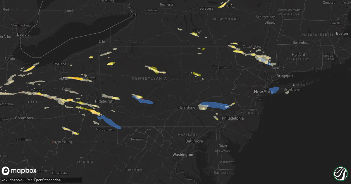
Hail Map in Pennsylvania on August 12, 2023
Get this storm
August 12 map
$229
one time, instant access
Download today. No call, no setup
Keep the $229
Bought the map and want the full workflow? Apply the entire $229 to a subscription within 7 days. None of it is wasted.
Every map, not just this one
This buys you this map. Subscription and you get every map we run, in the markets you choose from a few cities to whole states to nationwide. Plus real-time alerts the moment a storm fires.
Contact data
Name, contact info, occupancy, even credit band for addresses in the footprint. You go from where it hit to who to call.
Become the source they trust
Unlimited branding weather history reports on demand. You already have the documented answer ready for the property owner, and you are the one who showed up with it.
Property data and RoofTrace estimates
Pull up any address you have got, its value and the exact code rules for that jurisdiction, straight from One Click Code. Then RoofTrace estimates the squares, pitch, and roof value, priced the way you price.
Storm reports in Pennsylvania
Pennsylvania
| Date | Description |
|---|---|
| 08/12/20236:58 PM CDT | Trees down on brush run road and green cove road. |
| 08/12/20236:46 PM CDT | Tree down on sr-403 |
| 08/12/20236:23 PM CDT | Wires down near button rd and strickland hill rd. |
| 08/12/20236:23 PM CDT | Multiple trees down. Strickland hill rd... Springville... Pa. Time estimated by radar. |
| 08/12/20236:10 PM CDT | Numerous trees down. |
| 08/12/20236:01 PM CDT | Report of multiple down trees in the area. Time estimated based on radar. |
| 08/12/20236:00 PM CDT | Several large trees down in the north washington area |
| 08/12/20235:59 PM CDT | Report of tree down on house. Time estimated based on radar. |
| 08/12/20235:56 PM CDT | A local report indicates 1.00 inch wind near 1 ESE North Washington |
| 08/12/20235:56 PM CDT | Report of many large trees down along beaver run road. Time estimated based on radar. |
| 08/12/20235:55 PM CDT | A local report indicates 1.00 inch wind near 1 E North Washington |
| 08/12/20235:55 PM CDT | A local report indicates 1.00 inch wind near 1 NW North Washington |
| 08/12/20235:52 PM CDT | Tree limbs down. Mping report |
| 08/12/20235:48 PM CDT | Mping report |
| 08/12/20235:48 PM CDT | Photo provided |
| 08/12/20235:45 PM CDT | A local report indicates 1.25 inch wind near 1 NW Alcoa Center |
| 08/12/20235:42 PM CDT | Report and photo of large uprooted tree in west deer township. Time estimated based on radar. |
| 08/12/20235:33 PM CDT | Hail near springdale with photograph provided |
| 08/12/20235:16 PM CDT | Report of multiple trees down along bakerstown road. Time estimated based on radar. |
| 08/12/20235:15 PM CDT | Trees down from downburst wind |
| 08/12/20235:11 PM CDT | Quarter size hail reported in plumsteadville. Picture provided via social media. Time estimated via radar. |
| 08/12/20235:03 PM CDT | Numerous trees down. Roof partially blown off of a home. |
| 08/12/20235:00 PM CDT | Multiple trees down. Time estimated from radar. |
| 08/12/20235:00 PM CDT | Numerous trees down. |
| 08/12/20235:00 PM CDT | Pictures sent in of quarter-sized hail near plumstead township. Time estimated from radar. |
| 08/12/20234:44 PM CDT | Trees and wires down. Time estimated. |
| 08/12/20234:40 PM CDT | Trees and wires down. Time estimated. |
| 08/12/20234:40 PM CDT | Trees and wires down. Time estimated. |
| 08/12/20234:33 PM CDT | Ppl reports tree limbs on wires near harleysville and franconia. Time estimated from radar. |
| 08/12/20234:32 PM CDT | Trees down on wires resulting in power outages. Time estimated via radar. |
| 08/12/20234:30 PM CDT | Trees and wires down |
| 08/12/20234:15 PM CDT | Corrected location from the previous summit hill report. Numerous trees and power lines down near the intersection of pa-93 and wetzel run drive in weatherly. Pictures |
| 08/12/20234:15 PM CDT | Numerous trees and power lines down near intersection of pa-93 and wetzel run drive in weatherly. Pictures provided via social media. Time estimated via radar. |
| 08/12/20234:08 PM CDT | Public sends in picture of downed tree on hickory mill road. Time estimated from radar. |
| 08/12/20234:00 PM CDT | Report of tree down into house on marlborough springs road. Time estimated from radar. |
| 08/12/20233:51 PM CDT | Report from mping: trees uprooted or snapped; roof blown off. Update: similar reports received in nescopeck township from emergency managers. |
| 08/12/20233:46 PM CDT | Tree down on unionville wawaset road. Time estimated from radar. |
| 08/12/20233:43 PM CDT | Trees and wires down on unionville wawaset road. Time estimated from radar. |
| 08/12/20233:39 PM CDT | Trees and wires down on route 842 and cannery road in newlin. Time estimated from radar. |
| 08/12/20233:30 PM CDT | Numerous trees down. |
| 08/12/20233:29 PM CDT | Multiple trees down in and around cameron. Time estimated by radar. |
| 08/12/20233:23 PM CDT | Report of multiple trees down in southeast jefferson county. Time estimated based on radar. |
| 08/12/20233:01 PM CDT | Report from mping: quarter |
| 08/12/20232:59 PM CDT | Multiple reports from mping highlight tree limbs reported down throughout millville. |
| 08/12/20232:58 PM CDT | Two trees down on the road. Time estimated. |
| 08/12/20232:50 PM CDT | Report from mping: quarter |
| 08/12/20232:48 PM CDT | Multiple trees along with limbs down. Report from mping. |
| 08/12/20232:48 PM CDT | Time estimated. |
| 08/12/20232:46 PM CDT | Report from mping: quarter |
| 08/12/20232:40 PM CDT | Tree down in wires. Time estimated. |
| 08/12/20232:20 PM CDT | Tree and wires down. Time estimated by radar. |
| 08/12/20232:04 PM CDT | A few calls for trees and wires down in crawford co including near spartansburg. Nickel sized hail also reported in spartansburg. |
| 08/12/20231:02 PM CDT | Reports of multiple trees down near and on route 62. Time estimated by radar. |
| 08/12/202312:33 PM CDT | A few large limbs and trees downed... Some across a road. It is unknown if this tree damage was directly associated with a funnel cloud that was observed in the area or |
| 08/12/202312:00 AM CDT | Multiple trees reported down in bedminster township. Time estimated from radar. |
| 08/11/202311:50 PM CDT | A 70 foot white pine tree was uprooted near the corner of pecan drive and lansdale ave in lansdale. Photos received via social media. Time estimated from radar. |
| 08/11/202311:50 PM CDT | A 70 foot white pine tree was uprooted near the corner of pecan drive and lansdale ave in lansdale. Photos received via social media. Time estimated from radar. |
| 08/11/202311:47 PM CDT | Report from mping: 1-inch tree limbs broken; shingles blown off. Time estimated from radar. |
| 08/11/202311:46 PM CDT | Multiple trees down in west rockhill township. Time estimated from radar. |
| 08/11/202311:37 PM CDT | Tree down at hoppenville road and lumber street. Time estimated from radar. |
| 08/11/202311:37 PM CDT | Down tree in wires on gravel pike. Time estimated from radar. |
| 08/11/202311:37 PM CDT | Several trees down across geryville pike near hoppenville road. Picture sent in via facebook. Time estimated from radar. |
| 08/11/202311:35 PM CDT | Down tree in wires on west ridge pike at swamp pike. Time estimated from radar. |
| 08/11/202311:34 PM CDT | Multiple trees down across new hanover township. Time estimated from radar. |
| 08/11/202311:31 PM CDT | Trees down. Time estimated from radar. |
| 08/11/202311:30 PM CDT | Trees down in barto. Time estimated from radar. |
| 08/11/202311:29 PM CDT | Multiple trees down across douglass township. Time estimated from radar. |
| 08/11/202311:29 PM CDT | Multiple trees reported down in pottstown. Time estimated from radar. |
| 08/11/202311:28 PM CDT | Multiple trees reported down in upper pottsgrove township. Time estimated from radar. |
| 08/11/202311:28 PM CDT | Report from mping: 3-inch tree limbs broken; power poles broken. Time estimated from radar. |
| 08/11/202311:28 PM CDT | Large tree down which also brought down wires on groff road at merkle road in district township. Photo received on social media. Time estimated from radar. |
| 08/11/202311:27 PM CDT | Multiple trees reported down in stowe. Time estimated from radar. |
| 08/11/202311:20 PM CDT | Report of trees down around cumru township... Pa. |
| 08/11/202311:20 PM CDT | Report of trees down around south heidelberg township. |
| 08/11/202311:16 PM CDT | Trees and power lines down resulting in several road closures. Time estimated from radar. |
| 08/11/202311:15 PM CDT | Numerous trees and wires down in exeter township. Time estimated from radar. |
| 08/11/202311:10 PM CDT | Report from mping: trees uprooted or snapped. Time estimated from radar. |
| 08/11/202311:06 PM CDT | Trees down on holtzman road. |
| 08/11/202311:04 PM CDT | Tree down across creek road... And the tree was struck by a car. No injuries reported. |
| 08/11/202311:00 PM CDT | Report from mping: 1-inch tree limbs broken; shingles blown off. Time estimated from radar. |
| 08/11/20238:32 PM CDT | Trees down in dilliner |
| 08/11/20238:30 PM CDT | Multiple trees down along jeffrey lane. |
| 08/11/20238:30 PM CDT | Tree down on road. |
| 08/11/20238:28 PM CDT | Trees and wires down along walnut hill road. |
| 08/11/20238:28 PM CDT | Trailer collapse with occupants trapped |
| 08/11/20238:28 PM CDT | Report and photos of damage to tents set up in festival area along main street. Time estimated based on radar. |
| 08/11/20238:26 PM CDT | Trees down in the city of greensboro. |
| 08/11/20238:26 PM CDT | Mping report of trees uprooted. Time based on radar. |
| 08/11/20238:24 PM CDT | Large limbs down |
| 08/11/20238:21 PM CDT | Corrects previous tstm wnd dmg report from 2 ese ashville. Large tree down along route 36. Time estimated by radar. |
| 08/11/20238:21 PM CDT | Power lines down along mcclellandtown road and spring road. |
| 08/11/20238:18 PM CDT | Power lines down along and over route 53. Time estimated by radar. |
| 08/11/20238:16 PM CDT | Multiple trees down in the city of carmichaels |
| 08/11/20238:15 PM CDT | Multiple trees down along gallitzin rd. Time estimated by radar. |
| 08/11/20238:10 PM CDT | Trees down in rices landing. |
| 08/11/20238:01 PM CDT | Large tree down along route 36. Time estimated by radar. |
| 08/11/20238:00 PM CDT | Report of several trees dow near bethlehem-center elementary school. Time estimated based on radar. |
| 08/11/20237:54 PM CDT | Multiple trees down reported in cambria twp. Time estimated by radar. |
| 08/11/20237:52 PM CDT | Trees down in the city of wind ridge. |
| 08/11/20237:40 PM CDT | Tree limbs down. Mping report |
| 08/11/20237:40 PM CDT | Barn destroyed along brush run rd and trees down along lone pine rd |
| 08/11/20237:35 PM CDT | Trees down at 27 mile marker on i-79. Time estimated. |
| 08/11/20237:34 PM CDT | Trees down on laurel run road. |
| 08/11/20237:32 PM CDT | Large branches down. Time estimated. |
| 08/11/20237:24 PM CDT | A township shed and outbuilding were destroyed along prosperity pike. Damage was coincident with a continuing tornado debris signature. |
| 08/11/20237:22 PM CDT | Barn levelled and trees down. Damage coincident with tornado couplet with debris signature. |
| 08/11/20237:18 PM CDT | A local report indicates 1.75 inch wind near 1 NNE Lagonda |
| 08/11/20237:15 PM CDT | Mping report |
| 08/11/20237:14 PM CDT | Hailstone fell on hawthorn road. |
| 08/11/20237:13 PM CDT | Roof ripped off home on cracraft road. |
| 08/11/20237:12 PM CDT | Multiple photos of measured 2 inch hail in the claysville area |
| 08/11/20237:11 PM CDT | Multiple trees and wires down in a concentrated swath along valley view rd. Likely start of tornado just preceding the development of a prolonged tornado debris signatu |
| 08/11/20237:08 PM CDT | A local report indicates 2.00 inch wind near 1 SSE Taylorstown |
| 08/11/20237:08 PM CDT | Photo provided |
| 08/11/20237:00 PM CDT | A local report indicates 1.25 inch wind near 3 NW Claysville |
All States Impacted by Hail Map on August 12, 2023
Cities Impacted by Hail Map on August 12, 2023
- Columbus, IN
- Kenton, OH
- Bellevue, OH
- Castalia, OH
- Sandusky, OH
- Huron, OH
- Morral, OH
- Marion, OH
- Linesville, PA
- Conneautville, PA
- Bowling Green, KY
- Nashville, IN
- Gravel Switch, KY
- Bradfordsville, KY
- Whitewater, MO
- Troy, TN
- Union City, TN
- Rives, TN
- Martinsville, IN
- Mooresville, IN
- Bronston, KY
- Ridgely, TN
- Ada, OH
- Kenton, TN
- Belton, KY
- Drakesboro, KY
- Saint Charles, KY
- Nortonville, KY
- Scott City, MO
- Chaffee, MO
- Oran, MO
- Benton, MO
- Fulton, KY
- South Fulton, TN
- Seymour, IN
- Republic, OH
- Edmonton, KY
- Knob Lick, KY
- McKenzie, TN
- Alger, OH
- Campbellsburg, IN
- White Plains, KY
- Lewisburg, KY
- Rochester, KY
- Morgantown, KY
- Murray, KY
- Burnside, KY
- Paducah, KY
- West Paducah, KY
- Williamsburg, KY
- Corbin, KY
- Washington, IN
- Cannelburg, IN
- Loogootee, IN
- Montgomery, IN
- Jasper, IN
- Otwell, IN
- Orleans, IN
- Salem, IN
- Palmyra, TN
- East Prairie, MO
- Bertrand, MO
- Dover, TN
- Indian Mound, TN
- Cedar Grove, TN
- Huntingdon, TN
- Stewart, TN
- Big Sandy, TN
- Chanute, KS
- Benedict, KS
- Yates Center, KS
- Buffalo, KS
- Dukedom, TN
- Morgantown, IN
- Nineveh, IN
- Dawson Springs, KY
- Princeton, KY
- Lebanon, KY
- Fort Scott, KS
- Redfield, KS
- Wildersville, TN
- Grand Rivers, KY
- Smithland, KY
- Hornbeak, TN
- Louisville, KY
- Martin, TN
- Hickman, KY
- New Madrid, MO
- Clinton, KY
- Charleston, MO
- Brookport, IL
- Bethel Springs, TN
- Hornsby, TN
- Greenfield, TN
- Rutherford, TN
- Waverly, TN
- Whitley City, KY
- Parkers Lake, KY
- McIntire, IA
- Lima, OH
- Science Hill, KY
- Liberty, KY
- Bethelridge, KY
- Windsor, KY
- Greensburg, KY
- Vanlue, OH
- Findlay, OH
- Carey, OH
- Alvada, OH
- Mayfield, KY
- Wingo, KY
- Dola, OH
- Ledbetter, KY
- Fostoria, OH
- Tennessee Ridge, TN
- Trafalgar, IN
- Monticello, KY
- Fredonia, KY
- Campbellsville, KY
- Glasgow, KY
- Hazel, KY
- Buchanan, TN
- New Concord, KY
- Shepherdsville, KY
- Mount Washington, KY
- Sikeston, MO
- Matthews, MO
- Trezevant, TN
- Harrod, OH
- Bluffton, OH
- Beechmont, KY
- Beech Creek, KY
- Greenville, KY
- Browder, KY
- Palmyra, IN
- Bradford, TN
- Atwood, TN
- Cumberland City, TN
- Yuma, TN
- Roachdale, IN
- Attica, IN
- Obion, TN
- Freetown, IN
- Franklin, IN
- Brooklyn, IN
- Bargersville, IN
- Arcadia, OH
- New Albany, IN
- Lanesville, IN
- Taylorsville, KY
- Elizabeth, IN
- Georgetown, IN
- Arlington, OH
- Mount Blanchard, OH
- Cairo, IL
- Roundhill, KY
- Brownsville, KY
- Lexington, TN
- Oakland, KY
- Beaverdam, OH
- Columbus Grove, OH
- Tiffin, OH
- Green Springs, OH
- Henderson, TN
- Bell City, MO
- New Bloomington, OH
- Jenera, OH
- Waynesfield, OH
- La Rue, OH
- Belle Center, OH
- Bellville, OH
- Butler, OH
- Perrysville, OH
- Loudonville, OH
- Knoxville, TN
- Newfield, NY
- Ithaca, NY
- Spencer, NY
- Van Etten, NY
- Seymour, TN
- Franklin, PA
- Cooperstown, PA
- Oil City, PA
- Titusville, PA
- Pleasantville, PA
- Killbuck, OH
- Millersburg, OH
- Glenmont, OH
- Big Prairie, OH
- Kent, OH
- Ravenna, OH
- Rootstown, OH
- Nemo, SD
- Deadwood, SD
- Rapid City, SD
- Hill City, SD
- Black Hawk, SD
- Diamond, OH
- Newton Falls, OH
- Lake Milton, OH
- North Jackson, OH
- Berlin Center, OH
- New Philadelphia, OH
- Dover, OH
- Youngstown, OH
- Canfield, OH
- Apache, OK
- Eldorado, OK
- Mount Juliet, TN
- Lebanon, TN
- Murfreesboro, TN
- Lascassas, TN
- Watertown, TN
- Milton, TN
- Brush Creek, TN
- Hickman, TN
- Alexandria, TN
- Waldron, KS
- Liberty, TN
- Auburntown, TN
- Readyville, TN
- Woodbury, TN
- Bradyville, TN
- Dowelltown, TN
- Lancaster, TN
- Manchester, TN
- Smithville, TN
- Morrison, TN
- Mcminnville, TN
- Christiana, TN
- Baxter, TN
- Sparta, TN
- Silver Point, TN
- Buffalo Valley, TN
- Dennison, OH
- Sherrodsville, OH
- Bowerston, OH
- Emporium, PA
- Driftwood, PA
- Sinnamahoning, PA
- Westport, PA
- Pottersdale, PA
- Coatesville, PA
- Kennett Square, PA
- West Chester, PA
- Parrottsville, TN
- Greeneville, TN
- Marshall, NC
- Campbell, OH
- Struthers, OH
- Lowellville, OH
- Altus, OK
- Headrick, OK
- Keystone, SD
- Elmer, OK
- Elgin, OK
- Mills River, NC
- Horse Shoe, NC
- Hendersonville, NC
- Hermosa, SD
- Caputa, SD
- Rock Island, TN
- Walling, TN
- Quebeck, TN
- Spencer, TN
- Doyle, TN
- Fletcher, OK
- Hankins, NY
- Long Eddy, NY
- Roscoe, NY
- Fremont Center, NY
- North Branch, NY
- Jeffersonville, NY
- Livingston Manor, NY
- Liberty, NY
- Walton, NY
- East Branch, NY
- Downsville, NY
- Hamden, NY
- Delancey, NY
- Jewett, OH
- Amsterdam, OH
- Hopedale, OH
- Bloomingdale, OH
- Steubenville, OH
- Richmond, OH
- Carrollton, GA
- Cookeville, TN
- Parksville, NY
- Rome, PA
- Warren Center, PA
- Whitesburg, GA
- Odell, TX
- Olustee, OK
- Vernon, TX
- Little Meadows, PA
- Pipersville, PA
- Doylestown, PA
- New Hope, PA
- Scenic, SD
- Atlanta, GA
- Burgettstown, PA
- Avella, PA
- McDonald, PA
- Hickory, PA
- Cadiz, OH
- Apollo, PA
- New Kensington, PA
- Pine Ridge, SD
- Spearfish, SD
- Electra, TX
- Grandfield, OK
- Adena, OH
- Dillonvale, OH
- Avonmore, PA
- Saltsburg, PA
- Sterling, NY
- Hannibal, NY
- Oswego, NY
- Oneida, NY
- Verona, NY
- Vernon, NY
- Rome, NY
- Oriskany, NY
- Smithfield, OH
- Rayland, OH
- Iowa Park, TX
- Custer, SD
- Sundance, WY
- Napanoch, NY
- Ellenville, NY
- Kerhonkson, NY
- Wawarsing, NY
- Athens, OH
- Beech Bottom, WV
- Wellsburg, WV
- Bethany, WV
- Wheeling, WV
- Canute, OK
- Foss, OK
- Dill City, OK
- Cordell, OK
- Andover, OH
- Pierpont, OH
- Redfield, NY
- Camden, NY
- Trumansburg, NY
- Hulett, WY
- Anthony, KS
- Potts Camp, MS
- Roanoke, AL
- Carmen, OK
- Sunbright, TN
- Robbins, TN
- Hartley, TX
- Arden, NC
- Etowah, NC
- Fletcher, NC
- Lawton, OK
- Aberdeen, MS
- Williamstown, NY
- Clayton, NM
- Moody, AL
- Odenville, AL
- Anadarko, OK
- Cement, OK
- Altmar, NY
- Burton, OH
- Newbury, OH
- Fremont, OH
- Five Points, AL
- Lanett, AL
- Rouseville, PA
- Frederick, OK
- Snyder, OK
- Tipton, OK
- Fort Sill, OK
- Buena Vista, GA
- Monroeville, OH
- Berkshire, NY
- Newark Valley, NY
- Piedmont, AL
- Headland, AL
- Marlow, OK
- Pratt, KS
- Turon, KS
- Union City, PA
- Centerville, PA
- Saegertown, PA
- Spartansburg, PA
- Cambridge Springs, PA
- Gould, OK
- Duke, OK
- Ozark, AL
- Clyde, OH
- Baker, FL
- Jacksonville, AL
- Aragon, GA
- North Port, FL
- Port Charlotte, FL
- Franklin, GA
- Rawson, OH
- Colliers, WV
- Angel Fire, NM
- Vernon, AL
- Millport, AL
- Kennedy, AL
- Eglin Afb, FL
- Valparaiso, FL
- Niceville, FL
- Hughesville, PA
- Cyril, OK
- Lakeville, OH
- Lucas, OH
- Mansfield, OH
- New Washington, OH
- Plymouth, OH
- Shelby, OH
- Shiloh, OH
- Nova, OH
- Bloomville, OH
- Ashland, OH
- Greenwich, OH
- Sullivan, OH
- Tiro, OH
- Alva, OK
- Benezett, PA
- Toccoa, GA
- Bergholz, OH
- Carrollton, OH
- Snellville, GA
- Lithonia, GA
- Dalhart, TX
- East Sparta, OH
- Canton, OH
- Lagrange, GA
- Amarillo, TX
- Lancing, TN
- Girard, OH
- Hubbard, OH
- Sugarcreek, OH
- Munroe Falls, OH
- Hillsville, PA
- Cuyahoga Falls, OH
- Akron, OH
- Edinburg, PA
- Deerfield, OH
- Tallmadge, OH
- Atwater, OH
- West Point, MS
- Woodland, AL
- Renovo, PA
- Saint Marys, PA
- Yuma, CO
- Brooktondale, NY
- Gibsonia, PA
- Allison Park, PA
- Glenshaw, PA
- Cheswick, PA
- Pittsburgh, PA
- Indianola, PA
- Fort Cobb, OK
- Balmorhea, TX
- Scottsboro, AL
- Waynesburg, OH
- Equinunk, PA
- Scio, OH
- Alpine, NY
- Mexico, NY
- Pulaski, NY
- Muse, PA
- Canonsburg, PA
- Houston, PA
- Pickens, SC
- Sunset, SC
- Lead, SD
- Dayton, TN
- Bucyrus, OH
- Dundee, NY
- Hammondsport, NY
- Waverly, AL
- Berwick, PA
- Rush Springs, OK
- Buchanan, GA
- Cedartown, GA
- Rockmart, GA
- Attica, KS
- Dunmor, KY
- Greencastle, IN
- Dadeville, AL
- Newcastle, WY
- Altoona, AL
- Oneonta, AL
- Chatsworth, GA
- Springville, TN
- Novelty, OH
- Fayette, AL
- Ninnekah, OK
- Wedowee, AL
- Pritchett, CO
- Williamsport, IN
- Downingtown, PA
- Auburn, AL
- Olivehill, TN
- Blountsville, AL
- Carnesville, GA
- Warsaw, OH
- Heflin, AL
- Sedan, NM
- Conyers, GA
- Oxford, GA
- Sarasota, FL
- Holly Springs, MS
- Fruithurst, AL
- Columbus, PA
- Corry, PA
- Wartburg, TN
- Westville, FL
- Floyds Knobs, IN
- Schwenksville, PA
- Evergreen, AL
- Eastanollee, GA
- Martin, GA
- Sevierville, TN
- Walland, TN
- Millville, PA
- Benton, PA
- Orangeville, PA
- Unityville, PA
- Harwick, PA
- Creighton, PA
- Springdale, PA
- Tarentum, PA
- Chickasha, OK
- Wadley, AL
- Highlands, NC
- Franklin, NC
- Galion, OH
- Elba, AL
- Stockbridge, GA
- Midland City, AL
- Tippecanoe, OH
- Port Washington, OH
- Newcomerstown, OH
- Dalton, GA
- Rocky Face, GA
- Tunnel Hill, GA
- Powell, TN
- Ringgold, GA
- Minerva, OH
- Mechanicstown, OH
- Malvern, OH
- Cleveland, TN
- Apison, TN
- Hanceville, AL
- Cullman, AL
- Holly Pond, AL
- Abbeville, AL
- Cohutta, GA
- Sulligent, AL
- Walhonding, OH
- Frazeysburg, OH
- Nevada, OH
- Mount Gilead, OH
- Baltic, OH
- Caledonia, OH
- Edison, OH
- Faxon, OK
- Newville, AL
- Guysville, OH
- Claysville, PA
- West Alexander, PA
- Kyle, SD
- Kadoka, SD
- Belvidere, SD
- Long Valley, SD
- Washington, PA
- Prosperity, PA
- Amity, PA
- Scenery Hill, PA
- New Paltz, NY
- Gardiner, NY
- Wallkill, NY
- Modena, NY
- Highland, NY
- Marlboro, NY
- Newburgh, NY
- Clintondale, NY
- Milton, NY
- Wappingers Falls, NY
- Beacon, NY
- Cold Spring, NY
- Chelsea, NY
- Poughkeepsie, NY
- Fishkill, NY
- Hopewell Junction, NY
- Carmel, NY
- Stormville, NY
- Holmes, NY
- New Matamoras, OH
- Friendly, WV
- Sistersville, WV
- Fairburn, SD
- White River, SD
- Carrolltown, PA
- Ebensburg, PA
- Loretto, PA
- Gallitzin, PA
- Ashville, PA
- Duncansville, PA
- Patton, PA
- Elmora, PA
- Chest Springs, PA
- Middlebourne, WV
- Sycamore, PA
- Waynesburg, PA
- Jefferson, PA
- Fredericktown, PA
- Clarksville, PA
- Marianna, PA
- Brownsville, PA
- La Belle, PA
- Vestaburg, PA
- East Millsboro, PA
- Millsboro, PA
- Mather, PA
- Carmichaels, PA
- Crucible, PA
- Rices Landing, PA
- Adah, PA
- Nemacolin, PA
- Masontown, PA
- Ronco, PA
- Denbo, PA
- McClellandtown, PA
- Uledi, PA
- Uniontown, PA
- New Salem, PA
- Republic, PA
- Fairbank, PA
- Merrittstown, PA
- Cardale, PA
- Smithfield, PA
- Penn Run, PA
- Northern Cambria, PA
- Nicktown, PA
- Strongstown, PA
- Colver, PA
- Lilly, PA
- Cresson, PA
- Portage, PA
- Cassandra, PA
- Altoona, PA
- Hollidaysburg, PA
- Sturgis, SD
- Vale, SD
- Fairchance, PA
- Farmington, PA
- Hopwood, PA
- Brownfield, PA
- Newry, PA
- Garden City, KS
- Ingalls, KS
- Pierceville, KS
- Sublette, KS
- Ulysses, KS
- Porcupine, SD
- New Underwood, SD
- Bruceton Mills, WV
- Gibbon Glade, PA
- Friendsville, MD
- Markleysburg, PA
- Martinsburg, PA
- Williamsburg, PA
- Hesston, PA
- James Creek, PA
- Accident, MD
- Lairdsville, PA
- Muncy, PA
- Stillwater, PA
- Manderson, SD
- Batesland, SD
- Allen, SD
- Martin, SD
- Wounded Knee, SD
- Wood Lake, NE
- Johnstown, NE
- Ainsworth, NE
- Tuthill, SD
- Moorcroft, WY
- Lafayette, AL
- Oswegatchie, NY
- Harrisville, NY
- Lindsay, OK
- Mannsville, NY
- Grahamsville, NY
- Carter, OK
- Granite, OK
- Paducah, TX
- Fountainville, PA
- Perkasie, PA
- Hilltown, PA
- Chalfont, PA
- Hatfield, PA
- Wanblee, SD
- Pike Road, AL
- Rockford, AL
- Union Center, SD
- Valentine, NE
- Towanda, PA
- Wysox, PA
- Morris, GA
- Georgetown, GA
- Groom, TX
- Pampa, TX
- Edgemont, SD
- Lacona, NY
- Leesville, OH
- Graysville, OH
- Fishs Eddy, NY
- Hancock, NY
- Quanah, TX
- Sentinel, OK
- Uhrichsville, OH
- Gnadenhutten, OH
- Pendleton, SC
- Anderson, SC
- Stone Ridge, NY
- Norris, SD
- Parmelee, SD
- Petersburg, TX
- East Rochester, OH
- East Canton, OH
- Kensington, OH
- Alford, FL
- Cottondale, FL
- Chipley, FL
- Columbus, MS
- Cold Brook, NY
- Hoffmeister, NY
- Defuniak Springs, FL
- Mission, SD
- Talladega, AL
- Troy, AL
- Fitzpatrick, AL
- Prairie, MS
- Freeport, OH
- Sunray, TX
- Valley Grove, WV
- West Liberty, WV
- Macon, GA
- Niles, OH
- McDonald, OH
- Dawson, GA
- Plains, GA
- Union Springs, AL
- Banks, AL
- Fallsburg, NY
- Greenfield Park, NY
- Swan Lake, NY
- Callicoon, NY
- Youngsville, NY
- Hurleyville, NY
- Woodbourne, NY
- Loch Sheldrake, NY
- White Sulphur Springs, NY
- Ferndale, NY
- Woodridge, NY
- Midway, AL
- Cottekill, NY
- Accord, NY
- Olivebridge, NY
- Kingston, NY
- Salineville, OH
- Hammondsville, OH
- Sandy Creek, NY
- Gadsden, AL
- Walden, NY
- Smithton, PA
- Mount Pleasant, PA
- Ruffs Dale, PA
- Tarrs, PA
- Alverton, PA
- Harleysville, PA
- Souderton, PA
- Parrott, GA
- Pleasant Valley, NY
- Lagrangeville, NY
- Saluda, NC
- Flat Rock, NC
- Royston, GA
- Dumas, TX
- Trussville, AL
- Wood, SD
- Slocomb, AL
- Hartford, AL
- Hyde Park, NY
- Cedar Vale, KS
- Arnoldsville, GA
- Winterville, GA
- Honea Path, SC
- Belton, SC
- Indiahoma, OK
- Crestview, FL
- Titus, AL
- Equality, AL
- Lock Haven, PA
- Weogufka, AL
- Sylacauga, AL
- Elberton, GA
- Coolville, OH
- Gruver, TX
- Butler, OK
- Clinton, OK
- Remsen, NY
- Pelham, AL
- Alabaster, AL
- Columbiana, AL
- Pittsview, AL
- New Fairfield, CT
- Brewster, NY
- Patterson, NY
- Pawling, NY
- Masterson, TX
- Eufaula, AL
- Smithville, WV
- Macfarlan, WV
- Petroleum, WV
- Harrisville, WV
- Athens, PA
- Sayre, PA
- Ulster, PA
- Dexter City, OH
- Macksburg, OH
- Caldwell, OH
- Lower Salem, OH
- Alverda, PA
- Mentcle, PA
- Hamilton, MS
- Texline, TX
- Saint Clairsville, OH
- Dothan, AL
- Newton, AL
- Felt, OK
- Holt, FL
- Wellington, AL
- Glenmoore, PA
- Sherrill, NY
- Mineral Wells, WV
- Parkersburg, WV
- Washington, WV
- Carnegie, OK
- Stone Creek, OH
- Warren, OH
- Guymon, OK
- Goodwell, OK
- Red Creek, NY
- Wexford, PA
- Verona, PA
- Clarksburg, PA
- Waterford, MS
- Jeffersonville, GA
- Stratford, TX
- White Deer, TX
- Adams, NY
- Lorraine, NY
- New Castle, PA
- Marianna, FL
- Ramer, AL
- Lumpkin, GA
- Omaha, GA
- Spraggs, PA
- Milton, FL
- Jay, FL
- Mount Clare, WV
- Lost Creek, WV
- Medicine Park, OK
- Cache, OK
- Springville, AL
- Wetumpka, AL
- Wingett Run, OH
- Benwood, WV
- Bellaire, OH
- Bridgeport, OH
- Brownsboro, AL
- Huntsville, AL
- West Shokan, NY
- Heilwood, PA
- Clymer, PA
- Lone Wolf, OK
- Central, SC
- Ulster Park, NY
- Loveland, OK
- Somerset, KY
- Hardaway, AL
- Tuskegee, AL
- Holbrook, PA
- Mingo Junction, OH
- Follansbee, WV
- Midvale, OH
- Strabane, PA
- Fresno, OH
- Westland, PA
- Campbellton, FL
- Graceville, FL
- Merriman, NE
- Cody, NE
- Long Pine, NE
- Bassett, NE
- Collegeville, PA
- Skippack, PA
- Blue Bell, PA
- Norristown, PA
- Lansdale, PA
- Telford, PA
- Green Lane, PA
- Perkiomenville, PA
- Sellersville, PA
- Bechtelsville, PA
- Fleetwood, PA
- Boyertown, PA
- Reading, PA
- Gilbertsville, PA
- Frederick, PA
- Oley, PA
- Pennsburg, PA
- Barto, PA
- Temple, PA
- Leesport, PA
- Birdsboro, PA
- Pottstown, PA
- Douglassville, PA
- Mohnton, PA
- Zieglerville, PA
- Royersford, PA
- Bernville, PA
- Mohrsville, PA
- Robesonia, PA
- Richland, PA
- Womelsdorf, PA
- Wernersville, PA
- Myerstown, PA
- Reinholds, PA
- Lebanon, PA
- Newmanstown, PA
- Denver, PA
- Hot Springs, SD
- Lance Creek, WY
- Oelrichs, SD
- Smithwick, SD
- Glen Head, NY
- Roslyn Heights, NY
- Port Washington, NY
- Mineola, NY
- Carle Place, NY
- Manhasset, NY
- Old Westbury, NY
- Roslyn, NY
- East Norwich, NY
- Westbury, NY
- Albertson, NY
- Greenvale, NY
- Williston Park, NY
- Great Neck, NY
- Little Neck, NY
- Oyster Bay, NY
- Bayside, NY
- Glenwood Landing, NY
- New Hyde Park, NY
- Glen Oaks, NY
- Oakland Gardens, NY
- Bellerose, NY
- Floral Park, NY
- Garden City, NY
- Malverne, NY
- Elmont, NY
- Rockville Centre, NY
- Franklin Square, NY
- West Hempstead, NY
- Lynbrook, NY
- Hempstead, NY
- Valley Stream, NY
- Uniondale, NY
- Roosevelt, NY
- Freeport, NY
- Baldwin, NY
- East Meadow, NY
- Merrick, NY
- Bellmore, NY
- Jericho, NY
- Syosset, NY
- Wantagh, NY
- Bethpage, NY
- Levittown, NY
- Hicksville, NY
- Plainview, NY
- Old Bethpage, NY
- Woodbury, NY
- Melville, NY
- Huntington, NY
- Cold Spring Harbor, NY
- Hays, KS
- Spavinaw, OK
- Mills, NE
- Springview, NE
- Eucha, OK
- Sparks, NE
- New Cambria, KS
- Newport, NE
- Winner, SD
- Hoskins, NE
- Winside, NE
- Salina, KS
- Ramona, OK
- Talala, OK
- Stuart, NE
- Clearwater, NE
- Bloomingburg, NY
- Pine Bush, NY
- Lititz, PA
- Ephrata, PA
- Stevens, PA
- Pekin, IN
- Kilgore, NE
- Saint Francis, SD
- Schaefferstown, PA
- Manheim, PA
- Walker, WV
- Carroll, NE
- Strang, OK
- Nenzel, NE
- Walker, KS
- Victoria, KS
- Gorham, KS
- Fritch, TX
- Wayne, NE
- Atkinson, NE
- Lincoln, NE
- Wilson, KS
- Claflin, KS
- Stanton, NE
- Norfolk, NE
- Hoisington, KS
- Hindsville, AR
- Rogers, AR
- Sayville, NY
- Ocean Beach, NY
- Great River, NY
- Utica, NY
- Westmoreland, NY
- Green Forest, AR
- Alpena, AR
- Fayetteville, AR
- Lambertville, NJ
- Thorndale, PA
- Huntsville, AR
- Vinita, OK
- Council Grove, KS
- Allen, KS
- Ava, NY
- Lee Center, NY
- Oneill, NE
- Inman, NE
- Page, NE
- Ewing, NE
- Orchard, NE
- Royal, NE
- Poughquag, NY
- Durhamville, NY
- Berryville, AR
- Lusk, WY
- Boonville, NY
- Kenton, OK
- Springdale, AR
- Southampton, NY
- Water Mill, NY
- Ringoes, NJ
- Jay, OK
- Big Cabin, OK
- Pryor, OK
- Salina, OK
- Stittville, NY
- Holland Patent, NY
- Adair, OK
- Lowell, AR
- Oologah, OK
- Chelsea, OK
- Ridge, NY


