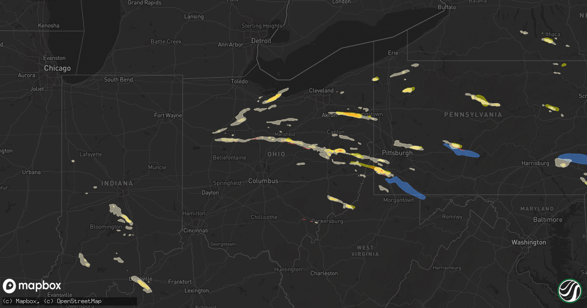
Hail Map in Ohio on August 12, 2023
Get this storm
August 12 map
$229
one time, instant access
Download today. No call, no setup
Keep the $229
Bought the map and want the full workflow? Apply the entire $229 to a subscription within 7 days. None of it is wasted.
Every map, not just this one
This buys you this map. Subscription and you get every map we run, in the markets you choose from a few cities to whole states to nationwide. Plus real-time alerts the moment a storm fires.
Contact data
Name, contact info, occupancy, even credit band for addresses in the footprint. You go from where it hit to who to call.
Become the source they trust
Unlimited branding weather history reports on demand. You already have the documented answer ready for the property owner, and you are the one who showed up with it.
Property data and RoofTrace estimates
Pull up any address you have got, its value and the exact code rules for that jurisdiction, straight from One Click Code. Then RoofTrace estimates the squares, pitch, and roof value, priced the way you price.
Storm reports in Ohio
Ohio
| Date | Description |
|---|---|
| 08/12/20236:35 PM CDT | Storm spotter called saying a tornado is on the ground heading east on highway 33. Says he has video confirmation. |
| 08/12/20236:33 PM CDT | Corrects previous tornado report from 1 ssw athens. An ef1 tornado with maximum winds up to 100 mph tracked 2.3 miles across athens county touching down near angel ridg |
| 08/12/20236:10 PM CDT | Trees down along river rd and river hill rd sw |
| 08/12/20236:09 PM CDT | Report of broken tree branches 5 inches thick. Time estimated based on radar. |
| 08/12/20236:05 PM CDT | Trees down on millers ridge rd sw |
| 08/12/20236:05 PM CDT | Trees down along i-77 |
| 08/12/20236:04 PM CDT | Trees down on stone creek rd... Including on a vehicle with two trapped occupants |
| 08/12/20236:03 PM CDT | Trees down along i-77 |
| 08/12/20235:57 PM CDT | Trees down along crooked run rd and funk rd |
| 08/12/20235:50 PM CDT | Trees down along dover rd |
| 08/12/20235:40 PM CDT | Tree downed across road near state route 515 and county road 168. Time estimated via radar. |
| 08/12/20235:18 PM CDT | Tree downed across ohio route 39. Time estimated via radar. |
| 08/12/20234:52 PM CDT | A few roads closed between perrysville and loudonville due to downed trees and wires. Time estimated via radar. |
| 08/12/20234:50 PM CDT | Report from mping: quarter |
| 08/12/20234:24 PM CDT | Tree down on trappan-scio road and hanover ridge road. |
| 08/12/20234:12 PM CDT | Trees down along bramble rd and dyewood rd |
| 08/12/20234:07 PM CDT | Trees and power lines down across highway 212 |
| 08/12/20234:05 PM CDT | Several trees were blown down blocking roads in poland. Video from yng tv media. Time was estimated by radar. |
| 08/12/20234:04 PM CDT | Trees down in vicinity of leesville to sherrodsville |
| 08/12/20233:58 PM CDT | A local report indicates 1.75 inch wind near Sherrodsville |
| 08/12/20233:52 PM CDT | Tree reported on house in austintown. No cross street given. Time estimated by radar. |
| 08/12/20233:45 PM CDT | Wires down at the intersection of baltzey road southeast and ridge road. Time estimated. |
| 08/12/20233:42 PM CDT | Wires down on state route 800. Time estimated. |
| 08/12/20233:30 PM CDT | Picture from social media of half dollar size hail. |
| 08/12/20233:30 PM CDT | Trees and wires down on delaware drive se. Time estimated. |
| 08/12/20233:30 PM CDT | Reported via social media. |
| 08/12/20233:28 PM CDT | A local report indicates 1.00 inch wind near 1 W Dover |
| 08/12/20233:25 PM CDT | Video on social media of ping pong to golf ball size hail near lake milton. |
| 08/12/20233:24 PM CDT | County ema reported roof damage to a historical building and down powerlines in the palmyra township area. Storm damage was possibly caused by brief tornado. |
| 08/12/20233:21 PM CDT | A few trees and power lines downed in russel township... Munson... And burton. |
| 08/12/20233:19 PM CDT | Tree on wires on township road 401. Time estimated via radar. |
| 08/12/20232:20 PM CDT | An nws storm survey confirmed a weak... Intermittent ef-0 tornado with a maximum estimated wind speed of 70 mph occurred in holmes county on august 12... 2023. The torn |
| 08/12/20231:53 PM CDT | A tree limb poked through the roof and ceiling of a home and extended into a bedroom. The photo was shared on social media by a broadcast meteorologist. |
| 08/12/20231:44 PM CDT | Spotter reported a brief touchdown near the intersection of i-71 and highway 13. Tornado touchdown just northeast of walmart away from structures and in the wood. No da |
| 08/12/20231:27 PM CDT | A couple of trees reported downed near mansfield-washington rd. Time estimated via radar. |
| 08/12/20231:25 PM CDT | Large tree downed across kings corners road e. Time estimated via radar. |
| 08/12/20231:25 PM CDT | Large tree downed across kings corners road e. Time estimated via radar. |
| 08/12/20231:23 PM CDT | Report from mping: quarter |
| 08/12/202312:59 PM CDT | Two trees reported downed on roads near polk twp. One fell across ohio 19 and one fell along shearer road. |
| 08/12/202312:45 PM CDT | Power lines and trees down on bogart road. Storm damage picture from social media. |
| 08/12/202312:35 PM CDT | Spotter reported golf ball sized hail and 80 mph winds near the intersection of route 2 and route 4. He also reported windows blown out and tv antenna blown down at his |
| 08/12/202312:35 PM CDT | Golf ball size hail reported by trained weather spotter. |
| 08/12/202312:35 PM CDT | Ema reporting several power lines and power poles blown down. A couple poles were reported on cars off highway 4. |
| 08/12/202312:35 PM CDT | Trees and power lines down countywide. Time estimated from radar. |
| 08/12/202312:12 PM CDT | Storm spotter reported damage to a barn... Tree down... And debris scattered in field. Possible tornado may have caused the damage. |
| 08/12/202312:08 PM CDT | A brief tornado touched down just south of the intersection of state route 309 and dry lane road n. Part of the roof was torn off of an outbuilding with some debris thr |
| 08/12/202312:00 PM CDT | Several trees down in bascom and hopewell township. Time estimated from radar. |
| 08/12/202311:50 AM CDT | Numerous trees down in and around cleveland heights. Time estimated from radar. |
| 08/12/202311:46 AM CDT | Tornado reported on the ground in the city of kenton. |
| 08/12/202311:46 AM CDT | Ef1 tornado confirmed in hardin county... Ohio. Damage to trees and structures on the south side of the city of kenton. Estimated winds of 90 mph. |
| 08/12/202311:32 AM CDT | Large tree fell into the back of a house in findlay and took down power lines. Time estimated from radar. |
| 08/11/20237:11 PM CDT | A couple of trees down along state route 564 and low gap road. |
| 08/11/20237:10 PM CDT | Report of trees and power lines down. Time estimated based on radar. |
| 08/11/20237:06 PM CDT | A number of trees and power lines down near kagg hill road and maynard road. |
| 08/11/20237:06 PM CDT | Report of numerous trees and power lines down. Time estimated based on radar. |
| 08/11/20237:03 PM CDT | Report of numerous trees down and blocking kagg hill road. Time estimated based on radar. |
| 08/11/20237:03 PM CDT | Report of numerous trees snapped or uprooted in the hidden springs subdivision with a few landing on homes. Time estimated based on radar. |
| 08/11/20237:01 PM CDT | Report of trees and power lines down. Time estimated based on radar. |
All States Impacted by Hail Map on August 12, 2023
Cities Impacted by Hail Map on August 12, 2023
- Columbus, IN
- Kenton, OH
- Bellevue, OH
- Castalia, OH
- Sandusky, OH
- Huron, OH
- Morral, OH
- Marion, OH
- Linesville, PA
- Conneautville, PA
- Bowling Green, KY
- Nashville, IN
- Gravel Switch, KY
- Bradfordsville, KY
- Whitewater, MO
- Troy, TN
- Union City, TN
- Rives, TN
- Martinsville, IN
- Mooresville, IN
- Bronston, KY
- Ridgely, TN
- Ada, OH
- Kenton, TN
- Belton, KY
- Drakesboro, KY
- Saint Charles, KY
- Nortonville, KY
- Scott City, MO
- Chaffee, MO
- Oran, MO
- Benton, MO
- Fulton, KY
- South Fulton, TN
- Seymour, IN
- Republic, OH
- Edmonton, KY
- Knob Lick, KY
- McKenzie, TN
- Alger, OH
- Campbellsburg, IN
- White Plains, KY
- Lewisburg, KY
- Rochester, KY
- Morgantown, KY
- Murray, KY
- Burnside, KY
- Paducah, KY
- West Paducah, KY
- Williamsburg, KY
- Corbin, KY
- Washington, IN
- Cannelburg, IN
- Loogootee, IN
- Montgomery, IN
- Jasper, IN
- Otwell, IN
- Orleans, IN
- Salem, IN
- Palmyra, TN
- East Prairie, MO
- Bertrand, MO
- Dover, TN
- Indian Mound, TN
- Cedar Grove, TN
- Huntingdon, TN
- Stewart, TN
- Big Sandy, TN
- Chanute, KS
- Benedict, KS
- Yates Center, KS
- Buffalo, KS
- Dukedom, TN
- Morgantown, IN
- Nineveh, IN
- Dawson Springs, KY
- Princeton, KY
- Lebanon, KY
- Fort Scott, KS
- Redfield, KS
- Wildersville, TN
- Grand Rivers, KY
- Smithland, KY
- Hornbeak, TN
- Louisville, KY
- Martin, TN
- Hickman, KY
- New Madrid, MO
- Clinton, KY
- Charleston, MO
- Brookport, IL
- Bethel Springs, TN
- Hornsby, TN
- Greenfield, TN
- Rutherford, TN
- Waverly, TN
- Whitley City, KY
- Parkers Lake, KY
- McIntire, IA
- Lima, OH
- Science Hill, KY
- Liberty, KY
- Bethelridge, KY
- Windsor, KY
- Greensburg, KY
- Vanlue, OH
- Findlay, OH
- Carey, OH
- Alvada, OH
- Mayfield, KY
- Wingo, KY
- Dola, OH
- Ledbetter, KY
- Fostoria, OH
- Tennessee Ridge, TN
- Trafalgar, IN
- Monticello, KY
- Fredonia, KY
- Campbellsville, KY
- Glasgow, KY
- Hazel, KY
- Buchanan, TN
- New Concord, KY
- Shepherdsville, KY
- Mount Washington, KY
- Sikeston, MO
- Matthews, MO
- Trezevant, TN
- Harrod, OH
- Bluffton, OH
- Beechmont, KY
- Beech Creek, KY
- Greenville, KY
- Browder, KY
- Palmyra, IN
- Bradford, TN
- Atwood, TN
- Cumberland City, TN
- Yuma, TN
- Roachdale, IN
- Attica, IN
- Obion, TN
- Freetown, IN
- Franklin, IN
- Brooklyn, IN
- Bargersville, IN
- Arcadia, OH
- New Albany, IN
- Lanesville, IN
- Taylorsville, KY
- Elizabeth, IN
- Georgetown, IN
- Arlington, OH
- Mount Blanchard, OH
- Cairo, IL
- Roundhill, KY
- Brownsville, KY
- Lexington, TN
- Oakland, KY
- Beaverdam, OH
- Columbus Grove, OH
- Tiffin, OH
- Green Springs, OH
- Henderson, TN
- Bell City, MO
- New Bloomington, OH
- Jenera, OH
- Waynesfield, OH
- La Rue, OH
- Belle Center, OH
- Bellville, OH
- Butler, OH
- Perrysville, OH
- Loudonville, OH
- Knoxville, TN
- Newfield, NY
- Ithaca, NY
- Spencer, NY
- Van Etten, NY
- Seymour, TN
- Franklin, PA
- Cooperstown, PA
- Oil City, PA
- Titusville, PA
- Pleasantville, PA
- Killbuck, OH
- Millersburg, OH
- Glenmont, OH
- Big Prairie, OH
- Kent, OH
- Ravenna, OH
- Rootstown, OH
- Nemo, SD
- Deadwood, SD
- Rapid City, SD
- Hill City, SD
- Black Hawk, SD
- Diamond, OH
- Newton Falls, OH
- Lake Milton, OH
- North Jackson, OH
- Berlin Center, OH
- New Philadelphia, OH
- Dover, OH
- Youngstown, OH
- Canfield, OH
- Apache, OK
- Eldorado, OK
- Mount Juliet, TN
- Lebanon, TN
- Murfreesboro, TN
- Lascassas, TN
- Watertown, TN
- Milton, TN
- Brush Creek, TN
- Hickman, TN
- Alexandria, TN
- Waldron, KS
- Liberty, TN
- Auburntown, TN
- Readyville, TN
- Woodbury, TN
- Bradyville, TN
- Dowelltown, TN
- Lancaster, TN
- Manchester, TN
- Smithville, TN
- Morrison, TN
- Mcminnville, TN
- Christiana, TN
- Baxter, TN
- Sparta, TN
- Silver Point, TN
- Buffalo Valley, TN
- Dennison, OH
- Sherrodsville, OH
- Bowerston, OH
- Emporium, PA
- Driftwood, PA
- Sinnamahoning, PA
- Westport, PA
- Pottersdale, PA
- Coatesville, PA
- Kennett Square, PA
- West Chester, PA
- Parrottsville, TN
- Greeneville, TN
- Marshall, NC
- Campbell, OH
- Struthers, OH
- Lowellville, OH
- Altus, OK
- Headrick, OK
- Keystone, SD
- Elmer, OK
- Elgin, OK
- Mills River, NC
- Horse Shoe, NC
- Hendersonville, NC
- Hermosa, SD
- Caputa, SD
- Rock Island, TN
- Walling, TN
- Quebeck, TN
- Spencer, TN
- Doyle, TN
- Fletcher, OK
- Hankins, NY
- Long Eddy, NY
- Roscoe, NY
- Fremont Center, NY
- North Branch, NY
- Jeffersonville, NY
- Livingston Manor, NY
- Liberty, NY
- Walton, NY
- East Branch, NY
- Downsville, NY
- Hamden, NY
- Delancey, NY
- Jewett, OH
- Amsterdam, OH
- Hopedale, OH
- Bloomingdale, OH
- Steubenville, OH
- Richmond, OH
- Carrollton, GA
- Cookeville, TN
- Parksville, NY
- Rome, PA
- Warren Center, PA
- Whitesburg, GA
- Odell, TX
- Olustee, OK
- Vernon, TX
- Little Meadows, PA
- Pipersville, PA
- Doylestown, PA
- New Hope, PA
- Scenic, SD
- Atlanta, GA
- Burgettstown, PA
- Avella, PA
- McDonald, PA
- Hickory, PA
- Cadiz, OH
- Apollo, PA
- New Kensington, PA
- Pine Ridge, SD
- Spearfish, SD
- Electra, TX
- Grandfield, OK
- Adena, OH
- Dillonvale, OH
- Avonmore, PA
- Saltsburg, PA
- Sterling, NY
- Hannibal, NY
- Oswego, NY
- Oneida, NY
- Verona, NY
- Vernon, NY
- Rome, NY
- Oriskany, NY
- Smithfield, OH
- Rayland, OH
- Iowa Park, TX
- Custer, SD
- Sundance, WY
- Napanoch, NY
- Ellenville, NY
- Kerhonkson, NY
- Wawarsing, NY
- Athens, OH
- Beech Bottom, WV
- Wellsburg, WV
- Bethany, WV
- Wheeling, WV
- Canute, OK
- Foss, OK
- Dill City, OK
- Cordell, OK
- Andover, OH
- Pierpont, OH
- Redfield, NY
- Camden, NY
- Trumansburg, NY
- Hulett, WY
- Anthony, KS
- Potts Camp, MS
- Roanoke, AL
- Carmen, OK
- Sunbright, TN
- Robbins, TN
- Hartley, TX
- Arden, NC
- Etowah, NC
- Fletcher, NC
- Lawton, OK
- Aberdeen, MS
- Williamstown, NY
- Clayton, NM
- Moody, AL
- Odenville, AL
- Anadarko, OK
- Cement, OK
- Altmar, NY
- Burton, OH
- Newbury, OH
- Fremont, OH
- Five Points, AL
- Lanett, AL
- Rouseville, PA
- Frederick, OK
- Snyder, OK
- Tipton, OK
- Fort Sill, OK
- Buena Vista, GA
- Monroeville, OH
- Berkshire, NY
- Newark Valley, NY
- Piedmont, AL
- Headland, AL
- Marlow, OK
- Pratt, KS
- Turon, KS
- Union City, PA
- Centerville, PA
- Saegertown, PA
- Spartansburg, PA
- Cambridge Springs, PA
- Gould, OK
- Duke, OK
- Ozark, AL
- Clyde, OH
- Baker, FL
- Jacksonville, AL
- Aragon, GA
- North Port, FL
- Port Charlotte, FL
- Franklin, GA
- Rawson, OH
- Colliers, WV
- Angel Fire, NM
- Vernon, AL
- Millport, AL
- Kennedy, AL
- Eglin Afb, FL
- Valparaiso, FL
- Niceville, FL
- Hughesville, PA
- Cyril, OK
- Lakeville, OH
- Lucas, OH
- Mansfield, OH
- New Washington, OH
- Plymouth, OH
- Shelby, OH
- Shiloh, OH
- Nova, OH
- Bloomville, OH
- Ashland, OH
- Greenwich, OH
- Sullivan, OH
- Tiro, OH
- Alva, OK
- Benezett, PA
- Toccoa, GA
- Bergholz, OH
- Carrollton, OH
- Snellville, GA
- Lithonia, GA
- Dalhart, TX
- East Sparta, OH
- Canton, OH
- Lagrange, GA
- Amarillo, TX
- Lancing, TN
- Girard, OH
- Hubbard, OH
- Sugarcreek, OH
- Munroe Falls, OH
- Hillsville, PA
- Cuyahoga Falls, OH
- Akron, OH
- Edinburg, PA
- Deerfield, OH
- Tallmadge, OH
- Atwater, OH
- West Point, MS
- Woodland, AL
- Renovo, PA
- Saint Marys, PA
- Yuma, CO
- Brooktondale, NY
- Gibsonia, PA
- Allison Park, PA
- Glenshaw, PA
- Cheswick, PA
- Pittsburgh, PA
- Indianola, PA
- Fort Cobb, OK
- Balmorhea, TX
- Scottsboro, AL
- Waynesburg, OH
- Equinunk, PA
- Scio, OH
- Alpine, NY
- Mexico, NY
- Pulaski, NY
- Muse, PA
- Canonsburg, PA
- Houston, PA
- Pickens, SC
- Sunset, SC
- Lead, SD
- Dayton, TN
- Bucyrus, OH
- Dundee, NY
- Hammondsport, NY
- Waverly, AL
- Berwick, PA
- Rush Springs, OK
- Buchanan, GA
- Cedartown, GA
- Rockmart, GA
- Attica, KS
- Dunmor, KY
- Greencastle, IN
- Dadeville, AL
- Newcastle, WY
- Altoona, AL
- Oneonta, AL
- Chatsworth, GA
- Springville, TN
- Novelty, OH
- Fayette, AL
- Ninnekah, OK
- Wedowee, AL
- Pritchett, CO
- Williamsport, IN
- Downingtown, PA
- Auburn, AL
- Olivehill, TN
- Blountsville, AL
- Carnesville, GA
- Warsaw, OH
- Heflin, AL
- Sedan, NM
- Conyers, GA
- Oxford, GA
- Sarasota, FL
- Holly Springs, MS
- Fruithurst, AL
- Columbus, PA
- Corry, PA
- Wartburg, TN
- Westville, FL
- Floyds Knobs, IN
- Schwenksville, PA
- Evergreen, AL
- Eastanollee, GA
- Martin, GA
- Sevierville, TN
- Walland, TN
- Millville, PA
- Benton, PA
- Orangeville, PA
- Unityville, PA
- Harwick, PA
- Creighton, PA
- Springdale, PA
- Tarentum, PA
- Chickasha, OK
- Wadley, AL
- Highlands, NC
- Franklin, NC
- Galion, OH
- Elba, AL
- Stockbridge, GA
- Midland City, AL
- Tippecanoe, OH
- Port Washington, OH
- Newcomerstown, OH
- Dalton, GA
- Rocky Face, GA
- Tunnel Hill, GA
- Powell, TN
- Ringgold, GA
- Minerva, OH
- Mechanicstown, OH
- Malvern, OH
- Cleveland, TN
- Apison, TN
- Hanceville, AL
- Cullman, AL
- Holly Pond, AL
- Abbeville, AL
- Cohutta, GA
- Sulligent, AL
- Walhonding, OH
- Frazeysburg, OH
- Nevada, OH
- Mount Gilead, OH
- Baltic, OH
- Caledonia, OH
- Edison, OH
- Faxon, OK
- Newville, AL
- Guysville, OH
- Claysville, PA
- West Alexander, PA
- Kyle, SD
- Kadoka, SD
- Belvidere, SD
- Long Valley, SD
- Washington, PA
- Prosperity, PA
- Amity, PA
- Scenery Hill, PA
- New Paltz, NY
- Gardiner, NY
- Wallkill, NY
- Modena, NY
- Highland, NY
- Marlboro, NY
- Newburgh, NY
- Clintondale, NY
- Milton, NY
- Wappingers Falls, NY
- Beacon, NY
- Cold Spring, NY
- Chelsea, NY
- Poughkeepsie, NY
- Fishkill, NY
- Hopewell Junction, NY
- Carmel, NY
- Stormville, NY
- Holmes, NY
- New Matamoras, OH
- Friendly, WV
- Sistersville, WV
- Fairburn, SD
- White River, SD
- Carrolltown, PA
- Ebensburg, PA
- Loretto, PA
- Gallitzin, PA
- Ashville, PA
- Duncansville, PA
- Patton, PA
- Elmora, PA
- Chest Springs, PA
- Middlebourne, WV
- Sycamore, PA
- Waynesburg, PA
- Jefferson, PA
- Fredericktown, PA
- Clarksville, PA
- Marianna, PA
- Brownsville, PA
- La Belle, PA
- Vestaburg, PA
- East Millsboro, PA
- Millsboro, PA
- Mather, PA
- Carmichaels, PA
- Crucible, PA
- Rices Landing, PA
- Adah, PA
- Nemacolin, PA
- Masontown, PA
- Ronco, PA
- Denbo, PA
- McClellandtown, PA
- Uledi, PA
- Uniontown, PA
- New Salem, PA
- Republic, PA
- Fairbank, PA
- Merrittstown, PA
- Cardale, PA
- Smithfield, PA
- Penn Run, PA
- Northern Cambria, PA
- Nicktown, PA
- Strongstown, PA
- Colver, PA
- Lilly, PA
- Cresson, PA
- Portage, PA
- Cassandra, PA
- Altoona, PA
- Hollidaysburg, PA
- Sturgis, SD
- Vale, SD
- Fairchance, PA
- Farmington, PA
- Hopwood, PA
- Brownfield, PA
- Newry, PA
- Garden City, KS
- Ingalls, KS
- Pierceville, KS
- Sublette, KS
- Ulysses, KS
- Porcupine, SD
- New Underwood, SD
- Bruceton Mills, WV
- Gibbon Glade, PA
- Friendsville, MD
- Markleysburg, PA
- Martinsburg, PA
- Williamsburg, PA
- Hesston, PA
- James Creek, PA
- Accident, MD
- Lairdsville, PA
- Muncy, PA
- Stillwater, PA
- Manderson, SD
- Batesland, SD
- Allen, SD
- Martin, SD
- Wounded Knee, SD
- Wood Lake, NE
- Johnstown, NE
- Ainsworth, NE
- Tuthill, SD
- Moorcroft, WY
- Lafayette, AL
- Oswegatchie, NY
- Harrisville, NY
- Lindsay, OK
- Mannsville, NY
- Grahamsville, NY
- Carter, OK
- Granite, OK
- Paducah, TX
- Fountainville, PA
- Perkasie, PA
- Hilltown, PA
- Chalfont, PA
- Hatfield, PA
- Wanblee, SD
- Pike Road, AL
- Rockford, AL
- Union Center, SD
- Valentine, NE
- Towanda, PA
- Wysox, PA
- Morris, GA
- Georgetown, GA
- Groom, TX
- Pampa, TX
- Edgemont, SD
- Lacona, NY
- Leesville, OH
- Graysville, OH
- Fishs Eddy, NY
- Hancock, NY
- Quanah, TX
- Sentinel, OK
- Uhrichsville, OH
- Gnadenhutten, OH
- Pendleton, SC
- Anderson, SC
- Stone Ridge, NY
- Norris, SD
- Parmelee, SD
- Petersburg, TX
- East Rochester, OH
- East Canton, OH
- Kensington, OH
- Alford, FL
- Cottondale, FL
- Chipley, FL
- Columbus, MS
- Cold Brook, NY
- Hoffmeister, NY
- Defuniak Springs, FL
- Mission, SD
- Talladega, AL
- Troy, AL
- Fitzpatrick, AL
- Prairie, MS
- Freeport, OH
- Sunray, TX
- Valley Grove, WV
- West Liberty, WV
- Macon, GA
- Niles, OH
- McDonald, OH
- Dawson, GA
- Plains, GA
- Union Springs, AL
- Banks, AL
- Fallsburg, NY
- Greenfield Park, NY
- Swan Lake, NY
- Callicoon, NY
- Youngsville, NY
- Hurleyville, NY
- Woodbourne, NY
- Loch Sheldrake, NY
- White Sulphur Springs, NY
- Ferndale, NY
- Woodridge, NY
- Midway, AL
- Cottekill, NY
- Accord, NY
- Olivebridge, NY
- Kingston, NY
- Salineville, OH
- Hammondsville, OH
- Sandy Creek, NY
- Gadsden, AL
- Walden, NY
- Smithton, PA
- Mount Pleasant, PA
- Ruffs Dale, PA
- Tarrs, PA
- Alverton, PA
- Harleysville, PA
- Souderton, PA
- Parrott, GA
- Pleasant Valley, NY
- Lagrangeville, NY
- Saluda, NC
- Flat Rock, NC
- Royston, GA
- Dumas, TX
- Trussville, AL
- Wood, SD
- Slocomb, AL
- Hartford, AL
- Hyde Park, NY
- Cedar Vale, KS
- Arnoldsville, GA
- Winterville, GA
- Honea Path, SC
- Belton, SC
- Indiahoma, OK
- Crestview, FL
- Titus, AL
- Equality, AL
- Lock Haven, PA
- Weogufka, AL
- Sylacauga, AL
- Elberton, GA
- Coolville, OH
- Gruver, TX
- Butler, OK
- Clinton, OK
- Remsen, NY
- Pelham, AL
- Alabaster, AL
- Columbiana, AL
- Pittsview, AL
- New Fairfield, CT
- Brewster, NY
- Patterson, NY
- Pawling, NY
- Masterson, TX
- Eufaula, AL
- Smithville, WV
- Macfarlan, WV
- Petroleum, WV
- Harrisville, WV
- Athens, PA
- Sayre, PA
- Ulster, PA
- Dexter City, OH
- Macksburg, OH
- Caldwell, OH
- Lower Salem, OH
- Alverda, PA
- Mentcle, PA
- Hamilton, MS
- Texline, TX
- Saint Clairsville, OH
- Dothan, AL
- Newton, AL
- Felt, OK
- Holt, FL
- Wellington, AL
- Glenmoore, PA
- Sherrill, NY
- Mineral Wells, WV
- Parkersburg, WV
- Washington, WV
- Carnegie, OK
- Stone Creek, OH
- Warren, OH
- Guymon, OK
- Goodwell, OK
- Red Creek, NY
- Wexford, PA
- Verona, PA
- Clarksburg, PA
- Waterford, MS
- Jeffersonville, GA
- Stratford, TX
- White Deer, TX
- Adams, NY
- Lorraine, NY
- New Castle, PA
- Marianna, FL
- Ramer, AL
- Lumpkin, GA
- Omaha, GA
- Spraggs, PA
- Milton, FL
- Jay, FL
- Mount Clare, WV
- Lost Creek, WV
- Medicine Park, OK
- Cache, OK
- Springville, AL
- Wetumpka, AL
- Wingett Run, OH
- Benwood, WV
- Bellaire, OH
- Bridgeport, OH
- Brownsboro, AL
- Huntsville, AL
- West Shokan, NY
- Heilwood, PA
- Clymer, PA
- Lone Wolf, OK
- Central, SC
- Ulster Park, NY
- Loveland, OK
- Somerset, KY
- Hardaway, AL
- Tuskegee, AL
- Holbrook, PA
- Mingo Junction, OH
- Follansbee, WV
- Midvale, OH
- Strabane, PA
- Fresno, OH
- Westland, PA
- Campbellton, FL
- Graceville, FL
- Merriman, NE
- Cody, NE
- Long Pine, NE
- Bassett, NE
- Collegeville, PA
- Skippack, PA
- Blue Bell, PA
- Norristown, PA
- Lansdale, PA
- Telford, PA
- Green Lane, PA
- Perkiomenville, PA
- Sellersville, PA
- Bechtelsville, PA
- Fleetwood, PA
- Boyertown, PA
- Reading, PA
- Gilbertsville, PA
- Frederick, PA
- Oley, PA
- Pennsburg, PA
- Barto, PA
- Temple, PA
- Leesport, PA
- Birdsboro, PA
- Pottstown, PA
- Douglassville, PA
- Mohnton, PA
- Zieglerville, PA
- Royersford, PA
- Bernville, PA
- Mohrsville, PA
- Robesonia, PA
- Richland, PA
- Womelsdorf, PA
- Wernersville, PA
- Myerstown, PA
- Reinholds, PA
- Lebanon, PA
- Newmanstown, PA
- Denver, PA
- Hot Springs, SD
- Lance Creek, WY
- Oelrichs, SD
- Smithwick, SD
- Glen Head, NY
- Roslyn Heights, NY
- Port Washington, NY
- Mineola, NY
- Carle Place, NY
- Manhasset, NY
- Old Westbury, NY
- Roslyn, NY
- East Norwich, NY
- Westbury, NY
- Albertson, NY
- Greenvale, NY
- Williston Park, NY
- Great Neck, NY
- Little Neck, NY
- Oyster Bay, NY
- Bayside, NY
- Glenwood Landing, NY
- New Hyde Park, NY
- Glen Oaks, NY
- Oakland Gardens, NY
- Bellerose, NY
- Floral Park, NY
- Garden City, NY
- Malverne, NY
- Elmont, NY
- Rockville Centre, NY
- Franklin Square, NY
- West Hempstead, NY
- Lynbrook, NY
- Hempstead, NY
- Valley Stream, NY
- Uniondale, NY
- Roosevelt, NY
- Freeport, NY
- Baldwin, NY
- East Meadow, NY
- Merrick, NY
- Bellmore, NY
- Jericho, NY
- Syosset, NY
- Wantagh, NY
- Bethpage, NY
- Levittown, NY
- Hicksville, NY
- Plainview, NY
- Old Bethpage, NY
- Woodbury, NY
- Melville, NY
- Huntington, NY
- Cold Spring Harbor, NY
- Hays, KS
- Spavinaw, OK
- Mills, NE
- Springview, NE
- Eucha, OK
- Sparks, NE
- New Cambria, KS
- Newport, NE
- Winner, SD
- Hoskins, NE
- Winside, NE
- Salina, KS
- Ramona, OK
- Talala, OK
- Stuart, NE
- Clearwater, NE
- Bloomingburg, NY
- Pine Bush, NY
- Lititz, PA
- Ephrata, PA
- Stevens, PA
- Pekin, IN
- Kilgore, NE
- Saint Francis, SD
- Schaefferstown, PA
- Manheim, PA
- Walker, WV
- Carroll, NE
- Strang, OK
- Nenzel, NE
- Walker, KS
- Victoria, KS
- Gorham, KS
- Fritch, TX
- Wayne, NE
- Atkinson, NE
- Lincoln, NE
- Wilson, KS
- Claflin, KS
- Stanton, NE
- Norfolk, NE
- Hoisington, KS
- Hindsville, AR
- Rogers, AR
- Sayville, NY
- Ocean Beach, NY
- Great River, NY
- Utica, NY
- Westmoreland, NY
- Green Forest, AR
- Alpena, AR
- Fayetteville, AR
- Lambertville, NJ
- Thorndale, PA
- Huntsville, AR
- Vinita, OK
- Council Grove, KS
- Allen, KS
- Ava, NY
- Lee Center, NY
- Oneill, NE
- Inman, NE
- Page, NE
- Ewing, NE
- Orchard, NE
- Royal, NE
- Poughquag, NY
- Durhamville, NY
- Berryville, AR
- Lusk, WY
- Boonville, NY
- Kenton, OK
- Springdale, AR
- Southampton, NY
- Water Mill, NY
- Ringoes, NJ
- Jay, OK
- Big Cabin, OK
- Pryor, OK
- Salina, OK
- Stittville, NY
- Holland Patent, NY
- Adair, OK
- Lowell, AR
- Oologah, OK
- Chelsea, OK
- Ridge, NY


