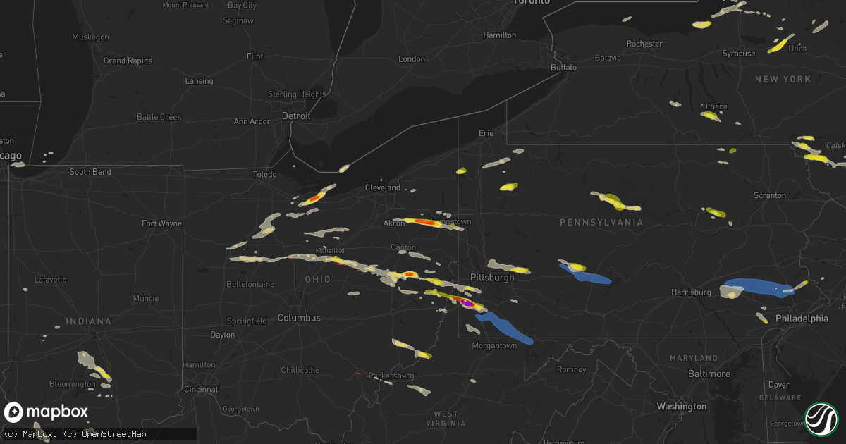
Hail Map on August 12, 2023
Get this storm
August 12 map
$229
one time, instant access
Download today. No call, no setup
Keep the $229
Bought the map and want the full workflow? Apply the entire $229 to a subscription within 7 days. None of it is wasted.
Every map, not just this one
This buys you this map. Subscription and you get every map we run, in the markets you choose from a few cities to whole states to nationwide. Plus real-time alerts the moment a storm fires.
Contact data
Name, contact info, occupancy, even credit band for addresses in the footprint. You go from where it hit to who to call.
Become the source they trust
Unlimited branding weather history reports on demand. You already have the documented answer ready for the property owner, and you are the one who showed up with it.
Property data and RoofTrace estimates
Pull up any address you have got, its value and the exact code rules for that jurisdiction, straight from One Click Code. Then RoofTrace estimates the squares, pitch, and roof value, priced the way you price.
States Impacted by Hail Map on August 12, 2023
Storm reports
Pennsylvania
| Date | Description |
|---|---|
| 08/12/20236:58 PM CDT | Trees down on brush run road and green cove road. |
| 08/12/20236:46 PM CDT | Tree down on sr-403 |
| 08/12/20236:23 PM CDT | Multiple trees down. Strickland hill rd... Springville... Pa. Time estimated by radar. |
| 08/12/20236:23 PM CDT | Wires down near button rd and strickland hill rd. |
| 08/12/20236:10 PM CDT | Numerous trees down. |
| 08/12/20236:01 PM CDT | Report of multiple down trees in the area. Time estimated based on radar. |
| 08/12/20236:00 PM CDT | Several large trees down in the north washington area |
| 08/12/20235:59 PM CDT | Report of tree down on house. Time estimated based on radar. |
| 08/12/20235:56 PM CDT | Report of many large trees down along beaver run road. Time estimated based on radar. |
| 08/12/20235:56 PM CDT | A local report indicates 1.00 inch wind near 1 ESE North Washington |
| 08/12/20235:55 PM CDT | A local report indicates 1.00 inch wind near 1 E North Washington |
| 08/12/20235:55 PM CDT | A local report indicates 1.00 inch wind near 1 NW North Washington |
| 08/12/20235:52 PM CDT | Tree limbs down. Mping report |
| 08/12/20235:48 PM CDT | Mping report |
| 08/12/20235:48 PM CDT | Photo provided |
| 08/12/20235:45 PM CDT | A local report indicates 1.25 inch wind near 1 NW Alcoa Center |
| 08/12/20235:42 PM CDT | Report and photo of large uprooted tree in west deer township. Time estimated based on radar. |
| 08/12/20235:33 PM CDT | Hail near springdale with photograph provided |
| 08/12/20235:16 PM CDT | Report of multiple trees down along bakerstown road. Time estimated based on radar. |
| 08/12/20235:15 PM CDT | Trees down from downburst wind |
| 08/12/20235:11 PM CDT | Quarter size hail reported in plumsteadville. Picture provided via social media. Time estimated via radar. |
| 08/12/20235:03 PM CDT | Numerous trees down. Roof partially blown off of a home. |
| 08/12/20235:00 PM CDT | Multiple trees down. Time estimated from radar. |
| 08/12/20235:00 PM CDT | Numerous trees down. |
| 08/12/20235:00 PM CDT | Pictures sent in of quarter-sized hail near plumstead township. Time estimated from radar. |
| 08/12/20234:44 PM CDT | Trees and wires down. Time estimated. |
| 08/12/20234:40 PM CDT | Trees and wires down. Time estimated. |
| 08/12/20234:40 PM CDT | Trees and wires down. Time estimated. |
| 08/12/20234:33 PM CDT | Ppl reports tree limbs on wires near harleysville and franconia. Time estimated from radar. |
| 08/12/20234:32 PM CDT | Trees down on wires resulting in power outages. Time estimated via radar. |
| 08/12/20234:30 PM CDT | Trees and wires down |
| 08/12/20234:15 PM CDT | Corrected location from the previous summit hill report. Numerous trees and power lines down near the intersection of pa-93 and wetzel run drive in weatherly. Pictures |
| 08/12/20234:15 PM CDT | Numerous trees and power lines down near intersection of pa-93 and wetzel run drive in weatherly. Pictures provided via social media. Time estimated via radar. |
| 08/12/20234:08 PM CDT | Public sends in picture of downed tree on hickory mill road. Time estimated from radar. |
| 08/12/20234:00 PM CDT | Report of tree down into house on marlborough springs road. Time estimated from radar. |
| 08/12/20233:51 PM CDT | Report from mping: trees uprooted or snapped; roof blown off. Update: similar reports received in nescopeck township from emergency managers. |
| 08/12/20233:46 PM CDT | Tree down on unionville wawaset road. Time estimated from radar. |
| 08/12/20233:43 PM CDT | Trees and wires down on unionville wawaset road. Time estimated from radar. |
| 08/12/20233:39 PM CDT | Trees and wires down on route 842 and cannery road in newlin. Time estimated from radar. |
| 08/12/20233:30 PM CDT | Numerous trees down. |
| 08/12/20233:29 PM CDT | Multiple trees down in and around cameron. Time estimated by radar. |
| 08/12/20233:23 PM CDT | Report of multiple trees down in southeast jefferson county. Time estimated based on radar. |
| 08/12/20233:01 PM CDT | Report from mping: quarter |
| 08/12/20232:59 PM CDT | Multiple reports from mping highlight tree limbs reported down throughout millville. |
| 08/12/20232:58 PM CDT | Two trees down on the road. Time estimated. |
| 08/12/20232:50 PM CDT | Report from mping: quarter |
| 08/12/20232:48 PM CDT | Time estimated. |
| 08/12/20232:48 PM CDT | Multiple trees along with limbs down. Report from mping. |
| 08/12/20232:46 PM CDT | Report from mping: quarter |
| 08/12/20232:40 PM CDT | Tree down in wires. Time estimated. |
| 08/12/20232:20 PM CDT | Tree and wires down. Time estimated by radar. |
| 08/12/20232:04 PM CDT | A few calls for trees and wires down in crawford co including near spartansburg. Nickel sized hail also reported in spartansburg. |
| 08/12/20231:02 PM CDT | Reports of multiple trees down near and on route 62. Time estimated by radar. |
| 08/12/202312:33 PM CDT | A few large limbs and trees downed... Some across a road. It is unknown if this tree damage was directly associated with a funnel cloud that was observed in the area or |
| 08/12/202312:00 AM CDT | Multiple trees reported down in bedminster township. Time estimated from radar. |
| 08/11/202311:50 PM CDT | A 70 foot white pine tree was uprooted near the corner of pecan drive and lansdale ave in lansdale. Photos received via social media. Time estimated from radar. |
| 08/11/202311:50 PM CDT | A 70 foot white pine tree was uprooted near the corner of pecan drive and lansdale ave in lansdale. Photos received via social media. Time estimated from radar. |
| 08/11/202311:47 PM CDT | Report from mping: 1-inch tree limbs broken; shingles blown off. Time estimated from radar. |
| 08/11/202311:46 PM CDT | Multiple trees down in west rockhill township. Time estimated from radar. |
| 08/11/202311:37 PM CDT | Tree down at hoppenville road and lumber street. Time estimated from radar. |
| 08/11/202311:37 PM CDT | Down tree in wires on gravel pike. Time estimated from radar. |
| 08/11/202311:37 PM CDT | Several trees down across geryville pike near hoppenville road. Picture sent in via facebook. Time estimated from radar. |
| 08/11/202311:35 PM CDT | Down tree in wires on west ridge pike at swamp pike. Time estimated from radar. |
| 08/11/202311:34 PM CDT | Multiple trees down across new hanover township. Time estimated from radar. |
| 08/11/202311:31 PM CDT | Trees down. Time estimated from radar. |
| 08/11/202311:30 PM CDT | Trees down in barto. Time estimated from radar. |
| 08/11/202311:29 PM CDT | Multiple trees down across douglass township. Time estimated from radar. |
| 08/11/202311:29 PM CDT | Multiple trees reported down in pottstown. Time estimated from radar. |
| 08/11/202311:28 PM CDT | Multiple trees reported down in upper pottsgrove township. Time estimated from radar. |
| 08/11/202311:28 PM CDT | Large tree down which also brought down wires on groff road at merkle road in district township. Photo received on social media. Time estimated from radar. |
| 08/11/202311:28 PM CDT | Report from mping: 3-inch tree limbs broken; power poles broken. Time estimated from radar. |
| 08/11/202311:27 PM CDT | Multiple trees reported down in stowe. Time estimated from radar. |
| 08/11/202311:20 PM CDT | Report of trees down around cumru township... Pa. |
| 08/11/202311:20 PM CDT | Report of trees down around south heidelberg township. |
| 08/11/202311:16 PM CDT | Trees and power lines down resulting in several road closures. Time estimated from radar. |
| 08/11/202311:15 PM CDT | Numerous trees and wires down in exeter township. Time estimated from radar. |
| 08/11/202311:10 PM CDT | Report from mping: trees uprooted or snapped. Time estimated from radar. |
| 08/11/202311:06 PM CDT | Trees down on holtzman road. |
| 08/11/202311:04 PM CDT | Tree down across creek road... And the tree was struck by a car. No injuries reported. |
| 08/11/202311:00 PM CDT | Report from mping: 1-inch tree limbs broken; shingles blown off. Time estimated from radar. |
| 08/11/20238:32 PM CDT | Trees down in dilliner |
| 08/11/20238:30 PM CDT | Tree down on road. |
| 08/11/20238:30 PM CDT | Multiple trees down along jeffrey lane. |
| 08/11/20238:28 PM CDT | Trailer collapse with occupants trapped |
| 08/11/20238:28 PM CDT | Report and photos of damage to tents set up in festival area along main street. Time estimated based on radar. |
| 08/11/20238:28 PM CDT | Trees and wires down along walnut hill road. |
| 08/11/20238:26 PM CDT | Mping report of trees uprooted. Time based on radar. |
| 08/11/20238:26 PM CDT | Trees down in the city of greensboro. |
| 08/11/20238:24 PM CDT | Large limbs down |
| 08/11/20238:21 PM CDT | Corrects previous tstm wnd dmg report from 2 ese ashville. Large tree down along route 36. Time estimated by radar. |
| 08/11/20238:21 PM CDT | Power lines down along mcclellandtown road and spring road. |
| 08/11/20238:18 PM CDT | Power lines down along and over route 53. Time estimated by radar. |
| 08/11/20238:16 PM CDT | Multiple trees down in the city of carmichaels |
| 08/11/20238:15 PM CDT | Multiple trees down along gallitzin rd. Time estimated by radar. |
| 08/11/20238:10 PM CDT | Trees down in rices landing. |
| 08/11/20238:01 PM CDT | Large tree down along route 36. Time estimated by radar. |
| 08/11/20238:00 PM CDT | Report of several trees dow near bethlehem-center elementary school. Time estimated based on radar. |
| 08/11/20237:54 PM CDT | Multiple trees down reported in cambria twp. Time estimated by radar. |
| 08/11/20237:52 PM CDT | Trees down in the city of wind ridge. |
| 08/11/20237:40 PM CDT | Tree limbs down. Mping report |
| 08/11/20237:40 PM CDT | Barn destroyed along brush run rd and trees down along lone pine rd |
| 08/11/20237:35 PM CDT | Trees down at 27 mile marker on i-79. Time estimated. |
| 08/11/20237:34 PM CDT | Trees down on laurel run road. |
| 08/11/20237:32 PM CDT | Large branches down. Time estimated. |
| 08/11/20237:24 PM CDT | A township shed and outbuilding were destroyed along prosperity pike. Damage was coincident with a continuing tornado debris signature. |
| 08/11/20237:22 PM CDT | Barn levelled and trees down. Damage coincident with tornado couplet with debris signature. |
| 08/11/20237:18 PM CDT | A local report indicates 1.75 inch wind near 1 NNE Lagonda |
| 08/11/20237:15 PM CDT | Mping report |
| 08/11/20237:14 PM CDT | Hailstone fell on hawthorn road. |
| 08/11/20237:13 PM CDT | Roof ripped off home on cracraft road. |
| 08/11/20237:12 PM CDT | Multiple photos of measured 2 inch hail in the claysville area |
| 08/11/20237:11 PM CDT | Multiple trees and wires down in a concentrated swath along valley view rd. Likely start of tornado just preceding the development of a prolonged tornado debris signatu |
| 08/11/20237:08 PM CDT | Photo provided |
| 08/11/20237:08 PM CDT | A local report indicates 2.00 inch wind near 1 SSE Taylorstown |
| 08/11/20237:00 PM CDT | A local report indicates 1.25 inch wind near 3 NW Claysville |
New Mexico
| Date | Description |
|---|---|
| 08/12/20233:36 PM CDT | Report of thunderstorm wind damage causing power poles to be knocked down along hwy 56 west of clayton b/w mms 73-74. Power was lost for a few hours. |
| 08/12/20233:15 PM CDT | Destroyed a wall and blew part of the roof off of a horse barn. Also... Blew two fiberglass windows out of a metal barn. |
Maryland
| Date | Description |
|---|---|
| 08/11/20239:39 PM CDT | Tree down on the 1100 block of north hill road |
West Virginia
| Date | Description |
|---|---|
| 08/12/20236:41 PM CDT | Report of tree down in area. |
| 08/11/20239:23 PM CDT | Report of tree down. Time estimated based on radar. |
| 08/11/20239:20 PM CDT | County 911 reports tree down on berry run rd north of flemington. |
| 08/11/20239:20 PM CDT | County 911 reports trees down on brushy fork road southeast of anmoore. |
| 08/11/20239:14 PM CDT | Report of tree down. Time estimated based on radar. |
| 08/11/20239:10 PM CDT | Report of tree down. Time estimated based on radar. |
| 08/11/20238:50 PM CDT | County 911 has multiple reports of trees down in and northwest of lumberport. |
| 08/11/20238:47 PM CDT | County 911 reports trees down along state route 23 near shirley. |
| 08/11/20238:44 PM CDT | Report of trees down in area. Time estimated based on radar. |
| 08/11/20238:41 PM CDT | Report of tree down on norway road. Time estimated based on radar. |
| 08/11/20238:40 PM CDT | Report of tree down on manley chapel road. Time estimated based on radar. |
| 08/11/20238:37 PM CDT | Report of downed trees in the city area. Time estimated based on radar. |
| 08/11/20238:37 PM CDT | Report of tree down near intersection of 4 state road and aberdean road. Time estimated based on radar. |
| 08/11/20238:32 PM CDT | Trees down on big battle run. Time estimated by radar. |
| 08/11/20238:30 PM CDT | Tree on road on us-19 at mile marker 17.6. |
| 08/11/20238:28 PM CDT | Report of trees down in the area. Time estimated based on radar. |
| 08/11/20238:20 PM CDT | Corrects time of previous tstm wnd dmg report from 7 n west union. County 911 reports trees down along state route 23 near shirley. |
| 08/11/20238:15 PM CDT | County 911 reports trees down near alma along route 18. |
| 08/11/20238:14 PM CDT | Report of down trees in the area. Time estimated based on radar. |
| 08/11/20237:59 PM CDT | Report of trees down in the area. Time estimated based on radar. |
| 08/11/20237:57 PM CDT | Report of trees down in the area. Time estimated based on radar. |
| 08/11/20237:28 PM CDT | Weather spotter called in that they can see rotation from their house in belleville... But are unsure whether anything is on the ground currently due to the trees nearb |
Wyoming
| Date | Description |
|---|---|
| 08/12/20236:35 PM CDT | A local report indicates 1.75 inch wind near 5 ESE Sundance |
| 08/12/20236:28 PM CDT | Mping report |
| 08/12/20236:25 PM CDT | A local report indicates 1.50 inch wind near Sundance |
New Jersey
| Date | Description |
|---|---|
| 08/12/202312:47 PM CDT | Three trees down in lindenwold. Time estimated via radar. |
| 08/12/20231:09 AM CDT | Several large tree limbs down around town. |
| 08/12/20231:07 AM CDT | Tree down near sky top picnic area. |
| 08/12/20231:06 AM CDT | Numerous tree limbs and power lines down. Portions of berkley heights is without power. |
| 08/12/202312:58 AM CDT | Two trees on a house and also some snapped tree tops on haas road between keats road and pond hill road.time estimated from radar. |
| 08/12/202312:58 AM CDT | Several large tree limbs down. Photos received via social media. Time estimated from radar. |
| 08/12/202312:54 AM CDT | Large tree limbs down which damaged a car. Time estimated from radar. |
| 08/12/202312:54 AM CDT | Large tree limbs down which damaged a car. Time estimated from radar. |
| 08/12/202312:53 AM CDT | Trees down on keats road. Time estimated from radar. |
| 08/12/202312:48 AM CDT | Tree on house in bernardsville. Time estimated from radar. |
| 08/12/202312:45 AM CDT | Trees down. Photos received via social media. Time estimated from radar. |
| 08/12/202312:41 AM CDT | Trees down on roycefield road in hillsborough township. Time estimated from radar. |
| 08/12/202312:20 AM CDT | Trees down on route 12 at whiskey lane in franklin township. Time estimated from radar. |
| 08/12/202312:16 AM CDT | Multiple trees down in milford. Time estimated from radar. |
South Carolina
| Date | Description |
|---|---|
| 08/12/20236:15 PM CDT | Several trees blown down near the intersection of dagnal rd and hopewell rd. |
| 08/12/20236:00 PM CDT | Tree down on 10th street in gaffney. |
| 08/12/20235:48 PM CDT | Multiple trees down in goucher white plains area. |
| 08/12/20235:27 PM CDT | Trees and power lines down at many locations across spartanburg county. |
| 08/12/20235:21 PM CDT | Tree down on road at intersection of hayes dr and cooley rd... Later removed by county road department. Time estimated. |
| 08/12/20235:20 PM CDT | Scdot responded to a tree blocking part of the road near intersection of durbin rd and sullivan rd. |
| 08/12/20235:17 PM CDT | Pine tree on railroad track near old laurens rd and owings park dr. Time estimated. |
| 08/12/20235:11 PM CDT | Trees down blocking roads at 7 locations around anderson. |
| 08/12/20235:02 PM CDT | Social media picture of a tree down across a driveway off fork shoals rd. |
| 08/12/20235:00 PM CDT | Tree down blocking road on hampton road. |
| 08/12/20234:55 PM CDT | Multiple trees down in the north side of greenville. |
| 08/12/20234:55 PM CDT | Multiple trees down on the east side of greenville. |
Arkansas
| Date | Description |
|---|---|
| 08/12/20235:09 AM CDT | Road blocked by downed tree in lowell. Time estimated from radar. |
| 08/12/20235:09 AM CDT | Road blocked by downed tree in lowell. Time estimated from radar. (t |
| 08/12/20235:05 AM CDT | Several large tree limbs snapped... Pics from social media. Time estimated from radar. |
Kentucky
| Date | Description |
|---|---|
| 08/12/20231:03 PM CDT | Tree down on bar creek road. Time estimated from radar. |
| 08/12/20239:50 AM CDT | Dispatch reported power lines down on hepburn avenue. Time estimated from radar. |
| 08/12/20239:46 AM CDT | Tree and power line damage resulted in damage to the siding of a home on breckinridge street. Time estimated from radar. |
| 08/12/20239:21 AM CDT | Trees down on highway 45. |
| 08/12/20239:20 AM CDT | Several trees down on county line road just northwest of water valley. |
| 08/12/20239:20 AM CDT | Tree fell on a house along hwy 1529. |
| 08/12/20239:20 AM CDT | Kentucky transportation cabinet is reporting numerous trees down along the purchase parkway and areas along the graves-hickman county line. |
| 08/12/20239:15 AM CDT | Kentucky transportation cabinet reports numerous trees down across hickman county. Trees are down along ky 307... Ky 58... Ky 239... Ky 1529... And ky 1708. |
| 08/12/20239:13 AM CDT | Storm damage survey results confirm an ef-1 tornado began with a cluster of damage along ky-307 just south of johnson rd... Including on bizzle rd and laine rd. Around |
| 08/12/20239:13 AM CDT | Widespread tree and power line damage countywide. Trees on houses and roofs off outbuildings. Cities of fulton and hickman both with significant damage. |
| 08/12/20239:06 AM CDT | Quite a few trees down on highway 239 near the fulton county line. |
| 08/12/20239:05 AM CDT | Trees down in hickman via ham radio operator. Another ham indicated 60 mph winds or more. |
| 08/12/20239:05 AM CDT | Widespread trees and utility lines down in hickman and throughout fulton county. Trees were blocking sections of hwy 125 and ky highway 166. |
| 08/12/20239:04 AM CDT | Several trees down. |
| 08/12/20238:56 AM CDT | Storm damage survey results confirm an ef-1 tornado began in the terrace drive and sunset street area of hickman with damage to trees and power lines. This tornado trac |
Missouri
| Date | Description |
|---|---|
| 08/12/20238:50 AM CDT | Several trees down. |
| 08/12/20235:17 AM CDT | Numerous reports of trees and limbs down in cassville and just north. |
Alabama
| Date | Description |
|---|---|
| 08/12/20236:50 PM CDT | A few trees were blown down on cr 2 near lake martin. |
| 08/12/20236:34 PM CDT | A few trees were blown down near cr 8. |
| 08/12/20235:58 PM CDT | Trees down in the area of county roads 48 and 54. |
| 08/12/20235:55 PM CDT | Tree down along the tallapoosa/chambers county line on dudleyville rd. |
| 08/12/20235:50 PM CDT | Tree down near the intersection of county roads 158 and 160. |
| 08/12/20235:36 PM CDT | Several trees down by downburst near shorter. Time estimated via radar. |
| 08/12/20235:34 PM CDT | Tree down with vehicle accident on old u.s. 431 and home damaged by lightning on highland ave. |
| 08/12/20235:21 PM CDT | Tree down near lee road 236 and lee road 5 in phenix city. |
| 08/12/20235:10 PM CDT | Several trees down on county roads 15... 26... And 49. |
| 08/12/20235:01 PM CDT | Tree down on lee road 146 near highway 51. |
| 08/12/20235:00 PM CDT | A fallen tree resulted in a power outage along s park ave. |
| 08/12/20234:57 PM CDT | There were at least 25 areas with trees down within the city of dothan. |
| 08/12/20234:57 PM CDT | Trees were blown down onto power lines on forrester road and a tree was snapped on beverlye road. |
| 08/12/20234:52 PM CDT | Public reported 2 trees down on hwy-52. |
| 08/12/20234:51 PM CDT | Geneva county dispatch reported a tree down on e cr-70. |
| 08/12/20234:49 PM CDT | A privacy fence was blown down in the headland area. |
| 08/12/20234:48 PM CDT | Henry county dispatch reported a tree and powerlines down on cr-5... 1900 block. |
| 08/12/20234:42 PM CDT | Three trees down on powerlines on state lake rd at highway 49. Road is blocked. |
| 08/12/20234:22 PM CDT | Social media report of several large trees down at st. Michael church. |
| 08/12/20234:21 PM CDT | Trees were blown down. |
| 08/12/20234:21 PM CDT | A least a half dozen reports of trees blown down in the city of gadsden. |
| 08/12/20234:15 PM CDT | Trees down near highway 278 along the cherokee/cleburne county line. |
| 08/12/20234:04 PM CDT | A tree was blown down and blocking the roadway on us highway 278. |
| 08/12/20234:00 PM CDT | Henry county emergency management reported trees down on residences on cr-107 east near abbeville. |
| 08/12/20233:36 PM CDT | Trees were blown down. |
| 08/12/20233:25 PM CDT | Coffee county dispatch reported 3 downed trees on cr-412. |
| 08/12/20233:21 PM CDT | Corrects previous tstm wnd dmg report from 1 nne gadsden. A least a half dozen reports of trees blown down in the city of gadsden. |
| 08/12/20233:21 PM CDT | Corrects previous tstm wnd dmg report from springville. Trees were blown down. |
| 08/12/20232:45 PM CDT | Multiple trees were blown down on al highway 75 north of oneonta. |
| 08/12/20232:45 PM CDT | Multiple trees and power lines were blown down on al highway 75 north of oneonta. The highway was impassable near souls chapel road. |
| 08/12/20232:38 PM CDT | Multiple trees were blown down on highway 79 near blountsville. The highway is impassable in spots. |
| 08/12/20232:38 PM CDT | Multiple trees were blown down on highway 79 north of cleveland. |
| 08/12/20232:13 PM CDT | Report of a tree down near the 700 block of county road 783 west of holly pond. Time estimated by radar. |
| 08/12/20232:13 PM CDT | Report of a tree down near the 100 block of county road 798 west of holly pond. Time estimated by radar. |
Indiana
| Date | Description |
|---|---|
| 08/12/20238:14 AM CDT | Trained weather spotter measured a hail stone of 1 inch. |
| 08/12/20237:40 AM CDT | Large portion of a tree mostly snapped off. Small to medium size branches of two other trees partially and completely snapped off. A portion of a soy bean crop was part |
Georgia
| Date | Description |
|---|---|
| 08/12/20236:10 PM CDT | Tree down at lower glass bridge rd and kimbrough rd. |
| 08/12/20236:05 PM CDT | Numerous |
| 08/12/20236:05 PM CDT | Tree down at ws willowcrest way and s willowcrest dr. |
| 08/12/20236:00 PM CDT | Tree and lines down associated with outflow ahead of 2nd wave of storms on the day at shields road and north henry blvd. |
| 08/12/20235:55 PM CDT | Tree down at hogansville rd near hogansville pump station rd. |
| 08/12/20235:55 PM CDT | Tree down at greeville rd and lone oak rd. |
| 08/12/20235:50 PM CDT | Tree down at williams rd between leisure cove dr and running creek dr. |
| 08/12/20235:15 PM CDT | Tree downed along southland rd and sr 90. |
| 08/12/20235:00 PM CDT | Tree fell and snapped power pole near shoal creek and perry smith rd. |
| 08/12/20235:00 PM CDT | Tree down on bowman highway. |
| 08/12/20234:55 PM CDT | Tree down near bowman. |
| 08/12/20234:55 PM CDT | Tree down on royston highway. |
| 08/12/20234:50 PM CDT | Tree fell on a home along rome street in bowdon. |
| 08/12/20234:50 PM CDT | Tree on home along grammar school dr in bowdon. |
| 08/12/20234:48 PM CDT | Tree down on road in bobby brown state park. |
| 08/12/20234:46 PM CDT | Tree down in road along 700 block of brookshire ct. |
| 08/12/20234:41 PM CDT | Tree down across roadway near intersection of h d atha rd and jersey social circle. |
| 08/12/20234:41 PM CDT | Tree fell on power pole... Snapping it and bringing lines down onto front porch of home along the 5000 block of center hill church rd. |
| 08/12/20234:41 PM CDT | Large oak down across road at 900 block of park st. |
| 08/12/20234:35 PM CDT | 2 reports of trees down near butts and newton county border per ema. |
| 08/12/20234:35 PM CDT | Per ema... Multiple trees downed along everett mountain road at several locations. |
| 08/12/20234:33 PM CDT | Multiple trees down in canon. |
| 08/12/20234:30 PM CDT | A tree was downed in the 400 block of wisso rd. |
| 08/12/20234:25 PM CDT | A tree was reported down in the 1500 block of rehobeth rd. |
| 08/12/20234:25 PM CDT | Tree fell on powerlines along 200 block of douglas st. |
| 08/12/20234:17 PM CDT | Multiple trees down in carnesville area. |
| 08/12/20234:16 PM CDT | Powerlines down south of lee rd sw on lake dr sw at amy rd and mink livesy rd near bryant dr. |
| 08/12/20234:15 PM CDT | Power lines were downed in the 100 block of dobbins circle. |
| 08/12/20234:05 PM CDT | Numerous trees down along tiffany dr and carlow ct. One tree on a home. Another fell and crushed a parked vehicle. |
| 08/12/20234:00 PM CDT | Numerous reports of trees and powerlines down in northern henry county per ema. |
| 08/12/20233:55 PM CDT | Awning at exxon station along virginia ave damakers creek rd. |
| 08/12/20233:55 PM CDT | Numerous trees down in south atlanta... East point... Hapeville... And surrounding communities. Locations include grant st and nolan st... 7th st and 3rd ave... Memoria |
| 08/12/20233:55 PM CDT | Awning at exxon station along virginia ave damaged and hanging down over gas pumps. |
| 08/12/20233:52 PM CDT | Tree down near intersection of flat shoals ave se and ormewood ave se. |
| 08/12/20233:50 PM CDT | Tree blocking i-85 sb just before riverdale rd. |
| 08/12/20233:50 PM CDT | Social media report of tree down near judson bulloch rd between whitehouse pkwy and and river rd. |
| 08/12/20233:50 PM CDT | Tree down along connell ave sw. |
| 08/12/20233:38 PM CDT | Tree down at butner rd and camp creek pkwy sw. |
| 08/12/20233:28 PM CDT | Tree down near intersection of tell rd and rivertown rd. |
| 08/12/20233:28 PM CDT | Tree down near intersection of tell rd and rivertown rd. Aged and hanging down over gas pumps. |
| 08/12/20233:05 PM CDT | Tree down along vernon grove rd and rico rd in chattahoochee hills. |
| 08/12/20233:05 PM CDT | Tree down along campbellton redwine rd and s fulton pkwy. |
| 08/12/20232:33 PM CDT | Gdot reporting a tree downed along hwy 411 near liberty church rd. |
Connecticut
| Date | Description |
|---|---|
| 08/11/20238:35 PM CDT | Tree down on saw mill city road. |
| 08/11/20238:15 PM CDT | Powerline down and sparking. |
| 08/11/20238:10 PM CDT | Several trees down blocking roads across town including pocono lane... Lindencrest drive... And flintlock drive. |
| 08/11/20238:10 PM CDT | Tree down on vehicle on west purchase road. |
| 08/11/20238:05 PM CDT | Tree down on wires on route 37 south of durgy lane. |
| 08/11/20238:02 PM CDT | Multiple reports of damaged trees in the vicinity of town line rd and keeler rd near bridgewater/roxbury town line. |
| 08/11/20237:55 PM CDT | Tree and wires down on candlelight drive. |
| 08/11/20237:51 PM CDT | 3 power poles down due to trees down on the border of sherman and new fairfield. |
| 08/11/20237:45 PM CDT | Two poles down. Time estimated from radar. |
South Dakota
| Date | Description |
|---|---|
| 08/12/20236:56 PM CDT | Mping report |
| 08/12/20236:55 PM CDT | Mping report |
| 08/12/20236:51 PM CDT | Mping report |
| 08/12/20236:46 PM CDT | Mping report |
| 08/12/20236:45 PM CDT | A local report indicates 1.50 inch wind near 2 NE Custer |
| 08/12/20235:52 PM CDT | A local report indicates 61 MPH wind near 8 SSW Folsom |
| 08/12/20235:50 PM CDT | A local report indicates 1.50 inch wind near 8 SSW Folsom |
| 08/12/20235:15 PM CDT | Mobile home tipped over |
| 08/12/20235:05 PM CDT | A local report indicates 2.00 inch wind near Hermosa |
| 08/12/20235:05 PM CDT | A local report indicates 1.75 inch wind near 1 W Hermosa |
| 08/12/20234:45 PM CDT | Fire dispatch reports power line down from wind dmg |
| 08/12/20234:17 PM CDT | Mping report |
| 08/12/20234:10 PM CDT | A local report indicates 1.75 inch wind near N Rockerville |
| 08/12/20234:00 PM CDT | A local report indicates 2.00 inch wind near Sheridan Lake |
| 08/12/20233:20 PM CDT | A local report indicates 1.50 inch wind near 2 NNE Silver City |
| 08/12/20233:20 PM CDT | Mostly pea size hail with a few quarters. |
| 08/12/20232:55 PM CDT | A local report indicates 1.25 inch wind near 6 SSE Brownsville |
| 08/12/20232:42 AM CDT | A local report indicates 1.00 inch wind near 6 SE Oglala |
| 08/12/20231:18 AM CDT | A local report indicates 1.00 inch wind near 6 SSW Hot Springs |
| 08/12/202312:42 AM CDT | A local report indicates 1.00 inch wind near 2 WSW Argyle |
| 08/11/202311:30 PM CDT | A local report indicates 1.75 inch wind near Sharps Corner |
| 08/11/20239:32 PM CDT | Mping report |
| 08/11/20238:18 PM CDT | A local report indicates 2.00 inch wind near 4 WNW Rockyford |
| 08/11/20238:10 PM CDT | A local report indicates 2.00 inch wind near 8 WNW Rockyford |
| 08/11/20237:10 PM CDT | A local report indicates 1.00 inch wind near 7 E Custer |
Florida
| Date | Description |
|---|---|
| 08/12/20236:00 PM CDT | Jackson county dispatch reported downed trees on chester rd. |
| 08/12/20235:15 PM CDT | Corrects time of previous tstm wnd dmg report from 1 n star. Jackson county dispatch reported downed trees on chester rd. |
Colorado
| Date | Description |
|---|---|
| 08/12/20235:20 PM CDT | A local report indicates 70 MPH wind near 8 S Springfield |
Ohio
| Date | Description |
|---|---|
| 08/12/20236:35 PM CDT | Storm spotter called saying a tornado is on the ground heading east on highway 33. Says he has video confirmation. |
| 08/12/20236:33 PM CDT | Corrects previous tornado report from 1 ssw athens. An ef1 tornado with maximum winds up to 100 mph tracked 2.3 miles across athens county touching down near angel ridg |
| 08/12/20236:10 PM CDT | Trees down along river rd and river hill rd sw |
| 08/12/20236:09 PM CDT | Report of broken tree branches 5 inches thick. Time estimated based on radar. |
| 08/12/20236:05 PM CDT | Trees down along i-77 |
| 08/12/20236:05 PM CDT | Trees down on millers ridge rd sw |
| 08/12/20236:04 PM CDT | Trees down on stone creek rd... Including on a vehicle with two trapped occupants |
| 08/12/20236:03 PM CDT | Trees down along i-77 |
| 08/12/20235:57 PM CDT | Trees down along crooked run rd and funk rd |
| 08/12/20235:50 PM CDT | Trees down along dover rd |
| 08/12/20235:40 PM CDT | Tree downed across road near state route 515 and county road 168. Time estimated via radar. |
| 08/12/20235:18 PM CDT | Tree downed across ohio route 39. Time estimated via radar. |
| 08/12/20234:52 PM CDT | A few roads closed between perrysville and loudonville due to downed trees and wires. Time estimated via radar. |
| 08/12/20234:50 PM CDT | Report from mping: quarter |
| 08/12/20234:24 PM CDT | Tree down on trappan-scio road and hanover ridge road. |
| 08/12/20234:12 PM CDT | Trees down along bramble rd and dyewood rd |
| 08/12/20234:07 PM CDT | Trees and power lines down across highway 212 |
| 08/12/20234:05 PM CDT | Several trees were blown down blocking roads in poland. Video from yng tv media. Time was estimated by radar. |
| 08/12/20234:04 PM CDT | Trees down in vicinity of leesville to sherrodsville |
| 08/12/20233:58 PM CDT | A local report indicates 1.75 inch wind near Sherrodsville |
| 08/12/20233:52 PM CDT | Tree reported on house in austintown. No cross street given. Time estimated by radar. |
| 08/12/20233:45 PM CDT | Wires down at the intersection of baltzey road southeast and ridge road. Time estimated. |
| 08/12/20233:42 PM CDT | Wires down on state route 800. Time estimated. |
| 08/12/20233:30 PM CDT | Trees and wires down on delaware drive se. Time estimated. |
| 08/12/20233:30 PM CDT | Reported via social media. |
| 08/12/20233:30 PM CDT | Picture from social media of half dollar size hail. |
| 08/12/20233:28 PM CDT | A local report indicates 1.00 inch wind near 1 W Dover |
| 08/12/20233:25 PM CDT | Video on social media of ping pong to golf ball size hail near lake milton. |
| 08/12/20233:24 PM CDT | County ema reported roof damage to a historical building and down powerlines in the palmyra township area. Storm damage was possibly caused by brief tornado. |
| 08/12/20233:21 PM CDT | A few trees and power lines downed in russel township... Munson... And burton. |
| 08/12/20233:19 PM CDT | Tree on wires on township road 401. Time estimated via radar. |
| 08/12/20232:20 PM CDT | An nws storm survey confirmed a weak... Intermittent ef-0 tornado with a maximum estimated wind speed of 70 mph occurred in holmes county on august 12... 2023. The torn |
| 08/12/20231:53 PM CDT | A tree limb poked through the roof and ceiling of a home and extended into a bedroom. The photo was shared on social media by a broadcast meteorologist. |
| 08/12/20231:44 PM CDT | Spotter reported a brief touchdown near the intersection of i-71 and highway 13. Tornado touchdown just northeast of walmart away from structures and in the wood. No da |
| 08/12/20231:27 PM CDT | A couple of trees reported downed near mansfield-washington rd. Time estimated via radar. |
| 08/12/20231:25 PM CDT | Large tree downed across kings corners road e. Time estimated via radar. |
| 08/12/20231:25 PM CDT | Large tree downed across kings corners road e. Time estimated via radar. |
| 08/12/20231:23 PM CDT | Report from mping: quarter |
| 08/12/202312:59 PM CDT | Two trees reported downed on roads near polk twp. One fell across ohio 19 and one fell along shearer road. |
| 08/12/202312:45 PM CDT | Power lines and trees down on bogart road. Storm damage picture from social media. |
| 08/12/202312:35 PM CDT | Trees and power lines down countywide. Time estimated from radar. |
| 08/12/202312:35 PM CDT | Spotter reported golf ball sized hail and 80 mph winds near the intersection of route 2 and route 4. He also reported windows blown out and tv antenna blown down at his |
| 08/12/202312:35 PM CDT | Golf ball size hail reported by trained weather spotter. |
| 08/12/202312:35 PM CDT | Ema reporting several power lines and power poles blown down. A couple poles were reported on cars off highway 4. |
| 08/12/202312:12 PM CDT | Storm spotter reported damage to a barn... Tree down... And debris scattered in field. Possible tornado may have caused the damage. |
| 08/12/202312:08 PM CDT | A brief tornado touched down just south of the intersection of state route 309 and dry lane road n. Part of the roof was torn off of an outbuilding with some debris thr |
| 08/12/202312:00 PM CDT | Several trees down in bascom and hopewell township. Time estimated from radar. |
| 08/12/202311:50 AM CDT | Numerous trees down in and around cleveland heights. Time estimated from radar. |
| 08/12/202311:46 AM CDT | Tornado reported on the ground in the city of kenton. |
| 08/12/202311:46 AM CDT | Ef1 tornado confirmed in hardin county... Ohio. Damage to trees and structures on the south side of the city of kenton. Estimated winds of 90 mph. |
| 08/12/202311:32 AM CDT | Large tree fell into the back of a house in findlay and took down power lines. Time estimated from radar. |
| 08/11/20237:11 PM CDT | A couple of trees down along state route 564 and low gap road. |
| 08/11/20237:10 PM CDT | Report of trees and power lines down. Time estimated based on radar. |
| 08/11/20237:06 PM CDT | Report of numerous trees and power lines down. Time estimated based on radar. |
| 08/11/20237:06 PM CDT | A number of trees and power lines down near kagg hill road and maynard road. |
| 08/11/20237:03 PM CDT | Report of numerous trees snapped or uprooted in the hidden springs subdivision with a few landing on homes. Time estimated based on radar. |
| 08/11/20237:03 PM CDT | Report of numerous trees down and blocking kagg hill road. Time estimated based on radar. |
| 08/11/20237:01 PM CDT | Report of trees and power lines down. Time estimated based on radar. |
North Carolina
| Date | Description |
|---|---|
| 08/12/20236:09 PM CDT | Multiple trees down in kings mountain area. |
| 08/12/20236:04 PM CDT | Multiple trees down in waco area. |
| 08/12/20235:43 PM CDT | Trees down in lawndale area. |
| 08/12/20235:32 PM CDT | Power line down on nc 120. |
| 08/12/20235:21 PM CDT | Tree down on weatherstone dr. |
| 08/12/20235:05 PM CDT | Tree down on mountain creek rd. |
| 08/12/20234:57 PM CDT | Several trees down on power lines/utility equipment in the tryon area. |
| 08/12/20234:50 PM CDT | Tree down on utility equipment in columbus. |
| 08/12/20234:49 PM CDT | Trees down on power lines/utility equipment in bakersville. |
| 08/12/20234:38 PM CDT | Tree down on hwy 197 n in the green mountain area. |
| 08/12/20234:35 PM CDT | Multiple trees down on power lines and utility equipment in the saluda area. |
| 08/12/20234:34 PM CDT | Tree down on mark twain dr. |
| 08/12/20234:30 PM CDT | Tree down on hwy 197 s. |
| 08/12/20234:30 PM CDT | Tree down on bakers creek rd. |
| 08/12/20234:26 PM CDT | Tree down in the 700 block of possum trot rd. |
| 08/12/20234:26 PM CDT | Tree down on little creek rd. |
| 08/12/20234:22 PM CDT | A couple of trees down in the waynesville area. Time estimated from radar. |
| 08/12/20234:01 PM CDT | Trees down on power lines/utility equipment. |
| 08/12/20234:00 PM CDT | Numerous trees down across the county. Time estimated from radar. |
| 08/12/20233:59 PM CDT | Tree down on wayah rd. |
| 08/12/20233:56 PM CDT | Power lines down on nantahala shores. |
| 08/12/20233:50 PM CDT | Tree down on camp branch rd. |
| 08/12/20233:50 PM CDT | A local report indicates 1.75 inch wind near 2 ESE Mills River |
| 08/12/20233:50 PM CDT | Numerous reports of trees down across the county. |
| 08/12/20233:42 PM CDT | Trees down on power lines/utility equipment. |
| 08/12/20233:40 PM CDT | A few trees down. |
| 08/12/20233:35 PM CDT | Multiple large trees downed with home anemometer reading 62 mph peak winds. |
| 08/12/20233:31 PM CDT | Several trees down in chashiers. |
| 08/12/20233:30 PM CDT | Numerous reports of trees down across the county. |
| 08/12/20233:30 PM CDT | Several trees down. |
| 08/12/20233:29 PM CDT | Several trees down in northern haywood county. |
| 08/12/20233:29 PM CDT | Power lines downed on clear creek rd. |
| 08/12/20233:20 PM CDT | Tree down across hurricane creek rd. |
| 08/12/20232:56 PM CDT | Several trees down in the maggie valley area. |
| 08/12/20232:45 PM CDT | A couple trees were reported down near the blue ridge pkwy and hwy 19 in the soco gap area. |
| 08/12/20232:23 PM CDT | Tree down along hwy 28 in the cowee area. |
Vermont
| Date | Description |
|---|---|
| 08/12/20236:56 PM CDT | Tree down on power line along whalley rd and another tree down on lake road. Time estimated by radar. |
| 08/11/202310:25 PM CDT | Trees and powerlines down. |
| 08/11/202310:12 PM CDT | Several trees down at the intersection of richville road and shoreham depot road. Power outages being reported due to tree and utility damage. |
Oklahoma
| Date | Description |
|---|---|
| 08/12/20236:41 PM CDT | Asos station kcsm clinton. |
| 08/12/20236:33 PM CDT | Pictures from email of thunderstorm damage. Business/home roofs damaged... Shingles blown off. Time estimated from radar. |
| 08/12/20236:04 PM CDT | Report from mping: 1-inch tree limbs broken; shingles blown off. |
| 08/12/20235:50 PM CDT | A local report indicates 60 MPH wind near 3 W Medicine Park |
| 08/12/20235:40 PM CDT | Tree and pole down at 165t and cline rd. Time estimated from radar. |
| 08/12/20234:14 PM CDT | Report from mping: half dollar |
| 08/12/20234:12 PM CDT | Report from mping: quarter |
| 08/12/20233:55 PM CDT | A local report indicates 67 MPH wind near 3 S Altus |
Kansas
| Date | Description |
|---|---|
| 08/12/20234:15 PM CDT | Report from kdot mesonet site. |
| 08/12/20234:07 PM CDT | Dispatch reported powerlines down north of anthony. Time is estimated from radar. |
| 08/11/20238:20 PM CDT | This report was at the garden city regional airport. |
| 08/11/20238:15 PM CDT | Mesonet station ks010 us-50 @ k-156 bridge garden city. |
Texas
| Date | Description |
|---|---|
| 08/12/20234:11 PM CDT | Peak wind gust of 58 mph measured by the dalhart asos. |
New York
| Date | Description |
|---|---|
| 08/12/20236:56 PM CDT | Multiple trees and wires down near route 8 and route 365. Time estimated from radar. |
| 08/12/20236:56 PM CDT | Tree on house on birch hill drive |
| 08/12/20236:55 PM CDT | Tree and wires down. Time estimated from radar. |
| 08/12/20236:48 PM CDT | Wires down on road and on fire along noxon rd and freedom plains rd. Time estimated from radar. |
| 08/12/20236:42 PM CDT | Multiple trees and wires down. Time estimated from radar. |
| 08/12/20236:40 PM CDT | Multiple trees down between rt15 and county rt 22. |
| 08/12/20236:35 PM CDT | Tree down on state route 274. |
| 08/12/20236:31 PM CDT | Trees snapped and uprooted. Delayed report. |
| 08/12/20236:30 PM CDT | Multiple trees down near rt 104. |
| 08/12/20236:29 PM CDT | Tree down on fowler and stock rd. |
| 08/12/20236:28 PM CDT | Tree down on on floyd rd. |
| 08/12/20236:28 PM CDT | Tree and wires down. Time estimated from radar. |
| 08/12/20236:26 PM CDT | Multiple trees down on camroden rd. |
| 08/12/20236:26 PM CDT | Tree down on military rd. |
| 08/12/20236:23 PM CDT | Multiple trees down around floyd. |
| 08/12/20236:22 PM CDT | Reports of multiple trees down in clintondale... Ny |
| 08/12/20236:19 PM CDT | Trees and wires down. |
| 08/12/20236:18 PM CDT | Tree and wires down at lloyd cemetery in lloyd... Ny |
| 08/12/20236:18 PM CDT | Multiple trees and wires down in rome. |
| 08/12/20236:10 PM CDT | Pictures shared on social media. |
| 08/12/20236:09 PM CDT | Time estimated from radar. |
| 08/12/20236:06 PM CDT | Tree down in the roadway on zandhoek road between joys lane and summit avenue |
| 08/12/20236:03 PM CDT | A local report indicates 1.00 inch wind near Verona |
| 08/12/20236:01 PM CDT | Wires down and burning via county dispatch. Time estimated from radar. |
| 08/12/20236:00 PM CDT | Trees down on wires. |
| 08/12/20235:59 PM CDT | Pea to quarter size hail. |
| 08/12/20235:36 PM CDT | Tree and wires down blocking part of route 55a in napanoch |
| 08/12/20235:23 PM CDT | Tree and wires down on deer lake rd. |
| 08/12/20235:18 PM CDT | Corrects previous tstm wnd dmg report from 3 se east branch. Trees down over portions of charles medlar rd. |
| 08/12/20235:16 PM CDT | Tree and wires down on charles medlar rd. |
| 08/12/20235:05 PM CDT | A weak tornado briefly touched down along the south shore of the east branch delaware river near fishs eddy then tracked to the east near hubbell hill road damaging tre |
| 08/12/20235:03 PM CDT | Several trees down state highway 17... Peas eddy road. Time estimated from radar. |
| 08/12/20234:59 PM CDT | Tree and wires down near the intersection of buckley st and west st. |
| 08/12/20234:47 PM CDT | Trees down on lenape lake rd between campbell and parks roads. |
| 08/12/20234:35 PM CDT | Corrects previous tstm wnd dmg report from deposit. Tree on wires on nelsonfrank rd. *corrects time and location for report that came up as delaware county... Ny*. |
| 08/12/20234:35 PM CDT | Trees and wires down across nelson frank road time estimated from radar. |
| 08/12/20234:30 PM CDT | Wires down on broadway street time estimated from radar. |
| 08/12/20234:18 PM CDT | Trees down over portions of charles medlar rd. |
| 08/12/20233:55 PM CDT | Tree down time estimated from radar. |
| 08/12/20233:12 PM CDT | Large branches down on daughtery rd. |
| 08/12/20233:09 PM CDT | Tree down on wires. Time estimated by radar. |
| 08/12/20232:59 PM CDT | Tree on power line time estimated from radar. |
| 08/12/20232:58 PM CDT | Wires down on county route 16 time estimated by radar. |
| 08/12/20232:39 PM CDT | Ourflow winds from nearby storm knocked down two trees on ithaca rd near cowell rd. One tree fell on wires. |
| 08/12/20232:39 PM CDT | Ourflow winds from nearby storm knocked down two trees on ithaca rd near cowell rd. One tree fell on wires. |
| 08/12/20232:27 PM CDT | Tree down on vehicle. Unknown injuries. Wires also down. |
| 08/12/20232:13 PM CDT | Trees down... One on a car. People uninjured but trapping in car. |
| 08/12/20231:40 PM CDT | Tree down on lake street time estimated from radar. |
| 08/12/20231:40 PM CDT | Tree on power lines. Time estimated from radar. |
| 08/12/20231:35 PM CDT | Large branch down on day road. |
| 08/12/20231:35 PM CDT | Multiple trees down on silsbee road time estimated from radar. |
| 08/12/20231:35 PM CDT | Corrects previous tstm wnd dmg report from 1 w wayne. Large branch down and at another location a tree blocking the entire road both on day road. |
| 08/12/20231:35 PM CDT | Trees and wires down in dundee. |
| 08/12/20233:25 AM CDT | A local report indicates 59 MPH wind near Southold |
| 08/12/20233:01 AM CDT | A local report indicates 61 MPH wind near 1 S Brookhaven |
| 08/12/20232:48 AM CDT | Multiple trees and large limbs down... Some on cars... On pine neck avenue. |
| 08/12/20232:26 AM CDT | Large tree limbs down near the intersection of old field road and mount grey road. |
| 08/11/20239:30 PM CDT | Powerline down. |
| 08/11/20238:02 PM CDT | Trees and wires down. |
| 08/11/20237:52 PM CDT | Tree down blocking terry hill road in lake carmel. |
| 08/11/20237:47 PM CDT | Tree down on fair street near route 311. |
| 08/11/20237:45 PM CDT | Tree down on farmers mill road near kentview drive. |
| 08/11/20237:43 PM CDT | Multiple trees down over road. |
| 08/11/20237:35 PM CDT | Tree down on transformer. |
| 08/11/20237:33 PM CDT | Multiple calls for trees and wires down in and around gardnertown. |
| 08/11/20237:25 PM CDT | Trees and wires down on route 28 between old forge and eagle bay. Time estimated from radar. |
| 08/11/20237:16 PM CDT | Wires down on plains road. |
| 08/11/20237:15 PM CDT | Trees and wires down on quaker street and school house lane. |
| 08/11/20237:12 PM CDT | Multiple trees down on clapp avenue and franklindale avenue. |
| 08/11/20237:12 PM CDT | Tree down on roadway at intersection of route 32 and forest road in plattekill... Ny |
| 08/11/20237:12 PM CDT | Tree down on roadway at intersection of route 32 and forest road in plattekill... Ny |
| 08/11/20237:10 PM CDT | Tree down blocking road on route 32. |
| 08/11/20237:10 PM CDT | Multiple calls for trees and wires down in and around gardnertown. |
| 08/11/20237:10 PM CDT | Wires down on plains road. |
| 08/11/20237:08 PM CDT | Trees uprooted and down. Delayed report. |
| 08/11/20237:06 PM CDT | Multiple trees down at milton turnpike in clintondale... Ny |
| 08/11/20237:00 PM CDT | Tree and wires down near residence on old town road in shawangunk... Ny |
Tennessee
| Date | Description |
|---|---|
| 08/12/20234:55 PM CDT | Large tree along the side of mcguire rd near the intersection of shields ridge rd. |
| 08/12/20234:26 PM CDT | Several trees down along with a sign blown over. |
| 08/12/20233:47 PM CDT | Trees down blocking traffic... Curly lane @ garners landing. |
| 08/12/20233:45 PM CDT | A few trees down. |
| 08/12/20233:42 PM CDT | Trees and power lines down. |
| 08/12/20233:20 PM CDT | Tree down blocking lane of traffic near s chilhowee dr and green valley dr. |
| 08/12/20233:20 PM CDT | A few trees down across the area. |
| 08/12/20233:15 PM CDT | Trees down. |
| 08/12/20233:04 PM CDT | Tree down blocking skyview dr. |
| 08/12/20233:02 PM CDT | Multiple trees down. |
| 08/12/20232:55 PM CDT | Recorded on a tempest home weather station. |
| 08/12/20232:51 PM CDT | Several trees down artella dr and brown rd. |
| 08/12/20232:48 PM CDT | Tree down blocking traffic at bays mtn rd and pratt rd. Several trees down. |
| 08/12/20232:48 PM CDT | Tree down blocking traffic on glenoaks dr and coster rd. |
| 08/12/20232:45 PM CDT | Several trees down. |
| 08/12/20232:39 PM CDT | A few trees down. |
| 08/12/20232:34 PM CDT | Multiple trees down. |
| 08/12/20232:32 PM CDT | Report from mping: 1-inch tree limbs broken; shingles blown off. Several trees down. |
| 08/12/20232:30 PM CDT | A few trees down. |
| 08/12/20232:25 PM CDT | Several trees down across the area. |
| 08/12/20232:20 PM CDT | Multiple trees down. |
| 08/12/20232:14 PM CDT | Several trees down. |
| 08/12/20232:03 PM CDT | A local report indicates 1.00 inch wind near Halls |
| 08/12/20232:02 PM CDT | Report from mping: quarter |
| 08/12/20231:59 PM CDT | A few trees down. |
| 08/12/20231:58 PM CDT | Tree down on tazewell pike. |
| 08/12/20231:55 PM CDT | Facebook photo of a tree down across a road in fentress county. |
| 08/12/20231:54 PM CDT | Several trees down. |
| 08/12/20231:51 PM CDT | Tree down near chapman hwy and stone rd. |
| 08/12/20231:45 PM CDT | Report of multiple trees down in estill springs along ut farm rd. Time estimated by radar. |
| 08/12/20231:43 PM CDT | Several trees down. |
| 08/12/20231:36 PM CDT | Trees and power lines down. |
| 08/12/20231:33 PM CDT | Several trees down. |
| 08/12/20231:33 PM CDT | Several trees down. |
| 08/12/20231:25 PM CDT | Trees and power lines down across east and southeast white county. |
| 08/12/20231:20 PM CDT | Facebook photo of tree down and shed damaged in irving college. |
| 08/12/20231:16 PM CDT | A few trees down. |
| 08/12/20231:16 PM CDT | A few trees down. |
| 08/12/20231:12 PM CDT | Report of three trees down near tullahoma. Time estimated by radar. |
| 08/12/20231:06 PM CDT | Several trees down. |
| 08/12/202312:52 PM CDT | Multiple trees down across the county. |
| 08/12/202312:45 PM CDT | Tspotter report of tree down across horse mountain road. |
| 08/12/202312:32 PM CDT | Tspotter report of 5 mature trees blown down with one falling on a house causing moderate damage. |
| 08/12/202312:30 PM CDT | Tree down on home that destroyed back porch and carport. |
| 08/12/202312:27 PM CDT | Tspotter report of roof damage to barn in wheel. |
| 08/12/202312:12 PM CDT | Photo received of two tress down across powells chapel road. Time is radar estimated. |
| 08/12/202312:06 PM CDT | Tree limbs down on power lines in 1100 block of couchville pike. |
| 08/12/202312:04 PM CDT | Tree down on house at 1510 couchville pike. |
| 08/12/202311:47 AM CDT | Tspotter reports and photos of several trees down near the factory with one crushing a shed. |
| 08/12/202311:45 AM CDT | Tspotter report of tree down in williams grove area of brentwood. |
| 08/12/202311:45 AM CDT | Photo received of a very large tree down by dry fork road/bobel lane. Time is radar estimated. |
| 08/12/202311:44 AM CDT | Tv meteorologist reported 60 mph wind gusts in indian lake area of hendersonville. |
| 08/12/202311:42 AM CDT | Tspotter video of tree down on house in the 1600 block of 5th ave in germantown. |
| 08/12/202311:37 AM CDT | Tree down on hwy 100 near whippoorwill hill blocking both lanes of traffic. |
| 08/12/202311:32 AM CDT | Report of trees down with scattered power outages in the fairview area. |
| 08/12/202311:30 AM CDT | Tspotter photo of tree down across road in primm springs. |
| 08/12/202311:25 AM CDT | Photo of tree down in dickson on hurt lane. |
| 08/12/202311:25 AM CDT | Tspotter photo of tree down on road in kingston springs. |
| 08/12/202311:22 AM CDT | Large tree uprooted and power lines down on mcfarlin rd. |
| 08/12/202311:22 AM CDT | Trees down blocking highway 70 west between dickson and charlotte. |
| 08/12/202311:20 AM CDT | Corrected for wrong time in previous report. Tspotter photo of trees down across roads in whites creek. |
| 08/12/202311:20 AM CDT | Trees and power lines down across hwy 76. |
| 08/12/202311:15 AM CDT | Trees down and estimated wind gusts of 60 mph...pea size hail...power outages...several trees hit by lightning. |
| 08/12/202311:12 AM CDT | Two trees snapped on myatt st in downtown dickson. |
| 08/12/202311:10 AM CDT | Spotter reported a tree was struck by lightning... Causing it to fall on a transformer 2 miles south of greenbrier in robertson county. |
| 08/12/202311:00 AM CDT | Corrects time of previous tstm wnd dmg report from 1 nne ashland city. Facebook report of trees down across frey st and hwy 49 in ashland city. |
| 08/12/202310:20 AM CDT | Tspotter photo of trees down across roads in whites creek. |
| 08/12/202310:00 AM CDT | Facebook report of trees down across frey st and hwy 49 in ashland city. |
| 08/12/20239:15 AM CDT | Reported multiple trees down/across the road between woodland mills and hickman |
| 08/12/20239:15 AM CDT | Large tree down blocking hwy 116 west of fulton. Also brought down some power lines. |
Cities Impacted by Hail Map on August 12, 2023
- Columbus, IN
- Kenton, OH
- Bellevue, OH
- Castalia, OH
- Sandusky, OH
- Huron, OH
- Morral, OH
- Marion, OH
- Linesville, PA
- Conneautville, PA
- Bowling Green, KY
- Nashville, IN
- Gravel Switch, KY
- Bradfordsville, KY
- Whitewater, MO
- Troy, TN
- Union City, TN
- Rives, TN
- Martinsville, IN
- Mooresville, IN
- Bronston, KY
- Ridgely, TN
- Ada, OH
- Kenton, TN
- Belton, KY
- Drakesboro, KY
- Saint Charles, KY
- Nortonville, KY
- Scott City, MO
- Chaffee, MO
- Oran, MO
- Benton, MO
- Fulton, KY
- South Fulton, TN
- Seymour, IN
- Republic, OH
- Edmonton, KY
- Knob Lick, KY
- McKenzie, TN
- Alger, OH
- Campbellsburg, IN
- White Plains, KY
- Lewisburg, KY
- Rochester, KY
- Morgantown, KY
- Murray, KY
- Burnside, KY
- Paducah, KY
- West Paducah, KY
- Williamsburg, KY
- Corbin, KY
- Washington, IN
- Cannelburg, IN
- Loogootee, IN
- Montgomery, IN
- Jasper, IN
- Otwell, IN
- Orleans, IN
- Salem, IN
- Palmyra, TN
- East Prairie, MO
- Bertrand, MO
- Dover, TN
- Indian Mound, TN
- Cedar Grove, TN
- Huntingdon, TN
- Stewart, TN
- Big Sandy, TN
- Chanute, KS
- Benedict, KS
- Yates Center, KS
- Buffalo, KS
- Dukedom, TN
- Morgantown, IN
- Nineveh, IN
- Dawson Springs, KY
- Princeton, KY
- Lebanon, KY
- Fort Scott, KS
- Redfield, KS
- Wildersville, TN
- Grand Rivers, KY
- Smithland, KY
- Hornbeak, TN
- Louisville, KY
- Martin, TN
- Hickman, KY
- New Madrid, MO
- Clinton, KY
- Charleston, MO
- Brookport, IL
- Bethel Springs, TN
- Hornsby, TN
- Greenfield, TN
- Rutherford, TN
- Waverly, TN
- Whitley City, KY
- Parkers Lake, KY
- McIntire, IA
- Lima, OH
- Science Hill, KY
- Liberty, KY
- Bethelridge, KY
- Windsor, KY
- Greensburg, KY
- Vanlue, OH
- Findlay, OH
- Carey, OH
- Alvada, OH
- Mayfield, KY
- Wingo, KY
- Dola, OH
- Ledbetter, KY
- Fostoria, OH
- Tennessee Ridge, TN
- Trafalgar, IN
- Monticello, KY
- Fredonia, KY
- Campbellsville, KY
- Glasgow, KY
- Hazel, KY
- Buchanan, TN
- New Concord, KY
- Shepherdsville, KY
- Mount Washington, KY
- Sikeston, MO
- Matthews, MO
- Trezevant, TN
- Harrod, OH
- Bluffton, OH
- Beechmont, KY
- Beech Creek, KY
- Greenville, KY
- Browder, KY
- Palmyra, IN
- Bradford, TN
- Atwood, TN
- Cumberland City, TN
- Yuma, TN
- Roachdale, IN
- Attica, IN
- Obion, TN
- Freetown, IN
- Franklin, IN
- Brooklyn, IN
- Bargersville, IN
- Arcadia, OH
- New Albany, IN
- Lanesville, IN
- Taylorsville, KY
- Elizabeth, IN
- Georgetown, IN
- Arlington, OH
- Mount Blanchard, OH
- Cairo, IL
- Roundhill, KY
- Brownsville, KY
- Lexington, TN
- Oakland, KY
- Beaverdam, OH
- Columbus Grove, OH
- Tiffin, OH
- Green Springs, OH
- Henderson, TN
- Bell City, MO
- New Bloomington, OH
- Jenera, OH
- Waynesfield, OH
- La Rue, OH
- Belle Center, OH
- Bellville, OH
- Butler, OH
- Perrysville, OH
- Loudonville, OH
- Knoxville, TN
- Newfield, NY
- Ithaca, NY
- Spencer, NY
- Van Etten, NY
- Seymour, TN
- Franklin, PA
- Cooperstown, PA
- Oil City, PA
- Titusville, PA
- Pleasantville, PA
- Killbuck, OH
- Millersburg, OH
- Glenmont, OH
- Big Prairie, OH
- Kent, OH
- Ravenna, OH
- Rootstown, OH
- Nemo, SD
- Deadwood, SD
- Rapid City, SD
- Hill City, SD
- Black Hawk, SD
- Diamond, OH
- Newton Falls, OH
- Lake Milton, OH
- North Jackson, OH
- Berlin Center, OH
- New Philadelphia, OH
- Dover, OH
- Youngstown, OH
- Canfield, OH
- Apache, OK
- Eldorado, OK
- Mount Juliet, TN
- Lebanon, TN
- Murfreesboro, TN
- Lascassas, TN
- Watertown, TN
- Milton, TN
- Brush Creek, TN
- Hickman, TN
- Alexandria, TN
- Waldron, KS
- Liberty, TN
- Auburntown, TN
- Readyville, TN
- Woodbury, TN
- Bradyville, TN
- Dowelltown, TN
- Lancaster, TN
- Manchester, TN
- Smithville, TN
- Morrison, TN
- Mcminnville, TN
- Christiana, TN
- Baxter, TN
- Sparta, TN
- Silver Point, TN
- Buffalo Valley, TN
- Dennison, OH
- Sherrodsville, OH
- Bowerston, OH
- Emporium, PA
- Driftwood, PA
- Sinnamahoning, PA
- Westport, PA
- Pottersdale, PA
- Coatesville, PA
- Kennett Square, PA
- West Chester, PA
- Parrottsville, TN
- Greeneville, TN
- Marshall, NC
- Campbell, OH
- Struthers, OH
- Lowellville, OH
- Altus, OK
- Headrick, OK
- Keystone, SD
- Elmer, OK
- Elgin, OK
- Mills River, NC
- Horse Shoe, NC
- Hendersonville, NC
- Hermosa, SD
- Caputa, SD
- Rock Island, TN
- Walling, TN
- Quebeck, TN
- Spencer, TN
- Doyle, TN
- Fletcher, OK
- Hankins, NY
- Long Eddy, NY
- Roscoe, NY
- Fremont Center, NY
- North Branch, NY
- Jeffersonville, NY
- Livingston Manor, NY
- Liberty, NY
- Walton, NY
- East Branch, NY
- Downsville, NY
- Hamden, NY
- Delancey, NY
- Jewett, OH
- Amsterdam, OH
- Hopedale, OH
- Bloomingdale, OH
- Steubenville, OH
- Richmond, OH
- Carrollton, GA
- Cookeville, TN
- Parksville, NY
- Rome, PA
- Warren Center, PA
- Whitesburg, GA
- Odell, TX
- Olustee, OK
- Vernon, TX
- Little Meadows, PA
- Pipersville, PA
- Doylestown, PA
- New Hope, PA
- Scenic, SD
- Atlanta, GA
- Burgettstown, PA
- Avella, PA
- McDonald, PA
- Hickory, PA
- Cadiz, OH
- Apollo, PA
- New Kensington, PA
- Pine Ridge, SD
- Spearfish, SD
- Electra, TX
- Grandfield, OK
- Adena, OH
- Dillonvale, OH
- Avonmore, PA
- Saltsburg, PA
- Sterling, NY
- Hannibal, NY
- Oswego, NY
- Oneida, NY
- Verona, NY
- Vernon, NY
- Rome, NY
- Oriskany, NY
- Smithfield, OH
- Rayland, OH
- Iowa Park, TX
- Custer, SD
- Sundance, WY
- Napanoch, NY
- Ellenville, NY
- Kerhonkson, NY
- Wawarsing, NY
- Athens, OH
- Beech Bottom, WV
- Wellsburg, WV
- Bethany, WV
- Wheeling, WV
- Canute, OK
- Foss, OK
- Dill City, OK
- Cordell, OK
- Andover, OH
- Pierpont, OH
- Redfield, NY
- Camden, NY
- Trumansburg, NY
- Hulett, WY
- Anthony, KS
- Potts Camp, MS
- Roanoke, AL
- Carmen, OK
- Sunbright, TN
- Robbins, TN
- Hartley, TX
- Arden, NC
- Etowah, NC
- Fletcher, NC
- Lawton, OK
- Aberdeen, MS
- Williamstown, NY
- Clayton, NM
- Moody, AL
- Odenville, AL
- Anadarko, OK
- Cement, OK
- Altmar, NY
- Burton, OH
- Newbury, OH
- Fremont, OH
- Five Points, AL
- Lanett, AL
- Rouseville, PA
- Frederick, OK
- Snyder, OK
- Tipton, OK
- Fort Sill, OK
- Buena Vista, GA
- Monroeville, OH
- Berkshire, NY
- Newark Valley, NY
- Piedmont, AL
- Headland, AL
- Marlow, OK
- Pratt, KS
- Turon, KS
- Union City, PA
- Centerville, PA
- Saegertown, PA
- Spartansburg, PA
- Cambridge Springs, PA
- Gould, OK
- Duke, OK
- Ozark, AL
- Clyde, OH
- Baker, FL
- Jacksonville, AL
- Aragon, GA
- North Port, FL
- Port Charlotte, FL
- Franklin, GA
- Rawson, OH
- Colliers, WV
- Angel Fire, NM
- Vernon, AL
- Millport, AL
- Kennedy, AL
- Eglin Afb, FL
- Valparaiso, FL
- Niceville, FL
- Hughesville, PA
- Cyril, OK
- Lakeville, OH
- Lucas, OH
- Mansfield, OH
- New Washington, OH
- Plymouth, OH
- Shelby, OH
- Shiloh, OH
- Nova, OH
- Bloomville, OH
- Ashland, OH
- Greenwich, OH
- Sullivan, OH
- Tiro, OH
- Alva, OK
- Benezett, PA
- Toccoa, GA
- Bergholz, OH
- Carrollton, OH
- Snellville, GA
- Lithonia, GA
- Dalhart, TX
- East Sparta, OH
- Canton, OH
- Lagrange, GA
- Amarillo, TX
- Lancing, TN
- Girard, OH
- Hubbard, OH
- Sugarcreek, OH
- Munroe Falls, OH
- Hillsville, PA
- Cuyahoga Falls, OH
- Akron, OH
- Edinburg, PA
- Deerfield, OH
- Tallmadge, OH
- Atwater, OH
- West Point, MS
- Woodland, AL
- Renovo, PA
- Saint Marys, PA
- Yuma, CO
- Brooktondale, NY
- Gibsonia, PA
- Allison Park, PA
- Glenshaw, PA
- Cheswick, PA
- Pittsburgh, PA
- Indianola, PA
- Fort Cobb, OK
- Balmorhea, TX
- Scottsboro, AL
- Waynesburg, OH
- Equinunk, PA
- Scio, OH
- Alpine, NY
- Mexico, NY
- Pulaski, NY
- Muse, PA
- Canonsburg, PA
- Houston, PA
- Pickens, SC
- Sunset, SC
- Lead, SD
- Dayton, TN
- Bucyrus, OH
- Dundee, NY
- Hammondsport, NY
- Waverly, AL
- Berwick, PA
- Rush Springs, OK
- Buchanan, GA
- Cedartown, GA
- Rockmart, GA
- Attica, KS
- Dunmor, KY
- Greencastle, IN
- Dadeville, AL
- Newcastle, WY
- Altoona, AL
- Oneonta, AL
- Chatsworth, GA
- Springville, TN
- Novelty, OH
- Fayette, AL
- Ninnekah, OK
- Wedowee, AL
- Pritchett, CO
- Williamsport, IN
- Downingtown, PA
- Auburn, AL
- Olivehill, TN
- Blountsville, AL
- Carnesville, GA
- Warsaw, OH
- Heflin, AL
- Sedan, NM
- Conyers, GA
- Oxford, GA
- Sarasota, FL
- Holly Springs, MS
- Fruithurst, AL
- Columbus, PA
- Corry, PA
- Wartburg, TN
- Westville, FL
- Floyds Knobs, IN
- Schwenksville, PA
- Evergreen, AL
- Eastanollee, GA
- Martin, GA
- Sevierville, TN
- Walland, TN
- Millville, PA
- Benton, PA
- Orangeville, PA
- Unityville, PA
- Harwick, PA
- Creighton, PA
- Springdale, PA
- Tarentum, PA
- Chickasha, OK
- Wadley, AL
- Highlands, NC
- Franklin, NC
- Galion, OH
- Elba, AL
- Stockbridge, GA
- Midland City, AL
- Tippecanoe, OH
- Port Washington, OH
- Newcomerstown, OH
- Dalton, GA
- Rocky Face, GA
- Tunnel Hill, GA
- Powell, TN
- Ringgold, GA
- Minerva, OH
- Mechanicstown, OH
- Malvern, OH
- Cleveland, TN
- Apison, TN
- Hanceville, AL
- Cullman, AL
- Holly Pond, AL
- Abbeville, AL
- Cohutta, GA
- Sulligent, AL
- Walhonding, OH
- Frazeysburg, OH
- Nevada, OH
- Mount Gilead, OH
- Baltic, OH
- Caledonia, OH
- Edison, OH
- Faxon, OK
- Newville, AL
- Guysville, OH
- Claysville, PA
- West Alexander, PA
- Kyle, SD
- Kadoka, SD
- Belvidere, SD
- Long Valley, SD
- Washington, PA
- Prosperity, PA
- Amity, PA
- Scenery Hill, PA
- New Paltz, NY
- Gardiner, NY
- Wallkill, NY
- Modena, NY
- Highland, NY
- Marlboro, NY
- Newburgh, NY
- Clintondale, NY
- Milton, NY
- Wappingers Falls, NY
- Beacon, NY
- Cold Spring, NY
- Chelsea, NY
- Poughkeepsie, NY
- Fishkill, NY
- Hopewell Junction, NY
- Carmel, NY
- Stormville, NY
- Holmes, NY
- New Matamoras, OH
- Friendly, WV
- Sistersville, WV
- Fairburn, SD
- White River, SD
- Carrolltown, PA
- Ebensburg, PA
- Loretto, PA
- Gallitzin, PA
- Ashville, PA
- Duncansville, PA
- Patton, PA
- Elmora, PA
- Chest Springs, PA
- Middlebourne, WV
- Sycamore, PA
- Waynesburg, PA
- Jefferson, PA
- Fredericktown, PA
- Clarksville, PA
- Marianna, PA
- Brownsville, PA
- La Belle, PA
- Vestaburg, PA
- East Millsboro, PA
- Millsboro, PA
- Mather, PA
- Carmichaels, PA
- Crucible, PA
- Rices Landing, PA
- Adah, PA
- Nemacolin, PA
- Masontown, PA
- Ronco, PA
- Denbo, PA
- McClellandtown, PA
- Uledi, PA
- Uniontown, PA
- New Salem, PA
- Republic, PA
- Fairbank, PA
- Merrittstown, PA
- Cardale, PA
- Smithfield, PA
- Penn Run, PA
- Northern Cambria, PA
- Nicktown, PA
- Strongstown, PA
- Colver, PA
- Lilly, PA
- Cresson, PA
- Portage, PA
- Cassandra, PA
- Altoona, PA
- Hollidaysburg, PA
- Sturgis, SD
- Vale, SD
- Fairchance, PA
- Farmington, PA
- Hopwood, PA
- Brownfield, PA
- Newry, PA
- Garden City, KS
- Ingalls, KS
- Pierceville, KS
- Sublette, KS
- Ulysses, KS
- Porcupine, SD
- New Underwood, SD
- Bruceton Mills, WV
- Gibbon Glade, PA
- Friendsville, MD
- Markleysburg, PA
- Martinsburg, PA
- Williamsburg, PA
- Hesston, PA
- James Creek, PA
- Accident, MD
- Lairdsville, PA
- Muncy, PA
- Stillwater, PA
- Manderson, SD
- Batesland, SD
- Allen, SD
- Martin, SD
- Wounded Knee, SD
- Wood Lake, NE
- Johnstown, NE
- Ainsworth, NE
- Tuthill, SD
- Moorcroft, WY
- Lafayette, AL
- Oswegatchie, NY
- Harrisville, NY
- Lindsay, OK
- Mannsville, NY
- Grahamsville, NY
- Carter, OK
- Granite, OK
- Paducah, TX
- Fountainville, PA
- Perkasie, PA
- Hilltown, PA
- Chalfont, PA
- Hatfield, PA
- Wanblee, SD
- Pike Road, AL
- Rockford, AL
- Union Center, SD
- Valentine, NE
- Towanda, PA
- Wysox, PA
- Morris, GA
- Georgetown, GA
- Groom, TX
- Pampa, TX
- Edgemont, SD
- Lacona, NY
- Leesville, OH
- Graysville, OH
- Fishs Eddy, NY
- Hancock, NY
- Quanah, TX
- Sentinel, OK
- Uhrichsville, OH
- Gnadenhutten, OH
- Pendleton, SC
- Anderson, SC
- Stone Ridge, NY
- Norris, SD
- Parmelee, SD
- Petersburg, TX
- East Rochester, OH
- East Canton, OH
- Kensington, OH
- Alford, FL
- Cottondale, FL
- Chipley, FL
- Columbus, MS
- Cold Brook, NY
- Hoffmeister, NY
- Defuniak Springs, FL
- Mission, SD
- Talladega, AL
- Troy, AL
- Fitzpatrick, AL
- Prairie, MS
- Freeport, OH
- Sunray, TX
- Valley Grove, WV
- West Liberty, WV
- Macon, GA
- Niles, OH
- McDonald, OH
- Dawson, GA
- Plains, GA
- Union Springs, AL
- Banks, AL
- Fallsburg, NY
- Greenfield Park, NY
- Swan Lake, NY
- Callicoon, NY
- Youngsville, NY
- Hurleyville, NY
- Woodbourne, NY
- Loch Sheldrake, NY
- White Sulphur Springs, NY
- Ferndale, NY
- Woodridge, NY
- Midway, AL
- Cottekill, NY
- Accord, NY
- Olivebridge, NY
- Kingston, NY
- Salineville, OH
- Hammondsville, OH
- Sandy Creek, NY
- Gadsden, AL
- Walden, NY
- Smithton, PA
- Mount Pleasant, PA
- Ruffs Dale, PA
- Tarrs, PA
- Alverton, PA
- Harleysville, PA
- Souderton, PA
- Parrott, GA
- Pleasant Valley, NY
- Lagrangeville, NY
- Saluda, NC
- Flat Rock, NC
- Royston, GA
- Dumas, TX
- Trussville, AL
- Wood, SD
- Slocomb, AL
- Hartford, AL
- Hyde Park, NY
- Cedar Vale, KS
- Arnoldsville, GA
- Winterville, GA
- Honea Path, SC
- Belton, SC
- Indiahoma, OK
- Crestview, FL
- Titus, AL
- Equality, AL
- Lock Haven, PA
- Weogufka, AL
- Sylacauga, AL
- Elberton, GA
- Coolville, OH
- Gruver, TX
- Butler, OK
- Clinton, OK
- Remsen, NY
- Pelham, AL
- Alabaster, AL
- Columbiana, AL
- Pittsview, AL
- New Fairfield, CT
- Brewster, NY
- Patterson, NY
- Pawling, NY
- Masterson, TX
- Eufaula, AL
- Smithville, WV
- Macfarlan, WV
- Petroleum, WV
- Harrisville, WV
- Athens, PA
- Sayre, PA
- Ulster, PA
- Dexter City, OH
- Macksburg, OH
- Caldwell, OH
- Lower Salem, OH
- Alverda, PA
- Mentcle, PA
- Hamilton, MS
- Texline, TX
- Saint Clairsville, OH
- Dothan, AL
- Newton, AL
- Felt, OK
- Holt, FL
- Wellington, AL
- Glenmoore, PA
- Sherrill, NY
- Mineral Wells, WV
- Parkersburg, WV
- Washington, WV
- Carnegie, OK
- Stone Creek, OH
- Warren, OH
- Guymon, OK
- Goodwell, OK
- Red Creek, NY
- Wexford, PA
- Verona, PA
- Clarksburg, PA
- Waterford, MS
- Jeffersonville, GA
- Stratford, TX
- White Deer, TX
- Adams, NY
- Lorraine, NY
- New Castle, PA
- Marianna, FL
- Ramer, AL
- Lumpkin, GA
- Omaha, GA
- Spraggs, PA
- Milton, FL
- Jay, FL
- Mount Clare, WV
- Lost Creek, WV
- Medicine Park, OK
- Cache, OK
- Springville, AL
- Wetumpka, AL
- Wingett Run, OH
- Benwood, WV
- Bellaire, OH
- Bridgeport, OH
- Brownsboro, AL
- Huntsville, AL
- West Shokan, NY
- Heilwood, PA
- Clymer, PA
- Lone Wolf, OK
- Central, SC
- Ulster Park, NY
- Loveland, OK
- Somerset, KY
- Hardaway, AL
- Tuskegee, AL
- Holbrook, PA
- Mingo Junction, OH
- Follansbee, WV
- Midvale, OH
- Strabane, PA
- Fresno, OH
- Westland, PA
- Campbellton, FL
- Graceville, FL
- Merriman, NE
- Cody, NE
- Long Pine, NE
- Bassett, NE
- Collegeville, PA
- Skippack, PA
- Blue Bell, PA
- Norristown, PA
- Lansdale, PA
- Telford, PA
- Green Lane, PA
- Perkiomenville, PA
- Sellersville, PA
- Bechtelsville, PA
- Fleetwood, PA
- Boyertown, PA
- Reading, PA
- Gilbertsville, PA
- Frederick, PA
- Oley, PA
- Pennsburg, PA
- Barto, PA
- Temple, PA
- Leesport, PA
- Birdsboro, PA
- Pottstown, PA
- Douglassville, PA
- Mohnton, PA
- Zieglerville, PA
- Royersford, PA
- Bernville, PA
- Mohrsville, PA
- Robesonia, PA
- Richland, PA
- Womelsdorf, PA
- Wernersville, PA
- Myerstown, PA
- Reinholds, PA
- Lebanon, PA
- Newmanstown, PA
- Denver, PA
- Hot Springs, SD
- Lance Creek, WY
- Oelrichs, SD
- Smithwick, SD
- Glen Head, NY
- Roslyn Heights, NY
- Port Washington, NY
- Mineola, NY
- Carle Place, NY
- Manhasset, NY
- Old Westbury, NY
- Roslyn, NY
- East Norwich, NY
- Westbury, NY
- Albertson, NY
- Greenvale, NY
- Williston Park, NY
- Great Neck, NY
- Little Neck, NY
- Oyster Bay, NY
- Bayside, NY
- Glenwood Landing, NY
- New Hyde Park, NY
- Glen Oaks, NY
- Oakland Gardens, NY
- Bellerose, NY
- Floral Park, NY
- Garden City, NY
- Malverne, NY
- Elmont, NY
- Rockville Centre, NY
- Franklin Square, NY
- West Hempstead, NY
- Lynbrook, NY
- Hempstead, NY
- Valley Stream, NY
- Uniondale, NY
- Roosevelt, NY
- Freeport, NY
- Baldwin, NY
- East Meadow, NY
- Merrick, NY
- Bellmore, NY
- Jericho, NY
- Syosset, NY
- Wantagh, NY
- Bethpage, NY
- Levittown, NY
- Hicksville, NY
- Plainview, NY
- Old Bethpage, NY
- Woodbury, NY
- Melville, NY
- Huntington, NY
- Cold Spring Harbor, NY
- Hays, KS
- Spavinaw, OK
- Mills, NE
- Springview, NE
- Eucha, OK
- Sparks, NE
- New Cambria, KS
- Newport, NE
- Winner, SD
- Hoskins, NE
- Winside, NE
- Salina, KS
- Ramona, OK
- Talala, OK
- Stuart, NE
- Clearwater, NE
- Bloomingburg, NY
- Pine Bush, NY
- Lititz, PA
- Ephrata, PA
- Stevens, PA
- Pekin, IN
- Kilgore, NE
- Saint Francis, SD
- Schaefferstown, PA
- Manheim, PA
- Walker, WV
- Carroll, NE
- Strang, OK
- Nenzel, NE
- Walker, KS
- Victoria, KS
- Gorham, KS
- Fritch, TX
- Wayne, NE
- Atkinson, NE
- Lincoln, NE
- Wilson, KS
- Claflin, KS
- Stanton, NE
- Norfolk, NE
- Hoisington, KS
- Hindsville, AR
- Rogers, AR
- Sayville, NY
- Ocean Beach, NY
- Great River, NY
- Utica, NY
- Westmoreland, NY
- Green Forest, AR
- Alpena, AR
- Fayetteville, AR
- Lambertville, NJ
- Thorndale, PA
- Huntsville, AR
- Vinita, OK
- Council Grove, KS
- Allen, KS
- Ava, NY
- Lee Center, NY
- Oneill, NE
- Inman, NE
- Page, NE
- Ewing, NE
- Orchard, NE
- Royal, NE
- Poughquag, NY
- Durhamville, NY
- Berryville, AR
- Lusk, WY
- Boonville, NY
- Kenton, OK
- Springdale, AR
- Southampton, NY
- Water Mill, NY
- Ringoes, NJ
- Jay, OK
- Big Cabin, OK
- Pryor, OK
- Salina, OK
- Stittville, NY
- Holland Patent, NY
- Adair, OK
- Lowell, AR
- Oologah, OK
- Chelsea, OK
- Ridge, NY