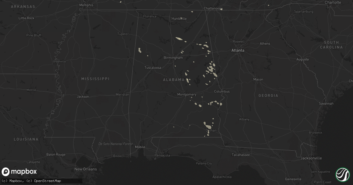
Hail Map in Alabama on August 12, 2023
Get this storm
August 12 map
$229
one time, instant access
Download today. No call, no setup
Keep the $229
Bought the map and want the full workflow? Apply the entire $229 to a subscription within 7 days. None of it is wasted.
Every map, not just this one
This buys you this map. Subscription and you get every map we run, in the markets you choose from a few cities to whole states to nationwide. Plus real-time alerts the moment a storm fires.
Contact data
Name, contact info, occupancy, even credit band for addresses in the footprint. You go from where it hit to who to call.
Become the source they trust
Unlimited branding weather history reports on demand. You already have the documented answer ready for the property owner, and you are the one who showed up with it.
Property data and RoofTrace estimates
Pull up any address you have got, its value and the exact code rules for that jurisdiction, straight from One Click Code. Then RoofTrace estimates the squares, pitch, and roof value, priced the way you price.
Storm reports in Alabama
Alabama
| Date | Description |
|---|---|
| 08/12/20236:50 PM CDT | A few trees were blown down on cr 2 near lake martin. |
| 08/12/20236:34 PM CDT | A few trees were blown down near cr 8. |
| 08/12/20235:58 PM CDT | Trees down in the area of county roads 48 and 54. |
| 08/12/20235:55 PM CDT | Tree down along the tallapoosa/chambers county line on dudleyville rd. |
| 08/12/20235:50 PM CDT | Tree down near the intersection of county roads 158 and 160. |
| 08/12/20235:36 PM CDT | Several trees down by downburst near shorter. Time estimated via radar. |
| 08/12/20235:34 PM CDT | Tree down with vehicle accident on old u.s. 431 and home damaged by lightning on highland ave. |
| 08/12/20235:21 PM CDT | Tree down near lee road 236 and lee road 5 in phenix city. |
| 08/12/20235:10 PM CDT | Several trees down on county roads 15... 26... And 49. |
| 08/12/20235:01 PM CDT | Tree down on lee road 146 near highway 51. |
| 08/12/20235:00 PM CDT | A fallen tree resulted in a power outage along s park ave. |
| 08/12/20234:57 PM CDT | There were at least 25 areas with trees down within the city of dothan. |
| 08/12/20234:57 PM CDT | Trees were blown down onto power lines on forrester road and a tree was snapped on beverlye road. |
| 08/12/20234:52 PM CDT | Public reported 2 trees down on hwy-52. |
| 08/12/20234:51 PM CDT | Geneva county dispatch reported a tree down on e cr-70. |
| 08/12/20234:49 PM CDT | A privacy fence was blown down in the headland area. |
| 08/12/20234:48 PM CDT | Henry county dispatch reported a tree and powerlines down on cr-5... 1900 block. |
| 08/12/20234:42 PM CDT | Three trees down on powerlines on state lake rd at highway 49. Road is blocked. |
| 08/12/20234:22 PM CDT | Social media report of several large trees down at st. Michael church. |
| 08/12/20234:21 PM CDT | A least a half dozen reports of trees blown down in the city of gadsden. |
| 08/12/20234:21 PM CDT | Trees were blown down. |
| 08/12/20234:15 PM CDT | Trees down near highway 278 along the cherokee/cleburne county line. |
| 08/12/20234:04 PM CDT | A tree was blown down and blocking the roadway on us highway 278. |
| 08/12/20234:00 PM CDT | Henry county emergency management reported trees down on residences on cr-107 east near abbeville. |
| 08/12/20233:36 PM CDT | Trees were blown down. |
| 08/12/20233:25 PM CDT | Coffee county dispatch reported 3 downed trees on cr-412. |
| 08/12/20233:21 PM CDT | Corrects previous tstm wnd dmg report from 1 nne gadsden. A least a half dozen reports of trees blown down in the city of gadsden. |
| 08/12/20233:21 PM CDT | Corrects previous tstm wnd dmg report from springville. Trees were blown down. |
| 08/12/20232:45 PM CDT | Multiple trees and power lines were blown down on al highway 75 north of oneonta. The highway was impassable near souls chapel road. |
| 08/12/20232:45 PM CDT | Multiple trees were blown down on al highway 75 north of oneonta. |
| 08/12/20232:38 PM CDT | Multiple trees were blown down on highway 79 near blountsville. The highway is impassable in spots. |
| 08/12/20232:38 PM CDT | Multiple trees were blown down on highway 79 north of cleveland. |
| 08/12/20232:13 PM CDT | Report of a tree down near the 100 block of county road 798 west of holly pond. Time estimated by radar. |
| 08/12/20232:13 PM CDT | Report of a tree down near the 700 block of county road 783 west of holly pond. Time estimated by radar. |
All States Impacted by Hail Map on August 12, 2023
Cities Impacted by Hail Map on August 12, 2023
- Columbus, IN
- Kenton, OH
- Bellevue, OH
- Castalia, OH
- Sandusky, OH
- Huron, OH
- Morral, OH
- Marion, OH
- Linesville, PA
- Conneautville, PA
- Bowling Green, KY
- Nashville, IN
- Gravel Switch, KY
- Bradfordsville, KY
- Whitewater, MO
- Troy, TN
- Union City, TN
- Rives, TN
- Martinsville, IN
- Mooresville, IN
- Bronston, KY
- Ridgely, TN
- Ada, OH
- Kenton, TN
- Belton, KY
- Drakesboro, KY
- Saint Charles, KY
- Nortonville, KY
- Scott City, MO
- Chaffee, MO
- Oran, MO
- Benton, MO
- Fulton, KY
- South Fulton, TN
- Seymour, IN
- Republic, OH
- Edmonton, KY
- Knob Lick, KY
- McKenzie, TN
- Alger, OH
- Campbellsburg, IN
- White Plains, KY
- Lewisburg, KY
- Rochester, KY
- Morgantown, KY
- Murray, KY
- Burnside, KY
- Paducah, KY
- West Paducah, KY
- Williamsburg, KY
- Corbin, KY
- Washington, IN
- Cannelburg, IN
- Loogootee, IN
- Montgomery, IN
- Jasper, IN
- Otwell, IN
- Orleans, IN
- Salem, IN
- Palmyra, TN
- East Prairie, MO
- Bertrand, MO
- Dover, TN
- Indian Mound, TN
- Cedar Grove, TN
- Huntingdon, TN
- Stewart, TN
- Big Sandy, TN
- Chanute, KS
- Benedict, KS
- Yates Center, KS
- Buffalo, KS
- Dukedom, TN
- Morgantown, IN
- Nineveh, IN
- Dawson Springs, KY
- Princeton, KY
- Lebanon, KY
- Fort Scott, KS
- Redfield, KS
- Wildersville, TN
- Grand Rivers, KY
- Smithland, KY
- Hornbeak, TN
- Louisville, KY
- Martin, TN
- Hickman, KY
- New Madrid, MO
- Clinton, KY
- Charleston, MO
- Brookport, IL
- Bethel Springs, TN
- Hornsby, TN
- Greenfield, TN
- Rutherford, TN
- Waverly, TN
- Whitley City, KY
- Parkers Lake, KY
- McIntire, IA
- Lima, OH
- Science Hill, KY
- Liberty, KY
- Bethelridge, KY
- Windsor, KY
- Greensburg, KY
- Vanlue, OH
- Findlay, OH
- Carey, OH
- Alvada, OH
- Mayfield, KY
- Wingo, KY
- Dola, OH
- Ledbetter, KY
- Fostoria, OH
- Tennessee Ridge, TN
- Trafalgar, IN
- Monticello, KY
- Fredonia, KY
- Campbellsville, KY
- Glasgow, KY
- Hazel, KY
- Buchanan, TN
- New Concord, KY
- Shepherdsville, KY
- Mount Washington, KY
- Sikeston, MO
- Matthews, MO
- Trezevant, TN
- Harrod, OH
- Bluffton, OH
- Beechmont, KY
- Beech Creek, KY
- Greenville, KY
- Browder, KY
- Palmyra, IN
- Bradford, TN
- Atwood, TN
- Cumberland City, TN
- Yuma, TN
- Roachdale, IN
- Attica, IN
- Obion, TN
- Freetown, IN
- Franklin, IN
- Brooklyn, IN
- Bargersville, IN
- Arcadia, OH
- New Albany, IN
- Lanesville, IN
- Taylorsville, KY
- Elizabeth, IN
- Georgetown, IN
- Arlington, OH
- Mount Blanchard, OH
- Cairo, IL
- Roundhill, KY
- Brownsville, KY
- Lexington, TN
- Oakland, KY
- Beaverdam, OH
- Columbus Grove, OH
- Tiffin, OH
- Green Springs, OH
- Henderson, TN
- Bell City, MO
- New Bloomington, OH
- Jenera, OH
- Waynesfield, OH
- La Rue, OH
- Belle Center, OH
- Bellville, OH
- Butler, OH
- Perrysville, OH
- Loudonville, OH
- Knoxville, TN
- Newfield, NY
- Ithaca, NY
- Spencer, NY
- Van Etten, NY
- Seymour, TN
- Franklin, PA
- Cooperstown, PA
- Oil City, PA
- Titusville, PA
- Pleasantville, PA
- Killbuck, OH
- Millersburg, OH
- Glenmont, OH
- Big Prairie, OH
- Kent, OH
- Ravenna, OH
- Rootstown, OH
- Nemo, SD
- Deadwood, SD
- Rapid City, SD
- Hill City, SD
- Black Hawk, SD
- Diamond, OH
- Newton Falls, OH
- Lake Milton, OH
- North Jackson, OH
- Berlin Center, OH
- New Philadelphia, OH
- Dover, OH
- Youngstown, OH
- Canfield, OH
- Apache, OK
- Eldorado, OK
- Mount Juliet, TN
- Lebanon, TN
- Murfreesboro, TN
- Lascassas, TN
- Watertown, TN
- Milton, TN
- Brush Creek, TN
- Hickman, TN
- Alexandria, TN
- Waldron, KS
- Liberty, TN
- Auburntown, TN
- Readyville, TN
- Woodbury, TN
- Bradyville, TN
- Dowelltown, TN
- Lancaster, TN
- Manchester, TN
- Smithville, TN
- Morrison, TN
- Mcminnville, TN
- Christiana, TN
- Baxter, TN
- Sparta, TN
- Silver Point, TN
- Buffalo Valley, TN
- Dennison, OH
- Sherrodsville, OH
- Bowerston, OH
- Emporium, PA
- Driftwood, PA
- Sinnamahoning, PA
- Westport, PA
- Pottersdale, PA
- Coatesville, PA
- Kennett Square, PA
- West Chester, PA
- Parrottsville, TN
- Greeneville, TN
- Marshall, NC
- Campbell, OH
- Struthers, OH
- Lowellville, OH
- Altus, OK
- Headrick, OK
- Keystone, SD
- Elmer, OK
- Elgin, OK
- Mills River, NC
- Horse Shoe, NC
- Hendersonville, NC
- Hermosa, SD
- Caputa, SD
- Rock Island, TN
- Walling, TN
- Quebeck, TN
- Spencer, TN
- Doyle, TN
- Fletcher, OK
- Hankins, NY
- Long Eddy, NY
- Roscoe, NY
- Fremont Center, NY
- North Branch, NY
- Jeffersonville, NY
- Livingston Manor, NY
- Liberty, NY
- Walton, NY
- East Branch, NY
- Downsville, NY
- Hamden, NY
- Delancey, NY
- Jewett, OH
- Amsterdam, OH
- Hopedale, OH
- Bloomingdale, OH
- Steubenville, OH
- Richmond, OH
- Carrollton, GA
- Cookeville, TN
- Parksville, NY
- Rome, PA
- Warren Center, PA
- Whitesburg, GA
- Odell, TX
- Olustee, OK
- Vernon, TX
- Little Meadows, PA
- Pipersville, PA
- Doylestown, PA
- New Hope, PA
- Scenic, SD
- Atlanta, GA
- Burgettstown, PA
- Avella, PA
- McDonald, PA
- Hickory, PA
- Cadiz, OH
- Apollo, PA
- New Kensington, PA
- Pine Ridge, SD
- Spearfish, SD
- Electra, TX
- Grandfield, OK
- Adena, OH
- Dillonvale, OH
- Avonmore, PA
- Saltsburg, PA
- Sterling, NY
- Hannibal, NY
- Oswego, NY
- Oneida, NY
- Verona, NY
- Vernon, NY
- Rome, NY
- Oriskany, NY
- Smithfield, OH
- Rayland, OH
- Iowa Park, TX
- Custer, SD
- Sundance, WY
- Napanoch, NY
- Ellenville, NY
- Kerhonkson, NY
- Wawarsing, NY
- Athens, OH
- Beech Bottom, WV
- Wellsburg, WV
- Bethany, WV
- Wheeling, WV
- Canute, OK
- Foss, OK
- Dill City, OK
- Cordell, OK
- Andover, OH
- Pierpont, OH
- Redfield, NY
- Camden, NY
- Trumansburg, NY
- Hulett, WY
- Anthony, KS
- Potts Camp, MS
- Roanoke, AL
- Carmen, OK
- Sunbright, TN
- Robbins, TN
- Hartley, TX
- Arden, NC
- Etowah, NC
- Fletcher, NC
- Lawton, OK
- Aberdeen, MS
- Williamstown, NY
- Clayton, NM
- Moody, AL
- Odenville, AL
- Anadarko, OK
- Cement, OK
- Altmar, NY
- Burton, OH
- Newbury, OH
- Fremont, OH
- Five Points, AL
- Lanett, AL
- Rouseville, PA
- Frederick, OK
- Snyder, OK
- Tipton, OK
- Fort Sill, OK
- Buena Vista, GA
- Monroeville, OH
- Berkshire, NY
- Newark Valley, NY
- Piedmont, AL
- Headland, AL
- Marlow, OK
- Pratt, KS
- Turon, KS
- Union City, PA
- Centerville, PA
- Saegertown, PA
- Spartansburg, PA
- Cambridge Springs, PA
- Gould, OK
- Duke, OK
- Ozark, AL
- Clyde, OH
- Baker, FL
- Jacksonville, AL
- Aragon, GA
- North Port, FL
- Port Charlotte, FL
- Franklin, GA
- Rawson, OH
- Colliers, WV
- Angel Fire, NM
- Vernon, AL
- Millport, AL
- Kennedy, AL
- Eglin Afb, FL
- Valparaiso, FL
- Niceville, FL
- Hughesville, PA
- Cyril, OK
- Lakeville, OH
- Lucas, OH
- Mansfield, OH
- New Washington, OH
- Plymouth, OH
- Shelby, OH
- Shiloh, OH
- Nova, OH
- Bloomville, OH
- Ashland, OH
- Greenwich, OH
- Sullivan, OH
- Tiro, OH
- Alva, OK
- Benezett, PA
- Toccoa, GA
- Bergholz, OH
- Carrollton, OH
- Snellville, GA
- Lithonia, GA
- Dalhart, TX
- East Sparta, OH
- Canton, OH
- Lagrange, GA
- Amarillo, TX
- Lancing, TN
- Girard, OH
- Hubbard, OH
- Sugarcreek, OH
- Munroe Falls, OH
- Hillsville, PA
- Cuyahoga Falls, OH
- Akron, OH
- Edinburg, PA
- Deerfield, OH
- Tallmadge, OH
- Atwater, OH
- West Point, MS
- Woodland, AL
- Renovo, PA
- Saint Marys, PA
- Yuma, CO
- Brooktondale, NY
- Gibsonia, PA
- Allison Park, PA
- Glenshaw, PA
- Cheswick, PA
- Pittsburgh, PA
- Indianola, PA
- Fort Cobb, OK
- Balmorhea, TX
- Scottsboro, AL
- Waynesburg, OH
- Equinunk, PA
- Scio, OH
- Alpine, NY
- Mexico, NY
- Pulaski, NY
- Muse, PA
- Canonsburg, PA
- Houston, PA
- Pickens, SC
- Sunset, SC
- Lead, SD
- Dayton, TN
- Bucyrus, OH
- Dundee, NY
- Hammondsport, NY
- Waverly, AL
- Berwick, PA
- Rush Springs, OK
- Buchanan, GA
- Cedartown, GA
- Rockmart, GA
- Attica, KS
- Dunmor, KY
- Greencastle, IN
- Dadeville, AL
- Newcastle, WY
- Altoona, AL
- Oneonta, AL
- Chatsworth, GA
- Springville, TN
- Novelty, OH
- Fayette, AL
- Ninnekah, OK
- Wedowee, AL
- Pritchett, CO
- Williamsport, IN
- Downingtown, PA
- Auburn, AL
- Olivehill, TN
- Blountsville, AL
- Carnesville, GA
- Warsaw, OH
- Heflin, AL
- Sedan, NM
- Conyers, GA
- Oxford, GA
- Sarasota, FL
- Holly Springs, MS
- Fruithurst, AL
- Columbus, PA
- Corry, PA
- Wartburg, TN
- Westville, FL
- Floyds Knobs, IN
- Schwenksville, PA
- Evergreen, AL
- Eastanollee, GA
- Martin, GA
- Sevierville, TN
- Walland, TN
- Millville, PA
- Benton, PA
- Orangeville, PA
- Unityville, PA
- Harwick, PA
- Creighton, PA
- Springdale, PA
- Tarentum, PA
- Chickasha, OK
- Wadley, AL
- Highlands, NC
- Franklin, NC
- Galion, OH
- Elba, AL
- Stockbridge, GA
- Midland City, AL
- Tippecanoe, OH
- Port Washington, OH
- Newcomerstown, OH
- Dalton, GA
- Rocky Face, GA
- Tunnel Hill, GA
- Powell, TN
- Ringgold, GA
- Minerva, OH
- Mechanicstown, OH
- Malvern, OH
- Cleveland, TN
- Apison, TN
- Hanceville, AL
- Cullman, AL
- Holly Pond, AL
- Abbeville, AL
- Cohutta, GA
- Sulligent, AL
- Walhonding, OH
- Frazeysburg, OH
- Nevada, OH
- Mount Gilead, OH
- Baltic, OH
- Caledonia, OH
- Edison, OH
- Faxon, OK
- Newville, AL
- Guysville, OH
- Claysville, PA
- West Alexander, PA
- Kyle, SD
- Kadoka, SD
- Belvidere, SD
- Long Valley, SD
- Washington, PA
- Prosperity, PA
- Amity, PA
- Scenery Hill, PA
- New Paltz, NY
- Gardiner, NY
- Wallkill, NY
- Modena, NY
- Highland, NY
- Marlboro, NY
- Newburgh, NY
- Clintondale, NY
- Milton, NY
- Wappingers Falls, NY
- Beacon, NY
- Cold Spring, NY
- Chelsea, NY
- Poughkeepsie, NY
- Fishkill, NY
- Hopewell Junction, NY
- Carmel, NY
- Stormville, NY
- Holmes, NY
- New Matamoras, OH
- Friendly, WV
- Sistersville, WV
- Fairburn, SD
- White River, SD
- Carrolltown, PA
- Ebensburg, PA
- Loretto, PA
- Gallitzin, PA
- Ashville, PA
- Duncansville, PA
- Patton, PA
- Elmora, PA
- Chest Springs, PA
- Middlebourne, WV
- Sycamore, PA
- Waynesburg, PA
- Jefferson, PA
- Fredericktown, PA
- Clarksville, PA
- Marianna, PA
- Brownsville, PA
- La Belle, PA
- Vestaburg, PA
- East Millsboro, PA
- Millsboro, PA
- Mather, PA
- Carmichaels, PA
- Crucible, PA
- Rices Landing, PA
- Adah, PA
- Nemacolin, PA
- Masontown, PA
- Ronco, PA
- Denbo, PA
- McClellandtown, PA
- Uledi, PA
- Uniontown, PA
- New Salem, PA
- Republic, PA
- Fairbank, PA
- Merrittstown, PA
- Cardale, PA
- Smithfield, PA
- Penn Run, PA
- Northern Cambria, PA
- Nicktown, PA
- Strongstown, PA
- Colver, PA
- Lilly, PA
- Cresson, PA
- Portage, PA
- Cassandra, PA
- Altoona, PA
- Hollidaysburg, PA
- Sturgis, SD
- Vale, SD
- Fairchance, PA
- Farmington, PA
- Hopwood, PA
- Brownfield, PA
- Newry, PA
- Garden City, KS
- Ingalls, KS
- Pierceville, KS
- Sublette, KS
- Ulysses, KS
- Porcupine, SD
- New Underwood, SD
- Bruceton Mills, WV
- Gibbon Glade, PA
- Friendsville, MD
- Markleysburg, PA
- Martinsburg, PA
- Williamsburg, PA
- Hesston, PA
- James Creek, PA
- Accident, MD
- Lairdsville, PA
- Muncy, PA
- Stillwater, PA
- Manderson, SD
- Batesland, SD
- Allen, SD
- Martin, SD
- Wounded Knee, SD
- Wood Lake, NE
- Johnstown, NE
- Ainsworth, NE
- Tuthill, SD
- Moorcroft, WY
- Lafayette, AL
- Oswegatchie, NY
- Harrisville, NY
- Lindsay, OK
- Mannsville, NY
- Grahamsville, NY
- Carter, OK
- Granite, OK
- Paducah, TX
- Fountainville, PA
- Perkasie, PA
- Hilltown, PA
- Chalfont, PA
- Hatfield, PA
- Wanblee, SD
- Pike Road, AL
- Rockford, AL
- Union Center, SD
- Valentine, NE
- Towanda, PA
- Wysox, PA
- Morris, GA
- Georgetown, GA
- Groom, TX
- Pampa, TX
- Edgemont, SD
- Lacona, NY
- Leesville, OH
- Graysville, OH
- Fishs Eddy, NY
- Hancock, NY
- Quanah, TX
- Sentinel, OK
- Uhrichsville, OH
- Gnadenhutten, OH
- Pendleton, SC
- Anderson, SC
- Stone Ridge, NY
- Norris, SD
- Parmelee, SD
- Petersburg, TX
- East Rochester, OH
- East Canton, OH
- Kensington, OH
- Alford, FL
- Cottondale, FL
- Chipley, FL
- Columbus, MS
- Cold Brook, NY
- Hoffmeister, NY
- Defuniak Springs, FL
- Mission, SD
- Talladega, AL
- Troy, AL
- Fitzpatrick, AL
- Prairie, MS
- Freeport, OH
- Sunray, TX
- Valley Grove, WV
- West Liberty, WV
- Macon, GA
- Niles, OH
- McDonald, OH
- Dawson, GA
- Plains, GA
- Union Springs, AL
- Banks, AL
- Fallsburg, NY
- Greenfield Park, NY
- Swan Lake, NY
- Callicoon, NY
- Youngsville, NY
- Hurleyville, NY
- Woodbourne, NY
- Loch Sheldrake, NY
- White Sulphur Springs, NY
- Ferndale, NY
- Woodridge, NY
- Midway, AL
- Cottekill, NY
- Accord, NY
- Olivebridge, NY
- Kingston, NY
- Salineville, OH
- Hammondsville, OH
- Sandy Creek, NY
- Gadsden, AL
- Walden, NY
- Smithton, PA
- Mount Pleasant, PA
- Ruffs Dale, PA
- Tarrs, PA
- Alverton, PA
- Harleysville, PA
- Souderton, PA
- Parrott, GA
- Pleasant Valley, NY
- Lagrangeville, NY
- Saluda, NC
- Flat Rock, NC
- Royston, GA
- Dumas, TX
- Trussville, AL
- Wood, SD
- Slocomb, AL
- Hartford, AL
- Hyde Park, NY
- Cedar Vale, KS
- Arnoldsville, GA
- Winterville, GA
- Honea Path, SC
- Belton, SC
- Indiahoma, OK
- Crestview, FL
- Titus, AL
- Equality, AL
- Lock Haven, PA
- Weogufka, AL
- Sylacauga, AL
- Elberton, GA
- Coolville, OH
- Gruver, TX
- Butler, OK
- Clinton, OK
- Remsen, NY
- Pelham, AL
- Alabaster, AL
- Columbiana, AL
- Pittsview, AL
- New Fairfield, CT
- Brewster, NY
- Patterson, NY
- Pawling, NY
- Masterson, TX
- Eufaula, AL
- Smithville, WV
- Macfarlan, WV
- Petroleum, WV
- Harrisville, WV
- Athens, PA
- Sayre, PA
- Ulster, PA
- Dexter City, OH
- Macksburg, OH
- Caldwell, OH
- Lower Salem, OH
- Alverda, PA
- Mentcle, PA
- Hamilton, MS
- Texline, TX
- Saint Clairsville, OH
- Dothan, AL
- Newton, AL
- Felt, OK
- Holt, FL
- Wellington, AL
- Glenmoore, PA
- Sherrill, NY
- Mineral Wells, WV
- Parkersburg, WV
- Washington, WV
- Carnegie, OK
- Stone Creek, OH
- Warren, OH
- Guymon, OK
- Goodwell, OK
- Red Creek, NY
- Wexford, PA
- Verona, PA
- Clarksburg, PA
- Waterford, MS
- Jeffersonville, GA
- Stratford, TX
- White Deer, TX
- Adams, NY
- Lorraine, NY
- New Castle, PA
- Marianna, FL
- Ramer, AL
- Lumpkin, GA
- Omaha, GA
- Spraggs, PA
- Milton, FL
- Jay, FL
- Mount Clare, WV
- Lost Creek, WV
- Medicine Park, OK
- Cache, OK
- Springville, AL
- Wetumpka, AL
- Wingett Run, OH
- Benwood, WV
- Bellaire, OH
- Bridgeport, OH
- Brownsboro, AL
- Huntsville, AL
- West Shokan, NY
- Heilwood, PA
- Clymer, PA
- Lone Wolf, OK
- Central, SC
- Ulster Park, NY
- Loveland, OK
- Somerset, KY
- Hardaway, AL
- Tuskegee, AL
- Holbrook, PA
- Mingo Junction, OH
- Follansbee, WV
- Midvale, OH
- Strabane, PA
- Fresno, OH
- Westland, PA
- Campbellton, FL
- Graceville, FL
- Merriman, NE
- Cody, NE
- Long Pine, NE
- Bassett, NE
- Collegeville, PA
- Skippack, PA
- Blue Bell, PA
- Norristown, PA
- Lansdale, PA
- Telford, PA
- Green Lane, PA
- Perkiomenville, PA
- Sellersville, PA
- Bechtelsville, PA
- Fleetwood, PA
- Boyertown, PA
- Reading, PA
- Gilbertsville, PA
- Frederick, PA
- Oley, PA
- Pennsburg, PA
- Barto, PA
- Temple, PA
- Leesport, PA
- Birdsboro, PA
- Pottstown, PA
- Douglassville, PA
- Mohnton, PA
- Zieglerville, PA
- Royersford, PA
- Bernville, PA
- Mohrsville, PA
- Robesonia, PA
- Richland, PA
- Womelsdorf, PA
- Wernersville, PA
- Myerstown, PA
- Reinholds, PA
- Lebanon, PA
- Newmanstown, PA
- Denver, PA
- Hot Springs, SD
- Lance Creek, WY
- Oelrichs, SD
- Smithwick, SD
- Glen Head, NY
- Roslyn Heights, NY
- Port Washington, NY
- Mineola, NY
- Carle Place, NY
- Manhasset, NY
- Old Westbury, NY
- Roslyn, NY
- East Norwich, NY
- Westbury, NY
- Albertson, NY
- Greenvale, NY
- Williston Park, NY
- Great Neck, NY
- Little Neck, NY
- Oyster Bay, NY
- Bayside, NY
- Glenwood Landing, NY
- New Hyde Park, NY
- Glen Oaks, NY
- Oakland Gardens, NY
- Bellerose, NY
- Floral Park, NY
- Garden City, NY
- Malverne, NY
- Elmont, NY
- Rockville Centre, NY
- Franklin Square, NY
- West Hempstead, NY
- Lynbrook, NY
- Hempstead, NY
- Valley Stream, NY
- Uniondale, NY
- Roosevelt, NY
- Freeport, NY
- Baldwin, NY
- East Meadow, NY
- Merrick, NY
- Bellmore, NY
- Jericho, NY
- Syosset, NY
- Wantagh, NY
- Bethpage, NY
- Levittown, NY
- Hicksville, NY
- Plainview, NY
- Old Bethpage, NY
- Woodbury, NY
- Melville, NY
- Huntington, NY
- Cold Spring Harbor, NY
- Hays, KS
- Spavinaw, OK
- Mills, NE
- Springview, NE
- Eucha, OK
- Sparks, NE
- New Cambria, KS
- Newport, NE
- Winner, SD
- Hoskins, NE
- Winside, NE
- Salina, KS
- Ramona, OK
- Talala, OK
- Stuart, NE
- Clearwater, NE
- Bloomingburg, NY
- Pine Bush, NY
- Lititz, PA
- Ephrata, PA
- Stevens, PA
- Pekin, IN
- Kilgore, NE
- Saint Francis, SD
- Schaefferstown, PA
- Manheim, PA
- Walker, WV
- Carroll, NE
- Strang, OK
- Nenzel, NE
- Walker, KS
- Victoria, KS
- Gorham, KS
- Fritch, TX
- Wayne, NE
- Atkinson, NE
- Lincoln, NE
- Wilson, KS
- Claflin, KS
- Stanton, NE
- Norfolk, NE
- Hoisington, KS
- Hindsville, AR
- Rogers, AR
- Sayville, NY
- Ocean Beach, NY
- Great River, NY
- Utica, NY
- Westmoreland, NY
- Green Forest, AR
- Alpena, AR
- Fayetteville, AR
- Lambertville, NJ
- Thorndale, PA
- Huntsville, AR
- Vinita, OK
- Council Grove, KS
- Allen, KS
- Ava, NY
- Lee Center, NY
- Oneill, NE
- Inman, NE
- Page, NE
- Ewing, NE
- Orchard, NE
- Royal, NE
- Poughquag, NY
- Durhamville, NY
- Berryville, AR
- Lusk, WY
- Boonville, NY
- Kenton, OK
- Springdale, AR
- Southampton, NY
- Water Mill, NY
- Ringoes, NJ
- Jay, OK
- Big Cabin, OK
- Pryor, OK
- Salina, OK
- Stittville, NY
- Holland Patent, NY
- Adair, OK
- Lowell, AR
- Oologah, OK
- Chelsea, OK
- Ridge, NY


