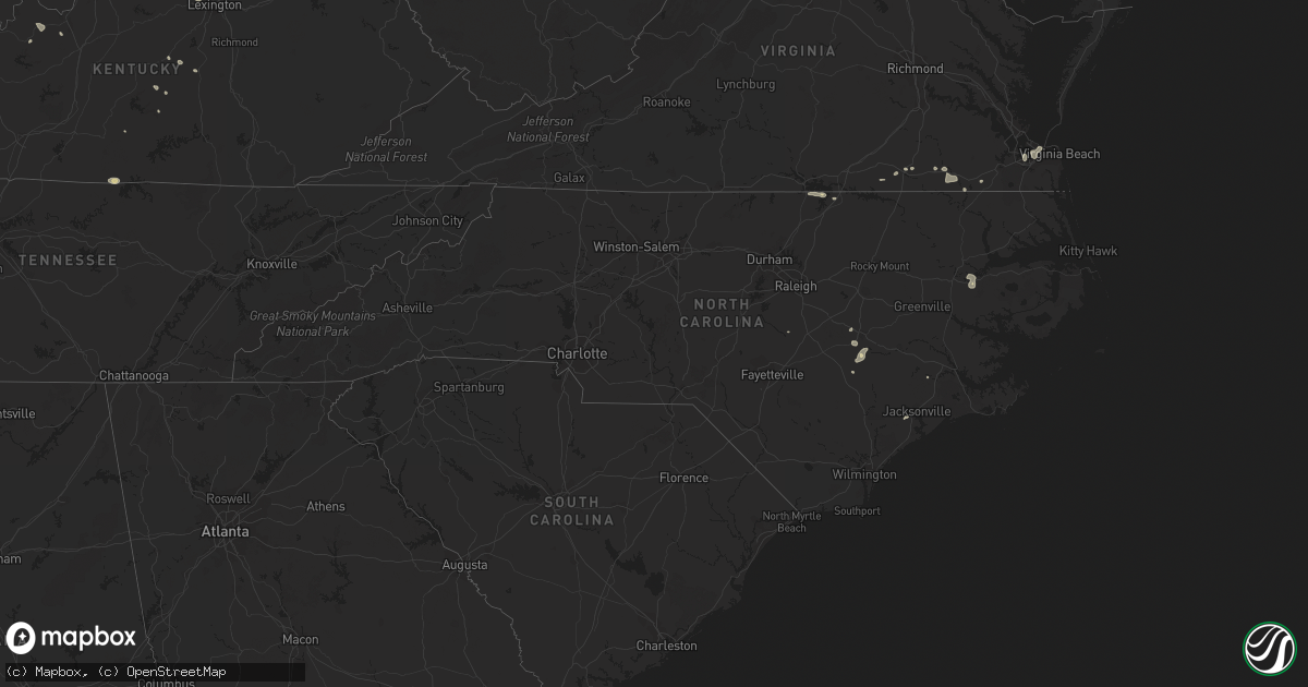
Hail Map in North Carolina on August 11, 2018
Get this storm
August 11 map
$229
one time, instant access
Download today. No call, no setup
Keep the $229
Bought the map and want the full workflow? Apply the entire $229 to a subscription within 7 days. None of it is wasted.
Every map, not just this one
This buys you this map. Subscription and you get every map we run, in the markets you choose from a few cities to whole states to nationwide. Plus real-time alerts the moment a storm fires.
Contact data
Name, contact info, occupancy, even credit band for addresses in the footprint. You go from where it hit to who to call.
Become the source they trust
Unlimited branding weather history reports on demand. You already have the documented answer ready for the property owner, and you are the one who showed up with it.
Property data and RoofTrace estimates
Pull up any address you have got, its value and the exact code rules for that jurisdiction, straight from One Click Code. Then RoofTrace estimates the squares, pitch, and roof value, priced the way you price.
Storm reports in North Carolina
North Carolina
| Date | Description |
|---|---|
| 08/11/20183:25 PM CDT | One tree blown down on the 500 block of forehand road in pikeville. |
| 08/11/20187:59 AM CDT | At 1259 AM EDT, a severe thunderstorm was located near Troy, moving northeast at 20 mph. HAZARD...60 mph wind gusts and penny size hail. SOURCE...Radar indicated. IMPACT...Expect damage to roofs, siding, and trees. Locations impacted include... Troy, North Carolina Zoo, Biscoe, Seagrove, Robbins, Star and Steeds. |
| 08/10/201811:14 PM CDT | At 414 PM EDT, severe thunderstorms were located along a line extending from near Fremont to near Goldsboro to 7 miles north of Mount Olive, moving east at 15 mph. HAZARD...60 mph wind gusts and quarter size hail. SOURCE...Radar indicated. IMPACT...Hail damage to vehicles is expected. Expect wind damage to roofs, siding, and trees. Locations impacted include... Goldsboro, Mount Olive, Fremont, Walnut Creek, Stantonsburg, Black Creek, Pikeville, Eureka, Seven Springs and Mar-Mac. |
| 08/10/201810:14 PM CDT | At 313 AM EDT, a severe thunderstorm was located near Pope AFB, or 8 miles north of Fort Bragg, moving east at 20 mph. HAZARD...60 mph wind gusts. SOURCE...Radar indicated. IMPACT...Expect damage to roofs, siding, and trees. Locations impacted include... Fayetteville, Lillington, Fort Bragg, Dunn, Godwin, Pope AFB, Spring Lake, Erwin, Coats and Wade. |
| 08/10/20189:29 PM CDT | At 229 PM EDT, a severe thunderstorm was located near Verona, or near New River Station, moving northeast at 25 mph. HAZARD...60 mph wind gusts and quarter size hail. SOURCE...Radar indicated. IMPACT...Hail damage to vehicles is expected. Expect wind damage to roofs, siding, and trees. Locations impacted include... Jacksonville, New River Station, Half Moon, Pumpkin Center, Piney Green, Camp Lejeune Center, Kellum, Midway Park, Verona, Catherine Lake, Richlands South, Deppe, Haws Run and Loco VFD. |
| 08/10/20188:53 PM CDT | At 153 AM EDT, a severe thunderstorm was located 7 miles southwest of Carthage, moving east at 25 mph. HAZARD...60 mph wind gusts and penny size hail. SOURCE...Radar indicated. IMPACT...Expect damage to roofs, siding, and trees. Locations impacted include... Sanford, Southern Pines, Carthage, Pinehurst, Whispering Pines, Foxfire, Taylortown, Vass, Cameron and Lemon Springs. |
All States Impacted by Hail Map on August 11, 2018
Cities Impacted by Hail Map on August 11, 2018
- Colorado City, AZ
- Hestand, KY
- Burkesville, KY
- Tompkinsville, KY
- Celina, TN
- Wagoner, OK
- Hulbert, OK
- Fort Gibson, OK
- Kingman, AZ
- Meadview, AZ
- Littlefield, AZ
- Clovis, NM
- Williams, AZ
- Brooksville, KY
- Luther, OK
- Weatherford, OK
- Jones, OK
- Clarendon, TX
- Elk Horn, KY
- Liberty, KY
- Versailles, KY
- Midway, KY
- Georgetown, KY
- Golden Valley, AZ
- Hackberry, AZ
- Peach Springs, AZ
- Auburn, IN
- Spencerville, IN
- Saint Joe, IN
- Bentonville, AR
- Beryl, UT
- Panguitch, UT
- Newport, NJ
- Kansas, OK
- Hennessey, OK
- Lexington, KY
- Rhodes, MI
- Luther, MI
- Baldwin, MI
- Winslow, AR
- Goldsboro, NC
- Arapaho, OK
- Frankfort, KY
- Lawrenceburg, KY
- Napoleon, OH
- Milford, UT
- Hedley, TX
- Lelia Lake, TX
- Plains, TX
- Overton, NV
- Dolan Springs, AZ
- Luxora, AR
- Clinton, OK
- Cynthiana, KY
- Paris, KY
- Marlin, TX
- Carlisle, KY
- Sharpsburg, KY
- Butler, OK
- Arcadia, OK
- Geary, OK
- Henderson, NC
- Middleville, MI
- Hastings, MI
- Glendale, UT
- Faison, NC
- Childress, TX
- Chelsea, MI
- Gregory, MI
- Munith, MI
- Grass Lake, MI
- Stockbridge, MI
- Parsons, TN
- Lexington, TN
- Decaturville, TN
- Darden, TN
- Jackson, TN
- Rose, OK
- Defiance, OH
- King Of Prussia, PA
- Wayne, PA
- Bullhead City, AZ
- Virginia Beach, VA
- Norfolk, VA
- Chesapeake, VA
- Decatur, AR
- Holgate, OH
- Vine Grove, KY
- Beech Grove, AR
- Bono, AR
- Guthrie, OK
- Coyle, OK
- Perkins, OK
- Spencer, WV
- Looneyville, WV
- Tahlequah, OK
- Chloe, WV
- Newton, WV
- Mangum, OK
- West Chester, OH
- Mason, OH
- Hamilton, OH
- Capron, VA
- Berryville, AR
- Smyrna, DE
- Townsend, DE
- Cardwell, MO
- Arbyrd, MO
- Fordsville, KY
- Dundee, KY
- Olaton, KY
- Hartford, KY
- Bannister, MI
- Elsie, MI
- Suffolk, VA
- Cordell, OK
- Paragonah, UT
- Boulder City, NV
- Latonia, KY
- Elkhart Lake, WI
- Dansville, MI
- Albuquerque, NM
- Emporia, VA
- Crofton, KY
- Milan, MI
- Aurora, IN
- Trenton, OH
- Rodney, MI
- Mecosta, MI
- West Fork, AR
- Jackson, MI
- Brooklyn, MI
- McDermott, OH
- West Portsmouth, OH
- Nazareth, TX
- Tulia, TX
- Olustee, OK
- Chickasha, OK
- Amber, OK
- Conshohocken, PA
- Villanova, PA
- Gladwyne, PA
- Beaver Dam, KY
- Reynolds Station, KY
- Catlettsburg, KY
- Tijeras, NM
- Edgewood, NM
- Bristow, OK
- Pollocksville, NC
- Trenton, NC
- Jamesville, NC
- Bells, TN
- Bentley, MI
- Guilford, IN
- Lawrenceburg, IN
- Moores Hill, IN
- Elkton, MD
- Oxford, PA
- Rising Sun, MD
- Gravel Switch, KY
- Danville, KY
- Perryville, KY
- Media, PA
- Duck, WV
- Nebo, WV
- Wallback, WV
- Jacksonville, NC
- Dover, OK
- Leachville, AR
- Monette, AR
- Black Oak, AR
- Lake City, AR
- Vanceburg, KY
- Washington, UT
- Blytheville, AR
- Riesel, TX
- Reagan, TX
- California, KY
- Melrose, NM
- Chestertown, MD
- Lawrenceville, VA
- New Holstein, WI
- Mount Olive, NC
- East Greenville, PA
- Coopersburg, PA
- Zionsville, PA
- Beggs, OK
- Freeport, MI
- Granite, OK
- Bronson, TX
- Pineland, TX
- Grabill, IN
- Butler, IN
- Leo, IN
- Sunman, IN
- Oaks, OK
- Portsmouth, OH
- Lucasville, OH
- Vinson, OK
- Stanley, NM
- Grayson, KY
- Olive Hill, KY
- Muleshoe, TX
- Newsoms, VA
- Franklin, VA
- Stanford, KY
- Chandler, OK
- Happy, TX
- Texico, NM
- Pioneer, OH
- Courtland, VA
- Sparks, OK
- Galena, MO
- Cape Fair, MO
- Prescott, AZ
- Charlotte, TX
- Stamping Ground, KY
- Hollywood, FL
- Norlina, NC
- Manson, NC
- Portsmouth, VA
- Friona, TX
- Garfield, KY
- Harned, KY
- Napoleon, MI
- Norvell, MI
- Webberville, MI
- Kellyville, OK
- Corn, OK
- Seven Springs, NC
- Dudley, NC
- Blanchard, OK
- Dunnville, KY
- Columbia, KY
- Como, NC
- Millsboro, DE
- Frankford, DE
- Kingfisher, OK
- Melbourne, KY
- New Richmond, OH
- Coats, NC
- Guston, KY
- Irvington, KY
- Hydro, OK
- Bryn Mawr, PA
- Haverford, PA
- Bovina, TX
- Hudson, MI
- Washington Boro, PA
- Millersville, PA
- Hereford, TX
- Vidalia, LA
- Hope, MI
- Junction City, KY
- Bullock, NC
- Webbville, KY
- Middletown, DE
- Beaverton, MI
- Sedona, AZ


